PUBLIC SPACE IN THE PERI-URBAN SETTLEMENTS OF SARAJEVO.
A PROJECT FOR THE MAHALA OF ŠIROKAČA
Richard Lee PERAGINE
Department of Architecture, University of Ferrara, ITALY [email protected]
DOI: http://doi.org/10.23740/TID120191
ABSTRACT
This paper outlines a project for the reactivation of the peri-urban settlements, known as mahalas, which surround Sarajevo, Bosnia & Herzegovina. For historical, social and economic reasons, the growth of the mahalas has been largely informal and uncontrolled by planning regulations with the result that today they exemplify both the dysfunctions and the potentials of spontaneous and uncontrolled urban expansion. The absence of adequate urban planning, both previous to and following a period of armed conflict, together with a failed process of social reconstruction, has left the mahalas in a state of physical abandon and without a shared identity and memory of place. Lacking public infrastructure, they are cut off from the central parts of the city and from the services these provide. In terms of natural conditions, due to the steep slopes and the nature of the bedrock the area is vulnerable to landslides. A failure to address this problem has resulted in the construction of buildings in high-risk locations. This study examines a rethinking of the Širokača mahala. It identifies four strategic objectives: the reduction of landslide risk; the reconnection, both physical and psychological, with the city; the reactivation of the mahala through the provision of public spaces and services; the provision of new homes for the recollocation of the weakest elements of the population as part of the wider national programme for the recollocation of internally displaced people (IDPs). The project finds its guiding principle in a scattered approach consisting of a series of small scale interventions that together create a pathway of facilities which in turn can be reproduced at the macro-level of an urban system. Bottom-up initiatives and practices of urban resilience, latent potential of Sarajevo, are proposed in order to foster a process of physical and social reconciliation within the community.
Keywords: Bosnia and Herzegovina, post-conflict, peri-urban, Inter-Entity Boundary Line, resilience
INTRODUCTION
Urban framework
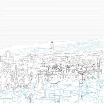
Figure 1: Sarajevo: Vratnik mahala (foreground in blue) and Aziz Tower (background in black) seen from Bijela Tabija, east of the Stari Grad and looking west toward modern city
developments and mahalas Source: Author, 2018
Today, Bosnia & Herzegovina is the product of a three-fold conflictual transition from communism to democracy, socialism to capitalism, and war to peace. The country ranks 81st on the Human
Development Index (UNDP, 2017), which is the second lowest index for the European continent, after Macedonia, and has a level of urbanisation of only 39.8% (CIA World Factbook, 2015) – the lowest in Europe and the same as Sierra Leone, in Africa. The official unemployment rate is 41.5% (United States of America Department of Commerce, 2017) with youth unemployment reaching 60% – the highest in the world (ILO, 2017).
the status quo of a bloody conflict that lasted from 1992 to 1995 rather than welcoming the return to a peaceful centuries-old coexistence. In fact, the Dayton Peace Agreement, which was the formal conclusion of the war in Bosnia in 1995, divided Bosnia & Herzegovina into two entities – the Federacija Bosne i Hercegovine, inhabited by most of the Croat-Muslim population, with Sarajevo as capital, and the Republika Srpska with most of the Bosnian-Serb people – along the Inter Entity Border Line (IEBL), an administrative border, now demilitarized, which followed the front line at the end of the war and is the result of a bargaining UN-promoted peace process. As Sarajevo was on the front line during the war, the entity border runs along the southern fringes of the city, also cutting through the mahalas, and dividing Sarajevo East, which is in the Republika Srpska, from the rest of the city. The repercussions of such a division are present in many aspects of private and public life: the constitution of Bosnia & Herzegovina has been indicated (Nardelli et al., 2014) as one of the most complicated and unclear in the world and is consequently an impediment to a smooth running social system and to the population’s welfare.
Sarajevo, centre of the world
Bosnia’s distinctive position between East and West has brought both good fortune and tragedy throughout its history. It is one of three European countries with a Muslim majority (together with Kosovo and Albania and excluding Turkey) and its geographical position has made it a cultural crossroads. Sarajevo, the capital and largest city in the country, is a city of ancient origins that has seen contrasting and opposing traditions, races and cultures live harmoniously for centuries. Once an emblem of tolerance and a cultural meeting point, known as ‘the Jerusalem of Europe’, the city is now an expression of the dynamics of the process which has transformed its multicultural heritage into a statement of hostility and division. Such a rich mixture of languages, religious faiths and ways of life created a distinctive pluralistic value system which Dževad Karahasan, Bosnian playwright and poet, defines as ‘dramatic’ (Karahasan, 1994). A dramatic system is one in which each element is defined by its contrasting relationship with another. The tension created by opposing elements allows comparison without modifying the peculiar characteristics each one previously possessed outside the system, so that the other becomes a necessary proof of one’s own identity. This system contrasts with a ‘dialectic’ system in which the parts are defined by hierarchical relationships which inevitably end in the elements devouring each other. Karahasan identifies this dramatic nature as the principal difference between pre-war Sarajevo, before its destruction by the siege that lasted from 1992 to 1995, and other contemporary Western cities. The cultural and religious identity of its inhabitants was affirmed through continual comparison:
‘[…] thanks to this continual contact the Catholic and the Muslim of the mahalas develop the knowledge of their own identity. Discovering another I discover myself, knowing
another I recognise myself’ (Karahasan, 1994, p. 23).
This ‘dramatic’ relationship defines an ‘interior city’ which contains in its nucleus, in miniature but nevertheless present, all the elements of the outside world. This interpretation of the city, while poetic, proves to be architecturally accurate and was an inspiring starting point for an understanding of the site-specific urban morphology and typology of the mahalas.
Economic unsustainability, physical geography and urban development
and political centre, the mechanisms and contradictions of these conflicts are particularly pronounced.
The Bosnian economy has grown significantly since the second half of the nineties. In the already mentioned seventies and eighties, the industrial sectors of heavy industry, mining and tobacco production were competitive both within the Yugoslav Federation and internationally, while agricultural production was in the hands of the private sector. Sarajevo produced 37% of the country’s GDP (Central Bank of Bosnia, 2011) and its inhabitants had some of the highest salaries in the Yugoslavian federation. During the war, production plummeted by 80% and despite considerable humanitarian and financial aid from foreign countries involved in the reconstruction process, the problems created by the war still slow down the Bosnian economy today. Economic data for the post 1995 period is unreliable because it does not reflect the black market. The reason for this substantial informal economy lies in economic instability and in the difficulties associated with doing business. While the economy relies on international aid and finance from emigrants, the strongly decentralised political system, as well as widespread institutional corruption, is an obstacle to foreign investment. The official unemployment rate is 41.5 % (United States of America Department of Commerce, 2017), though taking into account the effect of the black market the real figure is more likely between 20-27% (CIA, ILO, 2017); youth unemployment has reached 60% (ILO) – the highest in the world. As well as unemployment, the chief macroeconomic problem of the country is difficulty in doing business. Bosnia ranks 86th out of a total of 190 countries in the World Bank’s Ease of Doing Business
report (2017) because issues such as bureaucratic obstacles, protection of private rights, and economic accessibility.
In order to understand the main problems that the Bosnian capital faces it is also necessary to consider its urban form, its natural surroundings, and its role as a cosmopolitan city in a predominantly rural society.
Sarajevo, with a total population of just over 275,000 inhabitants within the city’s administrative boundaries (Agency for Statistics of Bosnia and Herzegovina, 2013) is situated in a mountainous area and has an average altitude of 510 metres above sea level. It lies in a narrow valley surrounded by the Dinaric Alps which rise to between 800 and 1,600 metres in the immediate vicinity and reach over 2,000 metres a few kilometres from the city. The landscape around the city is heavily forested and relatively wild. The River Miljacka flows through the city before joining the River Bosna (which gives its name to the country) in the western outskirts. Topography has had a strong influence on the development of the city which has an elongated shape, following the river valley from east to west, while expansion to the north, south and east is limited.
METHODOLOGY
studied on a smaller scale in the second part of the paper, which considers the mahala of Širokača as a microcosm of the city as a whole. In the last part of the paper, a series of strategies are identified which underpin the architectural solutions proposed as a response to the complex urban issues of the mahala. The mahalas have been largely ignored in the debate regarding urban development in Sarajevo and available documentation is scarce. As a result, this study also relies on on-site personal observation carried out through individual field research. Available documentation was retrieved through collaboration with the Faculty of Architecture at Sarajevo and local authorities. Preparatory studies were conducted by analysing a wide range of contributions from different fields of research, not specific to that of Architecture, particularly Political Sciences, Geography, and Engineering. Field research was carried out in parallel to this preliminary phase in February and March of 2017. Surveys were also conducted informally with local residents, members and students of the Faculty of Architecture and authorities from the Urban Planning Department. An overall period of ten months was necessary to complete and render the work in architectural terms using digital software, such as AutoCAD, GIS, Rhinoceros, and the Adobe Creative Suite. The final dissertation is a hybrid work at the intersection of urban design, landscaping and sociological analysis.
THE PAST
The growth of Sarajevo can be seen in visually distinct series of building types and urban morphologies, each dating back to different historical and political periods, which are combined to create a varied and interesting architectural whole. An analysis of the historical factors which have shaped the city is necessary in order to propose a context-aware solution to some of the issues that are existing today.
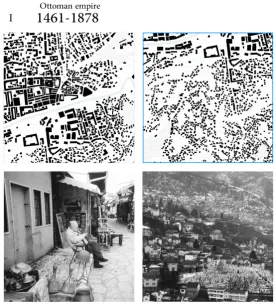
The heritage of the Ottoman Period (1461-1878)
An urban analysis of Sarajevo starts with the Turkish domination, when Isa-Beg Ishaković, Ottoman general and governor of Bosnia, ordered the construction of new buildings around the existing village. The majority of the inhabitants at that time lived around Careva Džamija (Emperor’s Mosque), on the southern banks of the river, on the opposite side to the site where Ishaković decided to build his caravanserai (Prstojević, 1999). As a consequence, the Careva Ćuprija (Emperor’s Bridge) was constructed to join the two river banks. The construction of important buildings in the Bašćaršija (Bazar) (Fig. 2), mainly artisans’ shops and mosques, dates back to 1463. But it was Gazi Husrev-beg who made Sarajevo into the commercial and administrative centre of the sultanate. Between 1530 and 1540, he ordered the construction of many important buildings, typical of Turkish architecture, for the purposes of worship, instruction (for example the madrasa and the library), and public life such as the bezistan (market), a hamam and a clock tower (sahat-kula) (Prstojević, 1999).
Figure 3: The Stari Grad (old town) in plan and image (left column) and the mahala of Širokača in plan and image (right column)
Source (plan and photos): Author, 2018
The heritage of the Austro-Hungarian period (1878-1918)
Ottoman domination ended with the Congress of Berlin in 1878, when the Austro-Hungarian Empire obtained military control over the sultanate, although this continued to be part of Ottoman territory de jure until 1908 (Prstojević, 1999). Architects and engineers, appointed by the Hapsburg Empire to develop a new Bosnian architecture expressing the spirit of the time, flocked to Sarajevo, where an intense westernisation and modernisation, both aesthetic and institutional, was underway. During this period, important urbanistic and infrastructural changes such as the tram, testing ground in 1885 for the Viennese line, together with significant industrial growth (Fig. 2), made the beauty and wealth of Sarajevo a match for other Western European cities. In these years, the city expanded as far as the present day Marijin Dvor district, named after a building built at the end of the 19th century by an Austrian entrepreneur, and the Kovaćići
mahala, home to the Hapsburg aristocracy. The presence of a 12-kilometre tram line strongly influenced the growth of the city, creating a continuous urban agglomerate from Sarajevo to Ilidža, at the western end of the line.
Figure 4: The Austro-Hungarian settlement’s urban form is still visible in the urban layout of the city, as in the public space (Trg oslobođenja – Alija Izetbegović)
Source (plan and photo): Author, 2018
Yugoslavia as a Monarchy and as a Socialist Republic (1918-1990s)
In the years between the two world wars, Bosnia was first part of the Kingdom of Serbs, Croats and Slovenes (1918-1929), then part of the Kingdom of Yugoslavia (1929-45), also known as the First Yugoslavia, and was finally incorporated into the Socialist Federal Republic of Yugoslavia (1945-1992). In the Tito years, Bosnia became the industrial centre of Yugoslavia thanks to its plentiful natural resources. This industrialisation was accompanied by a phase of aggressive urbanization. In Sarajevo, the factories and residential buildings in the new districts of Novi Grad and Novo Sarajevo were constructed and the urban area expanded along the river, giving the city its characteristic longitudinal structure (Fig. 5). The hills around the city were illegally settled by large numbers of workers, who moved from the rural areas of Bosnia, attracted by new work opportunities in the city.
Figure 5: The modernist part of the city in plan and the History Museum of Bosnia & Herzegovina designed by Boris Magaš, in 1963
Source (plan and photo): Author, 2018
The nineties and the inheritance of a tumultuous past (1990s-today)
Under Tito, schools taught that “Yugoslavia has six states, five nations, four languages, three religions, two alphabets, but only one Tito” (Di Meo, 2014). The unification of many diverse elements which Tito managed to achieve, crumbled in 1980 on his death, which occasioned one of the grandest state funerals in history. The end of the Pan-Slavic dream gave way to the ethnic chauvinism and territorial claims on the part of the single states that Tito had succeeded in suppressing by means of an authoritarian and repressive, if also enlightened, dictatorship, and which, in 1991, culminated in ten years of armed conflict: the Yugoslavian war.
On March 1, 1992, the Socialist Republic of Bosnia-Herzegovina held a referendum for independence, following the example of other ex-Yugoslavian countries, namely Slovenia and Croatia. Serbia, the political and military leader of the Socialist Federal Republic did not recognise Bosnia’s vote for independence and mobilised Bosnian-Serb military forces, formed by soldiers from the Yugoslavian Army. The war, which would last for three years, saw ethnic cleansing, genocide and fratricide from all factions in the struggle for power. Not only the population, but also the symbols of their cultures were destroyed. The Bosnian value system came under particular attack and Sarajevo, its “intimate portrait” (Karahasan, 1994) and exemplification of this multicultural and multi-confessional culture, was under siege, as were other “safe-areas”, for 1,395 days. During the siege 11,000 people lost their lives and much of the infrastructure and architectural heritage of the city was destroyed together with its identity and moral dimension.
Figure 6: The new city in the valley in plan and image (left column) and the upper-hill settlements in plan and image (right column)
Source (plan and photo): Author, 2018
displaced people (IDPs), radically transforming the social fabric of the country (Research and Documentation Center, 2007; UNHCR, 2013).
As a result of its rich and troubled history, Sarajevo is a place of fragility and potential. Its historical vicissitudes are reflected precisely in and emphasised by its built form. This complex inheritance has so far been preserved thanks to its inhabitants’ tolerant nature, but is now facing a crisis due to the unsustainable direction that urban development has taken in the twenty years since the end of the armed conflict and to growing social and economic inequality on a national level. The repercussions on the city of the war trauma are evident (Fig. 6). As Bollens (2006) observes: “While physical reconstruction is understood and capable of being measured, social recovery (or the lack of it) is amorphous and not visible”(p. 100). The need for physical reconstruction has been almost entirely met thanks to plentiful international aid. The damage to the social environment and to the population, on the other hand, has received little attention and limited support, a situation that has been aggravated by an institutional limbo and widespread corruption, a heavy burden for one of the poorest countries in the European continent.
Substantial foreign investment, frequently by Arab countries such as Saudi Arabia, Qatar and Kuwait, who are keen to affirm their presence in the region, has radically changed the face of the city. On the ruins of Sarajevo, shopping malls and entertainment centres have been built, while on the surrounding mountains, previously the scene of heavy fighting, deluxe gated communities are being constructed as resorts for wealthy foreign tourists. These interventions make no contribution to their wider urban context and ignore the evident disparity with the local population, whose average wage (850 BAM/ 435 Euros a month) excludes them from this type of offer (Sarajevo Times, WTO, CIA Factbook, 2017). Bosnian architect Amir Vuc Zek observes that:
“The consumerism that quickly entered the Balkans during the transition is the only model for progress. And that shows in the streets: a lot of investment in the architecture of greed, little in the revaluation of the public space” (cited in Stockmans, 2016).
The construction of centres of consumption, following a traditional and ineffectual urban development model, has taken the upper hand. The importance of the creation of spaces for meeting and sharing and the value of existing small-scale commercial activities are underestimated and the need to create a network of support and solidarity in a profoundly divided community ignored.
THE PRESENT
In order to focus more on the object of this research, an approach was adopted which gradually arrived at an in-depth analysis of a complex urban milieu, through the study of its potentials and contradictions. Three macro-themes were identified for study: social and political division, lack of public infrastructure, green spaces and geomorphological risk.
Social and political division
“Ironically, while the war damaged but did not eradicate the multicultural spirit of Sarajevo, the political boundaries drawn to stop the war may over time slowly deplete the city’s ability to spawn cross-ethnic integration and tolerance.”
This political division has slowed down the peace process by confirming ethnic divisions, hindering diplomatic and economic relations between the parts and justifying nationalism and territorial disputes. The IEBL (Fig. 7 and Fig. 8) also emphasises another element which is central to this research, namely the significant gap between urban and rural realities. The border line clearly highlights this difference in the context of Sarajevo, the largest and most important city in the country (with a total population of just over 275,000 inhabitants), which, despite the many contradictions of urban life, is a source of civic pride for its citizens. Sarajevo East, on the other hand, is a suburban area with 60,000 inhabitants, without an urban centre or the services expected of a city and lacking an urban identity, apart from that of being the Eastern part of the capital.
“I don’t really have any need to go there. There was nothing there before, it was just countryside, even in Lukavica there was nothing, it was just a small place. People used to go there just to spend the week-end outside the city” (Bassi, 2013, p. 126).
Figure 7: Canton Sarajevo showing the position of the IEBL, the populations of Sarajevo and East Sarajevo (Istočno Sarajevo), the number of municipalities divided by border and land use
At the time of the siege, the rural inhabitants who arrived in the city, fleeing from their villages, where treated with mistrust by the cosmopolitan Sarajevan whose lifestyle was very different from theirs. This hostility enhanced cultural differences that, prior to the persecutions and genocide of the war, had been insignificant, but which today are reflected in Bosnian society. Schools organised around ethnic differences, a fragmented political system and the importance of ethnic identity.
The lack of a public infrastructure: urbicide
Its natural context has always been both a limitation and a source of pride for the city. In the 1882 land register drawn up by the Austro-Hungarian Empire, as well as built up areas, green areas were classified into seven different uses (Avdagić et al., 2014, p. 10) indicating the wealth and variety of the landscape. The Ottoman inheritance is visible in the city today, for example in its cemeteries, which represent an important part of the existing green spaces. In fact, the cemeteries are designated as ‘Cultural Landscape’ in the urban development plans (Canton plans 2003-2023) and therefore protected, while other public green spaces are nowadays few and far between. This lack, in strong contrast to the obvious abundance in the Hapsburg period, is the result of post-war industrialisation, the constant bombardment and the fight for survival of the population during the siege.
Sarajevo was the scene of what some have called urbicide (Moorcook, 1963; Bogdanović, 1993; Coward, 2008), that is the deliberate, rather than incidental, destruction of the urban fabric as a symbol of its culture. Writing about the destruction of the city of Vukovar during the Croatian war of independence, Bogdanović refers to “city haters” who besieged the city in defence of rurality.
“What I sense deep in the city destroyers’ panic ridden souls is a malicious animus against everything urban, everything urbane, that is, against a complex semantic cluster that includes spirituality, morality, language, taste and style. From the fourteenth century onward the word ‘urbanity’ in most European languages has stood for dignity, sophistication, the unity of thought and word, word and feeling, feeling and action. People who cannot meet its demands find it easier to do away with it altogether” (Bogdanović, 1993, p. 18).
According to Coward, “urbicide is thus the destruction of the city in order to eradicate urbanity itself” (Coward, 2008, p. 37). The attempt to annihilate the symbols of Bosniak culture also targeted the meeting places in the city including the public spaces: the Serb army of the Srpska Republic (VRS) systematically and repeatedly destroyed the green spaces in and around Sarajevo (Pilav, 2012, p. 4). The surrounding mountains were mined – in 2014, 2% of the Bosnian territory was contaminated; a two kilometres tree-lined avenue in Ilidža, created by the Hapsburgs and a symbol of public life, was destroyed; the cemeteries were used as sniper positions.
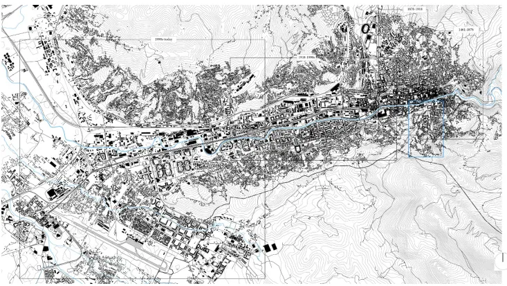
Figure 8: The mahalas of Sarajevo (in blue), the case study of Širokača (rectangle) and the IEBL (black dotted line) in an axonometric view from the South
Geomorphological risk and urban sprawl
The Sarajevo Valley is surrounded by mountains composed of Secondary and Tertiary rocks of dolomitic and calcareous origin. The River Miljacka rises in a karst area and descends 1,000 metres in only 15 kilometres with a 7% gradient, which significantly increases erosion along the banks and the risk of sudden flooding. As it crosses the valley, the river collects runoff from the mountain slopes, which are especially steep and close on its left bank, again increasing its erosive power. The central European continental climate is influenced by the vicinity to the Adriatic Sea which causes frequent precipitation (900 mm a year) and heavy rain (Martin-Diaz et al., 2015, p. 3). Between 13 and 18 May 2014, an area of low pressure brought heavy rain to South East Europe. Three months’ worth of rain fell on the region in three days, causing widespread flooding and landslides. In Bosnia, floodwaters triggered a total of 3,000 landslides. Both flooding and landslides were particularly serious in areas where harmful human activity resulting from a lack of attention to urban development had created unsustainable environmental conditions. Illegal construction on unstable terrain and river banks in the post-conflict period, the creation of infrastructure disregarding the natural context, mining activity undertaken without sufficient scientific controls and a generalised lack of attention to the management of the territory, all contributed to a high-risk situation. In Bosnia-Herzegovina, the damage was estimated at 2.04 billion euros, equivalent to 15% of the country’s GDP and worse than that caused by the war (Hydro-engineering Institute Sarajevo, 2015, p. 8).
This tragic event evidenced the lack of a structured national plan for the prevention and management of geomorphological risk. Subsequently, with the help of foreign aid, plans have been activated both for recovery and with the aim of reducing the vulnerability of the region to future calamities of this nature.
From 2000 to January 2016, a total of 855 landslides were recorded in Sarajevo (Martin-Diaz et al., 2017, p. 2). The exact number during May 2014 is not known, however the factors which contributed to the disaster on a nation-wide scale are all present, and in some cases accentuated, in the capital. The need for long term structured planning is therefore evident.
THE MAHALAS. A PARADIGM OF PERI-URBAN SETTLEMENTS
The Mahalas and the upper-hill settlements
The mahalas, the focus of this research, are settlements dating back to the Turkish sultanate and are characteristic of Bosnian cities. Dušan Grabrijan and Juraj Neidhardt (1957) describe their development in detail in their book The Architecture of Bosnia and the way towards modernity. Neidhardt (1901-1979), who collaborated with Le Corbusier (1887-1965) and was one of principal exponents of the rationalist movement in the Balkans, and Grabrijan analyse numerous examples of the functional and architectural elements of the Bosnian house. Part of their research focuses on the principles of urban form on which the construction of the mahalas is based.
The form of these settlements was regulated by a precise hierarchy of streets and by their studied relationship to the topography. The kitchma, the gently sloping main street of the mahala, had several smaller winding streets branching off it, known as sokak, which followed the contours of the slope. The sokak were joined to each other vertically, by long pathways and steps which give access along the chikme to the individual houses. The width of each street type depended on its function, which was normally defined by the number of animals accompanying the user. The streets created a vertical and horizonal step-like stratification of the houses so that no house obstructed its neighbours’ view of the city or relationship with nature. The public buildings were situated at the crossroads between th kitchma and the sokak, distributed in such a way as to serve the whole village. At the centre of the settlement was the fountain, or chesma, the meeting place around which the life of the community revolved. Similarly to Arab and oriental architecture, the element of water was fundamental in the design of landscape and public places.
Bearing in mind Karahasan’s vision, the dramatic system is explicit in the built form of the city, in the relationship between its parts and in its organisation. As previously described, the Baščaršija, hub of the urban fabric and public life, has a two-fold protective “shell” formed by the mountains and the mahalas. It is therefore “technically closed, but semantically open” and contains all the activities and customs of its inhabitants in a “universal” manner. The mahalas, a permeable border with the natural environment and places of private life, are by contrast “technically open, but semantically closed”, each containing their own distinct element, separate from the city centre and expressed in a “particular” manner. Within the mahalas, the open/closed, internal/external dynamic is revealed in their relationship with the city and in the distribution of their spaces. The house, or kuća, faces the city and is therefore semantically open, but, at the same time, it is closed from the road by high walls. The other façade of the house is, instead, semantically closed to public life, but with gardens and courtyards physically open to nature. This dual relationship is also seen in the spaces which act as a filter between the inside and the outside of the dwellings: loggias, verandas, courtyards, divhana and doksat, windows similar to modern bow windows, jutting out on the second floor and overhanging the street, which form a rich and dynamic space between exterior and interior, typical of Oriental architecture.
The mahalas, once a master piece of context driven urban design, whose organisation was rooted in a strong sense of public life, have today almost completely lost their previous beauty and uniqueness.
The rapid urbanisation since World War II, which according to Hamilton (cited in Martin-Diaz, 2017, p. 3) was the fastest in the Western Balkans, brought thousands of workers from the rural areas of Bosnia to the capital. Urban growth in socialist Yugoslavia was based on the principle of equality of access to housing, which was state-controlled. The property market saw several reforms which created a mixed system, halfway between socialist and capitalist, and left housing in the hands of a few business concerns who gave priority to their workers. In this way, the private sector played an important role in urbanisation and created an imbalance at a national level between the overall and private property market. This was not however the case in Sarajevo, where, as in other large urban agglomerations, the state offer maintained its advantage, relegating private construction to those who had no other alternative. Construction was concentrated in areas assigned to medium and low-density housing on the slopes around the city and on flat land to the west of the city.
demand for housing. The traditional housing practices of rural migrants and uncertainty in the allocation of social housing further exacerbated this situation. According to Martin-Diaz et al. (2017, p. 3), new constructions were of three types: legal, illegal but conforming with zoning regulations, illegal and non-conforming to zoning regulations. This latter case included construction on state owned forested areas lacking urban services and subject to hydrogeological risk. Despite these risks, the low cost of hill land and the fact that many industries were located at the foot of the mountains, and therefore easily accessible to workers housed on the slopes, meant the hills were gradually built up.
During the seventies, some attempts were made to halt this sprawl, but the project failed in the face of a lack of resources and the complexity of the necessary measures. The mahalas were overwhelmed by the new development which continued to spread to very steep and instable areas. As previously explained, during the Bosnian war, large numbers of people fled from the rural areas, particularly from Eastern Bosnia, and found refuge in the besieged capital. These forced migrations, together with the territorial division along ethnic lines following the Dayton Peace Agreements, modified the urban form. Unable to return to their homes for fear of persecution, psychological trauma and bureaucratic obstacles, the IDP occupied the only terrain still available to them – the peri-urban slopes around the city. The mahalas lost the quality of their landscape and their architectural identity and even lost their name: the ‘upper-hill settlements’ were born. In the Canton of Sarajevo, 47% of constructions are classified as unauthorised (Nurkovic, 2016, p. 8). A large part of these constructions are in the Sarajevo Valley, where between 25,000 and 50,000 illegal buildings are located on high-risk terrains (Martin-Diaz et al., 2015, p. 6), with the highest concentrations in Aneks, Pofalići, and Vraca.
The case of Širokača
The characteristic strengths and weaknesses of the mahalas are common to all of them. For the purposes of this study, Širokača was chosen as exemplifying all those peri-urban communities whose shared morphological and historical features make each an “intimate portrait” (Karahasan, 1994) of the whole. The three themes previously discussed at the city level can be analysed in depth at the neighbourhood level, considering the experience of Širokača as paradigmatic of the mahalas in general.
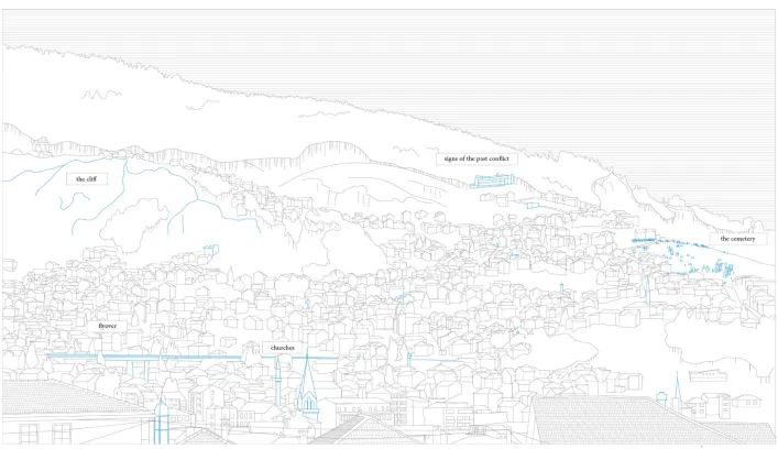
Širokača lies on the northern slopes of Mount Trebević, at an altitude of between 600 and 900 metres above sea level. These slopes are in places very steep and a cliff runs through the centre of the mahala, dividing it into two parts, with a difference in altitude of over 100 metres (Fig. 9) The cliff is bordered by two streets (ulica in Serbo-Croat), called Džeka e Bostarići. Several streams run through the neighbourhood, the largest of these, Bistrik Potok, rises at the highest point of the mahala and runs towards the valley at the foot of the cliff before being covered by the street, which gives access to the mahala Bistrik ulica. In the absence of official documents describing the settlement of Širokača, various resources have been consulted in an attempt to create its inhabitants’ profile.
Širokača is not one of the mahalas with the highest population density, neither does it have the highest concentration of high-risk constructions, it was instead chosen as a case study for its historical value, because of its rural nature, its accentuated topography and its position close to both the Stari Grad, the old town, centre of services and cultural heritage, and to the IEBL, semantic location of the process of division.
Social and Political division: a brief history of Širokača
The origins of the mahala are closely connected to the Bistrik neighbourhood, immediately below it, which is one of the oldest in the city. Bistrik originally grew towards the slopes of Mount Trebević, following Ottoman principles, which can still be seen in the road plan, but this organisation was soon replaced by the characteristics of upper-hill settlements. In the same way, the mahala lost its historical identity. Like all the mahalas, Širokača was hard hit by the ethnic and social upheavals caused by the war. The arrival of new inhabitants modified the social dynamics of the neighbourhood and lead to hostility between the IDPs and the citizens of Sarajevo, between rural and urban realities.
During the siege, the position of the Serb front line changed continually and Širokača was the scene of some of the heaviest fighting, due to its strategic position in defence of the old town. Mušan “Caco” Topalović, one of the notorious war-lords, ex-criminals who defended the city during the siege, set up defences in Širokača, while Mount Trebević became a mine-field, occupied by the sniper position of the Bosnian-Serb forces (Sacco, 2003, p. 39). Because of its symbolic value, Bistrik was extensively damaged and danger entered Širokača. Although the fighting is long past, this feeling remains today in its relationship with nature and the mountain. The mountain itself, once a place of recreation, became a no-man’s land. Borelli states that this state of abandon was not due to a lack of funds, but rather to a lack of political will (Borelli, 2011). The mine fields have not yet been completely cleared, the sports facilities and, with one exception, the hotels and restaurants have not been rebuilt and the cable car has only recently been reopened. The geographical violence that lead to the creation of the IEBL and the accompanying politics of division changed the connotations of Trebević, no longer a sacred place enjoyed by the citizens of Sarajevo.
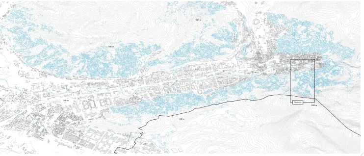
Hydrogeological risk
has a gradient above 15%, with construction spreading over time to gradients of more than 30%. The data illustrates the interconnection between urban development, forced migration, and hydrogeological risk.
Public infrastructure
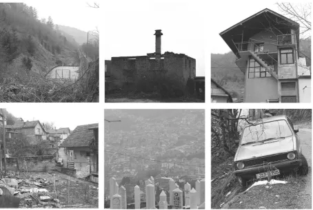
Širokača is almost exclusively residential. 25% of its built fabric is in a state of decay (Fig. 10) and abandon and in need of renewal. The few public structures, apart from religious buildings, consist of three small commercial activities, a pharmacy and a primary school. Nearby, Bistrik has more services including sports facilities, administrative offices (including the Ministry of Defence) and tourist accommodation due to the vicinity of the Baščaršija. The residents of Širokača are therefore forced to go down valley for their needs. As far as open spaces are concerned, the mahala is totally lacking in meeting places or play areas apart from one sports field – the only public facility for 4,000 users. The streets have no pavement for pedestrian use and there are no footpaths in the area. The illumination of public spaces is limited and inadequate. Despite the surrounding mountainous natural context, green spaces are inaccessible, unequipped and apparently of no public interest.
At the same time, the availability of open space, the wide views and the rural nature of the location offer great potential for improvement.
Figure 10: The mahala of Širokača. Examples of analysed elements within the built fabric and the natural environment
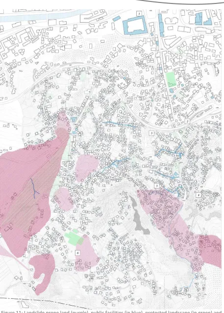
Figure 11: Landslide prone land (purple), public facilities (in blue), protected landscape (in green) and roads subject to future improvement (in blue) in Širokača. The numbers refer to design elements which
RESULTS AND DISCUSSION. GUIDING PRINCIPLES AND STRATEGIES
The SarajlijeSarajevo is a small city. After spending time in Sarajevo and Bosnia, it becomes apparent to the visitor that the perception of the former depends on its cultural system rather than on its variegated formal aspect, which is instead an expression of the latter. From an architectural point of view, this is particularly evident in the mahalas. Haidar et al. (2006) describes the characteristic construction “in reinforced concrete with brick partitions and without any outer covering. Often the vertical elevation is completed in several stages, according to the economic means of the owner” (p. 130), a style which Skotte (2004) defines as Yugoslav vernacular and which is found throughout rural Bosnia.
Reproposed in the context of Sarajevo, this building style is an expression of complexity (and inequality) which, as Boano (2017) observes, is “not specific to a geographical location, but is rather a way of approaching urban life”.
The urban morphology of the mahalas is similar to that of informal settlements in Latin America, Asia or Africa. Though freed from the extreme economic and climatic conditions that influence such communities, the mahalas are the expression of the same ability to create an environment that is both personal and functional and which involves the adoption of a variety of innovative and informal solutions independently of more structured systems. This type of resilience, in Sarajevo and throughout the Balkans, is in strong contrast to other parts of Europe, geographically close but culturally distant.
Sarajevo offers many opportunities for urban research, which has most frequently focused on large scale empty spaces, suburban sites abandoned after rapid urbanisation, and the interstices between one residential block and another. This study instead chooses to work on and for the hill settlements with the aim of giving value to these neglected suburbs with their characteristics of forced settlement and inadequate terrain, which have been largely ignored in the recent debate on the city’s development. The study aims to focus interest on the mahalas, both in terms of the problems they face and of the potential they possess, in the context of a city which has always shown great resilience. The adaptability and courage (or perseverance) of the Sarajlije is the starting point and inspiration of this project and for the strategies it proposes for the development of the community and autonomous economic practices. Such a complex reality requires a pattern of intervention that is highly adaptable and recognises the versatility and ingenuity of existing survival strategies as the basis for the process of reconstruction in the community.
Memory
D. Rieff (2016) asks if the creation of a collective memory is necessary when, by its very nature as a social construct, it is deformed according to the meaning society chooses to attribute it: “[…] when collective memory condemns communities to feel the pain of their historical wounds and the bitterness of their historical grievances […] it is not the duty to remember but a duty to forget that should be honoured” (Rieff, 2016, p. 121). This study adopts Rieff’s argument, according to which the non-valorisation of the collective memory is an intellectual operation necessary for reconciliation in the community. Haidar et al. (2006) states that “The opportunity to inhabit a city without ghosts and shadows depends on this condition, which enables people to choose afresh their own urban dimension” (p. 110).
reality shaped by the trauma of conflict. Or rather, what is the legacy, both urban and social, of urbicide, of the distortion of landscape and the creation of “traumascape” (Tumarkin, 2005). Sarajevo is in fact a city that has preferred the oblivion of memory to the re-invention of meaning for the places which acquired negative connotations during the siege. Examples of the new identity assumed by meeting places are found in the process of unremembering of Mount Trebević or of the suburbs of Ilidža.
S. Barakat defines reconstruction as “a peaceful environment that prevents a relapse into violence” (Barakat, 2010, p. 11). This “environment” may be understood not as a physical space, but as a condition of socialisation: the renewal of places of collectiveness without their physical reconstruction. The creation of new layers of significance overlaying the remains of war gives new meaning to practices of resilience, thus turning an outcome of trauma into a positive practice, without recreating the physical spaces in which this trauma occurred.
Three guiding principles
The adaptability of the Sarajlije and the importance of memory are thus the point of departure of the project, from which its main objectives and related strategic actions develop. Three guiding principles governing the project can be identified.
The ‘scattered’ approach; the pathway of facilities
Širokača, while not particularly densely settled, is one of the largest mahalas in the city. In order to intervene in an area of this size the idea of a project pathway or “spine” ascending (and descending) the slope, joining the valley to the upper hillside and distributing services in a precise but scattered manner, involving the whole area, was devised (Fig. 11). The pathway also aims to provide a focal point in a divided reality by reducing the distance between different spaces and diverse concerns. The language of composition is clear and unambiguous, but also allows variety and freedom.
The pathway gives the project its overall identity, which is expressed in a variety of forms and in various places. The distribution of small and medium-scale interventions over a wide area (Fig. 12) means that their overall influence is enhanced while pre-existing forms are respected in order to maximise cost-benefit ratios. In a context rich in meaning but poor in economic terms like Sarajevo, this is obviously indispensable.
Bottom-up initiatives
Although the concept of participation has been much debated and contradicted in the world of architecture, it is indisputably a fundamental rationale of this project, which takes advantage of the existing network of relations in a peri-urban community in order to create bottom-up initiatives aimed at the reconstruction of a fragmented and divided social fabric. The involvement of the community in the creation of their public spaces aims at strengthening the bond among its members and at restoring a spirit of place. The sought-after effect of this participatory approach would be achieved through awareness-raising campaigns, an inclusive methodology for the fair distribution of public space and delivery of basic services, and new economic and social possibilities that are implemented through the proposed strategic actions.
Urban resilience
streets to protect pedestrians from the sight line of the snipers; all green spaces were used for allotments; houses were rigged up with the DIY tools necessary for everyday life.
Such survival techniques have been amply studied and accounts make fascinating reading, however it is important to underline that this study does not propose to readopt strategies used in desperation in order to survive an emergency, but rather to gain inspiration from the spirit of inventiveness in order to generate innovative solutions. The intention is to purge such practices of resilience of any remaining negative connotations and give them new meaning. A process of trust building in the community and the belief in the possibilities of “build it yourself” (Ward, 1976) is also central to the project’s spirit.
STRATEGY
The project revolves around four types of action, each of which is a response to the needs identified and to the problems analysed and correspond to the objectives that have been established, namely reduce, reconnect, reactivate, and resettle.
Reduce
The first typology of intervention involves the reduction of hydrogeological risk, combined with the creation of a local network of peri-urban agriculture. The rural characteristics of the area and the presence of small cultivated plots between the houses in Širokača suggest that setting up a more organised system of allotments is appropriate. In order to create such a system on the mountainside, a gradual process of levelling is necessary; as well as enabling cultivation, this operation also consolidates the surface of the terrain.
Aside from bringing food into the household, peri-urban farming activities can improve income possibilities and may be relevant in terms of community empowerment and inter-ethnic reconciliation. Evidence shows that urban and peri-urban farming “can play a critical role in helping the world’s urban poor by providing a practical solution to the food crisis in the shorter term, and by providing a climate change adaptation mechanism in the longer term” (El Bilali et al., 2013, p. 1604). However, currently, at an institutional level, there is little interest in urban farming in Bosnia & Herzegovina and any initiatives depend on the few NGOs active in this sector.
Reconnect
The second type of action includes a series of interventions at the level of public space that form a pathway designed to create shared meeting places in order to foster a sense of community. Reconnection is therefore a physical process, the mending of a fragmented urban fabric, and a psychological change in the individual’s position within the community. Reconnection also involves the historical tie between the citizen and nature, interrupted by urbanisation and war and reproposed here at the neighbourhood scale.
Reactivate
Figure 12: Some examples of the designed spaces and interventions: public facilities around a pocket square and the repurposing and new accessibility of the stream, as a new public green space
Resettle
The housing problem in Sarajevo is particularly felt due to the problem of landslide risk on the one hand and to the as yet unresolved consequences of the war on the other. As a response to the latter, several resettlement programmes have been set up by national organisations (Federal Ministry of Displaced Persons and Refugees, Regional Housing Programme) and international bodies (Hilfswerk, UNHCR, 2013).
The housing solution proposed in this project, which can be reproduced in all similar contexts, is the creation of housing developments in geomorphologic risk-free zones within existing neighbourhoods, in order to resettle local residents and post-’95 returnees. Other weak members of the population, who are not at present considered high priority in rehousing programmes, are included in this housing solution: the elderly, young couples, single or new families.
The overall dynamic of the facilities pathway (Fig. 11) is a function of the interaction of numerous locations which can be exemplified by three focal points of the project. The first hub is the housing development together with the workshop (Fig. 12). The second focus is a cultivated area which combines risk prevention and social interaction. The third example demonstrates the relationships created between public spaces and their natural or built context (Fig. 13). The precise identity of the project lies both in each individual small-scale intervention and in the ascending or descending pathway which they create as a whole
Postscript
On the mountainside above Širokača, a war-damaged derelict construction is visible (Fig. 14). This building is administratively under the jurisdiction of the Republika Srpska and as such is outside the range of any intervention in the mahala. Whatever improvements may be done in Širokača, this sign of past conflict cannot be eradicated, hampering the project’s vision and its effectiveness in terms of reconciliation. This demonstrates how the boundary line’s grey area effects the perception of space and conditions urban planning and design in Sarajevo. The crucial issue of administrative division can only be resolved through diplomatic discussions between the sides.
Figure 14: War-damaged building in Šumarska ulica, above Širokača, on Republika Srpska side of the IEBL
CONCLUSIONS. RESILIENCE AND RECONCILIATION
“The language in which I think, in which I feel, in which I live and in which I experience the world, has been reduced to a tool for the creation of misunderstanding” (Karahasan, 1994, p. 14) The themes of this project are part of a wider reflection on the city in a moment of a delicate post-war post-reconstruction transition. Sarajevo, half-way house between West and East, is a bridge between the two worlds and a place where it is still possible to re-imagine both. Although the future may seem bleak, alternative scenarios are still attainable.
In recognising the strengths and weaknesses of the Bosnian capital and in particular of the mahalas, with their problematic relationship between morphology, history and settlement, the Širokača project is rooted in the everyday experience of the neighbourhood. It seeks to improve the relationship between the city and its citizens through bottom up participatory strategies and scattered small-scale architectural interventions.
Each individual operation in the proposed pathway shares and expresses the same underlying objectives as the entire project, which in turn can be reproduced at the macro-level of an urban system which possesses the same nature as its parts.
The results of recent investment from the Gulf States and the recent growth of international tourism are evident in the ostentatious new developments in and around Sarajevo. Fostering strong local communities is a possible antidote to the loss of identity which these changes, coupled with post-war demographic shifts, are likely to bring. The implementation of pathways of small-scale architectural interventions, such as those proposed in this work, could serve as a means to kick-start a necessary process of urban reactivation.
The potential of a peri-urban context, the economic constraints and the informal character of the mahalas are symptoms of an urban development in need of regulation and direction towards a more equal future. Their latent urban resilience, which is both inspiration and instrument of this project, is a resource for the creation of a network of mutual help and sustainable mechanisms which are not only physically tangible, but also social.
A situation of pressing and genuine need may also have lessons to teach to more stable and democratic cities, with more peaceful histories.
REFERENCES
AGENCY FOR STATISTICS OF BOSNIA and HERZEGOVINA (2013). Census of Population, Households and Dwellings in
Bosnia & Herzegovina. Final Results. Retrieved 16 February 2019 from:
http://www.popis.gov.ba/popis2013/doc/RezultatiPopisa_BS.pdf
AVDAGIĆ, A., BEĆIROVIĆ, D., HAJRUDINOVIĆ, A., HUKIĆ, E., KRPO, M., MARIĆ, B., MUTABDŽIJA, S., OMANOVIĆ, M.,
PINTARIĆ-AVDAGIĆ, B. & SALIHOVIĆ, A. (2014). Landscapes of Sarajevo Region LE:NOTRE Extraordinary
Landscape Forum Sarajevo. Retrieved 16 February 2019, from
https://it.scribd.com/document/288024121/Sarajevo-s-Landscape-First-Look-20140417
BARAKAT, S. (2005). After the Conflict: Reconstruction and Development in the Aftermath of War. London: I.B.Tauris. BASSI, E. (2013). Sarajevo: Divided or Redoubled? Regulations Representations and Practices across the Boundary.
Ph.D. Thesis University of Milan, Biccoca. Retrieved 16 February 2018, from
https://boa.unimib.it/handle/10281/46089
BOANO, C. (2017). Fragility and Potential across the Global South. Lecture at Dipartimento di Architettura di Ferrara,
BOGDANOVIĆ, B. (1993). The Ritual Murder of the City. The New York Review of Books 40(10), Retrieved 17 February 2018, from http://www.nybooks.com/articles/1993/05/27/murder-of-the-city/
BOLLENS, S.A. (2006). Urban Planning and Peace Building. Progress in Planning, 66(2), 67-139.
BORELLI, C. (2011). Leftovers of History. The Forgotten Heritage of Mount Trebvić. Social Anthropology, Department of Anthropology and History of America and Africa, University of Barcelona (Spain), CICOP 4th H&hM Conference Sarajevo: “The importance of place”. Retrieved 16 February 2018, from http://www.academia.edu/1292957/The_leftovers_of_history._The_forgotten_heritage_of_Mount_Trebevi c_Sarajevo_
CIA WORLD FACTBOOK: https://www.cia.gov/library/publications/the-world-factbook/geos/bk.html COWARD, M. (2008). Urbicide. The Politics of Urban Destruction. London: Routledge.
DE FERREIRO, M.F., SANTOS, S., COSTA, P., COSTA PINTO, T. & COLAÇO, C. (2016). Socio-Economy of Peri-Urban Areas: The Case of Lisbon Metropolitan Area. In Maheshwari, B., Singh, V. & Thoradeniya, B. (eds.), Balanced Urban Development: Options and Strategies for Liveable Cities. Water Science and Technology Library, vol 72 (pp. 111-121). Cham: Springer.
DI MEO, A. (2014). Gli Anni di Rosa. Lampi di Stampa.
DISPLACEMENT TRACKING MATRIX (DTM): https://displacement.iom.int/bosnia-herzegovina
EL BILALI, H., BERJAN, S., SIMIC, J., DESPOTOVIC, A., CADRO, S. & KULINA, M. (2013). Urban and Peri-urban Agriculture in Sarajevo Region: An Exploratory Study. Journal of Central European Agriculture, 14(4), 1585-1597. GRABRIJAN, D. & NEIDHARDT, J. (1957). Arhitektura Bosne i put u savremeno [Architecture of Bosnia and the Way
Modernity]. Ljubljana: CZP.
HAIDAR, M., CIPOLLINI, L. & KOSSEL, E. (2006). Città e memoria: Beirut, Sarajevo e Berlino. Milano: Mondadori Bruno. HILFSWERK INTERNATIONAL: http://www.hilfswerk.at/international/en/
HYDRO-ENGINEERING INSTITUTE SARAJEVO (2015). Floods and Landslides Risk Assessment for the Housing Sector in Bosnia and Herzegovina. EU Floods Recovery Programme. Retrieved 16 February 2018, from http://www.ba.undp.org/content/bosnia_and_herzegovina/en/home/library/response-to-floods/flood-and-landslide-risk-assessment-for-the-housing-sector-in-bi.html
INTERNATIONAL LABOUR ORGANISATION:
https://www.ilo.org/ilostat/faces/oracle/webcenter/portalapp/pagehierarchy/Page21.jspx KARAHASAN, D. (1994). Sarajevo: Exodus of a City. Kodansha USA Inc.
MARTIN-DIAZ, J., NOFRE, J., OLIVA, M. & PALMA, P. (2015). Towards an Unsustainable Urban Development in Post-war Sarajevo. Area, 47(4), 376-385.
MARTIN-DIAZ, J., PALMA, P., GOLIJANINC, J., NOFRE, J., OLIVA, M. & ČENGIĆE, N. (2017). The Urbanisation on the Slopes of Sarajevo and the Rise of Geomorphological Hazards during the Post-War Period. Cities, 72(A), 60-69. MATICA BOSNIA AND HERZEGOVINA: http://www.matica-bih.org
MOISSIDIS, A. (2008). Peri‐Urban Rural Areas in Greece: The Case of Attica. Sociologia Ruralis, 37(2), 228-239. MOORCOOK, M. (1963). Dead God’s Homecoming. Science Fantasy, 59.
NARDELLI, A., DZIDIC, D. & JUKIC, E. (2014). Bosnia and Herzegovina: The World’s Most Complicated System of
Government. The Guardian, 8 October. Retrieved 18 February 2018, from
https://www.theguardian.com/news/datablog/2014/oct/08/bosnia-herzegovina-elections-the-worlds-most-complicated-system-of-government
NURKOVIC, R. (2016). The City of Sarajevo as the Focal Point of the Development of Spatial Planning. University of
Sarajevo. Retrieved 18 February 2018, from
https://pdfs.semanticscholar.org/fab0/928fe29b94618079b76e605c3a9fadd14a43.pdf
PILAV, A. (2012). Before the War, War, after the War: Urban Imageries for Urban Resilience. International Journal of Disaster Risk Science, 3(1), 23-37.
REGIONAL HOUSING PROGRAMME: http://www.regionalhousingprogramme.org/bosnia-and-herzegovina/
RESEARCH AND DOCUMENTATION CENTER (2007). Casualties Research Result. Retrieved 17 February 2018, from
https://web.archive.org/web/20070801000000*/http://www.idc.org.ba/prezentacija/Bosna%20i%20Herce govina.zip
RIEFF, D. (2016). In Praise of Forgetting: Historical Memory and Its Ironies. New Haven & London: Yale University Press.
SACCO, J. (2003). The Fixer – A Story from Sarajevo. Montreal: Drawn & Quarterly. SARAJEVO TIMES: https://www.sarajevotimes.com/average-salary-bih/
SIMEUNCEVIĆ RADULOVIĆ, S., MITROVIĆ, B., RALEVIĆ, M. & ÐUROVIĆ, M. (2012). Informal Growth of Housing in Belgrade under the Impact of Transition to Global Economy. Cities to be tamed? Standards and Alternatives in the Transformation on the Urban South 15-17 November 2012, Milan. Retrieved 24 February 2018, from http://www.planum.net/download/ctbt2012-simeun-evi-radulovi-et-al-section1
SKOTTE, H. (2004). Tents in Concrete. What Internationally Funded Housing Does to Support Recovery in Areas
Affected by War; The Case of Bosnia-Herzegovina. NTNU Trondheim.
STOCKMANS, P. (2016). Wealthy Arabs Buy up Sarajevo. MO* Mondial Nieuws. Retrieved 16 February 2018, from https://www.mo.be/en/report/wealthy-arabs-buy-sarajevo
TUMARKIN, M. (2005). Traumascapes: The Power and Fate of Places Transformed by Tragedy. City: Melbourne
Publishing.
UNHCR Global Appeal (2013). Bosnia-Herzegovina (Refugees and Displacement). Retrieved 17 February 2018, from http://www.unhcr.org/publications/fundraising/4ec23109a/unhcr-global-appeal-2012-2013-bosnia-herzegovina.html
UNITED NATIONS DEVELOPMENT PROGRAMME: http://hdr.undp.org/en/composite/HDI
UNITED STATES OF AMERICA DEPARTMENT OF COMMERCE (2017). BiH 2017 Country Commercial Guide, Retrieved 17 February 2018, from https://ba.usembassy.gov/business/
WARD, C. (1976). Housing: An Anarchist Approach. Retrieved 17 February 2018, from
https://it.scribd.com/doc/77447470/.
WIRTH, L. (1938). Urbanism as a Way of Life. The American Journal of Sociology, 44(1), 1-24. WORLD BANK: https://www.doingbusiness.org/en/reports/global-reports/doing-business-2017
ZAVOD ZA PLANIRANJE RAZVOJA KANTON SARAJEVO [Institute for Development Planning Sarajevo Canton] (2006). Prostorni plan Kantona Sarajevo za period od 2003 do 2023 godine. [Spatial Plan of Canton Sarajevo for the
period from 2003 to 2023], Retrieved 16 February 2018, from