1347
A STUDY ON ADVANCED RAM ALERT GENERATION
ALGORITHM USING AIRCRAFT NAVIGATIONAL
INFORMATION
1Seoung-Hyeon Lee
1Information Security Research Division, ETRI, Daejeon, Korea
E-mail: 1[email protected]
ABSTRACT
The next-generation air traffic control system has advanced in a way that directs safely as many aircraft as possible in the limited airspace to meet rapidly increasing demands for air traffic. PBN is a navigation method recently released by ICAO to combine RNAV and RNP. As airspace capacity increased owing to the relaxation of the aircraft separation standards and the shortest routes between fixed points (or waypoints) that aircraft pass through were connected, the general flight distance and time have been reduced. PBN requires accuracy in the measurement of aircraft positions and flight route calculation for effective air traffic control. ADS-B sensor is a core component of PBN. ADS-B sensor data generated based on the GPS, the accurate information on the aircraft include a like position, altitude and direction, the generated data and transmits to the ground. In the existing air traffic control system, the position of the aircraft, which is measured by PSR has a lot of errors. Therefore, it has allowed a significant error rate in distance measurement and RAM centered on the aircraft to use the position of the aircraft. Fusion track data to be used in the next-generation air traffic control system utilizes the track data that combines PSR track and ADS-B sensor data, it can calculate the accurate position of the aircraft. In this paper, I proposed the accurate aircraft the distance measuring method and applying the measured result in the RAM using the fusion data track. First, for accurate position measurement and monitoring of aircraft on an allocated route, a virtual aircraft position on a route is mapped in reference to rectangular coordinates with straight lines and aircraft position. Second, the distance between two points is calculated by means of a Vincenty formula algorithm, and the calculation result is utilized for aircraft conformance monitoring. When the method proposed in this paper is applied, it is possible to reduce the separation gap of an aircraft for more accurate aircraft position measurement, and a safe navigation of aircraft as much as possible in the limited airspace is guaranteed. Also proposed a method for secure transmitting aircraft safety information to a controller or an external system using a physical unidirectional transmission method.
Keywords: Vincenty formula, ADS-B, Fusion Track, RAM, UNIWAY
1. INTRODUCTION
According to studies conducted in the U.S. and Europe, the increase of air traffic cannot be readily addressed only by improving the aircraft performance and ground facilities. To handle the drastically increasing air traffic, ICAO (International Civil Aviation Organization) has conducted innovative air navigation procedures and technology developments [1-2]. To meet such requirements, the next-generation air traffic control system of CNS/ATM (Communication, Navigation, Surveillance/Air Traffic Management) utilizes artificial satellites, ADS-B (Automatic Dependent Surveillance-Broadcast) sensors, and data communication technologies to secure safety in aircraft navigation [3]. In addition, a new
1348 develop and apply the next-generation air traffic control system by the year of 2020 [7]. For CNS/ATM and PBN methods too, however, the role of the air traffic control system and air traffic controller is of great importance in order to secure the safe navigation of aircraft by predicting and controlling aircraft traffic based on the accurate monitoring information and flight plans. Besides, it will take a long time for the existing navigation facilities to be replaced to meet the requirements of CNS/ATM. Hence, it would be an effective way to improve the existing air traffic control system by minimizing the separation gap between aircraft so that as many aircraft as possible can be operated safely in limited airspace unless it hinders the safety navigation of an aircraft [8-9].
Currently, the most effective method, those using the fusion track data combines ADS-B sensor data and PSR data, calculating a more accurate position of aircraft is used to calculated results to the air traffic control system.
In this paper, I proposed the accurate aircraft the distance measuring method and applying the measured result in the RAM (Route Adherence Monitoring) using the fusion data track. For accurate end-to-end distance measurement, this paper adopts Vincenty formula algorithm. A rectangular coordinate calculation method for RAM is used to improve the performance compared to that of existing methods. In addition, aircraft safety information should be protected from external hacking threats.
The composition of this paper is as follows. In Chapter 2, I explained the method applied in the existing air traffic control system and the method to apply in this paper. In Chapter 3, I analyzed the problems of the existing methods and proposed a method to reduce the aircraft separation interval. In Chapter 4, the proposed method is applied to predict the flight path of the aircraft. In addition, simulation results for a method of generating a safety alarm by comparing the actual route of the aircraft with the predicted route are described. Also, I analyzed the accuracy of the great circle method and the Vincenty formula method. In Chapter 5, I proposed a method to protect the air traffic control system from external hacking threats. Finally, I concluded in Chapter 6.
2. RELATED WORK 2.1 ADS-B Data
ADS-B is the next-generation surveillance system of CNS/ATM that allows the sharing of aircraft information, such as position, altitude, etc.,
among aircrafts and ATC (Air Traffic Control). ADS-B features higher accuracy of identification than current PSR (Primary Surveillance Radar) provides because GPS (Global Positioning System) is used in the acquisition of the aircraft position. Therefore, superior air traffic control featuring the higher degree of accuracy, safety, and efficiency is possible in a controlled airspace [10–12]. The ADS-B data format is as follows.
Airborne Position
Pressure Altitude
Surface Position
Velocity
Aircraft Identification and Type
Emergency Information
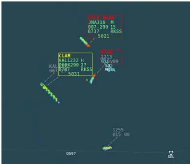
Fusion track data is obtained by fusion of figure 1 (ADS-B sensor data) and figure 2 (PSR and SSR (Secondary Surveillance Radar) data), the air traffic control information includes the accurate position of aircraft and identification information.
[image:2.612.318.516.357.519.2]Figure 1: ADS-B Data Display
[image:2.612.320.514.547.715.2]1349
2.2 A Method Of Calculating Geographical Distance
Geographical distance means the distance between two coordinates on earth that are referred by latitude and longitude. In order to make sure the safe and efficient flight, air traffic management system requires a variety of point-to-point distance calculations such as between aircraft, aircraft and waypoint and between waypoints.
2.2.1 A Method Of Distance Calculation Using Great-Circle
Aircraft or ship travels the shortest route that demands the minimum fuel consumption and travel time for economic reasons. Great-circle algorithm is used to calculate the shortest distance connecting the two points on the coordinate [13-14].
The shortest distance between two points on coordinate always include great-circle since the earth’s surface similar to the sphere and the shortest distance connecting the two points is the shortest distance between two arcs. Great-circle means the largest circle of cut surface if the sphere is cut in two, if the radius of sphere is r, the radius of
great-circle is also an r. Therefore, in order to travel
between the two points on coordinate through the shortest distance, one must choose great-circle route.
2.2.2 A Method Of Distance Calculation Using Vincenty Formula
Great-circle calculates the shortest distance between the two points on coordinate by assuming the earth as a sphere. However, the earth is not actually a sphere but of an ellipsoid, comprises irregular surface and therefore in reality, it has significant error in the calculation of the shortest distance. Vincenty formula is an algorithm that was developed by Thaddeus Vincenty in 1975: it calculates the shortest distance between the two points on coordinate by defining the earth as a rotational ellipsoid. Vincenty formula is suitable for geographical calculation since it is accurate within the error rate of 0.5mm (0.020”), but is not generally used by air traffic management system since it requires a lot of computation compared to great-circle [15-16].
Vincenty formula algorithm has two methods to solve inverse problem and direct problem. Vincenty inverse formula a method to calculate distance and direction or azimuth between the two points on coordinates when latitude/longitude between the two points are given. Vincenty direct formula a method to calculate
latitude/longitude of another point on coordinates when latitude/longitude of a point on coordinate and direction of azimuth are given. Vincenty inverse formula algorithm was applied in this paper.
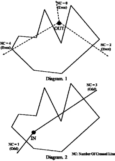
2.3 A Method Of Determining The Position Within A Volume using PIP
[image:3.612.318.513.256.528.2]PIP (Point In Polygon) is an algorithm that determines if a point is located within the polygon [17]. Figure 3 shows an example of determining if a point is located within the polygon by means of PIP algorithm.
Figure 3: A Way To Determine If A Point Is Located Within The Polygon
1350
3. PROPOSED METHODS 3.1 Problems of Existing Method
3.1.1 Problems of the use of Greate-Circle
Great-circle algorithm calculates the distance based on great-circle, which is a circular arc that connects two points and makes the shortest path on the assumption that the earth is a complete sphere. A path of great-circle is useful in calculating the shortest intercontinental path for aircraft or ship navigation [18]. Since the earth is not a complete sphere but an oval, however, great-circle algorithm involves errors especially around the area of the equator.
Vincenty formula algorithm calculates a path on the assumption that the earth is an oval. Since it can calculate the distance, azimuth, location errors of the oval as accurate as 1m, it is known as the most accurate longitude and latitude calculating expression today. On the assumption that the earth is an oval, this algorithm uses WGS-84 (World Geodetic System-19WGS-84) coordinate system [18].
Table 1 shows the result of calculating the shortest path distance between LA and London based on Vincenty formula algorithm and Great-Circle algorithm. The error rate is 0.003%.
Table 1: Distance Calculations Of Vincenty Formula And Great-Circle [19]
Method Distance
km) Distance (miles) Vincenty Formula 8782.578 5457.241 Great-Circle 8755.696 5440.538
3.1.2 Problems in the use of PIP
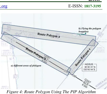
[image:4.612.312.533.66.260.2]Figure 4 illustrates the problem of PIP used to monitor the aircraft navigation route of the current air traffic control system. The route illustrated in figure 4 is between Korea and Japan.
Figure 4: Route Polygon Using The PIP Algorithm
To calculate RAM by means of the air traffic control system, a polygon needs to be formed to connect the fixed points in a designated route. Since each route is not a right-angled tetragon, the corrected inclination value of the longitude and latitude needs to be reflected in the formation of polygons for accuracy.
Otherwise, a route polygon may be deformed as shown in a). b) shows when an aircraft‘s route corresponds to the border of a route polygon. According to the regulations of RAM, this may be viewed as appropriate because it remains exactly in the designated area, but when PIP algorithm, which adopts the odd/even number rules of polygon lines that an aircraft passes over, is used, it is difficult to determine whether the aircraft remains actually in the polygon area.
3.2 Proposed Methods
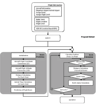
Figure 5 is a logical block diagram of a system for predicting aircraft flight paths and generating RAM using the proposed method.
3.2.1 Distance Calculation Method
Figure 6 shows a flow chart of the relative distance calculation procedures based on the position values as proposed in this paper.
The objects of distance calculation as required in the air traffic control system are as follows:
1351
Figure 6: Distance Calculation By Means of Vincenty Formula Algorithm
Distance between an aircraft and a fixed point: When an aircraft passes through a route transformation route, this value is used for proper determination of the turning radius. The relative distance between an aircraft and a fixed point is measured.
Distance between fixed points: This value is used to calculate the total distance of an aircraft flight route and the arrival time at each fixed point. The relative distances between all the fixed points that the aircraft passes through in the allocated route are measured and summed up.
The specific procedures and methods regarding figure 6 are the same with those of Step. 1, Step. 2, and Step. 5 in section 3.2.2.
1352
3.2.2 Route Adherence Monitoring Method
In this paper, rectangular coordinates for lines and points are used to map virtual aircraft positions in a route, and the distance between a simulated aircraft and an actual aircraft is calculated and applied to RAM. Figure 7 shows the procedures of the proposed method.
Step 1. The actual positon of the aircraft recognized by radar and the allocated route defined in the flight plan are entered. The allocated route is converted into connection of fixed points as follows:
Departure / Arrival Airport: RKSS (Gimpo Airport in Incheon FIR (Flight Information Region) ) / RKPC (Jeju Airport in Incheon FIR)
Assigned Route: OSN B576 IPDAS DCT CJU
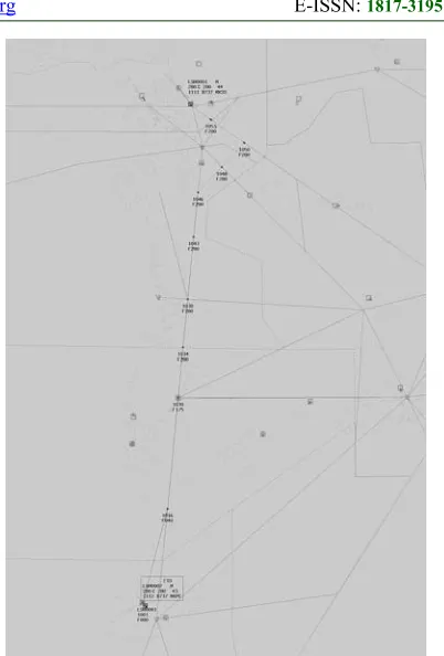
[image:6.612.320.521.76.373.2] Converted Route figure 8: RKSS-OSN- NUMDA-DADGA-ALADI-KWA-IPDAS-CJU-RKPC
Figure 7: Procedures For RAM Calculation
Figure 8: Aircraft Route Prediction
Step 2. For the converted route, WGS-84 coordinate is allotted to each fixed point. The allotted WGS-84 coordinate is converted into a real number for calculation.
Coordinate assign: IPDAS -> N341515/ E1264301
Step 3. A virtual straight line that connects the first and second fixed points is set, and the inclination of the line is calculated. It is determined if the position coordinate of the virtual aircraft corresponds to the designated segment.
Input aircraft coordinate: N341113/E1262104
[image:6.612.93.301.194.604.2]1353
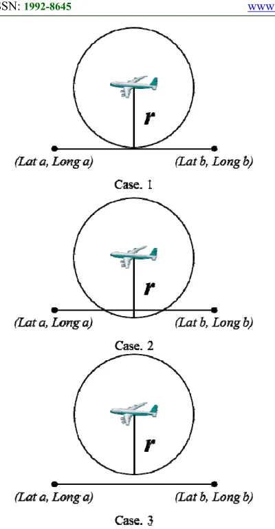
Figure 9: An Example Of An Intersection Of A Circle And A Straight Line
Step 4. A circle for RAM settings based on the aircraft position coordinate (r, e.g.; 10 NM) is formed, and then the intersection of the straight line and circle is calculated. Figure 9 shows an example of generating an intersection for a straight line and a circle.
Case. 1: If there is one intersection of a circle and a straight line, it means that the aircraft is flying over the border set by RAM.
Case. 2: If there are two intersections of a circle and a straight line, it means that the aircraft is flying within the area of RAM settings.
Case. 3: If there is no intersection, it means that the aircraft is flying out of RAM settings. This initiates RAM alert.
If there is no intersection of a circle and a straight line in connection with rectangular coordinates, Step. 2 and Step. 4 should be repeated to calculate all fixed points in the assigned route.
Step 5. The distance between the virtual aircraft coordinate in the route calculated in Step. 3 and the actual aircraft position coordinate are calculated by means of Vincenty formula algorithm.
4. IMPLEMENTATION AND ANALYSIS OF THE PROPOSED METHOD
4.1 Accuracy of Distance Calculation
Figure 10 shows the error measurements in time and distance when Great-Circle algorithm and Vincenty formula algorithm were used for distance calculation. The inputs are 9 fixed points from “RKSS (Gimpo airport in Incheon FIR)” all the way up to “KWA (Kwangju airport in Incheon FIR).” The measuring process was repeated 100,000 times to get the results presented in figure 10.
The experiment result indicates that when Vincenty formula algorithm was used, it took about 2.47 times more than when great-circle algorithm was used when it comes to the calculation time probably because the former used more complicated calculation expressions than the basic numerical expressions. As for the accuracy of distance calculation, the calculation by means of Vincenty formula algorithm (275.8 km) was 0.0029% more accurate than that of great-circle algorithm (276.6 km) probably because the accuracy was enhanced as much as about 1 km per 300 km.
1354 a) Processing Time
[image:8.612.89.524.61.442.2]b) Distance Calculation Result
Figure 10: Comparison Between Great-Circle And Vincenty Formula
4.2 RAM and Route Prediction
Figure 11 shows an example of applying the proposed method to an air traffic control system. It was applied to such functions as 4D trajectory modeling, flight alert, and conformance monitoring of FDP (Flight Data Processor) as part of ATC.
[image:8.612.249.513.65.377.2]Figure 12 shows an example of applying the proposed method to RAM. Case. 1 is an alert to RAM settings of 15 NM, and Case. 2 an alert to RAM settings of 10 NM. Both Case. 1 and Case. 2 generated accurate alert when the aircraft got out of the set RAM values.
Figure 11: An Example Of Applying The Proposed Method To A FDP
Case. 1
Case. 2
[image:8.612.90.306.73.432.2] [image:8.612.336.499.407.695.2]1355
4.3 Meaning of this paper
CNS/ATM, and PBN are technologies for ensuring the operation of more aircraft in restricted airspace. In order to ensure the operation of more flight in restricted airspace, the following requirements shall be met.
Gathering exact location information of the aircraft ;
Gather information on real-time aircraft movements (routes, altitude, speed, etc.)
Prediction of Long-Range Aircraft Flow in the Air-Space
Large capacity air traffic control information processing technology
Application of highly precise calculation algorithms
Minimize separation of aircraft
In this paper, I applied the following method to meet these requirements.
Using GPS-based accurate aircraft location information
Improved accuracy of distance measurement using the Vincenty formula algorithm
The improved measurement accuracy of aircraft-to-aircraft, aircraft-to-route compliance using Cartesian coordinate system algorithms
Improve the accuracy of 4-D route modeling.
As shown in Figure 10.a, the algorithms applied in this paper were not applicable to existing ATC systems because they require more execution time compared to existing algorithms. However, the next-generation ATC systems, developed with the recent developments in ICT (Information and Communication Technology) technology, including software/hardware, and the lower cost of high-performance systems, will be able to take advantage of the methods proposed in this paper.
5. CONSIDERATION
BlackHat has announced how to hack the traffic control system in 2014. External hackers performed a DoS (Denial of Service) attack targeting the traffic control system. As a result of the hacking attack, the traffic control system was interrupted and traffic management on the public roads became paralyzed [20]. It also demonstrated that it is possible to abduct the aircraft by disturbing the location information of the aircraft [21]. It has been confirmed that the existing air traffic control system is not safe from external hacking threats due to the above hacking method.
Therefore, in this paper, we propose a method to protect air traffic control system by external hacking threat. Figure 13 is a unidirectional security gateway configuration for secure transmission of aircraft safety information. The aircraft safety information is transmitted to the controller or external system via a unidirectional gateway. However, data transmission from the external system is not transmitted to the aircraft
safety alert system because the reverse packet is blocked.
6. CONCLUSION
In this paper, I proposed a scheme to support minimize the separation of aircraft using ADS-B fused track data sensor data fusion and to allow more aircraft in restricted airspace. This way can be applied to existing air traffic control systems. The proposed method was actually applied to an FDP, which was part of an air traffic control system, and as a result, the accuracy of distance measurement was improved as much as 0.003%. It was possible to accurately determine if the aircraft could navigate in the allocated route without applying corrected values in the formation of a polygon for each route.
[image:9.612.99.514.368.443.2]Security of aircraft safety information is very important to ensure safe aircraft operation. Therefore, it is necessary to research the method to transmit the safety information of aircraft generated in this paper to the air traffic control system using unidirectional data transmission. Future research in this paper is to proposed method for transmitting aircraft safety information through a physical
1356 unidirectional security gateway (UNIWAY – UNIdirectional security gate WAY).
ACKNOWLEDGEMENTS
This work was supported by the ICT R&D program of Ministry of Science, ICT and Future Planning/Institute for Information & communica-tions Technology Promotion (MSIP/ IITP) [R0126-15-1095, Unidirectional Security Gateways developments in cyber-physical systems].
REFRENCES
[1] GALOTTI, Vincent P. The Future Air Navigation System (FANS). 1997.
[2] VISMARI, Lucio Flavio; JUNIOR, João Batista Camargo. A safety assessment methodology applied to CNS/ATM-based air traffic control system. Reliability Engineering & System Safety, 2011, 96.7: 727-738.
[3] MOHLEJI, Satish C.; LACHER, Andrew R.; OSTWALD, Paul A. CNS/ATM System Architecture Concepts and Future Vision of NAS Operations in 2020 Timeframe. In: AIAA's 3 rdAnnual Aviation Technology, Integration, and Operations (ATIO) Technical Forum, Denver, CO. 2003.
[4] ICAO, DOC. 9613, Performance-Based Navigation (PBN) Manual. The Internaltional Civil Aviation Organization, Third edition, Montreal, Canada, 2008.
[5] MULLER, Delri; UDAY, Payuna; MARAIS, Karen B. Evaluation of the potential environmental benefits of RNAV/RNP arrival procedures. In: 11th AIAA ATIO conference Virginia. dx. doi. org/10.2514/6.2011-6932. 2011.
[6] HARALDSDOTTIR, Aslaug, et al. Arrival management with required navigation performance and 3D paths. In: 7th USA/Europe Air Traffic Management R&D Seminar, Barcelona, Spain. 2007.
[7] MOHLEJI, Satish C.; LACHER, Andrew R.; OSTWALD, Paul A. CNS/ATM System Architecture Concepts and Future Vision of NAS Operations in 2020 Timeframe. In: AIAA's 3 rdAnnual Aviation Technology, Integration, and Operations (ATIO) Technical Forum, Denver, CO. 2003.
[8] LEE, Seoung-Hyeon; KIM, Yong-Kyun; LEE, Deok-Gyu. Conformance monitoring method based 4D trajectory modeling using aircraft performance data. JoC, 2014, 5.2: 28-36.
[9] MAYER, Ralf H., et al. Toward a performance-based NAS: Airports for potential application of PBN-enabled departure separation standards. In: Integrated Communications, Navigation and Surveillance Conference (ICNS), 2013. IEEE, 2013. p. 1-16.
[10] DROUILHET JR, Paul R.; KNITTEL, George H.; ORLANDO, Vincent A. Automatic dependent surveillance air navigation system. U.S. Patent No 5,570,095, 1996.
[11] STROHMEIER, Martin, et al. Realities and challenges of nextgen air traffic management: the case of ADS-B. IEEE Communications Magazine, 2014, 52.5: 111-118.
[12] LEE, Seoung-Hyeon, et al. Protection method for data communication between ADS-B sensor and next-generation air traffic control systems. Information, 2014, 5.4: 622-633. [13] WEISSTEIN, Eric W. Great circle. 2002. [14] NASTRO, Vincenzo; TANCREDI, Urbano.
Great circle navigation with vectorial methods. The Journal of navigation, 2010, 63.3: 557-563.
[15] VINCENTY, Thaddeus. Direct and inverse solutions of geodesics on the ellipsoid with application of nested equations. Survey review, 1975, 23.176: 88-93.
[16] THOMAS, C. M.; FEATHERSTONE, W. E. Validation of Vincenty’s formulas for the geodesic using a new fourth-order extension of Kivioja’s formula. Journal of Surveying engineering, 2005, 131.1: 20-26.
[17] HORMANN, Kai; AGATHOS, Alexander. The point in polygon problem for arbitrary polygons. Computational Geometry, 2001, 20.3: 131-144.
[18] KIFANA, Benny Dwi; ABDUROHMAN, Maman. Great Circle Distance Methode for Improving Operational Control System Based on GPS Tracking System. International Journal on Computer Science and Engineering, 2012, 4.4: 647.
[19] Accuracy settings, https://www.jimcarson.com/macfizzycalc/accur acy.html
[20] GHENA, Branden, et al. Green Lights Forever: Analyzing the Security of Traffic Infrastructure. WOOT, 2014, 14: 7-7.
[21] COSTIN, Andrei; FRANCILLON, Aurélien. Ghost in the Air (Traffic): On insecurity of B protocol and practical attacks on ADS-B devices. ADS-Black Hat USA, 2012, 1-12.