A Geodesign Approach for Using Spatial Indicators
in Land-use Planning
Andrea Matta
1,*, Matteo Serra
21Department of Civil and Environmental Engineer, University of Cagliari, Italy 2Department of Architecture, University of Cagliari, Italy
Copyright©2016 by authors, all rights reserved. Authors agree that this article remains permanently open access under the terms of the Creative Commons Attribution License 4.0 International License
Abstract
This paper presents an original approach to Strategic Environmental Assessment (SEA) for supporting decision-making processes in Local Land-Use Planning (LLUP) which integrates a set of frameworks and methodologies into technologies based on the use of Geographic Information. The technologies embrace the domain of Planning Support Systems (PSS), whose architecture is based on the Geodesign framework. The structure of the Planning Support System includes spatial indicators frameworks rooted on the Driving Force-Pressure-State-Impact-Response (DPSIR) framework. The spatial DPSIR model allows dealing with common issues in spatial planning, such as collaborative and participative decision-making processes, informed alternative design, real-time impact assessment and environmental reporting. Furthermore, the planning support system may foster the widespread diffusion of innovations in the planning domain reeling on the availability of Spatial Data Infrastructures. The study aims at investigating the efficiency of this approach integrated into SEA-LLUP based on the results of a case study developed in Sardinia (Italy).Keywords
Planning Support System, Geodesign, DPSIR, Spatial Indicators, Land-use, Strategic Environmental Assessment1. Introduction
The sprawl of the cities and the urbanization processes have gobbled up a big amount of rural and natural areas, jeopardising the quality of environmental resources [1, 2]. Indeed, the evaluation process of the consumption of resources is a current challenge for environmental scientists and planners, who have to deal with the loss of natural capital and the general preservation of well-being for the future generations [3]. Urban development is usually related to the conversion of natural areas, whose ownership may be public or private. Often, the set of policies that regulate land-use
and influences the rights of private landowners is oriented towards preserving natural areas and limiting the urbanization processes. By contrast, often landowners aim to achieve their advantage through specific actions, consuming local resources. The sum of these actions produces a range of cumulative effects on the environment that have to be considered in the decision-making stages, through specific plans, rules and policies. These phenomena led to producing several threats for the environment, from the local to the global scale, such as erosion and desertification, loss of biodiversity, climate changes and flooding [4].
The concept of sustainability concerns the "development that meets the needs of the present without compromising the ability of future generations to meet their own needs" [5]. Indeed, sustainable development aims to ensure an adequate degree of quality of the resources, their accessibility and their availability for the future generations.
This general statement needs to be translated into policies and plans for supporting concrete applications. Jepson [6] pointed out that sustainability and planning are inextricably linked, in order to create a system to "protect the natural environment, meantime the economy has to be developed and the equity achieved".
In the last decades, the European Union has proposed a range of policies with the aim of integrating environmental considerations into projects, plans and programmes for protecting the environment. The Environmental Impact Assessment (EIA, Directive 85/337/EEC) and the SEA (Directive 2001/42/EC) directives are two of such policies that put into effect the European Union’ objectives regarding the environmental preservation.
concluded within one year of approval of the RLP for all the municipalities, only a few MMPs have been revised until recently [35] and a range of difficulties are still presented [21].
In the light of the above premises, the paper is organized as follows. The first part introduces current pitfalls and weaknesses in spatial planning, focusing on the integration of the European Directives and innovations in planning practices. The second section illustrates a possible way of dealing with these issues, through innovative methodologies and technological innovations. The third part demonstrates how to operatively integrate this innovative approach to planning for filling the gap between research and practice, through a case study based on SEA-LLUP procedures in Sardinia (Italy). Finally, the conclusions highlight the results of the workshop and possible further research.
2. Current Barriers for Integrating
Innovations in Spatial Planning
The intrinsic complexity of Land-Use Planning concerns a range of activities for managing the use of land in compliance with future planning objectives. The current innovation in computer-aided planning and accessibility to (geographic) data is fostering breakthroughs in decision-making [8]. Recently, the integration of European policies into the Italian National legal framework has promoted an environmental strategic approach to spatial planning. Despite these environment-oriented developments and the growth of the Information and Communication Technology (ICT) domain, a fruitful implementation in planning practices seems to be far from complete.
2.1. The INSPIRE Directive
The integration of the INSPIRE Directive (2007/2/EC) into the legal framework of European member states, promotes the creation and use of Spatial Data Infrastructures (SDIs) to assist in formulating and integrating Community environmental policies across Europe. The concept of SDI arose in 1993 by the U.S. National Research Council, in order to guarantee the accessibility to Geographic Information (GI) for potential
with the aim of sharing data and services to all web users, via download or network services. The SRSDI offers more than 300 spatial data and services which can be used for supporting Local Land-Use Planning activities.
Despite the importance of SDIs is evident at the Regional at the Local level, their efficiency in strategic planning and decision-making is still limited [11]. Indeed, the breakthroughs in the integration of SDIs into spatial planning processes, contrast with a range of pitfalls, such as incompatible and inconsistent spatial databases and limited accessibility to GI [36].
2.2. An Environment-oriented Planning Approach
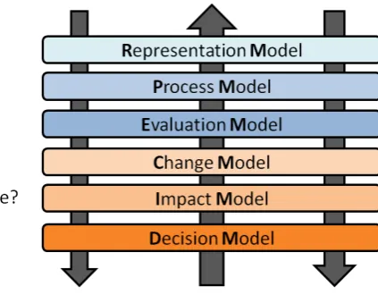
Figure 1. The Geodesign Models (Source: Author)
3. Innovations and Methodologies for
Supporting LLUP
3.1. The Geodesign Methodology
Geodesign is an emerging methodological approach to planning and design that encompasses representation, analysis, design and impact assessment of the geographical space, through the participation of different stakeholders and professionals to decision-making. The Geodesign framework (GDF) may be able to bring innovation in spatial planning across different spatial scales [22], and address the current issues in the SEA procedures [10]. The GDF consists in six interactive models that operate for offering an innovative structure for dealing with planning processes (Fig. 1). The Representation Model (RM) describes the environmental system in an attempt to bring a fruitful comprehension of the geographic space on which the Geodesign team operates. In turn, the Process Model (PM) and the Evaluation Model (EM), generate information to investigate the dynamics of environmental phenomena and manage territorial weaknesses and strengths for addressing development strategies. The Change Model (CM), takes into account the knowledge base generated through the first three models to design scenarios, including solutions and alternatives. Finally, the influence of the design activities on the environment is evaluated through the Impact Model (IM) with the aim of producing information and supporting suitable decision processes (Decision Model – DM). The implementation of the GDF may occur in different ways which can be supported by Planning Support Systems. An early attempt to demonstrate the efficiency of Geodesign-based PSS architecture for supporting LLUP was carried out by Campagna and Matta [10]. An early approach to structured information flow integrated into LLUP procedures was carried out through a spatial indicators framework, claiming the need for further research.
3.2. The Planning Support System Architecture
The term Planning Support System (PSS) is not new. It
urban parameters change during the design activities. In addition, they support the monitoring program for evaluating the influence of the design activities on the environment. According to the requirements of the regional planning regulations and the SEA-LLUP guidelines in Sardinia, a set of structured indicators have to be implemented in the Environmental Report (ER) for integrating impact assessment and monitoring program.
The most important indicators frameworks used at the international and the national level are based on the concept of causal chains, where the output of each component of the
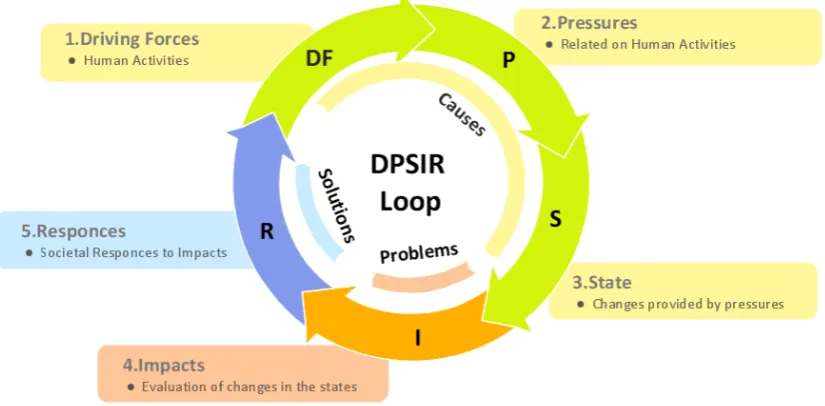
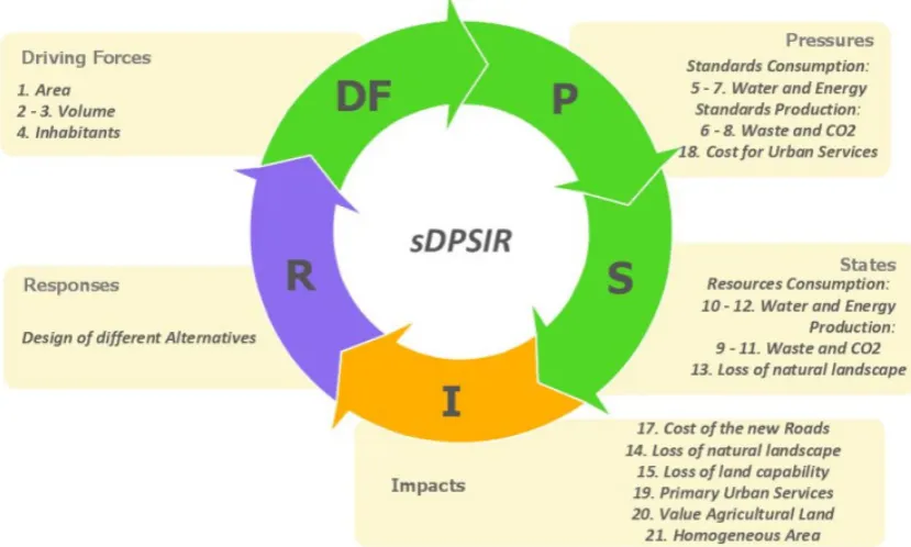
[image:4.595.101.514.384.587.2]five components that support the comprehension of phenomena and fills the gap between the real world and its representation. These components interact in a loop (Fig. 2): (i) Drivers (D), (ii) Pressures (P), (iii) States (S), (iv) Impacts (I) and (v) Responses (R). The first three components represent the “causes” that generate the “problems”, encompassed in the fourth component. In turn, the fifth component deals with the problem putting the basis for the “solution(s)” [32].
Figure 2. The DPSIR framework (Source: Author)
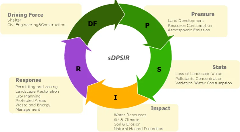
The Environmental Protection Agency (EPA), provides generic relationships among the DPSIR components for supporting the integration of the framework into spatial planning. These relationships drove the connections between the DPSIR framework with the GDF, as argued by Campagna and Matta [10] (Fig. 3). The iterations of the DPSIR loop are intertwined with the GDF models: the first loop concerns the analysis of the current territorial conditions (RM, PM and EM), such as the representation and analyses of current urban-environment phenomena and general proposals for producing future development strategies of the territory. The information and spatial data produced in this early phase can be considered the base on which operatively modelling the geographic space in compliance with the planning objectives and the sustainable resource consumption (CM, IM and DM) (Fig. 3).
Figure 3. The relationships between DPSIR framework and GDF
The fig. 3 shows an early integration of the sDPSIR framework into SEA-LLUP, implemented in 2014 [10]. In order to extend the investigation into the role of spatial indicators in LLUP practices, a case study that concerns a practical workshop in the municipality of Gonnesa (Sardinia, ITALY) is proposed in the next paragraphs.
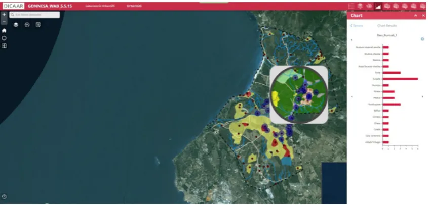
[image:5.595.97.515.496.726.2]Figure 5. The Web-based PSS architecture for representing and analysing the DPS components
4. A SEA-LLUP Workshop for
Integrating Innovations in Practices
4.1. The sDPSIR Integrated into a Geodesign-based PSS Architecture
The case study concerns a workshop on LLUP, realized by the UrbanGIS Lab of the University of Cagliari, in collaboration with the local authority of the municipality of Gonnesa. It was carried out in compliance with the COST TU 1002 guidelines for innovating spatial planning practices [37]. The group of participants to the workshop (Workshop Users - WUs) was composed by a range of professionals, researchers, and local administrators, with the aim of making value of their experiences for comparing current practices and the proposed methodologies and innovations.
The workshop aims to investigate how technological innovations and emerging methodologies may influence current planning practices. The goal was to analyse the process of location, design and evaluation of a new touristic area in the municipality area. This paper takes into account the influence of these innovations in spatial planning for demonstrating the role of GI and spatial indicators for supporting collaborative decision-making.
4.1.1. Representation and Process Models
The first phase of the workshop was oriented both to represent the municipal territory and to perform spatial analyses through the use of spatial data, made available by the Regional SDI (SRSDI) and the public administration. In a broad sense, the WUs were able to compare the current system for sharing and represent spatial and non-spatial data of the local administration with the innovative approach based on a Web-architecture. In this phase, a Web-Based PSS was used to generate information and integrate the Representation Model and the Process Model into practice (Fig. 5). The Web-based PSS is an architecture that makes available a range of thematic maps, such as the current
land-uses, hydrogeological hazards and cultural and historical goods, and a range of nested geo-tools for performing spatial analyses (e.g. the number of historical sites in a specific portion of the area). The outputs of these analyses are shown through spatial indicators, representing the first three component of the sDPSIR: DF, P and S. Indeed, the values of the indicators represent the Driving Forces that dominate the urban phenomena (i.e. number of inhabitants, residential volumes and areas) and produce Pressures on the environment (i.e. soil consumption, costs). In turn, the PM, through the geo-tools, provides the information for feeding the State component (i.e. loss of natural landscape, production of goods and services). 4.1.2. Evaluation Model
The third phase of the workshop is based on the management and the analyses of the knowledge generated through the RM and PM. Indeed, the first three components of the sDPSIR depict the “causes” of the “problem” that in turn, generate the Impacts on the environment. This information flow allows establishing both the environmental questions and the development goals for the territory. These issues can be dealt with a range of proposals that may arise from different groups of stakeholders, related to their own purposes, such as environmental and socio-economic questions. Nevertheless, if not adequately supported by methodologies and analysis tools, the process of combination and analyses of different planning goals may be too complex. For this reason, the EM supports the process of evaluation of these purposes, driving the design of future suitable alternatives.
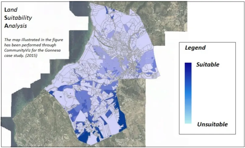
Figure 6. An Evaluation map for supporting the development of future strategies The LSA tool allows combining a wide range of spatial
data for producing maps that represent the result of a range of spatial analyses. The maps, namely suitability maps, concern specific urban and environmental phenomena that should be analyzed for defining the alternatives in the CM. The spatial data are combined through different spatial operations, such as weighted selections, that generate a range of criteria, which value can be changed during the negotiation phase. These variations produce real-time changes in the suitability maps, offering different planning solutions. The maps may represent, with a different colour ramp, for instance, the suitability rate of adequate sites for the planning purposes. The lightest colours represent the lowest suitability rate, where the combination of selected criteria defines the non-adequate areas. The darkest colours concern the highest suitability rate, representing the adequate areas for the proposed planning goal (Fig. 6).
The WUs were able to produce real-time map variations, thanks to a set of dynamic weighted attributes (e.i. proximity to the main roads), informing the discussion regard their own purposes for future territorial developments (Fig. 6).
The evaluation maps represent the location of suitability areas on the territory for a specific planning goal, in order to deal with the “causes of the problems”, depicted through the Impact component of the DPSIR framework. The group of spatial indicators related to the Impact, show the influence of the design activities on the environment, through a dynamic dashboard enclosed in the PSS architecture. It can be argued that the impact component embraces the base-knowledge of the territory both for supporting planners in design activities and for driving suitable planning solutions, in compliance with participative and collaborative planning procedures.
4.1.3. Change and Impact Model
The CM encloses the transformation of the geographical space due to the results by the design setting. The causes of the territorial metamorphosis may have different drivers, represented through the DPSI components. In order to support planners for dealing with this task, the CM is supported by the PSS architecture through the sketch planning tool that makes the users able to design a range of alternatives. The sketch planning is a GIS-based planning tool that allows putting into effect abstract concepts for evaluating their effect on the environment referring to a specific planning objective [34]. The WUs were able to negotiate a range of alternatives based on the evaluation maps, for generating different scenarios. Each design solution is related to a real-time variation of the spatial indicators that foster the comprehension of the design influence on different domains (e.g. environmental, social and economic).
Figure 7. How the sDPSIR is able to help planners to manage information during the plan-making phases
The CM and the IM operate at the same time, representing how changes in the geographical space are instantly related to a variation of different parameters. The DPSIR framework nested in the PSS architecture is able to support the communication of information to stakeholders in a simple way, improving the comprehension of how these alternatives influence the environment and providing a structure for organising complex information flow along the decision-making procedures.
4.1.4. Decision Model
The different scenarios and the relative environmental impacts show how the decision-making process may influence the environment and the citizen’ well-being. In order to generate a suitable response to the planning goal, the scenarios should be compared and analyzed. The process of comparison may lead to operating further design activities for enhancing the final design solution. This process contributed to the production of the final alternatives is in compliance with both the planning goal and the stakeholder’ purposes. The “responses” generate a negotiation among stakeholders with the aim of merging the requests of sustainable resource consumption from the SEA and the purposes of economic and urban growth from the local administration. The final scenario represents both how the information flow supports the decision-making process since the early phases, starting from the analysis of the current situation to the scenarios comparison, and how the sDPSIR contributes to the management of this information (Fig. 7). The DM depicts the future developments of the municipal territory in an attempt to communicate in a simple way the intrinsic complexity on which the decision-making process is based.
5. Conclusions
Land-Use planning encompasses a wide range of methodologies, technologies and groups of people, such as politicians, citizens and stakeholders, in order to orchestrate the uses of lands in compliance with sustainable development goals [38]
In this context, the paper presents an innovative approach to Strategic Environmental Assessment of a Local Land-Use Planning Support System implemented for the municipality of Gonnesa (Sardinia, Italy). The case study shows how structured GI frameworks, integrated into SEA-LLUP procedures, fulfil an important role in supporting decision-making processes.
The PSS architecture allow the integration of the GI in the Sardinian planning context, and may contribute to dealing with the complexity of planning activities in all the plan-making phases, such as the creation of the base-knowledge for generating an informed design of alternatives and for supporting the negotiation among stakeholders.
role of the GI technologies across the plan-making phases in the Sardinia planning context.
The workshop was enriched by a range of questionnaires for assessing the WUs’ opinions on this innovative approach to SEA-LLUP. The participants pointed out that the PSS architecture, and in particular the management of the information flow across the decision-making, may be considered a reliable plan-making support. Moreover, the PSS architecture allows not only of dealing with the request of the SEA-LLUP procedures both for integrating informed environment-oriented procedures into practice and monitoring their impact, but also of fostering a transparent and collaborative decision-making process, from the early plan-making phases until the final decision, supporting a shared comprehension of the planning processes among stakeholders and decision-makers.
In conclusion, this PSS can be considered an innovative approach that contributes to the integration of the Geodesign framework into planning activities, such as in the representation and analysis of the current territorial context, in the design of plan alternatives, in the support of the participation processes and in the evaluation of the most suitable development scenario. The sDPSIR framework may contribute to putting into effect the GDF models in practice, supporting the planning process through an informed design of alternatives and a real-time impact evaluation across the decision-making phases.
However, the results illustrated in the paper concern an early approach to planning practices, for this reason, further case studies may contribute to ameliorating the architecture for dealing with the complexity of the plan-making activities.
Acknowledgements
The work presented in this paper was developed in the framework of the International PhD in Environmental Science and Engineering at the University of Cagliari. We would like to thank Matteo Serra for his efforts on organizing the workshop and the Web-based PSS architecture.
REFERENCES
[1] Wang, H., Shen, Q., and Tang, B. S. (2014, January). A Review of Planning Support Systems for Urban Land Use Planning. In Proceedings of the 17th International Symposium on Advancement of Construction Management and Real Estate (pp. 233-248). Springer Berlin Heidelberg. [2] Kötter, T., and Friesecke, F. (2005, October). Urbanization
and Megacities–The Challenge of the 21st Century. In The 6th Open Meeting of the Human Dimensions of Global Environmental Change Research Community, University of Bonn, Germany (pp. 9-13).
[3] Olewiler, N. (2006). Environmental sustainability for urban
areas: The role of natural capital indicators. Cities, 23(3), 184-195.
[4] Caparros-Midwood, D., Barr, S., and Dawson, R. (2015). Optimized spatial planning to meet long term urban sustainability objectives. Computers, Environment and Urban Systems, 54, 154-164.
[5] Brundtland, G., Khalid, M., Agnelli, S., Al-Athel, S., Chidzero, B., Fadika, L., ... and Okita, S. (1987). Our Common Future (\'Brundtland report\').
[6] Jepson, E. J. (2001). Sustainability and planning: diverse concepts and close associations. Journal of planning literature, 15(4), 499-510.
[7] Zoppi, C., Lai, S., (2008), “Strategic Environmental Assessment of a Landscape Plan: A Case Study Concerning Sardinia, an Italian Region” in: European Regional Science Association, 48th Congress, Liverpool, Regno Unito, presented in the Session 10.Y: Sustainability and environmental management.
[8] Couclelis, H. (2005). "Where has the future gone?" Rethinking the role of integrated land-use models in spatial planning. Environment and planning A, 37(8), 1353.
[9] Citroen, C. L. (2011). The role of information in strategic decision-making. International Journal of Information Management, 31(6), 493-501.
[10]Campagna, M., and Matta, A., (2014, August). Geoinformation technologies in sustainable spatial planning: a Geodesign approach to local land-use planning. In Second International Conference on Remote Sensing and Geoinformation of the Environment (RSCy2014) (pp. 92290T-92290T). International Society for Optics and Photonics.
[11]Craglia, M., and Campagna, M. (2009). Advanced regional spatial data infrastructures in Europe. Luxembourg: Office for official publications of the European Communities. [12]Abaza, H., Bisset, R., and Sadler, B. (2004). Environmental
impact assessment and strategic environmental assessment: towards an integrated approach. UNEP/Earthprint.
[13]Fischer, T. B. (2010). The theory and practice of strategic environmental assessment: towards a more systematic approach. Routledge.
[14]Geneletti, D., Bagli, S., Napolitano, P., and Pistocchi, A. (2007). Spatial decision support for strategic environmental assessment of land use plans. A case study in southern Italy. Environmental Impact Assessment Review, 27(5), 408-423. [15]Tetlow, F., M., and Hanusch, M., (2012). Strategic
environmental assessment: the state of the art. Impact Assessment and Project Appraisal, 30(1), 15-24.
[16]Weiland, U., (2010), "Strategic environmental assessment in Germany—practice and open questions." Environmental Impact Assessment Review 30.3 211-217.
[17]Therivel, R., Christian, G., Craig, C., Grinham, R., Mackins, D., Smith, J., and Yamane, M. (2009). Sustainability-focused impact assessment: English experiences. Impact Assessment and Project Appraisal, 27(2), 155-168.
City (pp. 307-327). Springer International Publishing. [22]Steinitz, C. (2012), A Framework for Geodesign. Changing
Geography by Design, Esri Press, and Redlands.
[23]Harris, B. (1989). Beyond geographic information systems. Journal of the American Planning Association, 55(1), 85-90. [24]Klosterman, R. E. (1997). Planning support systems: a new
perspective on computer-aided planning. Journal of Planning education and research, 17(1), 45-54.
[25]Geertman, S., and Stillwell, J. (2004). Planning support systems: an inventory of current practice. Computers, Environment and Urban Systems, 28(4), 291-310.
[26]Malczewski, J. (2004). GIS-based land-use suitability analysis: a critical overview. Progress in planning, 62(1), 3-65. [27]Heppenstall, A. J., Crooks, A. T., See, L. M., and Batty, M.
(Eds.). (2011). Agent-based models of geographical systems. Springer Science and Business Media.
[28]Hammond, A., and World Resources Institute. (1995). Environmental indicators: a systematic approach to measuring and reporting on environmental policy performance in the context of sustainable development (No. 333.7/H225). Washington, DC: World Resources Institute. [29]Smeets, E., and Weterings, R. (1999). Environmental
“Policies and tools for sustainable water management in the EU. Venice, Italy.
[33]Apitz, S. E. (2007). Conceptual frameworks to balance ecosystem and security goals. In Managing Critical Infrastructure Risks (pp. 147-173). Springer Netherlands. [34]Harris, B. (2001). Sketch planning: Systematic methods in
planning and its support. Planning Support Systems: Integrating Geographic Information Systems, Models, and Visualization Tools, 59-80.
[35]De Montis, A., Ledda, A., Caschili, S., Ganciu, A., and Barra, M. (2014). SEA effectiveness for landscape and master planning: An investigation in Sardinia. Environmental Impact Assessment Review, 47, 1-13.
[36]Craglia, M., and Annoni, A. (2007). INSPIRE: An innovative approach to the development of spatial data infrastructures in Europe. Research and Theory in Advancing Spatial Data Infrastructure Concepts, 93-105.
[37]te Brömmelstroet, M., Silva, C., and Bertolini, L. (Eds.). (2014). Assessing usability of accessibility instruments. COST office.