Flooding is an important concern for many waterways in Humboldt County, including the Eel River (including the Van Duzen and South Fork), the Mad River, Eureka Plain (especially Freshwater and Jacoby Creeks), and the Trinity River. Tsunamis are addressed in Chapter 10, Geologic and Seismic Hazards.
The first two sections of this chapter describe historical floods and methods of describing flood risk. Then, flood protection measures and the regulatory framework for flood hazard management are summarized. The final section addresses existing General Plan policies and policy issues identified during Phase I, as summarized in the Critical Choices Report, along with policy options that respond to them. The Appendices include the policy evaluation worksheets.
11.1 HISTORICAL FLOODS
Seventy percent of precipitation in Humboldt County occurs from November to March and major floods have resulted from a succession of intense rainstorms during these months. The two worst floods in Humboldt County history occurred in December 1955 and December 1964, causing tens of millions of dollars in damages and numerous fatalities. EPA notes that the storms of January 1997 caused Humboldt County’s fifth-largest flood on record, but apart
from landslides and road failures, the damage done is not of the same magnitude.1
The 1955 flood occurred following weeks of above-normal precipitation in the county, with rainfall measurements reaching as high as 24 inches over three days in Cummings. Damages in the Eel River Basin exceeded $22 million, with one reported fatality and 43,000 acres
flooded.2 Heavy debris carried by high velocity river flows is faulted for much of the damage.
Heavy rains accompanied by runoff from an unusually large snowpack led to the flooding of the Mad and Eel Rivers in 1964. Total damages reached $100 million, with entire communities (including Pepperwood, the site of the 1955 fatality) being destroyed and 19 fatalities recorded. Millions of board feet of lumber, thousands of acres of prime farmland,
and 4,000 head of livestock were also lost.3
1
Redwood Creek Total Maximum Daily Load Comment Responsiveness Summary, December 29, 1998. 2
Humboldt County General Plan Policy Background Study: Hazards, May 1982, p 2-12. 3
11.2 FLOOD MEASUREMENT
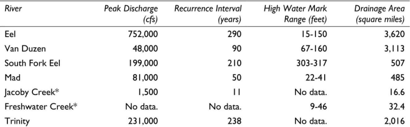
Floods are commonly described as having a 10-, 50-, 100-, and 500-year recurrence interval, meaning that floods of these magnitudes have (respectively) a 10, 2, 1, or 0.2 percent chance of occurring in any given year. These measurements reflect averages of likelihood of occurrence; it is possible that two or more rare floods (with a 100-year or higher recurrence interval) could occur within a short time period. Assigning recurrence intervals to the discharges of historic floods is valuable both as a rough comparison among the magnitudes of different flood intervals on a given waterway, as well as a way of showing the intensity of a storm over a large area. The recurrence intervals shown for various waterways in Humboldt County in December 1964 (see Table 11-1) point to the relative effects the storm had on different watersheds; flooding along the Eel River was much more severe than along Jacoby Creek, even when factoring in their size difference.
Table 11-1: December 1964 Flood Statistics
River Peak Discharge (cfs)
Recurrence Interval (years)
High Water Mark Range (feet)
Drainage Area (square miles)
Eel 752,000 290 15-150 3,620
Van Duzen 48,000 90 67-160 3,113
South Fork Eel 199,000 210 303-317 507
Mad 81,000 50 22-41 485
Jacoby Creek* 1,500 11 No data. 16.6 Freshwater Creek* No data. No data. 9-46 32.4
Trinity 231,000 238 No data. 2,016
*Jacoby Creek and Freshwater Creek are similar; Jacoby Creek data are used for discharge and recurrence; Freshwater Creek data for HWM. Note that the 1964 flood was the third-largest recorded discharge for Jacoby Creek, suggesting that highly localized events may have a greater impact on streams of that size.
Source: Federal Emergency Management Agency, 1999.
Standard measurement of floodplains includes the demarcation of areas expected to be covered during floods with these recurrence intervals, as determined by the Army Corps of Engineers. The Federal Emergency Management Agency (FEMA) has adopted the 100-year (1 percent annual chance) flood as the base for flood plain management purposes. Humboldt County’s 100-year floodplains are shown in Figure 11-1.
As shown on the maps, the largest 100-year floodplain areas are the Eel delta and Lower Eel up to its confluence with the South Fork Eel; the Van Duzen upstream of its confluence with the Lower Eel; the region between the lowest five miles of the Mad River and the northern end of Humboldt Bay; the Mad River ten miles upstream of its mouth; the downstream ends of the Elk River, Salmon Creek, and Freshwater Creek (on Eureka Plain); and the Maple Creek delta in the Trinidad planning watershed.
FLOOD ZONES BY PLANNING WATERSHED
The following is a discussion of FEMA’s designated 100-year flood zones in Humboldt County’s planning watersheds, with respect to CPAs and other populated areas.
Lower Klamath Planning Watershed
The Lower Klamath area is quite mountainous and has little room for floodplains, although there is a substantial littoral region centered on the confluence of the Klamath River and Blue Creek (near the County’s northern border) and a smaller pocket at Weitchpec. The Hoopa Valley Indian Reservation, which encompasses much of the river directly south of the designated flood zone, is not mapped for flood zones. No flooding is anticipated in the Orleans CPA.
Lower Trinity Planning Watershed
The mountainous Lower Trinity planning watershed has one designated flood zone, located entirely within the Willow Creek CPA, at the Trinity River’s southern entrance to County land. The Hoopa Valley Indian Reservation, which covers the northern approach of the Trinity River to its confluence with the Klamath River, is not mapped for flood zones.
South Fork Trinity Planning Watershed
No flood zones are documented within Humboldt County’s South Fork Trinity planning watershed.
Redwood Creek Planning Watershed
Redwood Creek has three small flood zones: one along a winding section near the midpoint of the creek’s run, one along a tributary near the mouth, and one which overlaps heavily with the Orick CPA.
Trinidad Planning Watershed
Within the Trinidad planning watershed, areas around Big Lagoon, Stone Lagoon, and Freshwater Lagoon are designated as 100-year flood zones. Narrow littoral zones along the lengths of Maple Creek and Little River are also designated as such. The Trinidad-Westhaven CPA is not near a flood zone, though the northernmost part of the McKinleyville CPA overlaps with the Little River flood zone.
Mad River Planning Watershed
A narrow flood zone exists along nearly the entire length of the Mad River (and its North Fork), widening to occupy a large plain within the Blue Lake and Fieldbrook-Glendale CPAs. On its final approach to the Pacific, the Mad River’s floodplain meets that of Arcata Bay to the south; to the north, the McKinleyville CPA skirts the flood zone.
Eureka Plan (Humboldt Bay) Planning Watershed
Eureka Plain is one of the County’s flattest planning watersheds. Flood zones on the Eureka Plain are concentrated around Humboldt Bay and Arcata Bay (meeting the Mad River floodplain to the north), also following the lengths of Jacoby Creek, Freshwater Creek, Elk River, and Salmon Creek. Portions of the Arcata, Jacoby Creek, Freshwater, and Eureka CPAs are crossed by flood zones.
Van Duzen Planning Watershed
The Van Duzen planning watershed is crossed by narrow flood zones following the Van Duzen River (widening near its confluence with the Eel River), Yager Creek, and Lawrence Creek. The widest floodplain runs through the center of the Hydesville-Carlotta CPA and may cross the community of Bridgeville.
Lower Eel Planning Watershed
The largest single dryland flood zone in Humboldt County is the Eel River delta; a wide swath of floodplain follows the Lower Eel River from the mouth of Larabee Creek west to its confluence with the Van Duzen River. Larabee Creek and the upper Lower Eel host narrower flood zones. The Fortuna CPA and City of Ferndale sit along the Delta’s floodplain (to the north and south, respectively). A wide flood zone passes through the Rio Dell CPA; the Avenues (Stafford-Redcrest) CPA is almost completely within the Lower Eel’s floodplain.
Middle Main Eel Planning Watershed
A distinct flood zone winds across the Middle Main Eel planning watershed; tributaries including Dobbyn Creek, Jewett Creek, and Chamise Creek have noticeable flood zones as well. Communities along the Middle Main Eel River (South Fork, McCann, Sequoia, Eel Rock, and Fort Seward) may be in its floodplain; the Alderpoint CPA is bordered by the flood zone on three sides.
South Fork Eel Planning Watershed
The South Fork of the Eel River and its tributaries (Bull Creek, Salmon Creek, Redwood Creek, Dean Creek, Sproul Creek, and the East Branch of the South Fork) have mostly narrow littoral flood zones. These flood zones pass through the Avenues (Weott, Myers Flat, Miranda, and Phillipsville) and Garberville-Redway-Benbow CPAs; Myers Flat CPA is almost completely on floodplain.
Cape Mendocino (Mattole) Planning Watershed
The runs of the Bear River and the Mattole River and its tributaries (Honeydew Creek, Bear Creek, and Mattole Canyon) are designated flood zones. While the community of Ettersburg may be in the Mattole’s floodplain, the Shelter Cove CPA and the watershed’s other communities are removed from all flood zone areas.
11.3 FLOOD PROTECTION MEASURES
Flood prevention measures are not extensive in Humboldt County. Levees protect downstream communities from the Eel River, Mad River, and Freshwater Creek. The Eel is impounded in Scott Dam near its headwaters. Ruth Dam on the Mad River is expected to reduce flood peaks in Arcata between 5-15 percent. Seventy percent of mainstem Trinity water is diverted; therefore, there is little flood danger. However, below the confluence with
South Fork, there was significant flood damage in 1964. 4
One of the major issues in floodplain management and flood protection is how much encroachment of human development should be allowed into 100-year flood zones. The closer to the river that development is sited, the higher a barrier to floodwaters will have to be erected, as greater limitations on the horizontal expanse of a waterway will require a vertical increase in the water level in order to maintain a similar cross-section. (Federal standards require that encroachment cannot occur within an area that will impose a vertical increase of more than one foot, or increasing water velocity will become hazardous.) Otherwise, floodwaters will spill over into developed areas.
No flood protection measures or designated floodways exist on Van Duzen, South Fork Eel, or Jacoby Creek. Several small communities are situated in floodplains and are vulnerable to flooding, including Ferndale, Fortuna, Hydesville, Carlotta, Stafford, Redcrest, and Blue Lake.
11.4 REGULATORY FRAMEWORK FEDERAL REGULATIONS
FEMA manages a National Flood Insurance Program (created by Congress in 1968 and modified by the Flood Disaster Protection Act of 1973), which consists of two major parts:
• Mapping and local regulations of 100-year flood plains. Flood areas have been
mapped and the County has adopted a building ordinance that regulates construction in the 100-year flood plains to limit future flood damages.
• Flood insurance protection. New development in the 100-year flood plain, which is financed by federal funds or federally insured financial institutions, is required to purchase flood insurance. Existing development is offered subsidized insurance to share the risk of flood damage between the property owner and the Federal Government.
4
The two parts of the program together attempt to reduce future flood damage and hardship. 5 Humboldt County participates in the regulatory program (having joined in 1982 by adopting a compliant ordinance) to have flood insurance made available to the public.
LOCAL REGULATIONS
In the Humboldt County Zoning Code, there are two designations for flood zone areas outside the Coastal Zone: Design Floodway (DF) and Flood Plain (FP).
• DF zoning is intended to be applied to areas that lie in a designated floodway, as
defined in Section 8402 of the Water Code of the State of California, and is intended to prohibit such structures in the zone as might endanger life or significantly restrict
the carrying capacity of the designated floodway.
• FP zoning is intended to be applied to areas that have been inundated by flood waters
in the past and that may reasonably be expected to be inundated by flood waters in the future. The Flood Plain Zone is intended to limit the use of areas subject to such inundation and flooding to protect lives and property from loss, destruction and damage due to flood waters and to the transportation by water of wreckage and debris.
General agriculture, nurseries, animal sales and feed yards are permitted in both zones without a permit. The DF Zone also allows recreational uses not requiring permanent structures, while FP allows recreational uses, roadside stands, and temporary RV parks. Table 11-2 summarizes uses prohibited in all areas designated “F” on the Zoning Maps and lands located below the 100-year tsunami run-up elevations.
Table 11-2: Prohibited Uses in Flood-Prone Areas
Zoning Type Uses Allowed Within Coastal Zone Uses Allowed Outside Coastal Zone Designated Floodways Manufactured Home Parks
Essential Services Health Care Services Extensive Impact Civic Use Solid Waste Disposal Hazardous Industrial
Mobile Home Parks Health Care Services Extensive Impact Civic Use Solid Waste Disposal Hazardous Industrial Floodplains Essential Services
Health Care Services Extensive Impact Civic Use Solid Waste Disposal Hazardous Industrial
Health Care Services Extensive Impact Civic Use Solid Waste Disposal Hazardous Industrial Source: Humboldt County Zoning Regulations, §§ 313-21 and 314-21, 2000.
5
Hydesville-Carlotta Community Plan,1986.
11.5 POLICY ISSUES
This section focuses on flood hazard issues from a public policy perspective. In planning for future development, the County must consider the various policy options for the issues identified in Phase I of the General Plan Update, as summarized in the Critical Choices Report. These key questions help frame the issues for policy options for flood hazards. As background, the existing policies in the General Plan are presented, followed by a discussion of issues and policy options that respond to them. The policy evaluation worksheets that will be used to guide discussion of these issues are in the Appendix. This worksheet is provided as a tool for members of the public to evaluate policy options and indicate preferences for accepting, modifying or rejecting these options.
EXISTING POLICIES
GENERAL PLAN
The County’s Framework Plan (General Plan) establishes measures to minimize damage from floods. These policies are in Chapter 3, Section 3291.
1. The County shall participate in the Federal Flood Insurance Program to regulate land
uses in flood hazard areas in order to minimize loss of life and property, and in order to minimize public flood-related expense.
2. Agricultural lands which are in flood plain areas shall be retained for use in
agriculture.
COASTAL ZONE
California Public Resources Code § 30236: Channelizations, dams, or other substantial alterations of rivers and streams shall incorporate the best mitigation measures feasible, and be limited to (1) necessary water supply projects, (2) flood control projects where no other method for protecting existing structures in the flood plain is feasible and where such protection is necessary for public safety or to protect existing development, or (3) developments where the primary function is the improvement of fish and wildlife habitat. California Public Resources Code § 30253: New development shall minimize risks to life and property in areas of high geologic, flood, and fire hazard.
ISSUE
• Are current Plan policies allowing the appropriate type and intensity of development within floodplains?
Currently, in the County’s zoning ordinance the “-F” Flood Hazard combining zone prohibits mobile home parks within designated floodways and health care services, extensive impact civic uses, solid waste disposal and hazardous industrial uses within both designated floodways and floodplains (see Table 11-2). In the Coastal Zone, essential services also are prohibited. Any other use that is allowed by an underlying residential, commercial, industrial, or agricultural zone is allowed. In other jurisdictions, a much longer list of use restrictions is typically included in flood zone regulations. This ensures that, with changes to the Federal Insurance Administration’s Federal Insurance Rate Maps, these restrictions apply and override underlying zoning, which may not have been changed to reflect changes in flood plain mapping.
Option 11.1 Update the flood hazard regulations to restrict development in the floodway and the flood fringe, consistent with federal guidelines and current practice in comparable jurisdictions. Construction standards and review procedures also should be updated to minimize risk. While the County does impose FEMA’s restrictions at the building permit stage, integrating these restrictions into zoning will avoid misunderstanding.
Option 11.2 Update the flood hazard regulations to address the water quality impact of manure storage areas (ponds). Livestock manure can present a hazard to watercourses if not managed properly. Any new policies will need to carefully balance the need to address water quality impacts and the regulatory requirements of other agencies such as FEMA and the Coastal Commission with the benefits of manure capture for use elsewhere and the need to develop solutions which can be safely and efficiently implemented by local farmers.
ISSUE
• Should improvements be made to flood elevation data?
Although the County could pursue a new study of flood elevation data, such a study would not be economically feasible or practical, as it would not be a substitute for the County’s required participation in FEMA. As a consequence, no policy options are recommended for this issue. Continued participation in the Federal Flood Insurance Program will provide periodically for updated flood elevation data, and that should be sufficient for planning and zoning purposes.
ISSUE
• What are the benefits of adopting advanced FEMA standards?
The National Flood Insurance Program’s (NFIP) Community Rating System (CRS) was implemented in 1990 as a program for recognizing and encouraging community floodplain management activities that exceed the minimum NFIP standards. Under the CRS, flood insurance premium rates are adjusted to reflect the reduced flood risk resulting from community activities that meet the three goals of the CRS: (1) reduce flood losses; (2) facilitate accurate insurance rating; and (3) promote the awareness of flood insurance. Communities are rated on a scale from 1 (highest) to 10 (lowest) based on their creditable activities in public information, mapping and regulations, flood damage reduction, and flood preparedness.
Option 11.3 Apply for participation in the NFIP’s Community Rating System in order to secure lower flood insurance premiums. This may require the implementation of new flood-related programs.
11-16