The Praxis of Participatory Archaeology in the Mixteca Alta, Oaxaca, Mexico
Proefschrift
ter verkrijging van
de graad van Doctor aan de Universiteit Leiden,
op gezag van de Rector Magnificus, Prof. Mr. P.F. van der Heijden, volgens besluit van het College voor Promoties
te verdedigen op 19 Juni 2007 klokke 16:00 uur
door Alexander Geurds geboren te Velp (Gld.)
Promotor: Prof. Dr. M.E.R.G.N. Jansen Prof. Dr. W.F.H. Adelaar
Referent: Prof. Dr. R.A. Joyce, University of California, Berkeley, VS
Overige leden: Prof. Dr. N. Grube, Universität Bonn, Duitsland Prof. Dr. C.L. Hofman
Prof. Dr. B.J. Ter Haar Prof. Dr. W.J.H. Willems
The Praxis of Participatory Archaeology in the Mixteca Alta, Oaxaca, Mexico
Alexander Geurds
CNWS publishes books and journals which advance scholarly research in Asian, African and Amerindian Studies. CNWS Publications is part of the Research School of Asian, African and Amerindian Studies (CNWS) at Leiden University, The Netherlands.
Correspondence should be addressed to: CNWS Publications
c/o Research School CNWS Leiden University
PO Box 9515, 2300 RA Leiden The Netherlands.
cnwspublications@let.leidenuniv.nl www.cnwspublications.com
Grounding the Past: the Praxis of Participatory Archaeology in the Mixteca Alta, Oaxaca, Mexico
Alexander Geurds
Leiden: CNWS Publications. (CNWS Publications, Vol. 150) ISBN: 978-90-5789-150-2
Subject headings: Archaeology, Mexico, Oaxaca, Mixteca Alta, Community Archaeology, Land-scape
Printing: Ridderprint, Ridderkerk, The Netherlands Layout: jnj-studio
Cover design: jnj-studio Photo’s: Alexander Geurds
© Copyright 2007 Research School CNWS Universiteit Leiden, The Netherlands Copyright reserved.
List of Tables x
List of Figures x
Acknowledgements xiii
1. Introduction 1
1.1 Introduction 1
1.1.1 Mesoamerican cultural backdrop 2
1.1.2 Site-based and Valley-based archaeology 5
1.2 Objectives 7
1.2.1 Participatory archaeology 7
1.2.2 Monte Negro Mapping and Heritage 9
1.2.3 The Apoala Valley survey 10
1.2.4 Organization of the thesis 11
2. Background, Methods, and Approach 13
2.1 Geographical and Cultural Backdrop 13
2.1.1 Oaxaca 13
2.1.2 Mixteca Alta 16
2.1.3 Monte Negro 19
2.1.4 Apoala Valley 21
2.2 Previous Research 24
2.2.1 Themes in Oaxacan Archaeology 24
2.2.2 Themes in Mixteca Alta Archaeology 26
2.2.2.1 Monte Negro 30
2.2.2.2 Apoala Valley 34
2.3 Archaeological methods 34
2.3.1 Site-based mapping at Monte Negro 35
2.3.1.1 Mapping 35
2.3.1.2 Heritage Management 39
2.3.1.3 Terraces 40
2.3.2 Valley-based surveying in the Apoala Valley 41
2.4 Reflexive methods 44
2.4.1 Community archaeology 46
part i: past over present
3. Site-based mapping at Monte Negro 52
3.1 Monte Negro in Oaxacan perspective 52
3.2 Mapping Results 54
3.2.1 Residential units 54
3.2.1.1 Unit 1 55
3.2.1.2 Unit 2 58
3.2.1.3 Unit 3 (X) 58
3.2.1.4 Unit 4 (Building W) 60
3.2.1.5 Unit 5 (Building U) 60
3.2.1.6 Unit 6 61
3.2.1.7 Unit 7 62
3.2.1.8 Unit 8 63
3.2.1.9 Unit 9 63
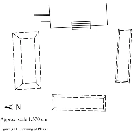
3.2.2 Plazas 64
3.2.2.1 Plaza 1 64
3.2.2.1.1 Structure 1-Este (‘Sistema R’) 65
3.2.2.2 Plaza 2 67
3.2.2.2.1 Structure 2-Este (‘Templo X’) 68
3.2.2.2.2 Structure 2-Oeste (‘Templo Y’) 69
3.2.2.3 Plaza 3 70
3.2.2.3.1 Structure 3-Este (‘Templo T-S’) 72
3.2.2.4 Plaza 4 72
3.2.3 Public Architecture 74
3.2.3.1 Temple T 74
3.2.3.2 Temple T-N 76
3.2.3.3 Structure R-Norte 78
3.2.3.4 Structure R-Sur (System R) 79
3.2.3.5 Structures A, B, and C 79
3.2.3.6 The main avenue (Ichi Iya) 80
3.3 Heritage assessment of the monumental core 81
3.3.1 Current State of the Site 82
3.3.2 INAH consolidation 83
3.3.3 Contemporary residences 85
3.4 Analysis 86
3.4.1 Relations between rulership and sacrality 90
3.4.2 Form 91
3.4.3 Location 97
4. Valley-based surveying in the Apoala Valley 103
4.1 Introduction 103
4.2 Ethnohistorical data on the Apoala Valley 105
4.3 Survey results 109
4.3.1 Tiki Tinduu Akama (AV1) 111
4.3.2 Tiki Kahua Akama (AV2) 112
4.3.3 Tiki Kahua Kuchindahua (AV3) 115
4.3.3.1 La Cueva (AV3a) 118
4.3.4 El Guerrero or Danzante del Kahua Laki (AV4) 118
4.3.5 Kahua Tidinuu (AV5) 120
4.3.6 Kahua Torri Kuaha (AV6) 121
4.3.7 Tinduu Va (AV7) 122
4.3.8 Yahui Che’en (AV8) 123
4.3.9 Sata Kahua Laki (AV9) 126
4.3.10 Toto Ndzaka (AV10) 126
4.3.11 Yuku Ñiñi (AV11) 129
4.3.12 Tinduu Toto Ñee (AV12) 129
4.3.13 Tinduu Ñuu Kuaa (AV13) 130
4.3.14 Yuku Andyishi (AV14) 131
4.3.15 Tiki Tinduu Ndodo Kimi- Yuku Andyishi (upper slope) (AV15) 132
4.3.16 Kahua Kandihui (AV16) 133
4.3.17 Ndodo Che – Centro Apoala (AV17) 134
4.3.18 Yahui Kaha – Centro (AV18) 135
4.3.19 Ndoko Yoo-Ofrenda a la luna (AV19) 136
4.3.20 Yahui Kahua Tidinuu (AV20) 138
4.3.21 Yahui Koo Maa (AV21) 138
4.4 Settlement dynamics 139
4.4.1 Early and Middle Cruz (Early Formative phase) Settlement 139 4.4.2 Late Formative (Late Cruz phase) Settlement 140 4.4.3 Ramos (Terminal Formative phase) Settlement 141
4.4.4 Las Flores (Classic phase) Settlement 142
4.4.5 Natividad (Postclassic phase) Settlement 144
4.4.6 Convento (Early Colonial phase) Settlement 147
4.5 Summary Survey data 147
part ii: present over past
5. Deconstructing Community Participation 149
5.1.1 Archaeological fieldwork and social context 150
5.1.2 Knowledge production in the field 151
5.2 Participation Dilemmas: A chronology of contact 152
5.2.1 Positionality in initiating participation 154
5.2.1.1 Political Office-holders 155
5.2.1.2 Santiago Tilantongo: Power of Authority 155
5.2.1.3 Santiago Apoala: Absence of Authority 159
5.2.1.4 Summary 162
5.2.2 Agency of social actors 162
5.2.2.1 Santiago Tilantongo: ‘Donde no hay agua’ 163 5.2.2.2 Santiago Apoala: ‘Santuario de la Mixteca’ 166
5.2.2.3 Summary 168
5.2.3 Positionality in collecting data 170
5.2.3.1 Mapping Monte Negro 170
5.2.4 Trust in the field 176
5.3 Conclusion 178
6. Constructing Landscape Narration 181
6.1 Introduction 181
6.1.1 Oral tradition 181
6.1.2 Archaeology and oral tradition in the Mixteca Alta 182
6.1.3 Landscape 184
6.1.3.1 Landscape archaeology 184
6.1.3.2 Landscape Studies in Mesoamerica 185
6.2 Landscape narration in the Mixteca Alta 186
6.2.1 Deep and recent times of the Cerro Negro landscape 186
6.2.1.1 Foundational symbolism of Monte Negro 188
6.2.1.2 The water paradox 189
6.2.1.3 Foundations 191
6.2.1.4 Summary 192
6.2.2 Mapping knowledge: Toponyms in the Apoala Valley 193
6.2.2.1 Mapping methodology 194
6.2.2.2 Classification of toponyms 198
6.2.2.3 Summary 199
6.3 Conclusion 200
7. Discussion and Conclusions 202
7.2 Discussion of key points 203
7.3 Landscape and authority 204
7.4 Conclusion 207
Epilogue 208
Appendix A: Conservation assessment forms (in Spanish) 210 Appendix B: Oral History recorded in Santiago Apoala 228 Appendix C: Oral history recorded in Santiago Tilantongo 231 Appendix D: Toponymic data recorded for the Apoala Valley 248 Appendix E: Ceramic Registration Forms Monte Negro (in Spanish) 255 Appendix F: Ceramic Registration Forms Apoala Valley (in Spanish) 283
Bibliography 335
Index 362
List of Figures
Figure 1.2 Chronological Chart of different Mesoamerican regions. 3
Figure 1.1 Map of Mesoamerica. 3
Figure 1.3 Villa Chalcatongo de Hidalgo. 8
Figure 2.1 Map of Oaxaca and the Oaxaca Valley
(modified from Marcus and Flannery 1996). 14
Figure 2.2 The Oaxaca Valley. 15
Figure 2.3 Map of the Mixteca, outlining the three sub-regions
(modified from Terraciano 2001). 16
Figure 2.4 Mixteca Alta landscape. 17
Figure 2.5 Severe gully erosion in the Mixteca Alta. 18 Figure 2.6 Santiago Tilantongo with Monte Negro in the background. 19
Figure 2.7 The Apoala Valley. 21
Figures 2.8 and 2.8a Canal irrigation in the Apoala Valley. 23
Figure 2.9 The monumental core of Monte Albán. 25
Figure 2.10 Early map of Monte Negro (Caso 1938). 31
Figure 2.11 Mapping at Monte Negro. 37
Figure 2.12 Surveying the Apoala Valley. 42
Figure 2.13 Surveying with guide in the Apoala Valley. 43 Figure 2.14 Esteban Avendaño (at left) at Monte Negro. 50 Figure 3.2 Aerial photograph of Cerro Negro, centrally showing Monte Negro. 53 Figure 3.1 Map of Cerro Negro (modified from INEGI E14D35). 53
Figure 3.3 Drawing of Residential Unit 1. 56
Figure 3.4 Drawing of Residential Unit 2. 57
Figure 3.5 Residential Unit 2. 57
Figure 3.6 Drawing of Residential Unit 3. 59
Figure 3.7 Drawing of Residential Unit 3 (as illustrated in Acosta & Romero 1992). 59
Figure 3.8 Drawing of Residential Units 4 and 5. 60
Figure 3.9 Drawing of Residential Unit 7. 62
Figure 3.10 Drawing of Residential Unit 7 (as illustrated in Acosta & Romero 1992). 62
Figure 3.11 Drawing of Plaza 1. 65
List of Tables
Figure 3.12 Drawing of Plaza 2. 67 Figure 3.13 Drawing of Structure 2-Este (‘Templo X’). 68
Figure 3.14 Drawing of Plaza 3. 71
Figure 3.15 Structure 3-Este (‘Templo T-S’). 71
Figure 3.16 Drawing of Plaza 4. 73
Figure 3.17 Temple T. 75
Figure 3.18 Drawing of Temple T-N (as illustrated in Acosta & Romero 1992). 76
Figure 3.19 The main causeway ‘Ichi Iya’. 80
Figure 3.20 Artemio Hernandez G. and Taurino Hernández C.
consolidating Residential Unit 3. 83
Figure 3.21 Joke de Vrieze consolidating Residential Unit 3. 84
Figure 3.22 Contemporary residences at Monte Negro. 85
Figure 3.23 Stone carving on structure Temple T. 93
Figure 3.24 Plaza 4, seen from northeast corner. 95
Figure 3.25 Drawing of North section. 96
Figure 3.26 Drawing of Residential Units at Monte Negro. 98
Figure 3.27 Unit 5, seen from Structure 3-Oeste. 98
Figure 3.28 Drawing of Temple Z showing architectural ties to Structure 1-Este. 100
Figure 3.29 Drawing of Temple T-N. 100
Figure 4.1 The Apoala Valley. 104
Figure 4.1a Map of the Apoala Valley (modified from INEGI E14D26). 105 Figure 4.2 Detail from Codex Zouche-Nuttall, Page 36
(modified from Anders et al. 1992b). 106
Figure 4.2a Codex Zouche/Nuttall, Page 36, depicting the Apoala Valley
(modified from Anders et al. 1992b). 107
Figure 4.3 General map Tiki Tinduu Akama (AV1). 112
Figure 4.4 General map Tiki Kahua Akama (AV2). 113
Figure 4.5 Panoramic view of Tiki Kahua Akama. 115
Figure 4.6 Boulders that characterize Tiki Kahua Akama’s landscape. 115 Figure 4.7 View of the Apoala Valley featuring the Tiki Kahua Kuchindahua
peaks in the central background. 116
Figure 4.8 General map Tiki Kahua Kuchindahua (AV3). 116 Figure 4.9 Well preserved defensive walls at north side Tiki Kahua Kuchindahua. 117 Figure 4.10 Rock carving, known locally as ‘El Guerrero’ or ‘El Danzante’. 119
Figure 4.11 Drawing of ‘El Guerrero’ rock carving. 119
Figure 4.12 Rock art with black paint at Kahua Torri Kahua (AV6). 120
Figure 4.13 Map of Tinduu Va (AV7). 121
Figure 4.15 The southern end of the Apoala valley showing the extensive terracing
of Yahui Che’en in the background (AV8). 123
Figure 4.16 Yanhuitlan Red on Cream sherds. 124
Figure 4.17 Eagle or vulture tripod vessel support in Miguelito Hard Grey. 125 Figure 4.18 Yanhuitlan Red on Cream subhemispherical bowl at
Toto Ndzaka (AV10). 127
Figure 4.19 Panoramic view of Tiki Tinduu Ndodo Kimi (AV15),
seen from northeast. 131
Figure 4.20 Alignments of worked stone at Tiki Tinduu Ndodo Kimi (AV15). 132 Figure 4.21 Boulders dot a path granting access to Kahua Kandihui (AV16). 133 Figure 4.22 Semi- or complete vessels in a private collection from
the Ndodo Che site (AV17). 135
Figure 4.23 Basalt instrument, potentially utilized in the production of amate paper. 135 Figure 4.24 Rock art with white paint at Ndoko Yoo (AV19). 137
Figure 4.25 Ramos Phase site sizes. 140
Figure 4.26 Las Flores Phase site sizes. 143
Figure 4.27 Natividad Phase site sizes. 145
Figure 5.1 Municipal sign of Santiago Apoala, on the main entry road
from Nochixtlan. 158
Figure 5.2 Laura Van Broekhoven in a communal meeting in front of the
municipal building at Santiago Tilantongo. 164
Figure 5.3 Communal meeting on the church lawn at Santiago Apoala. 168 Figure 5.4 The Parador Turistico ‘Ve’e Turista Yutsa To’on’ in Santiago Apoala. 169 Figure 5.5 Communal meeting in the Monte Negro primary school building. 174 Figure 5.6 Dialogue during a communal tour of the Monte Negro site. 175 Figure 6.1 Laura Van Broekhoven discussing the Apoala political landscape at one
of several stone border posts, or mojoneras. 187
Figure 6.2 Conducting the toponymic survey around Monte Negro. 187 Figure 6.3 A House of Water (Vehe Savi) on Cerro Negro,
near the Monte Negro site. 190
Figure 6.4 Consulting the map during the toponymic survey in the Apoala Valley. 195 Figure 6.5 Processing toponymic data with local partners. 196 Figure 6.6 Sample of photographic representation of narrated landscape in
Lucky circumstances put me in contact with many residents of Santiago Tilantongo and San-tiago Apoala. This includes those who had to engage with the ideas expressed in this book due to their municipal cargo, as well as those wanting to discuss local history because of their personal interests. All have been of exceptional value for indicating the value of listening to different voices in this research. Sure enough, not all can be mentioned, but for Tilantongo in particular I include Don Artemio Hernandez Gutiérrez; Don Taurino Hernandez Cruz; Doña Ester Gutiérrez Montesimos; and former municipal president Eleazár Pedro Santiago. In Apoala I benefited from conversations with Margarito López Hernández; Don Leopoldo Guzmán Al-varado; Don Antonio Guzmán Gutiérrez; Don Isauro López López; Don Alvaro Ramos López; Doña Otilia Jimenez López; Don Ventura Hernández; Don Gilberto López; Doña Justa Serapia Guzmán; Doña Francisca García López, Doña Liberia García; Doña Tina Ramos; Doña Ama-lia Hernández López; Don Guillermo López Pacheco; Doña Apolinaria López Pérez; Don Roel García Santiago; Don Mario Jiménez López; and Don Alvaro Guzmán. Also, de manera muy especial: Don Prisciliano Alvarado; Don Ubaldo López Garcia and former municipal adminis-trator Renato Luis Esperanza helped shape the project into what it would become.
The material and financial support of the Research School CNWS for Asian, African and Amerindian Studies and the Netherlands Foundation for Scientific Research (NWO) is ac-knowledged. The archaeological findings reported on are the result of a voluntary participation in research directed by INAH, under direct and continuous supervision of the regional centre in Oaxaca, within a framework of cooperation between the Centro INAH-Oaxaca and the Faculty of Archaeology of Leiden University. The former director of the Centro INAH-Oaxaca Eduardo López Calzada enthusiastically engaged in this cooperation and facilitated the Facul-ty’s proposals to assist in the development of this project. Nelly Róbles García, the director of the Monte Albán Archaeological Zone, together with her crew provided valuable orientations and equipment regarding the work at Monte Negro. Raul Matadamas Diaz was an insightful colleague and loyal companion on many trips in the Mixteca. He, together with his wonderful family received me and many others with open arms in Oaxaca.
Several archaeology students participated in this research between 1998 and 2004. Ivan Kisjes; Joke de Vriese; Enrique García García; Tom Hos; Shu-li Wang; Pieter Teekens; Sandra Warning; Evelien Pater; and Alessia Frassani are thanked for their dedicated work. A special thank you is given to Ivan and Enrique, who have contributed significantly to the descriptive work of Monte Negro. Alexander Vinkeles Melchers is thanked for his valuable assistance re-garding several illustrations.
Rivera Guzman; John Bintliff; Juan-Julian Caballero; Manuel Rios Morales; Michael Swanton; Miguel-John Versluys; Sabine Luning; and in particular the Van Broekhoven family. An honor-ary 1-4-3 Club Member, Rivke Jaffe aided considerably in covering up some of my anthropo-logical shortcomings, many thanks to her.
Finally, I thank my parents for their unconditional and unrelenting support over the years. I hope the present book is as much a meaningful result for them as it is to me.
Introduction
‘Archaeologists can no longer ignore the components of the contemporary social context that is articulated with the archaeological resource. In this sense, we can no longer deny the need to be sensitive and receptive to the communities around us.’
- Nelly Robles García (1998)
1.1 Introduction
It is the aim of this dissertation to describe the praxis of participatory archaeology in the Mixteca Alta, Oaxaca, Mexico, featured through the case-studies of research conducted in the communities of Santiago Tilantongo and Santiago Apoala. In each case, the specific social con-texts of participatory approaches that featured in the activities are analyzed and subsequently related to a reflection on the concept of participatory archaeology in settings of descendant communities. In doing so, local power relations and issues of representation in these projects are identified.
The past and contemporary nature of the archaeological praxis in the Mixteca Alta has had negative consequences for participatory research. Increasingly, a process of negative image building is noticeable in the region, in which archaeology has not been capable of recognizing the importance of indigenous collaboration, other than for motifs of multicultural diplomacy. Incentives for collaboration have occurred, but in a high number of cases these efforts were halted due to conflicting interests between the participating parties.
archaeological projects, many of which go under the heading of ‘community archaeology’, are in need of similar reflexive analysis of their field activities in order to exclude idealized and thus unthinking narratives of a harmonious archaeological praxis.
The argument, as outlined by the individual chapters, follows a narrative course that reflects the process of increasing awareness of the author’s own positionality, whereby early chapters present a objectifying narrative consistent with the regional archaeological tradition focused on materialist analysis of surface artifacts ranging from the Late Formative to the Postclassic period (300 BC – AD 151) through survey and mapping. Based on a reflexive analysis of the participatory elements and local power relations recognized in them, the subsequent chapters explore alternative means for embedding the production of historical knowledge in local per-ceptions of landscape and monuments.
Landscape as a spatial concept is seen here as a local sphere of interest, that holds a recur-sive relationship to its inhabitants manifested through narrated histories in both pre-colonial pictographic documents and contemporary oral tradition. This has, for example, allowed for the integration of locally meaningful natural features in archaeological analyses. Ultimately, integrating oral tradition in participatory partnerships leaves behind the notion of a normative past, and represents an opportunity for ethically valid and socially valuable research for both archaeology and descendant community.
1.1.1 Mesoamerican cultural backdrop
The pre-colonial cultural developments in Santiago Tilantongo and Santiago Apoala, and more widely in the Mixteca Alta take shape against the background of the Mesoamerican culture area (Figure 1.1). Mesoamerica as a culture area was introduced in 1943 by Paul Kirchhoff as part of a wider scheme of culture areas covering the American continent, and was delimited based on cultural characteristics and ethnic composition at the time of the Spanish Conquest (Kirchhoff 1943). Despite a range of critiques as to the epistemic value of the culture area concept (recently by Carmack et al 1996 and López Austin and López Lujan 1996) it currently still remains the main geo-cultural reference for situating research into pre-and postcolonial material culture and history and will be used accordingly in this text. Most recently, defining Mesoamerican features were listed as: 1) a basic structuring economy; ) worldview and related ritual practice; and 3) materialized social stratification (Joyce 004a:3). In this sense, the Mixteca Alta and more generally Oaxaca, have quickly become one of the most defining regions of Mesoamerica, since systematic archaeological studies were initiated in the first half of the twentieth century (Paddock 1966).
National Borders Mesoamerica
0 800 km N
➣
Figure 1.1 Map of Mesoamerica.
particularly across regions of Central Mexico, Oaxaca, and the Gulf Coast. Specifically in the latter area (i.e. San Lorenzo), in combination with the coastal region of the modern Mexican and Guatemalan border (i.e. Mokaya), complex societies take shape during this period. An, at first modest and then gradually more marked, increase in population is registered in regions across Mesoamerica and the Mixteca Alta during the Cruz Phase (1500 – 300 BC) appears to equally take part in this process (Spores 1983e). In the Mixteca, the Middle Formative is fol-lowed by the Late Formative Ramos Phase (300 BC – AD 00/300), a time of drastic changes in settlement patterns throughout the Mixteca Alta and political hierarchies that rapidly in-crease in complexity. Mobility and exchange systems expand and become an integral part of society. The foundation of Monte Albán in the Oaxaca Valley around 500 BC and its susbse-quent explosive growth, does not remain without impact in the Mixteca Alta: this is the period when the process of urbanization is initiated in the region, exemplified in the archaeological record by early urban centers such as Yucuita in the Nochixtlán Valley. The valley in which Santiago Tilantongo would much later be founded is one of the areas in the Mixteca Alta that experiences this early urban growth, resulting in the relatively short occupation of the Monte Negro site.
Postclassic period (Marcus 1989). This trend is one of the leading motifs of the Mesoamerica Epiclassic period that preceded Postclassic times.
The Postclassic is represented in the Mixteca Alta by the Natividad Phase (AD 900 – 151), which in fact still is imbalanced by an overwhelming reliance on Postclassic ceramic types ap-pearing in the second half of the period. The Postclassic period is also the time of florescence of Tilantongo, as attested by numerous 16th century historical sources as well as abundant
refer-ences in Late Postclassic pictorial manuscripts which place emphasis on the regional influence of its powerful political elite (cf. Anders et al. 199a,b; Acuña 1984; Burgoa 1934 [1678]; Jansen and Perez Jimenez 005; Reyes 1976 [1593]). Other than Tilantongo, such historically lauded centers of power are Coixtlahuaca; Teposcolula; Tututepec; Achiutla and Tlaxiaco, among a few others, but only the first three convincingly reflect the historical reports in their Natividad archaeological record (cf. Bernal 1948; Joyce et al. 004; Spores and Robles in press, Spores 1993; Stiver 001). Overall, the Natividad adheres to the trend for increasing interaction and mobility seen throughout Mesoamerica (Ball and Brockington 1978, Gutiérrez Mendoza 000; Gutiérrez Mendoza and van Rossum 006; Jansen et al. 1998); contact maintained through extensive networks of roads and paths that were eventually also used by the Spanish and their indigenous counterparts (Hassig 1985:171-19; Rees 1975; Sousa and Terraciano 003). The Postclassic ends historically with the arrival of the Spanish and the conquest of the Mexica capital Tenochtitlán in 151. In the Mixteca Alta, cultural continuity seems to provide in a more accurate description of the period than the dominant image of Spanish Conquest normally evokes. The archaeological record, and in particular ceramic production, contin-ues relatively undisturbed for several decades, before eventually beginning to show substantial change over the introduction of Spanish Colonial material culture. The Early Colonial Con-vento phase thus also shows significant overlap in style and diagnostics with its (as mentioned predominantly Late Postclassic) Natividad predecessor. Changes are first seen in iconography in, for example, the transition from Pilitas to Iglesia Vieja polychrome ceramics (Lind 1987). Eventually, in the latter half of the sixteenth century an increasing influence of the Spanish political and religious administration is seen that has its effect on the settlement pattern, thereby ending one of the primary indicators for archaeological analysis and the pre-colonial landscape of the Mixteca Alta.
1.1.2 Site-based and Valley-based archaeology
Settlement-based research in Oaxaca is well-developed and continues to be one of the primary ways for conducting archaeology, with frequently small numbers of sites being sub-jected to excavation in the Oaxaca Valley and the Mixteca (recent examples include Blomster 004; Feinman and Nicholas 004; Finsten 1995; Heredia Espinoza 005; King 003; Pérez Rodríguez 003; Spores and Robles in press; Sherman 005; Workinger 00).
Far less common are site-based projects in Oaxaca that also involve a heritage management aspect; the most established example of this approach being the Monte Albán Archaeological Zone. Monte Albán is the only UNESCO World Heritage Site in the state, and numerous heritage initiatives have developed at the site over the last 0 years, overshadowing any of the other sites in Oaxaca linked in some way to heritage management projects. Other than those based on communitarian museums, no heritage projects initiated by non-local partners have developed in communities.
In terms of community involvement, a drawback of site management is that it often entails activities of preservation and as a result thereof, the site is often divorced from its contemporary local functions. This leads to the apparent severing of existing ties between the nearby com-munity and the site itself, which is then increasingly associated with state policies born from preservation measures. Alternative scenarios are possible though, and heritage management does not, however, necessarily lead to this separation: case studies of site-based heritage manage-ment projects from Mesoamerica and other areas of the world can be named that focus more on the incorporation of local values that are then invested in the site and where pragmatic avenues of protecting the site are sought (Grimwade and Carter 000; Breglia 005). The contrast of smaller and thus monumentally arguably less impacting sites to a site like Monte Albán, located next to the state capital and attracting 100,000s of visitors on a yearly basis, is obvious, but this difference in size makes conservation of smaller sites, like many of those in the Mixteca Alta, even more desirable in light of their local value and position in the cultural landscape. In many of the regional archaeological projects, valleys form a natural setting, a preference that goes back to the origins of settlement pattern surveys in the Americas (cf. Willey 1953) and its early applications in Mesoamerica (MacNeish 197; Sanders et al. 1979). Central to many of these studies is the concept of cultural ecology (Kowalewski and Finsten 1983; Sanders and Nichols 1988), being the identification and study of processes by which a human group adapts to a particular social and natural environment (Steward 1955:40-4). This has pushed archaeologists active in Oaxaca to develop strategies enabling the production of comprehensive explanatory models regarding cultural continuity and change. For Oaxaca, this has resulted in the increased application of anthropological as well as ethnohistorical data from more recent periods.
Postclassic period and the transition to the early Colonial period or in some cases contemporary times through ethnoarchaeological research. This linking of data from one period to explain processes in an earlier one is part of a long tradition in Valley-based research in the Mixteca Alta and started with the Nochixtlán Valley Project. This project explicitly outlined the application of the direct historical approach in its methodology (Spores 197). More recent continuations of this line of interdisciplinary research are projects undertaken in the Oaxaca Valley and on the Oaxaca coast (Gutiérrez Mendoza 000, 00; Jansen et al. 1998; Kröfges 006; Zeitlin 1991, Joyce et al. 004). In all, valley-based research has thus proven to be a common setting for archaeological research in Oaxaca (recent examples include Balkansky 1998b; Feinman and Nicholas 1999; Stiver 001; Winter 1996; and Balkansky et al. 000, with the difference that this latter research incorporated multiple valleys).
1.2 Objectives
The choice to conduct the archaeological activities in the municipal territories of Santiago Tilantongo and Santiago Apoala had its origin in two written applications of the respective political authorities at the regional office of the National Institute of Anthropology and His-tory (herafter Centro INAH-Oaxaca) for an archaeological investigation. Leiden University through the Faculty of Archaeology and this author subsequently became involved due to a formal agreement of collaboration with the Centro INAH-Oaxaca. The parameters set for this agreement outlined the triangle of local community-Centro INAH-Oaxaca-Faculty of Archeology, and explicitly put the emphasis on community-based initiatives for conducting the archaeological research.
1.2.1 Participatory archaeology
Apart from these archaeological results however, inhabitants of Chalcatongo or Yosondúa did not fill any role of significance in the fieldwork. The two field campaigns were conducted by a team consisting of four persons and they used a rented house at the outskirts of the municipal centre for housing and processing of the collected data. Despite the fact that the level of Span-ish language proficiency of all the participants, excluding the Mexican field director, was below many standards for meaningful communication, this did not result in any limitations for the project as it took its course. In other words, no communication with the local community was required, nor sought.
Interaction with the municipal authorities was limited to the initial phase of the project, and consisted of cordial visits to the municipal president in order to present the project and formally request permission for the field activities and lodging in the community. Although these meetings were filled with elegant semantics, no factual initiative for input (other than
agreeing or disagreeing to the project) was debated in these conferrals. In later stages of the project, it became virtually impossible to meet up with any of the representatives of the authori-ties, who commonly were not to be found at the municipal building, evidencing the lack of participation. Moreover, the popular approval of the authorities in Chalcatongo was low and our scarce meetings with them were viewed with indifference or even mistrust. Meetings with other municipal authorities in surrounding communities took on a similar character, reaching instances where it was implicitly advised not to speak to the authorities at all. As said, the lack of communication did not affect the objectives of these two field campaigns, but it did represent a moral lacuna in the overall field research.
The abovementioned provided for one of the problems addressed in case-studies of the archaeological activities undertaken in Santiago Tilantongo and Santiago Apoala. As such, a contribution is sought to the growing debate of ethics in archaeological fieldwork. Ethical con-siderations in archaeology have in recent years seen a significant increase in publications (e.g. Green 1984; Lynott and Wylie 1995; Meskell and Pels 005; Scarre and Scarre 006; Vitelli 1996), and are characterized by attempts to outline ethically ‘good practice’ as well as attempts at probing ethical dynamics during archaeological fieldwork. The heterogeneity of contem-porary cultural settings against which this fieldwork takes place, has proven to be a difficult element to reconcile with the establishment of guidelines for practicing archaeologists. These settings range from urbanized areas where building contractors; local or supra-local governing bodies; and other local stakeholders are involved in the archaeological fieldwork, to rural set-tings where comparable supra-local bodies fill very different social roles and local political actors may have a determining voice in the archaeological activities. Stakeholders in material culture, based on their cultural association to these materials represent a further dimension of influence on the archaeological praxis.
The present study is primarily concerned with the latter two scenarios that intertwine in the regional setting of the Mixteca Alta, and it seeks to evaluate participatory approaches, such as that of the ‘community archaeology’ (see Chapter Two). Finally, it looks to add to existing debates on the present and future of archaeological praxis in Mexican stakeholder settings. Archaeology in Oaxaca, and in particular in the Mixteca Alta, is a field traditionally charac-terized by an emphasis on regional survey in order to seek understanding into socio-political development during pre-colonial times, and this study seeks to illuminate the praxis in which these understandings are reached.
1.2.2 Monte Negro Mapping and Heritage
functionality. Part of this inquiry into functionality will be an analysis of spatial order in the architecture visible on the surface. It will be argued that from this architectural layout, infer-ences can be made about the social position of rulership in relation to sacredness during Late Formative times at Monte Negro.
In order to obtain an understanding of the state of conservation, all the architecture visible on the surface will be mapped, thereby establishing an inventory of damages to the structures in the core area. In this inventory numerous types of damages are recorded and assessed in terms of graveness and possible urgency of consolidation. The management of this monumental site with archaeological features is rare for the Oaxacan region and an architectural character previ-ously noted for its uniqueness is a second point of emphasis in the field. It is thus a concern for this research to provide advice on how to maintain it materially sound and safeguard it from additional damages in the future.
1.2.3 The Apoala Valley survey
The principal aim of the Apoala Valley survey is to register all archaeological remains in the project area, which is defined by the limits of the Apoala municipal grounds. This includes registration, description, and mapping of the extant archaeological sites. An additional goal included in the process of mapping these sites is the proposition of site boundaries. These registering activities assist in the ongoing INAH project for the development of an updated state-wide database on archaeological sites (García García and Palacios González 1976). In do-ing so, particular attention will be given to determindo-ing the nature of the regional relationship to the nearby Cuicatlán Cañada and Nochixtlán Valley. A focus on the nature of interregional interaction with the Oaxaca Valley is not considered a primary goal for the survey in light of the small size of the covered area relative to previously surveyed areas that did address this question (see also Chapter Two).
A following objective is to collect information about toponyms or place-names in the Mix-tec language still now in use in the Apoala Valley. Examples may include terrains; hilltops; monolithic rocks; caves; stones; and other known locales. This element of the research is to be conducted in collaboration with community members in order to establish a map of the toponyms coordinated by the municipality of Santiago Apoala.
Finally, the third research goal is to conduct a survey of the valley to create an overview of contemporary agricultural activities. As the natural surroundings are marked by a high degree of fertility by the year-round flowing Apoala River, the irrigation system features have developed into a complex network of main streams and side branches reaching into the remote pockets of the valley floor (Geurds and Van Broekhoven 003, 006; for a comparable example from the Oaxaca Valley see Lees 1973).
1.2.4 Organization of the thesis
Following this introductory chapter, Chapter Two will be dedicated to presenting the geograph-ical characteristics of the Mixteca Alta and some relevant neighboring regions, as well as include an introduction to the archaeological investigation that helped shape the current knowledge of pre-colonial developments. Following this will be the methods employed in the archaeological research in addition to a summary of the ceramic chronology used for the Mixteca Alta. After this, the thesis discussed is divided into two parts: Part I consists of two chapters detailing the execution and results of the mentioned research in Santiago Tilantongo and Apoala, which are structured in the following way: Chapter Three discusses the surface architecture of Monte Ne-gro. After an overview of existing research at and ideas on the local and regional role of Monte Negro, the monumental features will be described and analyzed with regard to the distinction between residential and non-residential architecture. Lastly, a conservation assessment of several of the structures in the core area of the site is given in which proposals are made to ensure the continuing preservation of the structures.
Chapter Four describes the inventory of sites registered in the Apoala Valley, after having highlighted some elements of Apoala history as recorded during the Late Postclassic and Colo-nial periods in ethnohistorical sources. On the basis of the site inventory, a habitation history of the valley is reconstructed that ranges from the Formative to Colonial periods. Finally an interpretation of the settlement dynamics from the Formative to the Postclassic period in the valley is provided.
archaeological research. The chapter goes on to illustrate the social dynamics of participatory ar-chaeology through examining personal views on the historicity of the Monte Negro and Apoala Valley surroundings. From this, it will become clear that the participatory praxis of archaeology involves issues of trust and therefore mutual obligations. These dynamics are often oversimpli-fied and romanticized in current description of participatory forms of archaeology, like that of the community archaeology. These obligations are problematic and must be presaged when building partnership in local contexts. The primary conclusion is that the construction of local history in both Monte Negro and the Apoala Valley is intimately linked to landscape features. These features are not exclusively archaeological sites, but may also be natural places; lacking any material culture. Stories are articulated that alter these landscape features by naming them and weaving them into particular narrative elements.
Chapter Six proposes the incorporation of oral tradition in participatory archaeology as a locally present body of historical data that can be of relevance to the overall research questions of the given project. Contained in oral tradition, the concept of landscape is introduced as an epistemic canvas of memory used by both archaeology and local community for generating knowledge regarding history. It is proposed here that both the study of toponyms as well as stories provide entry points into this narrated landscape that can serve as a more comprehen-sive methodology and enable a synthesis of knowledge by both participating partners through dialogue and searching for truths.
Background, Methods, and Approach
2.1 Geographical and Cultural Backdrop
The archaeological materials reflected on in this book originate from several regions neighbor-ing the Mixteca, such as the Oaxaca Valley and the Cuicatlán Cañada. This warrants a geo-graphical description that briefly elucidates the primary geogeo-graphical features of these regions, before detailing the geography of the Mixteca Alta.
2.1.1 Oaxaca
Largely located between 5º40’ and 8º40’ degrees North Latitude and 93º40’ and 98º35’ West
Longitude, the modern state of Oaxaca is marked by significant diversity, in terms of geography as well as flora and fauna (Figure 2.). Physiographically, Oaxaca is situated between a neovol-canic plateau to the northwest and the Isthmus of Tehuantepec to the southeast. Its geology has been argued to be one of the most complex in Mexico (Ferrusquia-Villafranca 97: 4). Topography is determined by the two major mountain systems of the Sierra Madre del Sur and the Sierra Madre Oriental which make contact in Oaxaca; causing a majority of terrains that are quite rugged, many of which are slightly or severely affected by soil erosion. Elevation ranges from the Pacific coastal stretch up to over 3200 meters for the highest peaks inland. The topographic fragmentation sketched above has created numerous climatic and biological niches, such as cloud forest, savanna and pine forest habitats. The fragmented nature of Oaxaca is often cited as the primary causal factor for the cultural and linguistic diversity seen during pre-colonial times as well as in current day expressions of culture in Oaxaca (Monaghan 994). The Mixteca Alta is characterized by the typical reddish earths of the Yanhuitlán Beds that underlie for example the Nochixtlán Valley (Kirkby 972).
Besides speakers of Zapotec, located in the centre and eastern part of the state, speakers of Mixtec culture occupy a central role in the Oaxacan cultural spectrum and are predominantly located east of the Oaxaca Valley in the Mixteca. Scattered throughout the mountains, small agriculturally attractive highland valleys are found, some of which have significant sizes. The Oaxaca coast is marked by fertile coastal flatlands. The largest of agriculturally productive ter-rains however, is the Oaxaca Valley.
The Oaxaca Valley is the single largest area of flat alluvial grounds in Oaxaca, and features the Salado and Atoyac Rivers draining the valley floor at a mean altitude of 600 meters above sea level (Figure 2.2). Mean temperature is around 20º degrees Celsius and precipitation is 500
to 850 mm on average per year depending on the location in the valley (Garvin 994: Table 2.5). Both rivers meet near the modern state capital Oaxaca de Juarez. The Formative period human occupation of the valley has been researched exhaustively and goes back to at least 3500 years BP (Drennan 976; Fisch 982; Flannery 976a, 986; Flannery and Spores 983; Flannery and Marcus 2000; Marcus 983c; Pires-Ferreira 975; Whalen 976). Speakers of Zapotec have been the dominant people in the Valley in the past and still today represent a large majority of indigenous language speakers, along with a somewhat smaller number of Mixtec
Tehuacán Valley Cuicatlan
Cañada
Yanhuitlán Nochixtlán Apoala
Tututepec
Oaxaca City
Monte Albán PUEBLA
VERACRUZ
GUERRER O
Pacific Ocean
km
0 50 100
Tilantongo
Monte Negro
speakers. Cultural development in the Oaxaca Valley culminated in the genesis of one of the earliest examples of the early state in Mesoamerica, with the foundation of the Monte Albán settlement dated at 500 BC (Blanton 976; 983a). Monte Albán would undergo explosive growth during its period I and subsequently exert influence on other areas of Oaxaca, including the Cuicatlán Cañada. This influence is primarily attested through traces of material interac-tion and scenarios of conflict and conquest (Balkansky 2002; Blanton et al. 999; Marcus 976, 983; Payerón Moreno 960; Redmond and Spencer 983; Spencer 982; Spencer and Redmond 997, 200a,b), and the nature and extension of Monte Albán influence has been a debated issue (Mason et al. 977; O’Brien and Lewarch 992; O’Brien et al. 989; Urcid 2000; Workinger 2002; Zeitlin 990; Zeitlin and Joyce 999).
The Cuicatlán Cañada is situated north of the Oaxaca Valley and northeast of the Mixteca Alta and is formed by a canyon with the Río Grande draining it in a northwestern direction toward the Tehuacán Valley. Altitudes are substantially lower here than in the Oaxaca Valley and do not exceed 700 meters above sea level. Mean temperatures are thus also significantly higher
than in the Oaxaca Valley, averaging around 25º degrees Celsius. Precipitation in the Cañada
is on average around 400 mm per year (Rodrigo 997). Cultural ties between the Cuicatlán Cañada and the Oaxaca Valley materialized during the period of Monte Albán growth (Cruz Vasquez 999; Spencer and Redmond 200b); connections to the neighboring Mixteca Alta though, are far less clear pronounced in the material record.
2.1.2 Mixteca Alta
Th e Mixteca Alta forms part of a three-fold regional division of the Mixteca area, the other two being the Mixteca Baja and the Mixteca de la Costa (Figure 2.3). It is largely populated by eth-nic Mixtec, but also includes speakers of other languages pertaining to the Otomanguean lan-guage family, such as Trique, Amuzgo, Chatino, Chocho and Popoloca, as well as few
remain-PACIFIC OCEAN
0 20 40 60 km
N Alta Baja Costa
➣
Oaxaca Cuicatlan Huajuapan Tututepec Apoala Coixtlahuaca Yanhuitlan Nochixtlan Teozacualco Chalcatongo Tlaxiaco Achiutla Tilantongoing speakers of Ixcatec. Despite the longstanding and widespread reference to these three areas, the precise regional bounda-ries have not been defi ned and remain somewhat debatable. Mean altitude however, seems to be a central delimiting feature. Roughly speaking, the Mixteca Baja is located to the northwest of the Mixteca Alta, reaching and overlapping some-what into the neighboring modern states of Puebla and Guerrero, and ter-rains are lower (on average between 800 and 600 meters above sea level)
and thus warmer and dryer on average than in the Alta. The Mixteca de la Costa is determined by the coastal strip starting in the west around the border with Guerrero and continuing on to the coastline of the Isthmus of Tehuantepec. Leading inland, height is the determining factor, where 750 meters above sea level provides the border to the Mixteca Alta (Spores 984: ). The Mixteca de la Costa annually receives much more rainfall than the Alta or the Baja combined. This is due to meteorological depressions that float in from the Pacific Ocean and deposit the bulk of rainfall before passing the southernmost mountains of the Alta. Annual rainfall has reported to be over 2200 mm in some places (Rodrigo 997).
The Mixteca Alta features several valleys at valley floor altitudes of on average around 2000 meters above sea level. These valleys can be divided in primary and secondary valleys based on their relative sizes. Most of the valleys are quite narrow and have a limited amount of arable alluvium, with piedmonts rising at steep inclinations (Figure 2.4). As a result, environmental diversity is abundant in the Mixteca Alta (Smith 976). The largest primary valley is the cen-trally located Nochixtlán Valley, which was a major habitation zone during the entire pre-co-lonial sequence (Spores 972, 974a), and the only valley that supports year-round agriculture (Kirkby 972). The Nochixtlán Valley is neighbored to the west by the smaller Tamazulapan and Teposcolula Valley. The former directly connects to the Mixteca Baja; the latter is the principal access to the central and southern parts of the Mixteca Alta. To the southeast of the Teposcolula Valley, the area of Tilantongo and Jaltepec is located that incorporates the Monte
Negro mountain, subject of discussion of this book. North of the Nochixtlán Valley, the Apoala Valley does not link directly south to the Mixteca Alta’s primary valley and is substantially smaller still than the mentioned Teposcolula and Tamazulapan secondary valleys. Further to the south, the Mixteca Alta is defined by the secondary valleys of Tlaxiaco, Chalcatongo and Achiutla Valleys. The Tlaxiaco, Teposcolula and Nochixtlán valleys are now marked by the re-gions largest urbanized cities, with the city of Tlaxiaco (7º5’40’’ North Latitude, 97º40’50’’
West Longitude) and Nochixtlán (7º28’20’’ North Latitude, 97º3’50’’ West Longitude) being
the most populous in the Alta. The Chalcatongo Valley, with Villa Chalcatongo de Hidalgo as its main town (7º02’00’’ North Latitude, 97º36’00’’ West Longitude), is irregular in shape
and wider than some of the other secondary valleys, with low hills protruding the valley floor and valley width changing as it snakes southward to the modern town of Santiago Yosondúa (6º5’55’’ North Latitude, 97º34’0’’ West Longitude). Additional valleys are those of
Coix-tlahuaca, JuxCoix-tlahuaca, and Yanhuitlán.
Given the altitude of the area, vegetation in the Mixteca Alta includes patches of conifer-ous forest, along with several other dominant plant species such as numerconifer-ous species of pine trees (Pinus sp); oak trees (Quercus sp); Juniper (Juniper flaccida); Mulberry (Morus celtidifolia); Maguey (Agave sp); prickly pear (Opuntia sp); and Biznaga (Echinocactus viznaga). In addition, numerous fruit plants are cultured in some of the more fertile valley floors. Dominant culti-vated crop plants are corn (Zea mays); wheat (Triticum sp); beans (Phaseolus sp); and squash
(Cucurbita sp). Some of the primary minerals to be found in the Alta are listed by Spores (984:2) as being basalt, chert, gold, limestone, mica, and salt.
Today, the vegetation of the Mixteca Alta, particularly in the primary valleys has changed substantially from pre-colonial times. Demand of wood for combustion and construction has cleared large segments of the forest-like flora, affecting both geological processes as well as current flora and fauna. Erosion is one of the most visible and concerning developments from partially caused by these activities (see Joyce and Mueller 997 for an analysis regarding the Mixteca de la Costa). Fauna has also been affected by the above and through hunting, and the list of currently endangered or even extinct larger species includes felines, deer, fox, coyote and squirrel among many others (Figure 2.5).
2.1.3 Monte Negro
The archaeological site of Monte Negro and the community bearing the same name are located on the hilltop of the Cerro Negro, just south of the municipal centre of Santiago Tilantongo in the Tilantongo-Jaltepec area (Figure 2.6). Santiago Tilantongo is a contemporary community with approximately 200 inhabitants, located just south of the Nochixtlán Valley. The site pertains to the pattern of human settlement that had its impact mostly in the Tilantongo area to the north, and seemingly much less so toward Achiutla and Tlacotepec to the south. The rugged topography most likely provided the natural boundary for intensive human interaction
that might have reflected in the settlement pattern. The modern residents on the Cerro Negro hilltop, close to the Monte Negro site, are a reduced number of Mixtec speaking families that build their livelihood from temporal agriculture, with most inhabitants working the land dur-ing the summer months. As we were told, the families that live in the area at this moment, only moved there relatively recently, during the years Alfonso Caso initiated his field campaigns. In addition, individual households practice commerce either through stores or on the Tilantongo marketplace on Sundays. The connection to the regional infrastructure is fairly weak, for access to the community remains by means of a number of dirt roads leading in different directions. With the central part of the community located on one of the small hills of the surrounding valley, many people have residences either in the centre itself or in the centre with secondary houses at the foot of the hill. Inhabitants of the surrounding agencias (subsidiary communities) usually travel back and forth to the centre for their recurrent household needs.
The Cerro Negro has little to no natural provisions of water. The calcareous rock does not permit streams to descend across the surface of the hill and small periodic pools of standing water beyond the eastern edge of the hilltop are the only resource for the livestock that is herded around the archaeological site. This lack of water may be the cause of the limited amount of families that live on the hilltop; a pattern that seems to have been similar in the recent past, when even fewer people inhabited the hill. It is in fact also one of the principal issues in ex-plaining the reasons for settling on the Tilantongo valley floor instead of on the hilltop. An additional problem for maintaining agriculture are the erosion processes that affect some folds of the hillsides. The terraces that envelopes the hillsides has not been able to prevent the erosion from proceeding in some areas of the Cerro Negro.
The municipal center of Tilantongo (7º7’30’’ North Latitude, 97º20’00’’ West
Longi-tude) annually receives rainfall to the amount of some 605 mm and the average yearly mean temperature is 7.2º degrees Celsius (Garvin 994: Tables 2., 2.5). However, rainfall and
tem-perature data are not specified for Monte Negro and considerable variation to the valley floor circumstances are to be expected. Clouds and drizzle frequently envelop the hilltop, thereby having its effect on the mean temperature. During the months of December to February, the climate includes frequent light frost and the lower mean temperatures impeding the crop pro-duction, which is predominantly maize.
2.1.4 Apoala Valley
The Apoala Valley forms part of the natural reserve within the biosphere Tehuacán-Cuicatlán. It is located about 35 kilometers north of the Santiago Nochixtlán and is situated on an al-luvial plain, which rests on Cretaceous limestone sediments that forms a small U-shaped valley (Figure 2.7). The Apoala River enters the valley from the southwest through a narrow canyon. From this side the river runs in a northeastern direction for approximately km across the valley floor until it drops over a 50-meter high rock face, and eventually drains into the Río Grande near Cuicatlán some 20 kilometres downriver. Mean altitude of the valley floor is 2000 meters above sea level.
The alluvial plain allows for year-round irrigation agriculture, and as a consequence, the en-tire valley floor is a patchwork of agricultural fields, bordered and crossed by an intricate system
of canal irrigation (Figure 2.8, 2.8a). The streams are diverted across the lands by means of small canals and brush-and-boulder dams. Surrounding the plain to the northwest and southeast are two steep rock faces with eroded hillsides upon which the majority of pre-colonial terracing is located. The choice of the Apoala Valley for settlement placement would clearly have been influenced by the agricultural possibilities, which are higher than in much of the surrounding terrain on offer in the Apoala Valley.
The modern town of Santiago Apoala (7º38’50’’ North Latitude, 97º08’30’’ West
Lon-gitude) is positioned on the alluvium of the valley floor and its municipal territory covers the entire natural valley. Moreover, the described landscape of the valley offers some of the more spectacular views in the northern part of the Mixteca Alta. The sharp drop of the rock faces to the north and south as well as eccentric shape of the narrow canyon would have been an attractive locality for inhabitants of the region during the entire pre-colonial period.
Climate data for the Apoala Valley does not diverge from the general climate of the southern highlands. Marked dry and rainy seasons run respectively from October to March and from April to September, with considerable fluctuation being possible from year to year. Tem-peratures are lowest in the months of December through February and peak during April and May.
Flora in the Apoala Valley is not particularly diverse and largely modified by human inter-vention with exception of parts of the upper piedmont and the surrounding hilltops. An earlier study conducted for the Nochixtlán Valley pointed to the past changes in human modification of the flora as the cause for the present abundance of cacti, shrub bushes and trees. Harvesting of large trees in the past has enabled the growth of these smaller types of plants (Smith 976). In fact, in the Apoala Valley the former pine forest cover has all but disappeared, with merely some patches of pine trees still growing in the immediate vicinity of the Apoala River. Piedmont and hilltops are entirely stripped of large vegetation.
2.2 Previous Research
Archaeological research in Oaxaca is divided between work conducted in the Oaxaca Valley and adjacent areas and the Mixteca with its sub regions Alta, Baja and Costa. Certainly other areas of significant research include the Cuicatlán Cañada, the western pacific coastal strip, and incidental projects (often salvage or rescue archaeology) in other areas, such as the western half of the state. Most academic discourse however, on the pre-colonial development is based on data from the two formerly mentioned regions.
Archaeological discourse on the Oaxacan past is also a divided affair. Factions of those active in the region organize separate symposia, demonstrate selective literature referencing, and only sporadically collide in the academic arena (cf. Balkansky 998; Joyce, Zeitlin, Zeitlin and Urcid 2000; Zeitlin and Joyce 999). Ironically, despite the lifespan of these factions the theoretical orientations of Oaxacan archaeology are remarkably little discussed (but see Balkansky 200, 2006). Clearly outlined ‘theoretical egos’, as sketched by Michelle Hegmon (2003), are nowhere in sight.
2.2.1 Themes in Oaxacan Archaeology
Archaeological activities in Oaxaca prior to the 960s are largely descriptive in nature. The forefront of archaeologists active in the region led by Alfonso Caso and including Ignacio Bernal, John Paddock and Jorge Acosta, was preoccupied with attaining an overview of the pre-colonial material record based on establishing well-structured typologies, in combination with and aided by excavations at some of the mayor sites. This was done in order to create an understanding of Native American historical development in the region. As such it did not fill an exceptional position in the larger Mesoamerican culture area; from an early point on, an understanding of the possible relationships between cultures in Mesoamerica was a priority in developing archaeological projects. In doing so, archaeologists eventually ventured from the larger Oaxacan cities, such as the capital itself or regional capitals such as Santiago Nochixtlán, into the many rural areas of the state.
the archaeology of Oaxaca (for a regional history of investigation, including bibliographic refer-ences (see Balkansky 998a, 999, 2006).
After 960, the primary focus has been on the long-term development of social complex-ity in pre-colonial times; thereby asserting that society consisted of at least two social strata or classes. Analysis has taken place primarily through the evolutionary looking glass, by ap-plying multi-linear or divergent evolutionary perspectives (Byland 980; Flannery & Marcus 983; Spores 972). Introduced at the end of the 960s, evolutionary analyses were a marked changeover from the diffusionist approach such as that of Ignacio Bernal, and were aided by early colonial documentation of the socio-political circumstances in Oaxaca (Spores 967, 974b, 984). Archaeological interpretations have relied heavily on shifting patterns in the configuration of settlements across the landscape, fitting a growing tradition of archaeological research in Mesoamerica (Balkansky 2006). Main ‘thresholds’ in evolving complexity are the emergence of urbanism and the rise of the city-state or cacicazgo system. In recent reviews of Oaxacan archaeology the paradigmatic focus on long-term complexity studied through
scale settlement surveys is underscored, and no fundamental changes in this line of research were prognosticated for future studies (Balkansky 2006; Finsten 200).
Debates on the role of ideology in the Oaxaca social system have been at the forefront, whereby a distinct level of determinism has been emphasized. Structuration theory has gained ground in these studies (e.g. Hamann 2002; Hutson 2002; Joyce 2000; Joyce, Bustamante and Levine 200), some using it for an elite-centred approach, others to ilucidate commoner perspectives.
Lastly, a subfield of archaeology in Oaxaca that remains largely understudied is research into the historical period of Oaxaca, and the transitional 6th century period from the Late
Postclassic to the Early Colonial period (but see Spores and Robles in press).
2.2.2 Themes in Mixteca Alta Archaeology
Earliest examples of investigations into the history of the Mixteca include the studies of 9th
century historian Manuel Martínez Gracida (847-924). Among his many writings, he com-piled an extensive description of the Mixteca in collaboration with Manuel López Ruiz, in-cluding geomorphologic features as well as cosmological perceptions in Santiago Tilantongo and several other communities (Martínez Gracida 90). He also recorded local oral tradition that placed a Postclassic period site under, around and near the present-day Tilantongo in the municipal centre, as mentioned in his Cuadros sinópticos de los pueblos, haciendas y ranchos del Estado libre y soberano de Oaxaca (883):
‘Tilantongo, pues, fué la capital del imperio, y de ahí salieron los que fundaron los otros pueblos de esa Nación Mixteca tan valiente é ilustrada en otros tiempos. El Rey de Tilantongo tenía su morada en un pequeño plano hácia el Sur de la iglesia antigua, donde estuvo el palacio de aquel señor, de cuya habitación solo se conservan pequeños cimientos. Todo está conforme con la tradición de los habitantes del pueblo, quienes aseguran que fue fundada esta población donde se halla hasta la fecha, la cual estaba dividida en cinco pueblos pequeños que tenian por nombres Santa Catarina, San Pedro Tiahun y Yucunduchi, los que se hallaban situados en la montaña que pasa de Poniente á Sur…, y el último, San Juan Martín, que se hallaba situado entre Poniente y Sur, en otra montaña más distante de esta población pendiente de la misma cordillera; y por petición del párroco que tenia a cargo esta parroquia, cuyo nombre se ignora, fué reducida a una sola de cuyos pueblos solo uno quedó conforme que fue Yucunduchi y los otros tres tomaron distinto rumbo. Todavía existen ruinas de antiguos templos en aquellos lugares y se encuentran edificios y sepulcros [...].’2
Besides collecting pre-colonial objects, he also embraced oral history which he recorded whilst adding his own personal romantic elements. These were later printed and distributed through-out the region.3 Besides information regarding the natural environment and the social
struc-tures, Gracida also included an exploration of a number of archaeological sites. In the mu-nicipalities of Tilantongo (San Juan Martín), Peñoles (Pueblo Viejo), Taltepec (Jaltepec), and Yucuíta he recorded the sites with monumental architecture. The descriptions, with some detail, provide the bases of the encountered structures from different sides as well as a plan drawing. He describes the surrounding areas and the ruins, noting the exact localities and their names in Mixtec.4
Eduard Seler (849-922) and Caecilie Seler-Sachs (855-935), contemporaries of Mar-tínez Gracida, visited several towns and archaeological sites in the Mixteca Alta during their travels in Mexico between 895 and 897 en route to the Oaxaca Valley. These included the Postclassic settlement Pueblo Viejo near present Teposcolula among several other sites in the Nochixtlán Valley. Presidential permits, however, did not allow Seler to excavate at any of the sites, and restricted him to purchasing previously encountered vessels in the towns and picking up surface materials in a haphazard fashion (Seler 960a [904]:26-27, 960b [908]:522-53).5
The initial studies by Martinez Gracida and Seler were followed by archaeological explora-tions led by Alfonso Caso. Although Caso is commonly associated with the investigation and reconstruction of the site of Monte Albán, an additional objective for his explorations was to define the material cultures present beyond the Oaxaca Valley; to amplify data gathered on the Zapotec culture and to connect to Eduardo Noguera’s parallel project in the Puebla area (Noguera 954, 960). Within this framework, particular attention was awarded to the Mixteca to which a number of expeditions were mounted. In doing so, Caso stressed the im-portance of the mobility and exchange of these cultures within a greater supra regional cultural scheme, that would later be defined as Mesoamerica. Caso argued for more research in Oaxaca by arguing an imbalance in archaeological advances between Oaxaca as opposed to the Maya region as well as the Valley of Mexico:
3 The information contained in these leaflets can still today be heard in oral history, for example through the popular culture-hero of the ‘Flechador del Sol’. The investigation into the material remains resulted in a study packed with architectural drawings and notes regarding the status of structures over a century ago, on the one hand, and reflections of indigenous perception of these structures and their locations, on the other. 4 Together with other contemporaneous investigations, undertaken by Manuel López Ruiz and Abraham
Cas-tellanos, this type of description is unique in its kind. Unfortunately, integral studies of Martínez Gracida’s work are still lacking as well as any detailed publications of his writings.
Pero si bien es cierto que abundan las descripciones de los viajeros entusiastas, arqueólogos o amateurs, muy pocos estudios se han emprendido con el objeto de poder penetrar en los misterios de esas civilizaciones, y averiguar sus puntos de contacto con las culturas Maya y Nahuatl. [...] Aun cuando la literatura sobre la arqueología de Oaxaca, no es escasa, nos damos cuenta después de conocerla, que los autores generalmente han repetido lo que otros habían dicho, sin añadir, en la mayoría de los casos, ninguna investigación personal o dato nuevo que hiciera avanzár la ciencia (Caso 928:7).
The archaeological tradition in Oaxaca is thus rooted in the comparison of cultures in the central Mexican highlands to the northwest and the Maya to the east and northeast. The pio-neering work was conducted by Alfonso Caso and several of his students and assistants, but he was preceded in the Mixteca by Juan Valenzuela. In 933, Valenzuela toured the Nochixtlán Valley with a number of his students, taking photographs of archaeological sites, including Yucuíta, Chachoapan, Pueblo Viejo, and Tinducarrada. In 934, Eulalia Guzmán, who was also a member of the Monte Albán project, returned to the sites explored by Valenzuela, and made preliminary maps of the sites Yucuíta, Yucuñudahui (near Chachoapan), Yanhuitlán, Pueblo Viejo (near Teposcolula), Yatachío (near Tamazulapan), and Tejupan. She also made some observations regarding ceramic types and general location of the visited sites (Guzmán 934). This study was extended by two of Caso’s assistants; Martín Bazán and Daniel de la Borbolla, who created an unpublished report regarding several sites in the Mixteca (see Caso 938: 4). These short expeditions would serve as preparation for the Caso exploration of 935.
The 935 Caso expedition focused mainly on Yucuñudahui and had the threefold objective of registering structures, locating tombs, and determining the stratigraphy of the site (Caso 938:43). Among other things, Caso, Bazán, Acosta, and Romero registered a ball court, a tomb with several incised slabs, and gathered considerable quantities of ceramic material. No archaeological activities would follow at Yucuñudahui until the excavations under direction of Spores in 970 (see below).