Jat't"
Bilangan 2, Disember 1996
THE MARITIME NEXUS
Hoizah ldrisThe ports and its infrastnrchrres, facilities and services of Southeast Asia have been thus far studied in isolation. This has given a false and skewed understanding on the development of maritime history of the region. It is important to bear in mind that island Southeast Asia stands at the gateway of east and west trade. It forms an island complex that has no parallel in the world. This region of approximately 23,000 islands all have harbours and ports locked into the east-west trade that was Asian in nature. The early ports were usually river ports and those that achieved international fame continued to be somewhat larger ports that were still located near rivers. The question posed is how one port in Southeast Asia came eventually to dominate the international trade of the entire region at the expense of others.
It is important to bear in mind that the Malay peninsula and the Isthmus of Ika that links that peninsula with mainland Southeast Asia is an important link that connects the hade and shipping of the Indian Ocean with that of the South China Sea. In this context the Malay Sultanates of Kedah, Perak and Acheh controlled the northern exits and enfrances of the Straits of Malacca. The river ports within these kingdoms served as trading stations and anchorages for coastal and long-distance shipping. Goods and produce were collected and transacted at these ports for the largely Asian trade system. There existed also an overland trade network across the Isthmus of Kra that connected the west coast river ports with those of the east coast. In the latter case the river ports within the kingdoms of Pattani and Kelantan played a crucial role in carrying and collecting goods and produce on the Gulf of Siam and the South China Sea. In the Southern entrance of the Straits of Malacca there were several Malay Sultanates that combined to dominate all enbances and exists into the Straits of Malacca. At the turn of the nineteenth century the ancient Johor-Rhio-Lingga Empire had long dominated the southern entrance into the Straits. The extent of this empire covered all seas, straits and islands within a zone that began southwards from the Settlement of Malacca and sprawled into the Rtrio-Lingga archipelago that stretched as far south as the island of Lingga and eastwards into the islands of Natunas, Anambas and Tembilan. All these islands had its rivers and river ports. They formed a chain of ports that were intricately linked to each other within the orbit of the Johor-Rhio-Lingga empire.
The political structure of the empire was an awesome combination of the maritime traditions of the Straits Malays and the seagoing power of the Bugis
from the island of Sulawasi. The Malay Sultanate was stationed on the island of Lingga and served as the watchpost for all traffic from the Sunda Straits and that of the Java sea into the South China Sea. The Bugis Yam Tuan Muda who served as an underking to the Malay overlord was stationed on the island of Rhio, From this island they dominated the many straits that wove around the Rhio-Lingga archipelago. On the mainland of Johor, the Temenggong of the Empire built his establishment on the east coast of Johor. The Bendahara of the Empire was located in Pahang on the east coast of the Malay peninsula and had together with the Temenggong was linked to the many islands located between the large island of Borneo and the Malay peninsula. These four families were united in marriages and together they formed the formidable Johor-Rhio-Lingga empire with its many pofts.
The nineteenth century rivalry of the British and the Dutch into the island complex that surrounds the Straits of Malacca led to the establishment of British and Dutch ports on these islands and the eventual partition of the Straits according to spheres of influence by the Dutch and the British. The British occupied and later were ceded the island of Pulau Pinang by the Kedah Sultanate in 1786. It is important to bear in mind that the island of Penang was nothing more that a granite island that had no resource base for international trade. However, the securing of this island eventually broke-down the triangular relationship between Acheh, Kedah and Perak.
On lTth March 1824 the Anglo-Dutch Treaty divided the Straits of Malacca into two spheres of influence. The Dutch was confined to the east and south of the main straits while the British secured their presence on the Malay peninsula. On 2nd August 1824 Sir John Crawfurd secured all seas, all straits, all islets within ten geographical miles from the main island of Singapore. The port of Singapore had its humble origins on the tiny Singapore River. The island of Singapore was never the key strategic island in the Johor-Rhio-Lingga empire. However, this port eventually developed in the next twelve decades to be mentioned in the same stature of New York, Rotterdam, Manchester and Yoko-hama.
The research behind its success conducted by a battery of postgraduate and undergraduate students organized by the Department of Southeast Asian Studies, University of Malaya have considerable policy implications for Malaysian maritime planners. T[e fiqst premise is that the British settlement of Singapore that later became its Colony was nothing more than a geographical expression confined to the main island of Singapore and l0 miles around that island.' For the initial half century of its history it was one of many other river ports in the archipelago that participated in the east-west Asian trade. It was never the port of Southeast Asia as there were other ports with better facilities and services at Manila, Surabaya, Jakarta, Bencoolen and Sabang to mention a few.
Hanizah Idris - The Maritime Nexus 66
structure of world trade shifted from an Asian trade system in which European powers participated to that of an Euro-Asia direct trade pattern where colonial controls dominated resources and markets. The opening of the Suez Canal in 1869, the use of coal and later oil to drive steamships, the exports of gutta praclw, tin-ore and smelted tin and in the twentieth century liquid rubber latex all contributed to the expansion of the port of Singapore and the demise of other ports in the region, specifically other coastal ports along the Malay peninsula.
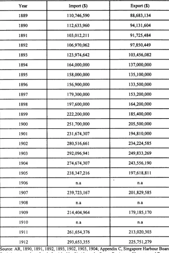
The British regional plan for Southeast Asia was to make the port of Singapore its main entrepot that linked the ports of mainland China with those of the Indian subcontinent. The other ports on the Malay peninsula served as feeder ports to the grand design. Table I illustrates the changing pattern of world trade. A brief glance at the table will establish that the value of imports and exports ofthe port of Singapore increased two and a half times in the period 1889-1912. It is significant to note that the two major imports brought into Singapore for the use of ships docking at the port were coal and oil. The port of Singapore had anticipated the changing technology in shipping and created facilities for the storage of these commodities. Steamships driven by coal and later oil carried trade between Asia and Europe. The other significant bulk cargo that were carried by steamers to European markets were smelted tin and liquid latex.
Table l: Singapore - Import and Export" 1889-1912
Year Import ($) Export ($)
l 8 8 9 I10,746,590 8 8 , 6 E 3 , 1 3 4
I 890 112,633,960 94,131,604
l 8 9 l 103,012,211 91,725,484
t892 106,970,062 97,850,U9
l 893 123,974,642 103,456,082
r 894 164,000,000 137,000,000
I 895 158,000,000 135,100,000
I 896 156,900,000 133,500,000
1897 179,300,000 153,200,000
I 8 9 8 197,600,000 164,200,000
I 899 222,200,000 185,400,000
1900 251,700,000 205,500,000
l 9 0 l 231,674,107 194,810,000
t902 2 8 0 , 5 1 6 , 6 6 1 234,224,585
l 903 292,096,941 249,833,269
1904 274,674,307 243,556,190
1 9 0 5 238,347,216 1 9 7 , 6 1 8 , 8 1 I
l 906 n . a n . a
t907 239,723,167 2 0 1 , 8 2 9 , 5 8 5
1 9 0 8 n . a n . a
I 909 214,404,964 1 7 9 , 1 8 5 , 1 7 0
l 9 l 0 n . a n . a
l 9 l I 261,654,376 2 1 3 , 0 2 0 , 3 0 3
t9t2 293,653,355 225,751,279
Source: AR, 1890, 1891, 1892,1893, 1902,1903,1904;AppendixC,SingaporeHarbourBoard, Statistics as to value of trade furnished by Sir Alexander Stuart, Registrar of Imports and Exports
Hanizah Idris - The Maritime Nexus 68
coal in shipping technology made the port authorities build coaling depots on the offshore islands to facilitate steam-driven ships to load coal for their onward passages. A similar development occurred in 1892 when an oil depot was built at Pulau Bukum when oil was used to propel steamships.s Coal and oil were brought from various sources around the globe to serve the shipping needs of the port of Singapore. The carriers of these heavy bulk cargo needed much deeper port than that offered at the old Singapore river port. Elaborate plans were made and executed to deepen the New Harbour and Tanjong Pagar harbour. The natural shallow harbours were extensively dredged and designed to cater for the change in shipping technologies and the carrying trade.6 It included the dredging of two shoals - the Meander and Tembaga Shoals - that blocked the passages into the New Harbour.T At Teluk Ayer the British authorities invested in reclaiming the offshore area to extend the waterfront from the Tanjong Pagar Police Station to the Gelang River. The inner harbour area under the Telok Ayer reclaimation scheme extended the harbour facilities of Singapore by
" further 1,300 acresE (See Maps). Within these designed harbours there were also investments in other port facilities. The building of dry docks, wharves and jetties created the main fixtures of the port of Singapore. There developed the Empire Dock, Victoria Dock, Albert Dock, East Dock and West Dock.e These were owned and operated by the private shipping concerns who were the captains of the industry.
Table 2: Singapore - Revenue and Expenditure, 1905-1912
Year Revenue ($) Expenditure ($)
I 9 0 5 5 .240 .3 54 .26 4,072,004.79
I 906 5 , 6 1 7 , 7 8 4 . 9 2 4,097,428.62
r901
6 , 1 5 4 , 5 7 9 . 2 5 ' 4 . 4 8 4 , 4 7 6 . 2 0 I 9 0 8 5,822,81 I .69 4 , 2 7 1 , 7 1 5 . 3 7r 909
5 , 8 4 9 , 0 6 3 . 0 0 4 , 2 7 1 , 7 1 5 . 2 7l 9 l 0 5 , 8 9 6 , 1 5 6 . 5 2 4,328,184.47
l 9 l I 5.140.965.09 4,074,669.33
t9t2
6.0
r 5.648.00
4 . 2 1 6 . 0 1 5 . 0 0S o u r c e : A R , S S , 1 9 0 9 , I 9 l l . 1 9 1 2 .
Map 1:Telok Ayer Reclamation Plan(Proposed Extension)
Source: C.O 273/34:Telok Ayer Reclamation, Sir John Coodc to Colonial Secretary, S.S., dlm SSLCP, 1887, pg.C263
z I
F
E -< 9
J 6
( J -trj ;
, Y X . b g
2 C c
= l r J ;
i'eE
- a = J
u.J
F
\
+
\
!
!
! - !
l ! r
t .
i;!3
i - : ! 3
3 . . 1
!ii!
ljiN
=
a a I I
:a a a a I a !
nI t
l l
t l
Hanizah Idris - The Maritime Nexus 70
Map 2: General Plans Showing Positions & Details of Borings, Dated 31st December 1929
i ) \
IS
: ' - / f i - ' ' i
Source: C.O 2731563: Singapore Harbour Board, Proposed Wharf Extensions, Report by Mr. Coode, Wilson Mitchell & Vaughan Lee with Three Drawings to C.A. No.Fail:72047,31 December 1929.
-/
li,
, \
l . r
'l-I
nl
{ i
8l
frt I F I e l
':l
tir :'l,l i e l l l -"(l
t t
Ftl F l
Map 3: General Plans, Singapore Earbour Board, Proposed Wharf Extensions, Showing The Proposed New Works, Dated 3lst December, 1929
Hanizah ldris - The Maritime Nexus
72
invesfinents in science and technology that brought together other facilities and services that made the port of Singapore the cutting edge in the twentieth century. Britain made the island of Singapore the centre of telegraph, telephone and wireless facilities before the Second World War.ro Britain brought in electricity to the island in 1923 with the establishment of St. James Power Station and 30 years later increased the power capacity of Singapore four-fold by building a new power station at Pasir Panjang.
The expansion of port facilities and services need fresh water supply.rr The Municipality of Singapore successfully negotiated with neighbouring Johor to pipe water across the causeway to be processed in Singapore for its own use. The Municipality guaranteed that processed water will be resold to Johor at pre-agreed prices. The arrival of sailors from all quarters of the world meant that an elaborate service system had to be developed to cater for their needs. One such institution was the Sailor's Home that looked after their temporary accommodation, welfare needs, health care and financial transactions.12 The more spiritual matters were left to the church and the Settlement of Singapore funded church activities to keep the congregation happy.t'
In all instances the port of Singapore managed to keep ahead from the other ports of the Malay peninsula and the rest of the region because it planned and designed its development against world shipping and trade patterns and trends. The other neighbouring islands that were the suppliers of raw produce for Euro-Asian trade and the importers of manufactured goods simply allowed Singapore to go unchallenged. The former invested on infrastructures at the production end (roads, rails, bridges, dams and drains) while Singapore invested at the marketing end on harbours, wharves, dredging, lighthouses, moles, docks, electricity, schools and hospitals. It emerged before the belinning of World War Two as the most technologically advanced island of all of Southeast Asia. It was made the maritime nexus of Southeast Asia.
Notes:
l.See Shaharil Talib,'Singapore (1824-1958): This is My Island in the Sun',,/alr, Bilangan l, Septcmber 1995, Jabatan Pengajian Asia Tenggar4 Universiti Malaya, Kuala Lumpur. 2.Ali Zainalabidin Syed Mohamed, 'Sejarah Pembinaan Tambak Johor', B.A. thesis, Dept. of Southeast Asian Snrrdics, Univenity of Malaya,l992.
3.lchiro Sugimoto,'Pc'rkcmbangan Kapitalisme diNcgeri Johor, 1800-1957', M.A.thesis, Dcpt. of Southeast Asian Studies, University of Malaya which is in the process of completion. 4.Currcnt Rcscarch by M.A. candidate, Yuka, Dept. of Southeast Asian Studies, Univcrsity of Malay4 1995.
6.Scc CO 2731279:Singaporc Harbour Improvcmcnts, Mr. Manhcw Rcports, 5 Fcbruary 1902, t.97-9t.
7.Sce CO 2731563:Singaporc Harbour Board, Proposcd Wharf Extcnsions, Rcport by Mcssrs. Coode, Wilson Mitchell & Vaughan Lcc with thrcc drawings to CA, 3l Dcccmbcr 1929. t.Sec CO 2731279: Mcssrs.Coodc, Son & Matthcws, lftlt Doccmbcr 1901.
9.Scc CO 3731562: Dockyard Dcpartmcnt Thc Singaporc Board, Rcport & Account Endcd for thc Year 30th. Junc 1930, f.9.
l0.Hasliza btc lbratrim,'7lrman Gclap di Singapura, lt62-1953', B.A. thcsig Dcpt. of Soutcast Asian Studies, Univcnity of Mdaya, 1993194.
I l.Ruhana Padzil, 'Bckalan Air di Singapura (lt2+1956): Dari Pcncarian Sumbcr Air kc Sumbcr Pendapatan', B.A. thcsis, Dcpt. of Southcast Asian Studics, Univcrsity Malaya, 1993194. l2.Cunent rcscarch by B.A. candidatc, Shamsidah Hasan, Dcpt. Southeast Asisn Studics, Univcrsity of Malaya.