Abstract—As the container traffic of the world is steadily increasing, the space of logistics warehouse that handles the traffic is expanding. To reduce time and cost needed to find the pallets, it is necessary to know the accurate location of pallets. However, the state-of-the-art techniques of using localization systems exactly cannot recognize its location due to diffraction, absorption and reflection of radio signals in the warehouse. We propose three methods for exactly and quickly identifying location of pallets inside logistics warehouse. The first proposal is to attach RFID(Radio Frequency Identification) tags at the ceiling of warehouse. The second proposal is OSLE(Onion Skin Location Estimation) algorithm to find location by that environment. The final proposal is OAD(Orthogonal Antenna Direction) algorithm to improved the accuracy result of OSLE algorithm. Through performance evaluation, it is concluded that the distance between real location and measured location of using OAD is closer than the distance of using OSLE.
IndexTerms—OAD algorithm, OSLE algorithm, RFID tag.
I. INTRODUCTION
The international logistics market of showing 4 trillion dollars scale in one year. It is a higher value-add market that is growing at annual average of 7%. If this trend continues, the market scale is expected to be 8 trillion in 2020. In addition, the container traffic of the world in 2010 was 527 million TEU. It is 10.8% increased from 2009 traffic which is 476 million [1]-[4].
To store and handle heavy container traffic in this situation, owners best solution is to increase space and the number of logistics warehouses. As the volume of warehouse becomes huge, the logistics cost; transporting, storage, searching, etc, also increases. Naturally they focus on reducing the cost.
There are some methods to reduce logistics cost. One is dividing the warehouse into particular districts for loading or unloading pallets conveniently (reduce transport cost). Another method is to construct a complete automation system for the warehouse (reduce personnel expenses). The other method is to find the accurate location of pallets (reduce search cost).
Among them, to find the accurate location of pallets in warehouse is at the top of priority list in this paper because someone such as a manufacturer wants to speedily handle
Manuscript received November 4, 2012; revised January 24, 2013. Seungwoo Jeon and Bonghee Hong are with the Department of Computer Engineering, Pusan National University, Busan, Republic of Korea (e-mail: [email protected], [email protected]).
Mikyung Choi is with Telecom & Convergence Business Group, KT, Seoul, Republic of Korea (e-mail: [email protected]).
Joonho Kwon is with the Institute of Logistics Information Technology, Pusan National University, Busan, Republic of Korea (e-mail: [email protected]).
demands about its storing and releasing. For example, when users request the releasing of some pallets, the systems have to find and release the pallets immediately.
GPS (Global Positioning System) and RTLS (Real-Time Locating System) is state-of-the-art technologies for tracing location of someone or something. However, these technologies cannot be applied to the warehouse due to some problems. In the GPS case, the receiver cannot receive signal from satellite due to the wall. In the RTLS case, if there is an obstacle between the reader and the tag, errors occurred or the location cannot be measured due to diffraction, absorption and reflection in the worst case.
In this paper, we propose three methods for overcoming the problem which the existing technologies have. The first proposal is to attach RFID (Radio-Frequency identification) tags at the ceiling of warehouse in other to reduce disruption of transmitting radio signals. The second proposal is OSLE (Onion Skin Location Estimation) algorithm to identify pallets location based on acquired RFID tag data. Finally we propose OAD (Orthogonal Antenna Direction) algorithm to fix the error of OSLE algorithm proposed. Through the experiments, we have proved that the result of using OAD algorithm and OSLE algorithm is better than the result of using OSLE algorithm only.
The remainder of this paper is organized as follows. Section II contains the related works, RFID and state-of-the-art technologies. Section III defines the target environment and problem which existing technologies have. In Section IV, we explain the proposed three methods to solve the problems. Section V presents experimental results of performance evaluation. The paper conclusion is presented in Section VI.
II. RELATED WORK A. RFID Technology
RFID is a technology that uses radio waves to transfer data from an RFID tag attached to an object to a reader for the purpose of identifying and tracking the object [5]-[7]. In comparison with a bar code, both bar code and RFID recognize the object using contactless method. However, bar code can only be read within short distance less than 1-meter, whereas RFID tags can be read from several meters away. RFID technology is consists of four parts: RFID tag, antenna, RFID reader, RFID middleware system and has five processing steps.
P1: Attach tag After writing the information into the RFID tag, attach the tag to object.
P2: Transmit radio signals of antenna When the objects enter a certain area such as gate, the antenna transmits the reader signals to the tags of object.
In-Door Localization Using Orthogonal Antenna Direction
P3: Receive reflected signals of tag The tags information received from the antenna create a reflected signals, contains the information, back to the antenna.
P4: Transmit information The information which antenna received is modulated and transmitted to RFID reader. P5: Store and manage information The reader transmits
the information to middleware which stores and manage the information.
B. Location-Tracking Technology
LBS (Location Based Service) is getting the spotlight in the field of mobile telecommunication because of opening GPS technology for free and supporting policy about the technology in various countries of the world. The current trend is towards expanding from various kinds of in-depth life service such as vehicle tracing, navigation to public service like disaster relief and, emergency services. These services need the acquisition of location information and various studies for obtaining the accurate information are proceeding actively. Among them, the most common ways are to use GPS and RTLS. GPS calculates the time of receiving satellite signals between the satellite and GPS receiver, and then calculates the current location of someone or something [8]. RTLS traces the location of goods in real time [9]. And the location measurement is calculated by triangulation, TDoA (Time Difference of Alive) that calculates the time difference of the arrival of signals among receivers of base stations is the most common measurement techniques [10]-[12].
III. TARGET ENVIRONMENT AND PROBLEM DEFINITION A. Target Environment
The target environment is a logistics warehouse based on RFID techniques. The logistics warehouse consists of two parts: basic components for the warehouse (objects, pallets, shelves, and forklift) and additional components for RFID techniques (RFID tags, antenna, RFID readers, and processing system).
If the basic action principles of the warehouse combine with RFID action principles, we get the following scenario. S1: Stock pallets The pallets which attach tags are stocked
by forklift in the warehouse.
S2: Transmit/Receive radio signals of antenna When the forklift enters in the warehouse, the gates antenna transmits the signals to the pallets tag and the tags create a reflected signal. Finally, the signals sent to antenna. S3: Recognize pallets and Check condition The
middleware recognizes the fact that the pallets are stocked through the information received from the antenna.
S4: Store pallets The forklift puts down the pallets on the warehouse shelves.
S5: Move pallets The forklift moves the pallets to any location for releasing the pallets.
S6: Transmit/Receive radio signals of antenna It is the same action principle of S2.
S7: Recognize pallets and Check condition It is the same action principle of S3, but this step is the release. S8: Release pallets The pallets are released by forklift out
of the warehouse.
B. Problem Definition
The important issue in this paper is to find the accurate location of pallets in the logistics warehouse. However, in spite of being the state-of-the-art techniques, it is not possible to find the accurate location [10]-[15].
In GPS, there is a problem that if there is someone or something in any place (indoor, tunnel, and basement) that cannot receive satellite signals, the technique cannot be used. Also, if the signal hits an obstacle, signal strength may be lost through reflection, diffraction, and absorption.
In RTLS, this system decides the location through information received from three base stations. However, if DOP (Dilution of Precision) according to the location between the base stations rating is poor, the location accuracy falls sharply [11], [14]. And if the signals received from base stations in the warehouse are lost, the location accuracy also falls [15].
When the tag makes an acute angle (0˚ <α<90˚ ) with the reader, a horizontal distance between the tag and the reader becomes longer. It caused the reader signals frequently hit an obstacle in the warehouse, finally the signals are attenuated.
IV. METHODS FOR TRACING LOCATION
In this paper, we propose three methods as a workable technique for identifying an accurate location of pallets in logistics warehouse.
A. Adapting RFID Technology as LBS
Fig. 1. Environment combined the RFID technology with a logistics warehouse.
Because this composition makes a horizontal distance to zero and angle to 90 degrees between the antenna and the tag, the loss of the signals can be reduced. Also, because the price of RFID tag cost is not so much as RTLS tag, to establish RFID environments is far better than RTLS in cost aspect of equipment.
to find the accurate location of pallets from the acquired data. B.
When the forklift with antenna is loading pallets into the warehouse, the antenna detects some tags which are attached to ceiling and transmits the information of detected tag to the middleware. And the middleware finds the accurate location of pallets. Current middleware is using the OSLE algorithm. The algorithm consists of three steps.
OSLE1 Distinguish outlier to find outliers that have a bad influence upon the identification of location. 1) Calculate the center of tag, denote by C where x and y is
the coordinate, sets detected by antenna among tags attached to ceiling.
n y t n x t n y x t y x C n t i n t i nt 1i 1 1 ( )
, ) ( ) , ( ) ,
( 1
2) Calculate the distance d between the center of tag sets calculated to (1) and each tag.
1
2 2 2
( , )
( , )
((
)
(
) )
i i i i i i
d
C x y
t x y
x
x
y
y
23) Calculate the pair p about each tag and the distance of (2).
)
1
(
),
,
(
t
d
i
n
p
i
i i
3
4) For making a concentric circle of onion skin, pick out
q
i, set which has elements as set ofp
i.)
1
(
},
1
|
{
p
k
d
k
k
l
q
k
i
i
45) Calculate the center of
q
k.
1 1 1 1)
(
k l k k k l k k kq
n
q
CQ
6) Calculate
S
k , the difference betweenCQ
k and1
k
CQ
.
1 1 1 1 1 1 1 1 1 ) ( )( l k
k k k l k k k l k k k l k k k k k q n q q n q CQ CQ
S
7) Decide outlier. If the value of outlier is less than or equal to 0 then
l iz
io
1 If the value of outlier is greater than 0, then
1 1l i
z
io
OSLE2 Remove outlier to remove outliers in the all tag sets.
o
t
r
OSLE3 Identify location to identify the location through calculating the center of tag sets, denotes by CR, that outliers are removed.
) ( ) ( , ) ( ) ( ) ( ) , ( ) ,( 1 1 1
r n y r r n x r r n y x r y x CR n i i n i i n
i i
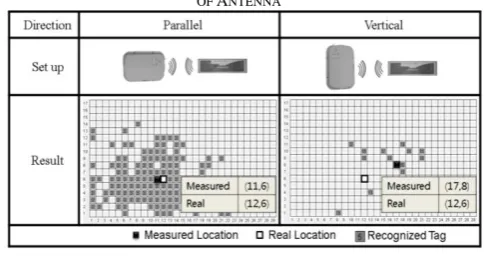
Table I shows the results of preliminary experiments applied to OSLE algorithm according to direction of antenna. When the antenna and the tag are parallel, the number of recognized tags is more than another case. Because of this, the algorithm can easily remove outliers and we get more accurate location.
From this result, we deduct that maintain parallel position between antenna direction and tag is important. Since the forklift cannot maintain the direction, more efficient algorithm is required to solve this problem. This algorithm will be presented in the next subsection.
TABLEI:RESULTS OF USING OSLEALGORITHM ACCORDING TO DIRECTION OF ANTENNA
C. Orthogonal Antenna Direction Algorithm
To solve forklift direction problem, we use two methods: a supplementation about environment settings and an improved algorithm for the supplementation.
Install Vertical-Horizontal antenna To gain an accurate location at all directions, we propose to install two antennas in orthogonal direction. This method has a role reducing a scope of errors regardless of forklift direction.
Orthogonal Antenna Direction Algorithm If the tag data acquired from two antennas apply to each OSLE algorithms and combined the result, it can gain more accurate result than using only one OSLE algorithm. The most important thing is how to combine each result of OSLE algorithm because if each result is just combined to the average, the accuracy cannot be improved. Therefore, we propose OAD algorithm that gives weighted values to each result. OAD algorithm consists of three steps.
OAD1The sum of tag data recognizedCalculate the sum of tag data recognized to each antenna.
2 1 TagCount
TagCount
Sum
OAD2Apply weighted value Multiply the counts of tag data by the values of x and y using OSLE algorithm and ad d the results multiplied.
) (
)
(x1 TagCount1 x2 TagCount2
WVx
) (
)
(y1 TagCount1 y2 TagCount2
WVy
OAD3Calculate weighted averageCalculate a weighted ave rage based on (11) ~ (13).
) (
) (
) (
2 1
2 2
1 1
TagCount TagCount
TagCount x
TagCount x
Sum WV
WA x
x
) (
) (
) (
2 1
2 2
1 1
TagCount TagCount
TagCount y
TagCount y
Sum WV
WAy y
The Table II shows the results of OAD algorithm. Firstly, one antenna is installed to vertical direction; another is installed to parallel direction. Compared with Table I, all of the conditions except the number of antenna are the same. And through preliminary experiments, we were able to confirm that OAD algorithm compensates (11, 6) as the measured result in the parallel antenna to (12, 6) by using the measured result in the vertical antenna.
TABLEII:RESULTS OF USING OADALGORITHM
V. EXPERIMENTAL EVALUATION A. Experimental Environment
Fig. 2. Tag layout attached at the ceiling.
According to a situation, one or two antennas are installed to the upper part of the forklift. If two antennas are installed to the forklift, the antennas have to be installed in orthogonal direction.
B. Performance Test according to Direction of Antenna and Tag
As explained in Table I, the number of recognized tags according to direction of antenna is different. If the number is too few, outliers of (7) or (8) are hard to find and eventually real location cannot be found.
Fig. 3 shows errors according to direction of antenna and attenuation. The errors mean the distance between real location and measured location, and the attenuation means signal strength of antenna. When the direction of a tag and an antenna is parallel, the location error is about 30~80 cm less than vertical case regardless of attenuation. Nevertheless, if someone finds a compact pallet of smaller than 25cm, they can get another near the wanted pallets.
Fig. 3. Results of OSLE algorithm performance test according to direction and attenuation.
C. Performance Test according to Applying OAD Algorithm
We found that the measured errors are big through OSLE algorithm performance test. New test applies to OAD algorithm using two antennas for reducing the range of errors.
Fig. 4 shows the results of comparing OSLE algorithm with OAD algorithm. Through these results, we have confirmed that one antenna helps to compensate the measured result of another antenna. Therefore, if a user applies the OAD algorithm to finds the pallet location, the user can be sure to gain more accurate results.
Fig. 4. Results of OAD algorithm performance test.
VI. CONCLUSION
The international logistics market was increasing steadily and these trends are expected to continue. In addition, as container traffic is increasing, the owners also increase warehouse space to handle it. More container in a bigger warehouse space means increase cost. More containers in a bigger warehouse mean increase of cost for searching the The experimental environment for performance
wanted container. Among some solutions to reduce the cost, we focus on finding the accurate location of pallets. There are several existing technologies such as GPS and RTLS to trace objects location. However, these technologies cannot be used because the equipment cannot receive radio signals in the warehouse due to diffraction, absorption and reflection.
In this paper, we propose three methods to solve this problem: To attach RFID tags at the ceiling of warehouse based on RFID technology, OSLE algorithm to identify location of forklift, OAD algorithm to make up for fault of OSLE algorithm. And through the experiments, we have proved that the result of using OAD algorithm is better than the other.
ACKNOWLEDGMENT
This work was supported by the National Research Foundation of Korea(NRF) grant funded by the Korea government(MEST) (No. 2012R1A2A2A01014046).
REFERENCES
[1] Economist Intelligent Unit, Market indicators & forecast, 2011.
[2] Drewry, Container market review and forecast, 2010.
[3] Global insight, World economy service, 2010.
[4] International Monetary Fund, World economic outlook database,
2010.
[5] RFID. [Online]. Available:
http://www.en.wikipedia.org/wiki/Radio-frequency_identification. [6] I. H. Nam, RFID Outline and Application, 2005.
[7] K. B. Lim, H. Y. Kim, and D. H. Rie, “The research of the analysis of movement from a fire using RTLS system,” J. of Korean Institute of Fire Sci. & Eng, vol. 24, no. 4, pp. 98-103, 2010.
[8] GPS. [Online]. Available: http://www.en.wikipedia.org/wiki/Gps.
[9] RTLS. [Online]. Available:
http://www.en.wikipedia.org/wiki/Real-time_locating_system. [10] K. M. Yeo and J. H. Ahn, Location based service technologies and
standards, electronics and telecommunication trends, vol. 24, no. 6, 2010.
[11] K. H. Oh, “An active location-detecting system for a location based service,” Master's Degree Paper, 2009.
[12] H. Choi, D. H. Ji, and Y. J. Back, “Improvement of TDOA-based localization method for port logistics environment,” KICS, vol. 34, no. 2B, pp.99-106, 2009.
[13] Y. J. Kim, “A basic experimental study on location system of ubiquitous& LBS surveying concepts,” Master's Degree Paper, 2011. [14] R. B. Langley, “Dilution of precision,” GPS World, pp. 52-59, 1999. [15] D. G. Jung, W. S. Ryu, J. K. Park, and B. H. Hong, “Design and
implementation of location error correction algorithm for RTLS,” in
Proc.2008 Spring Conference of Korea Spatial Information System
Society, pp. 286-292, 2008.
[16] S. W. Jeon, M. K. Choi, G. H. Kim, and B. H. Hong, “Localization of pallets based on passive RFID tags,” in Proc. 7th International
Conference on Information Technology, pp. 834-839, 2010.
Seungwoo Jeon received the MS degrees in Computer
Engineering from Pusan National University, Busan, Korea, in 2011. He is Ph.D Candidate at Pusan National University, Korea. His current research interests include moving object databases, RFID system and RFID/RTLS/Sensor middleware.
Mikyung Choi received the MS degrees in Computer
Engineering from Pusan National University, Busan, Korea, in 2010. She is manger with Telecom & Convergence Business Group, KT company, Seoul, Korea. She has developed RFID middleware with Research Center for Logistics Information Technology. Her current research interests include RFID system.
Bonghee Hong received the MS and PhD degrees in
Computer Engineering from Seoul National University, Seoul, Korea, in 1984 and 1988. In 1987, he joined the faculty of Computer Engineering of the Pusan National University (PNU). He is working as a Professor of Database in the Department of Computer Engineering at the PNU. He is a Director of Institute of Logistics Information Technology. He is also a steering committee member of DASFAA and was a co-chair of APWeb 2010. His research interests include theory of database systems, moving object databases, spatial databases, RFID system and RFID/RTLS/Sensor middleware.
Joonho Kwon received his PhD, MS and BS degrees