R E S E A R C H
Open Access
An open Web-based system for the analysis and
sharing of animal tracking data
Ross G Dwyer
1*, Charles Brooking
2, Wilfred Brimblecombe
2, Hamish A Campbell
1,4, Jane Hunter
2,
Matthew Watts
3and Craig E Franklin
1Abstract
Background:Improvements in telemetry technology are allowing us to monitor animal movements with increasing accuracy, precision and frequency. The increased complexity of the data collections, however, demands additional software and programming skills to process, store and disseminate the datasets. Recent focus on data availability has also heightened the need for sustainable data management solutions to ensure data integrity and provide longer term access. In the last ten years, a number of online facilities have been developed for the archiving, processing and sharing of telemetry data. These facilities offer secure storage, multi-user support and analysis tools and are a step along the way to improving data access, long-term data preservation and science communication. While these software platforms promote data sharing, access to the majority of the data and to the software behind these systems remains restricted. In this paper, we present a comprehensive, highly accessible and fully transparent software facility for animal movement data.
Results:The online system we developed (http://oztrack.org) offers a set of robust, up-to-date and accessible tools for managing, processing, visualising and analysing animal location data and linking these outputs with environmental datasets. As OzTrack uses exclusively free and open-source software, and the source code is available online, the system promotes open access not only to data but also to the tools and software underpinning the system.
Conclusions:We outline the capabilities and limitations of the infrastructure design and discuss the uptake of this platform by the Australasian biotelemetry community. We discuss whether an open approach to analysis tools and software encourages a more open approach to sharing data, information and knowledge. Finally, we discuss why a free and open approach enhances longer term sustainability and enables data storage facilities to evolve in parallel with the telemetry devices themselves.
Keywords:Electronic tagging, Electronic tags, Environmental data, GPS, Information management, Kalman filter, Movement ecology, Open access, OzTrack, PostgreSQL, PostGIS, R, Relational database, Tracking software, VHF, Wildlife monitoring
Background
Animal biotelemetry is a dynamic and rapidly evolving field of ecology. The number of publications featuring the use of telemetric devices to provide fundamental in-sights into a species’ecology has increased steadily over the past 30 years [1,2]. Technological advancement dur-ing this time has improved positional accuracy and is allowing the collection of more frequent location fixes over longer time periods [3,4]. Furthermore, tag size and weight have substantially reduced [5], as has unit cost
[6], broadening the spectrum of species and life stages that can be studied. These developments in tracking technology and data acquisition have reduced the effort required to gather high-quality animal location data, providing researchers with an opportunity to build a co-herent picture of how animals behave within their nat-ural environment.
The relative ease and low cost by which temporally dense sets of animal locations can now be collected is in-creasing the volume of data collected and thus making ef-fective management of the data challenging. Telemetry devices now routinely generate datasets that are larger than off-the-shelf software tools or spreadsheet appli-cations can handle [7,8]. While dedicated, proprietary * Correspondence:[email protected]
1
EcoLab, School of Biological Sciences, The University of Queensland, Brisbane, Australia
Full list of author information is available at the end of the article
software platforms for processing these tracking data are available directly from the tag manufacturers, many large-scale and long-term studies utilise tags sourced from mul-tiple manufacturers (e.g. [9,10]). In this scenario, a number of independent applications may be required; these in-clude software tools designed for spatial data management and visualisation, as well as tools to filter and analyse spa-tiotemporal datasets. Typically, this requires data replica-tion and export/import procedures across multiple software applications, which can be time-consuming and prone to error and duplication [11].
To ensure data persistence and to facilitate comparative studies across species and localities, the secure, consistent and efficient management of data is essential. If raw data are stored locally in personal databases, they are at risk of being lost or discarded due to disk failure or the data owner changing offices or careers. As data are collected as a result of disturbing animals, and many programs are funded by public money, there is a responsibility for the researcher to provide public access to their data once funding and publishing obligations have been met [12,13]. Data publishing is already a high priority in many fields, and many research journals and funding bodies now re-quire that data supporting the results of studies are ar-chived in an appropriate public archive which guarantees their re-use and preservation [14].
While some researchers may be unwilling to transfer their datasets into an online data repository (e.g. for fear of others misusing their data or using it without proper ac-knowledgement [15]), data management and dissemination through the Internet offers some clear advantages. For ex-ample, ongoing telemetric studies may require updating on a regular basis with new data and recent deployments [16], and project collaborators may want to be kept informed on the study’s progress and the current whereabouts of tagged animals. The data may be useful for educational or public outreach purposes, which can increase the profile of the research through mass media and articles in national and international news outlets [17]. Increased data trans-parency may also stimulate collaboration, through the sharing of data between research groups and specialists in the same or related fields. This increased synergy may re-duce the need to collect further or new data and can lead to academic as well as financial gains [14,18]. While a number of groups have succeeded in developing their own infrastructure for this purpose (e.g. Whalenet [19], the Narragansett Bay Coyote Study [20], the Information System for the Analysis and Management of Ungulate Data [21]), developing such infrastructure requires consid-erable time and resources, including collaborative input from information technology (IT) and e-Science experts.
In recognition of these challenges, some wildlife biolo-gists have stressed a need for free online facilities with standardised tools and techniques for telemetry data
[11,17,22]. These facilities should not be limited to data management but should also support the analysis, visualisa-tion and sharing of animal tracking data. A number of Web-based animal telemetry data repositories are currently available for this purpose. These include Movebank [23], OBIS-SEAMAP (Ocean Biogeographic Information System-Spatial Ecological Analysis of Megavertebrate Populations) [24], Wildlife Tracking (formerly Seaturtle.org) [17], Wireless Remote Animal Monitoring [25] and the European Roe Deer project [26]. Data within these repositories are stored in a way which permits multi-user support and data sharing, a secure and consistent storage system and ana-lysis and filtering tools of varying complexity. However, the data policies of these facilities are still restrictive [13], with only a small fraction of contributed datasets access-ible for downloading or viewing. Furthermore, the infra-structure underlying these repositories remains guarded (or focused on a single species), reducing the potential for the examination and further development of these tools by the wider biotelemetry community.
In this paper, we introduce an online platform based on a spatially enabled database management system (DBMS) for the archiving, analysis and dissemination of multi-species tracking data: OzTrack.org [27,28]. Our main objectives were twofold. The first objective was to develop a free, open source, highly accessible yet comprehensive Web-based application with automated procedures and tools for processing animal location data. Our second objective was to increase data and metadata visibility, thereby encour-aging a data sharing culture amongst the animal tracking community. These objectives were achieved through a collaborative partnership between biologists and software engineers based at The University of Queensland, and a steering committee comprising researchers and practi-tioners of wildlife telemetry and eResearch services. Re-searchers conducting biotelemetry studies now have access to the tools and contributed telemetry datasets resulting from this collaboration. Here, we provide a description of the software architecture, discuss system uptake and illus-trate system functionality using existing OzTrack projects. Finally, we discuss future developments and argue why an open-access approach to data, analysis tools and software is fundamental if we are to keep up with the rapid advance-ment of the devices themselves.
Methods
The database management system
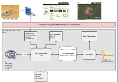
entered via an online form, with animal location data uploaded in Comma-Separated Value (.CSV) or Microsoft Excel (.XLS) files. To increase system flexibility, animal lo-cation datasets may be uploaded with dates and times in the format“dd/mm/yyyy HH:MM” or “yyyy-mm-dd HH: MM:SS”and geographical coordinates as decimal degrees, degrees decimal minutes or degrees minutes seconds in the World Geodetic System (WGS) 1984 datum. The entry of a species’common name and species’scientific name is automated using the Atlas of Living Australia Autocomplete Web service [31]. There is also the option for users to enter the species’common and scientific name manually, increasing the transferability to study outside of Australia. Metadata describing data collections, users and projects within the system are published to Australian Na-tional Data Service-Research Data Australia (ANDS-RDA) in the Registry Interchange Format—Collections and Ser-vices (RIF-CS) metadata format. The OzTrack system is hosted on server infrastructure within the National esearch Collaboration Tools and Resources (NeCTAR) Re-search Cloud. This greatly reduced the administration costs and effort compared with hosting the system locally.
Mapping functionality
underlying code, can be found on the OzTrack GitHub website [33].
Analysis tools
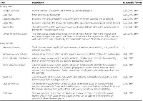
Once location data are uploaded into a project, move-ment metrics such as the total number of fixes per de-ployment, the mean number of fixes per day, animal step length and the minimum distance travelled are ex-tracted automatically using a series of SQL statements. Standard filtering options for data visualisation and ana-lysis were implemented using update statements in SQL, such as setting a start and end date or tag location qual-ity (i.e. Argos location class, dilution of precision class). OzTrack also provides a polygon selection tool per-mitting the user to manually delete improbable location estimates (e.g. an inland location for a marine species) from a project. To perform more complex spatial ana-lyses and data filtering procedures, the system connects to the R programming environment [34] via RServe [35]. Spatial analysis and filtering tools contained within con-tributed R packages (Table 1, Additional file 2: Table S2), and our own customised R code and R-Forge (a R
interface to GDAL, OGR and PROJ.4) are all called in-side the OzTrack system as native procedures (Figure 1). Support regarding the parameterisation of the analysis and filter tools can be found in the form of help icons positioned next to the appropriate tool or through links provided to the R package help files, vignettes and publi-cations via the system’s Web portal [33]. Spatial dis-tances are calculated as great circle disdis-tances on the WGS 1984 ellipsoid, and area calculations are performed after locations are converted from this geographical co-ordinate system into a suitable projected spatial refer-ence system (SRS). SRS conversions are conducted using PROJ.4 projection arguments in the rgdal R package [36], with EPSG codes obtained from spatialreference.org [37]. The results of these procedures (i.e. vector-based objects: points, lines or polygons) are returned to OzTrack using the Keyhole Markup Language (KML) format via RServe for visualisation.
All capture and tagging procedures were carried out with approval from The University of Queensland Animal Ethics Committee (Cassowaries:SIB/935/08/EPA ; Croco-diles: SBS/204/11/ARC/AUST ZOO; Koalas: CMLR/091/
Table 1 Current tool functionality and data formats for export
Tool Description Exportable format
Editing tools
Polygon selection Manual selection of locations for removal by drawing polygons. .CSV, .KML, .SHP
Date filter Filter locations by date range. .CSV, .KML, .SHP
Location class filter Locations with a lower location accuracy than the minimum specified will be deleted. .CSV, .KML, .SHP
Speed filter Locations that imply the animal has exceeded the specified maximum speed will be deleted. .CSV, .KML, .SHP
Kalman filter This filter applies a state-space model combined with a Kalman filter to the location data to predict the“most probable”track.
.CSV, .KML, .SHP
Kalman filtered data (SST) This filter applies a state-space model combined with a Kalman filter to the location and temperature sensor data predict the‘most probable’track. The tag-recorded SST is matched with external SST data collected by the National Oceanic and Atmospheric Administration.
.CSV, .KML, .SHP
Analysis tools
Movement metrics Track distance, mean step length and mean step speed are extracted using the great circle distance algorithm.
-Minimum convex polygon A home range measure which uses the smallest area convex set that contains the location data. .KML, .SHP
Kernel utilisation distribution A home range measure which uses the utilisation distribution to estimate the probability that an animal will be found at a specific geographical location.
.KML, .SHP
Kernel Brownian bridge A home range measure which uses the utilisation distribution to estimate the probability that an animal will be found at a specific geographical location. Unlike the fixed kernel approach, the Kernel Brownian Bridge incorporates serial autocorrelation between fixes into the estimate.
.KML, .SHP
Alpha hull A generalisation of the convex hull, which uses Delaunay triangulation to objectively crop low use areas from a polygon surface.
.KML, .SHP
Local convex hull A home range measure which creates utilisation distributions based on the local nearest-neighbour convex hulls. These are formed by constructing convex hulls around each location in the animal’s trajectory then jointing these hulls together, iteratively, to form isopleths.
.KML, .SHP
Heat map This tool generates a grid over the study area and uses a coloured gradient to visually identify areas of high usage by the tagged animal. Can be applied to either points or connectivity lines between points.
12/ARC/RIO TINTO) and a Queensland Government permits (Cassowaries: DERM 2011/02/01; Crocodiles: WISP05268508; Koalas: WISP05609708).
Results and discussion System uptake
At the time of writing (February 2014), the Web site has recorded 3,298 site visits (comprising 4,603 page views) and 92 registered users (including academics, university students, agency scientists and environmental consul-tants). In total, 1,417 tracks comprising 2,050,812 pos-ition fixes from 55 different species have been uploaded, with location data gathered using telemetric devices (i.e.
Argos, GPS, VHF, light-based geolocations and underwater acoustic), or re-sightings of individually marked animals.
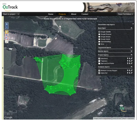
During its development, OzTrack.org was used pro-ductively by a number of research groups and organisa-tions to address a range of wildlife management and conservation scenarios. This included facilitating the visualisation of movements and generating home range estimates for koalas (Phascolarctos cinereus) inhabiting a highly fragmented landscape in South East Queensland, Australia (Figure 2). Here, OzTrack enabled researchers to construct home ranges and identify cleared areas where koalas fitted with GPS collars regularly crossed between habitat fragments. The findings from this study were used to focus habitat restoration activities on
improving connectivity of koala habitat. OzTrack was also employed to monitor the success of a rehabilitation and release scheme for southern cassowaries (Casuarius casuarius) [38]. OzTrack’s configurable permission tool allowed the raw locations, movement metrics and home range estimates generated from GPS-tagged birds to be shared between project collaborators (Figure 3). Those collaborators working in the study area were also able to provide valuable insight into local disturbances that helped explain the timing and locality of observed move-ment behaviours. By facilitating data discussion and multi-user support, OzTrack helped elucidate behaviours which would have otherwise been difficult to interpret. Finally, between September 2013 and February 2014, OzTrack was used as both a research tool and as a
platform to promote public awareness towards estuarine crocodiles (Crocodylus porosus). Large crocodiles pose a significant risk to humans, and there are significant soci-etal and political challenges in managing this potentially dangerous species [39]. To help raise public awareness re-garding the habits of wild estuarine crocodiles, OzTrack was used to archive the movements of six adult crocodiles fitted with GPS transmitters (Figure 4). The project was open to the public to view the tracks in near real-time and apply a selection of analysis tools, and it was promoted via articles in the popular press and through public lectures. Promoting awareness through public outreach is necessary in order to explain science to the public and media; it is also a necessity to endorse fundraising activities, conserva-tion measures and management decisions.
Open tools and software
By running a spatial DBMS within research cloud infra-structure, we achieved a scalable, persistent and secure data storage capability in which large tracking datasets can be managed in a structured and consistent manner [27]. The system is able to visualise tracks and extract move-ment metrics from datasets containing hundreds of thou-sands of animal locations. Dynamic upload capabilities with automated data recognition allow location data to be ingested into the DBMS with minimal pre-processing prior to upload, regardless of origin, time zone or geo-graphical region. Integrating tools for spatial data visual-isation (GeoServer) [32] and analysis (R) [34] combine the data archiving and processing components within a single online software platform [27]. As a result, location data can be edited, filtered, analysed and visualised with
environmental and geopolitical layers without the need to convert and upload data files into separate software appli-cations. This reduces the need for multiple copies of fil-tered and unfilfil-tered datasets in numerous data formats (e. g. .TXT, .CSV and .SHP) and thus the potential for data du-plication and error propagation.
software. First of all, it is cost-effective, an important factor for smaller research bodies, consultancies and conservation organisations who have limited resources to dedicate to-wards software purchasing [40]. Second, the system is ac-cessible from any computer or tablet with a Web browser. This benefits researchers who may work across multiple computers and devices and students or employees who may not have local administrative access on their com-puter. Third, the system provides a real-time collaborative environment where multiple users can access the same project. This is done via configurable permissions and ac-cess rights which are provided by the data owner to other OzTrack users through system’s Web portal (Figure 1, [27]). This combination of free and open tools, infrastruc-ture and a collaborative environment has been highlighted as key requirements to lead to more informed conclusions and management decisions [5,41].
Our trials with tertiary students illustrated the system’s potential for teaching how biotelemetry can be a useful re-search tool in wildlife ecology and conservation. The main advantage over conventional methods was that once in-formed of the underlying theory, users were able to carry out standard procedures for analysing animal telemetry data without any “entrance barriers” [40], such as the requirement for students to be already proficient in a geo-graphical information system (GIS) or have prior experi-ence in using R. Many of the analysis and filtering tools implemented within the OzTrack system were modified from original functions contained within contributed R packages (Additional file 1: Table S1). Rather than R’s command-line interface, the system provides an intuitive user interface that links to these functions though the Web portal. Users can access models, alter parameters, run analyses, visualise results and download data for post-processing without the need to develop or enter R code. Online help documentation and links to relevant publica-tions are provided alongside each analysis or filtering tool as are tips for running models and providing reliable results. By integrating these tools within an accessible Web-based system, users can quickly understand how the choice of filter, model and parameter values influences es-timates of animal movement and space use. Provided there is a thorough understanding of the statistical as-sumptions, we argue that by improving access to current tools in animal movement, research will encourage their uptake by the tracking community (particularly those in-experienced in R), thereby improving the quality and ap-propriateness of the analyses run.
The system’s source code (including the underlying R code) has been released publically [33], providing users worldwide with the opportunity to verify, customise and rebuild the OzTrack system locally. This open approach to software is contrary to the “black-box” approach offered by many existing proprietary platforms, but is the same
model adopted by Tagbase [42], and the R Programing Language [24] which sits at the core of OzTrack’s analysis tools. An open system controlled, developed and managed by the global animal tracking community increases the po-tential for online facilities like OzTrack to evolve in paral-lel with advances in biotelemetry research. This scalability is vital for software long-term persistence, allowing for continual implementation and integration of new and powerful analysis tools, not only by a specific project or institution but also by the global biotelemetry community.
Open data
Registered users of OzTrack are able to create and de-scribe new projects, upload datasets into specific pro-jects, add users to projects and specify access controls and embargo periods. Once raw location data have been uploaded into a project, project owners can choose to embargo their data for a period of up to 3 years. While providing instantaneous access to telemetry datasets can be beneficial, this period was chosen because it provides adequate time for data owners to fulfil funding and pub-lishing obligations before public access is granted. Data are protected under a number of Creative Commons At-tributions Licence agreements, ranging from fully open access with no copyright [43], to strict limitations on usage [44]. Despite the increase in the number of data repositories holding tracking data, the vast majority of projects have not been made publicly available [13]. We consider a fixed embargo period with secure data licenc-ing, and a digital object identifier (DOI) for released tel-emetry datasets, to be the optimum approach to inspire ecologists to move away from a research culture where data is proprietary, while installing measures to protect the intellectual property (IP) of the data owners.
behaviours can vary according to life history or habitat characteristics [9], providing complete and accurate meta-data is critical to ensure that researchers not involved in the data collection process can properly account for accur-acy and precision, detection probability and the species’ ecology. In many cases, the data collected is not only valu-able for the initial study objectives but also valuvalu-able for broader, longitudinal comparisons across studies, species, geographical range and years [47]. International projects such as the Starkey Project [48], OBIS-SEAMAP [24] and the European Roe Deer (EURODEER) project [26] illus-trate the power of taking a collaborative and synthetic ap-proach across species and localities. Furthermore, increased availability of raw data, and the error estimates for each location, also allow for better parameterizing and scrutinizing of Bayesian and mechanistic models (e.g. [49,50]). In these cases, increased sample size enables studies utilising these databases to generate predictive models that are more accurate, more reliable and enable stronger conclusions to be made. However, in order to en-sure long-term accessibility and re-use of telemetry data, there is a need for a consensus with regard to best practise and data format standards between researchers, statisti-cians, tag manufacturers and database developers [15]. Only by creating global standards in data formats and metadata, will it be possible to guarantee compatibility and interoperability between telemetry databases, support-ing truly synthetic and trans-disciplinary research.
Future directions
Testing throughout OzTrack’s development highlighted several key areas of improvement [27]. A frequent sug-gestion from users was the implementation of additional R-based analysis and filtering tools, which have proved in-formative in the interpretation of animal movement data. While many of these tools were outside the initial scope of our project, the modular system design supports rapid de-velopment, implementation and integration within our system architecture [51]. An additional step to further fa-cilitate the development of new tools may be to offer the R source code to users as an optional output, together with the raw and edited data, and model results (e.g. [8]). This increased transparency would also facilitate the de-velopment and implementation of new analysis tools by the wider biotelemetry community.
Another key feature requiring further work is the ability to enrich each location record with the relevant environ-mental and socio-economic information describing an ani-mal’s habitat. The OzTrack system currently holds 21 spatial layers describing climatological, environmental and political information (Additional file 1: Table S1) that with the current version of OzTrack can only be associated with locations on map overlays. Many of these layers are Australian-specific (due to our funding criteria), which
allowed us to be more specific on our supplied environ-mental, climatic and political spatial layers. None of these layers have a temporal component, representing mean-composites of environmental datasets over a particular time period with fixed political boundaries. Furthermore, there is currently no feature to allow users to upload vector- or raster-based spatial objects directly into the system. As animal location data is temporal in nature and animals respond to environmental cues which vary dynamically through time [9], it would be worthwhile incorporating spatial datasets at varying temporal resolutions (e.g. using the MODIS atmosphere, land, cryosphere or ocean data products [52]). OzTrack’s Kalman filter tool (obtained from the ukfsst R package [53]), Movebank’s Environmental-Data Automated Track Annotation (Env-DATA) software [54] and the RNCEP package for R [55] all offer this func-tionality. The system architecture was structured in a way to allow the animal locations to be linked with spatial data-sets at varying temporal resolutions. This new functionality would allow the interactions between animals and their en-vironment to be investigated at a much higher resolution, producing much more meaningful relationships.
Conclusions
New developments in tracking hardware, pressures for open access to data and the need for multidisciplinary col-laborations are accelerating us towards a new age of eco-logical research [11]. The system infrastructure that we developed provides an integrated, online, free and open-source system that facilitates the uploading, editing, ana-lysis, archiving and sharing of animal tracking datasets. The observed uptake by the Australasian biotelemetry community suggests that the system is proving a valuable resource for researchers despite the stipulation that the data must become publicly available once the embargo period has expired. While the OzTrack system is still in its infancy, our intent is that its framework will promote col-laboration, encourage future tool development and help ensure the long-term legacy of animal location datasets. Platform sustainability into the future is however unsub-stantiated, due to the short-term nature of funding cycles. Thus, the involvement of the community in terms of fund-ing and system development, as well as integration of the platform into larger eScience infrastructures, may be re-quired to ensure its longevity.
Availability of supporting data
decisions based on koala movements in http://oztrack.org/ projects/40.
Additional files
Additional file 1: Table S1.Environmental, climatic and political layers currently accessible in OzTrack.
Additional file 2: Table S2.Analysis and filtering tools implemented into the OzTrack system with corresponding R packages.
Abbreviations
ANDS:Australian National Data Service; CSV: Comma-Separated Value; DBMS: Database management system; DOI: Digital object identifier; GIS: Geographical information system; IP: Intellectual property; IT: Information technology; KML: Keyhole Markup Language; NeCTAR: National eResearch Collaboration Tools and Resources; OBIS-SEAMAP: Ocean Biogeographic Information System-Spatial Ecological Analysis of Megavertebrate Populations; PNG: Portable Network Graphics; RIF-CS: Registry Interchange Format— Collections and Services; RDA: Research Data Australia; SQL: Structured Query Language; SRS: Spatial reference system; WGS: World Geodetic System; XLS: Microsoft Excel file.
Competing interests
The OzTrack project was funded by the Australian Government’s National eResearch Collaboration Tools and Resources (NeCTAR) eResearch Tools program and the Australian National Data Service (ANDS) Data Capture Program. RGD was partially funded by an Australian Government Endeavour Research Fellowship.
Authors’contributions
RGD prepared the manuscript, provided the statistical support and developed the underlying R code. CB designed and implemented the spatial database management system, Web Portal, GIS functionality and visualization services. HAC and MW provided the vision and original concept for the OzTrack.org project. All authors contributed to drafting the manuscript. The work was carried out within the laboratories of CEF and JH. All authors read and approved the final manuscript.
Acknowledgements
We would like to thank our Steering Committee (G. Baxter, M. Hindell, T. Patterson, S. Phinn, C. Simpfendorfer, N. Ward and D. Westcott) and members of the ACEAS Working Group forAdvancing the application of animal telemetry data in ecosystem managementfor ideas that were essential in our system development. We thank S. Fitzgibbon, B. Ellis, G. Grecian, M. Amos, G. Taylor, L. Carpenter, E. Best, B. Arthur, The University of Queensland Conservation Biology 2013/14 class and multiple others who helped test the system and provided helpful feedback. We would also like to acknowledge Peggy Newman for her work during our system’s early development. OzTrack was supported through the Australian Government’s National eResearch Collaboration Tools and Resources (NeCTAR) eResearch Tools program and the Australian National Data Service (ANDS) Data Capture program. RGD was the recipient of an Australian Government Endeavour Research Fellowship.
Author details
1EcoLab, School of Biological Sciences, The University of Queensland,
Brisbane, Australia.2The eResearch Lab, School of ITEE, The University of Queensland, Brisbane, Australia.3Environmental Decisions Group, The
University of Queensland, Brisbane, Australia.4Department of Ecosystem
Management, School of Environment and Rural Science, The University of New England, Armidale, NSW, Australia.
Received: 22 May 2014 Accepted: 22 December 2014
References
1. Kenward RE. Historical and practical perspectives. In: Millspaugh JJ, Marzluff JM, editors. Radio tracking and animal populations. CA, USA: Academic Press; 2001. p. 3–12.
2. Tomkiewicz SM, Fuller MR, Kie JG, Bates KK. Global positioning system and associated technologies in animal behaviour and ecological research. Philos Trans R Soc Lond B Biol Sci. 2010;365:2163–76.
3. Eckert SA, Stewart BS. Telemetry and satellite tracking of whale sharks, Rhincodon typus, in the Sea of Cortez, Mexico, and the north Pacific Ocean. Environ Biol Fishes. 2001;60:299–308.
4. Fedak MA, Lovell P, Grant S. Two approaches to compressing and interpreting time-depth information as collected by timed-depth recorders and satellite linked data loggers. Mar Mamm Sci. 2001;17:94–110. 5. Cohn JP. Tracking wildlife. Bioscience. 1999;49:12–7.
6. Ropert-Coudert Y, Wilson RP. Trends and perspectives in animal-attached remote sensing. Front Ecol Environ. 2005;3:437–44.
7. Rutz C, Hays GC. New frontiers in biologging science. Biol Lett. 2009;5:289–92.
8. Campbell HA, Watts ME, Dwyer RG, Franklin CE. V-Track: software for analysing and visualising animal movement from acoustic telemetry detections. Mar Freshw Res. 2012;63:815–20.
9. Block BA, Jonsen ID, Jorgensen SJ, Winship AJ, Shaffer SA, Bograd SJ, et al. Tracking apex marine predator movements in a dynamic ocean. Nature. 2011;475:86–90.
10. Wakefield ED, Bodey TW, Bearhop S, Blackburn J, Colhoun K, Davies R, et al. Space partitioning without territoriality in gannets. Science. 2013;341:68–70. 11. Urbano F, Cagnacci F, Calenge C, Dettki H, Cameron A, Neteler M. Wildlife
tracking data management: a new vision. Philos Trans R Soc Lond B Biol Sci. 2010;365:2177–85.
12. Boyd IL, Kato A, Ropert-Coudert Y. Bio-logging science: sensing beyond the boundaries. Mem Natl Inst Polar Res, Spec Issue. 2004;58:1–14.
13. Zuckerberg B, Huettmann F, Frair J. Proper data management as a scientific foundation for reliable species distribution modeling. In: Drew CA, Wiersma YF, Huettmann F, editors. Predictive species and habitat modelling in landscape ecology. New York, USA: Springer; 2011.
14. Boulton G, Campbell P, Collins B, Elias P, Hall W, Laurie G, et al. Science as an open enterprise. The Royal Society Science Policy Centre report 02/12. The Royal Society: London, UK; 2012.
15. Davidson SC. A bigger picture: data standards, interoperability and data sharing. In Spatial database for GPS wildlife tracking data. Edited by Urbano F, Cagnacci F: Springer International Publishing: Switzerland; 2014: 245–270.
16. Cagnacci F, Boitani L, Powell RA, Boyce MS. Animal ecology meets GPS-based radiotelemetry: a perfect storm of opportunities and challenges. Philos Trans R Soc Lond B Biol Sci. 2010;365:2157–62.
17. Coyne MS, Godley BJ. Satellite tracking and analysis tool (STAT): an integrated system for archiving, analyzing and mapping animal tracking data. Mar Ecol Prog Ser. 2005;301:1–7.
18. Huettmann F. Databases and science-based management in the context of wildlife and habitat: toward a certified ISO standard for objective decision-making for the global community by using the internet. J Wildl Manag. 2005;69:466–72.
19. Whalenet [http://whale.wheelock.edu/Welcome.html]
20. Narragansett Bay Coyote Study [http://www.theconservationagency.org/ coyote.htm]
21. Cagnacci F, Urbano F. Managing wildlife: a spatial information system for GPS collars data. Environ Model Software. 2008;23:957–9.
22. Hartog JR, Patterson TA, Hartmann K, Jumppanen P, Cooper S, Bradford R. Developing integrated database systems for the management of electronic tagging data. In Tagging and tracking of marine animals with electronic devices. Volume 9. Edited by J. L. Nielsen, H. Arrizabalaga, N. Fragoso, A. Hobday, Lutcavage M, Sibert J: Springer: Netherlands; 2009: 367–380: Reviews: Methods and Technologies in Fish Biology and Fisheries. 23. Kranstauber B, Cameron A, Weinzerl R, Fountain T, Tilak S, Wikelski M, et al. The
Movebank data model for animal tracking. Environ Model Software. 2011;26:834–5. 24. Halpin PN, Read AJ, Fujioka E, Best BD, Donnelly B, Hazen LJ, et al.
OBIS-SEAMAP: the world data center for marine mammal, sea bird and sea turtle distributions. Oceanography. 2009;22:104–15.
25. Wireless Remote Animal Monitoring (WRAM) [http://www.slu.se/WRAM/] 26. Cagnacci F, Focardi S, Hewison AJM, Morellet N, Heurich M, Stache A, et al.
28. OzTrack [http://oztrack.org/]
29. PostgreSQL: The PostgreSQL Global Development Group. 2006. http://www.postgresql.org/.
30. PostGIS: Refractions Research Inc.; 2007. http://postgis.refractions.net/. 31. The Atlas of Living Australia (ALA) Autocomplete Web service
[http://api.ala.org.au/] 32. GeoServer [http://geoserver.org/]
33. OzTrack GitHub Website [https://github.com/uq-eresearch/oztrack] 34. R Development Core Team: R: a language and environment for statistical
computing. R Foundation for Statistical Computing 2010. http://www.R-project.org. 35. Urbanek S. Rserve—a fast way to provide R functionality to applications.
In Proceedings of the 3rd International Workshop on Distributed Statistical Computing; Vienna, Austria. Edited by Hornik K, Leisch F, Zeileis A. 2003 36. Keitt TH, Bivand R, Pebesma E, Rowlingson B. rgdal: bindings for the
geospatial data abstraction library. R Package Version 0.7-8. 2012. http://CRAN.R-project.org/package=rgdal.
37. Spatialreference.org [http://spatialreference.org]
38. Campbell HA, Dwyer RG, Sullivan S, Mead D, Lauridsen G: Chemical immobilization and satellite tagging of free-living southern cassowaries Aust Vet J In Press.
39. Campbell HA, Dwyer RG, Irwin TR, Franklin CE. Home range utilisation and long-range movement of estuarine crocodiles during the breeding and nesting season. PLoS One. 2013;8:e62127.
40. Tufto J, Cavallini P. Should wildlife biologists use free software? Wildl Biol. 2005;11:67–76.
41. Dettki H, Ericsson G, Edenius L. Real-time moose tracking: an internet based mapping application using GPS/GSM-collars. Alces. 2004;40:13–21. 42. Lam CH, Tsontos VM. Integrated management and visualisation of
electronic tag data with Tagbase. PLoS One. 2011;6:e21810.
43. Creative Commons Attribution—Non-Commercial—No Derivatives License [http://creativecommons.org/licenses/by-nc-nd/3.0/]
44. Creative Commons Public Domain Mark [http://creativecommons.org/ publicdomain/mark/1.0/]
45. Australian National Data Service (ANDS) Research Data Australia (RDA) Portal [http://researchdata.ands.org.au/]
46. Friar JL, Fieberg J, Hebblewhite M, Cagnacci F, DeCesare NJ, Pedrotti L. Resolving issues of imprecise and habitat-biased locations in ecological analyses using GPS telemetry data. Phil Trans R Soc B Biol Sci. 2010;365:2187–200.
47. Nathan R, Getz WM, Revilla E, Holyoak M, Kadmon R, Saltz D, et al. A movement ecology paradigm for unifying organismal movement research. Proc Natl Acad Sci. 2008;105:19052–9.
48. The Starkey Project [http://www.fs.fed.us/pnw/starkey/]
49. Morales JM, Moorcroft PR, Matthiopoulos J, Frair JL, Kie JG, Powell RA, et al. Building the bridge between animal movement and population dynamics. Philos Trans R Soc Lond B Biol Sci. 2010;365:2289–301.
50. Smouse PE, Focardi S, Moorcroft PR, Kie JG, Forester JD, Morales JM. Stochastic modelling of animal movement. Philos Trans R Soc Lond B Biol Sci. 2010;365:2201–11.
51. van Moorter B. From data management to advanced analytical approaches. In Spatial Database for GPS Wildlife Tracking data Edited by Urbano F, Cagnacci F: Springer International Publishing: Switzerland; 2014: 181–212. 52. MODIS Web [http://modis.gsfc.nasa.gov/]
53. Lam CH, Nielsen A, Sibert JR. Improving light and temperature based geolocation by unscented Kalman filtering. Fish Res. 2008;91:15–25. 54. Dodge S, Bohrer G, Weinzierl R, Davidson S, Kays R, Douglas D, et al. The
environmental-data automated track annotation (Env-DATA) system: linking animal tracks with environmental data. Mov Ecol. 2013;1:3.
55. Kemp M, van Loon E, Shamoun-Baranes J, Bouten W. RNCEP: global weather
and climate data at your fingertips. Meth Ecol Evol. 2012;3:65–70. Submit your next manuscript to BioMed Central
and take full advantage of:
• Convenient online submission
• Thorough peer review
• No space constraints or color figure charges
• Immediate publication on acceptance
• Inclusion in PubMed, CAS, Scopus and Google Scholar
• Research which is freely available for redistribution