TOWARDS AN INTEGRATED APPROACH TO THE PLANNING AND MANAGEMENT OF COASTAL ENVIRONMENTS
Sarah Elizabeth Heiiier
M.PHIL TOWN PLANNING
ProQuest Number: 10045999
All rights reserved
INFO RM A TIO N TO ALL U SER S
The quality of this reproduction is dependent upon the quality of the copy submitted. In the unlikely event that the author did not send a complete manuscript
and there are missing pages, these will be noted. Also, if material had to be removed, a note will indicate the deletion.
uest.
ProQuest 10045999
Published by ProQuest LLC(2016). Copyright of the Dissertation is held by the Author. All rights reserved.
This work is protected against unauthorized copying under Title 17, United States Code. Microform Edition © ProQuest LLC.
ProQuest LLC
789 East Eisenhower Parkway P.O. Box 1346
ABSTRACT
The prospects for world population growth are presented. The importance of the world's coastal zone as a provider of the multitude of varying human needs is stressed. The global implications of a substantially larger population continuing to consume the resources of the coastal zone at today’s rate are then considered. The requirement to maintain biological diversity and to plan for the needs of future generations is recognised. Coastal management in its widest sense is necessary on a global scale as a mechanism to balance conflicting uses and ensure an equitable allocation of scarce resources.
Within this wider context, the circumstances surrounding the planning and management of the coastal zone in the United Kingdom are considered. The procedures for planning the coastline, as presently undertaken by Local Planning Authorities throughout the country, cannot be viewed in isolation. They are linked to the administration and management of the many activities and uses of the coastal zone. The nature of these systems is analysed and the unique physical characteristics of the coastal zone considered. The extent and implications of the demands on coastal resources from a number of competing activities are then outlined.
CONTENTS
PAGE. CHAPTER ONE : INTRODUCTION & OVERVIEW
1.1. The global context 7
1.2. The world’s coastal zone 9
1.3. The Coastline of the United Kingdom 14
1.4 The specific problem 18
1.5. Approach of the thesis 19
1.6. Summary 20
CHAPTER TWO : THE PROBLEM IN CONTEXT
2.1. Introduction 21
2.2. Historical background 21
2.3. Current legislation 25
2.4. Government policy 26
CHAPTER THREE : ADMINISTRATIVE AND ORGANISATIONAL FRAMEWORK
3.1. Introduction 39
3.2. Organisations with planning emphasis 40
3.3. Protection of wildlife, landscape and habitat 42
3.4. Recreation 49
3.5. Pollution / water quality 50
3.6. Coast protection / sea defence 51
3.7. Physical operations 54
3.8. Summary 55
CHAPTER FOUR : COASTAL ZONE MANAGEMENT
4.1. History & development of Coastal Zone Management 58
4.2. International position 58
4.3. EEC and Coastal Zone Management 61
4.4. National initiatives 62
4.5. The United States 66
4.6. The Netherlands 69
4.7. France 70
4.8. Australia 71
4.9. New Zealand 72
4.11 Israel 73
4.12. Summary 73
CHAPTER FIVE : COASTAL ZONE MANAGEMENT IN THE UNITED KINGDOM
5.1. Coastal planning and management defined 75
5.2. Previous research into Coastal Zone Management 78
5.3. Summary of position 86
5.4. Policy update 87
5.5. Summary 94
CHAPTER SIX : CONCLUSION
6.1. Introduction 95
6.2. The coastal zone 96
6.3. Management needs 98
6.4. Failures of the present system 99
6.5. Requirements 100
PAGE
APPENDICES
APPENDIX A : Legislation And Guidance Relevant To Coastal
Zone Planning And Management 103
APPENDIX B : (1) Central Government Departments, Agencies and Statutory Bodies specifically Concerned With Various Uses of
The Marine Environment. 108
(2) Central Government Departments, Agencies and Statutory
lOBodies With Responsibilities and Interests in The Coastal Zone.
APPENDIX 0 : Examples of Voluntary and Other Groups with an Interest
in the Activities Taking Place in the Coastal Zone. 115
APPENDIX D ; Definitions of the Coastal Zone and Coastal
Zone Management. 117
APPENDIX E : Key Dates For Coastal Planning 120
APPENDIX F : Proposed Government Action 124
APPENDIX G : Examples of Initiatives in Coastal Planning and
Progress With Coastal Management Plans 126
CHAPTER ONE :. INTRODUCTION & OVERVIEW
1.1 THE GLOBAL CONTEXT
"The average European leaves, at the end of a lifetime, a monument of waste almost 1000
times their bodyweight. The average North American’s waste mausoieum is 3900 times their
bodyweight."
"A survey of sea-floor sediment off the coast of the United Kingdom found an average of 2000
pieces of piastic debris per square metre."
"Over their lifetime each person in Western Countries emits a baiioon of carbon dioxide in which
the carbon aione is 3500 times their bodyweight."
"Over the 1973-87 period, hailed for its growing ’energy efficiency’, worid energy use grew by
20 per cent. Gains in car fuei efficiency between 1973 and 1988 were wiped out twice over by
the rise in car numbers."
"By the year 2100 the worid popuiation is expected to number 11.5 biiiion - an extra world, plus
another China on top of today’s."
"A world of 11.5 billion people would need roughly an extra 12.6 million square kilometres of
land for farms, towns and roads. This amounts to almost a third of today’s worid forest area -
and doubie the worid’s protected naturai areas."
"The ocean is our garden pond: the annuai fish catch already exceeds the sustainable yield of
the world’s seas."
"In the first five decades of the twentieth century, one bird or mammal species was becoming
extinct every 1.1 years - 230 times faster than the pre-human rate. One mammal species in
every fifty has become extinct in the past 400 years."
"Every year an area of tropical forest the size of two-thirds of the United Kingdom is cieared.
Every ten weeks a Netheriands. Every day a Barbados."
1.1.1. The quotations on the preceding page provide a gloomy picture. The world’s population
continues to escalate at an astounding rate. The demands of this growing population result in
the increasing consumption of non-renewable resources and the consequent destruction of the
planet. The serious implications of this mismatch between demand and supply have become
more apparent and, over the last few decades, the focus of attention has increasingly been
directed towards the problems occurring in the area of the world’s surface which forms the
interface between land and sea, the coastal zone. As we shall see, a number of factors have
combined in recent years to focus attention in many countries throughout the world on the
particular issues and conflicts arising in this locality.
1.1.2. On a global scale, an examination of human history shows how growth rates have risen.
Thousands of years ago the growth of the species was curtailed by naturai phenomenon such
as disease, injury, predators, warfare and the availability of food. It is possible to divide world
population growth into five distinct phases (Harrison,1992). The first two of these were
characterised by additions of 63,000 and 677,000 people per year respectively. The third phase
spans the years 1700 to 1950 where, spurred on by the Industrial Revolution, this figure rose
to annual additions of 7,624,000 people. The fourth phase experienced growth of an hitherto
unprecedented level, due to a combination of two factors in particular. The first was the gradual
introduction of modern preventive and curative medicine, including immunisation, improved
water, sanitisation and antibiotics. The second was the agricultural revolution brought about by
the development and use of chemical fertilisers, irrigation and improved seeds. During this
phase, in the 1960’s, the annual growth rate reached its highest level ever of 2.05 per cent. An
average year during this period resulted in an extra 64 million people to feed. The third billion
in total came about in 1960, thirty years after the second, whilst the fourth took only fourteen
more years.
1.1.3.1980 marked the beginning of the fifth phase. The growth rate had slowed slightly to 1.74
per cent per year but, since the starting figure was higher, so were the numbers added each
year. Consequently the fifth billion took just thirteen years and was passed in 1987. It appears
have been added to the total by the end of this decade which is the equivalent of the popuiation
of the whole worid around 1810 (U.N. Dept of Economic and Social Affairs, 1990). if these
figures are correct, the growth of popuiation expected in the 1990’s will result in "two whole
Europe’s, East and West, added in just ten years. An extra United States every two and a half
years. Two United Kingdoms every fourteen months. A Sweden or two New Zeaiands every
month. A Birmingham every four days. Every twenty-four hours a town the size of Walsall or
Wolverhampton. A school class of thirty every ten seconds" (Harrison, 1992).
1.1.4. Such figures give a frightening picture of the future. Their relevance to this study is to
provide an indication of the resource implications involved. It is clear that a world population of
10 to 16 billion cannot continue to use up resources at current Western levels. Therefore,
something must change. At some time the scarcity of minerals could begin to limit population
or economic growth, or both, and the world could face a resource crisis. We have experienced
such shortages before and this, in reality, leads to adaptations, substitutions and, in some
cases, reductions in consumption (World Resources Institute, 1990). However it is likely that,
long before lack of resources becomes the restricting factor, the problems of pollution and
destruction created by the current population wiil have to be dealt with. In such a situation it is
therefore vital that sustainable methods of land use and production are promoted and that every
effort is employed to protect the remaining areas at risk from permanent destruction. The
world’s coastal zone has increasingly been identified in recent years as one such area.
1.2 THE WORLD’S COASTAL ZONE
1.2.1. The coastal zone is a region of intense physical, geological and geochemical activity and,
as a region, exhibits one of the highest levels of biological diversity and productivity. It is heavily
used by man for residential, agricultural, commercial, transportation, waste disposal,
recreational and military purposes, as well as for fishing, mariculture and the extraction of
energy and mineral resources. More than 50 per cent of the world’s human population lives on
coastal plains and another quarter within 60 kilometres of the sea (Ray, 1989). With this
industrial development (Holligan and Reiners, 1991). It therefore follows that much of the
pollution and destruction caused by human activity is taking place in this zone and conversely
that pollution in these areas therefore has an impact on a large number of people.
1.2.2. The inter-tldal area of the coastal zone is an immensely Important link in the world’s
ecosystem, where a large proportion of food production takes place. The tidal areas such as
coastal mangrove forests, seagrass beds and coral reefs are as productive as rainforests and
far more productive than the open ocean since they provide the spawning grounds for the
majority of fish to reproduce (Linden, 1990). Coastal wetlands also provide an important buffer,
reducing the effects of floods and cyclones on the land and protecting the sea from the pollution
generated on land. It is estimated that since 1900 the world may have lost half its wetlands due
to drainage for agriculture, clearance for forestry, urban and tourist development. Asia is thought
to have lost up to 60 per cent of its original wetland, Africa nearly 30 per cent (Malby, 1990,
Mackinnon, 1986).
1.2.3. Malaysia is estimated to have lost half Its coastal mangrove forest in the last twenty years
and, in ail, Asia is thought to have lost 58 per cent of its mangroves (Mackinnon, 1986). The
figure for Africa is 55 per cent, much of which has been destroyed by up-stream irrigation,
allowing salt sea-water to go inland. Similarly coral reefs, which protect 15 per cent of the world’s
coastline, are systematically being destroyed by destructive forms of fishing, by coral collection
and pollution from agriculture, industry and sewage. As an extreme example, reefs in the South
China Sea are reported to have lost 95 per cent of their live coral (Linden, 1990, UNEP, 1990a).
These coral reefs are second only to tropical rainforests in terms of biological diversity and are
under even greater threat. Their destruction has severe consequences not only for other
species, due to their place in the natural ecosystem, but more practically in terms of their
contribution to feeding the growing population of the world. Thus, fishermen in Indonesia who
depend on the coral reef communities supply up to 90 per cent of fish production and in the
1.2.4. These are just some of the many examples of man’s destructive impact on the worid’s
coastal zone. This destruction is one facet of a wider global crisis which affects every level of
the global environment, from forests, rivers and oceans to the atmosphere and climate. The
effects of pollution and wasteful use of resources will inevitably come full circle, through the
other species and systems we damage, back to us.
1.2.5. in disposing of this waste, the oceans have taken on the role of a large, seemingly
indestructible, dustbin to which everyone has access, yet over which no-one has complete
ownership or control. On land, where these systems of ownership and control do exist, the
sources of pollution can often be identified and political pressure brought to bear on those
responsible. However, the absence of boundaries where the rivers, oceans and atmosphere
are concerned means that they are consequently much harder to govern and police. Their
nature is such that the effects of a polluting substance in one location may be felt in another
town, country or even continent and the polluted may have no political influence over those
responsible.
1.2.6. It is only since the 1960’s, with the population of the world Increasing as never before,
that we have begun to be aware of man’s impact on the atmosphere. The first evidence
appeared in the discoloration and shedding of needles and leaves of trees in the Black Forest
in Germany (Harrison, 1992). By the late 1970’s athird of the forest’s firs were dead and other
species were beginning to exhibit the same symptoms. The major cause of this destruction was
acid rain from the gases emitted by burning fossii fuels. Sulphuric and nitric acid in the rainfall
were destroying vegetation and many forms of wildlife. The effects are now increasingly being
felt in the developing countries since acid rain is not only a product of industrialisation, but is
also caused by the rapid burning of forests and grasslands.
1.2.7. The appearance of a hole in the thin ozone layer in the stratosphere came as the next
warning of man’s impact on the environment. In 1982, British scientist Dr Joe Farman first
square kilometres and surveys in 1991 showed that ozone levels over Europe were 8 percent
down on a decade earlier (UNEP, 1990b).
1.2.8. The breaking of various climatic records and events such as the severe gales
experienced in Britain in the 1980’s provided evidence of the third symptom of man’s impact
on the environment - global warming. Man’s activities are altering the chemical make-up of the
atmosphere, causing an unnatural stoking of the natural greenhouse effect. By projecting
current trends, the International Panel on Climate Change predicts that global average
temperatures could rise by an average of 0.3 C each decade over the next century. By 2025
they could be 1 C warmer than now. By the year 2100 they could have risen by 3 C. This means
that half-way through the twenty-first century temperatures will be higher than at any time in
the last 150,000 years. This speed of increase is unprecedented - fifteen to forty times faster
than at the end of the last glaciation (Houghton, 1990, IPCC, 1990). The full extent of these
changes on the planet is unknown. Scientists, however predict that in every continent there will
be evidence of climate change and that sea level will rise, necessitating adaptation in
crop-growing and placing new pressures on coastal zones. Wetland habitats will be squeezed
between rising seas on one side and farming and urban areas on the other and any coastal
defences which are built will alter wetland ecology. Some coral reefs will also suffer as they
become submerged at depths to which they are unaccustomed and will eventually die
(Commonwealth Secretariat, 1989).
1.2.9. The increasingly visible effects of human behaviour have prompted growing concern in
many countries throughout the world. The pollution problem is just one aspect of man’s impact
on the planet. Population growth, consumption growth and technology change work together
to increase the human impact. There are many activities which have this ’knock-on’ effect,
whereby action taken in one locality affects both other people, wildlife and natural habitats. The
effects of global warming, potentially the biggest impact of all, are not however yet visible, only
predicted. History has shown that it is rare for effective environmental controls to be imposed
before the consequences of actions are plainly visible. Furthermore, costs and damages tend
us that action Is required now in order to reverse, or at least stall, the destruction of biological
diversity and natural. Irreplaceable habitats.
1.2.10. Many of the causes of these effects on the environment are outside the scope of this
study. There are various organisations already In operation which currently concern
themselves, at the global level, with activities taking place on land and at sea. These have
resulted In the formation of a number of agreements (Table 1.). The need to control development
and activities on land and particularly at sea, to minimise conflicting uses Is Increasingly being
recognised as Is the requirement to address the problems on a global scale. If any real progress
Is to be made.
TABLE 1. EXAMPLES OF INTERNATIONAL AGREEMENTS
* The United Nations Convention on the Law of the Sea 1982 - (UNCLOS) III
* London Convention on the Prevention of Marine Pollution by Wastes and other matter 1972
* Oslo Convention for the Prevention of Marine Pollution by Dumping from Ship and Aircraft 1972
* Paris Convention for the Prevention of Marine Pollution from Land-based Sources 1974
* North Sea Ministerial Conference Declarations
1.2.11. This background puts the Issue of coastal management, the purpose of this study. Into
its widest context. It has been established that. If population projections prove correct, the world
will have a very different composition In 2150 as 98 per cent of population growth will be
concentrated In the developing countries. This means that for every person In the Northern
countries there will be sixty In the South and In the twenty-second century Southerners will
outnumber Northerners by nine to one (Motor Vehicle Manufacturers Association, 1990). It Is
problems from simply being transferred to another area of the world. The European Community
as a collection of individual countries, as well as its constituent member states, has a
responsibility to work towards such aims and to put into place the necessary frameworks to
enable and ensure cooperation between the conflicting activities and uses taking place in the
coastal zone.
1.2.12. The past decade has seen a raising of the level of awareness of environmental issues.
In the next decade action will need to betaken. This will necessarily require political commitment
and the allocation of funds and manpower, so improving our understanding of natural
processes. This will enable us to effectively monitor changes in the environment so as to shorten
delays In perceiving and acting on environmental problems. The report of the Brundtland
Commission (World Commission on Environment and Development, 1987) first advanced the
idea of sustainable development as an essential element of future strategy. The phrase
"sustainable use" is defined by the Biological Diversity Convention which was agreed at the
World Summit In Rio in 1992 as: "...the use of components of biological diversity in a way and
at a rate that does not lead to the long-term decline of biological diversity, thereby maintaining
its potential to meet the needs and aspirations of present and future generations". The recent
recognition of the Importance of sea use management and the move towards the concept of
integrated coastal zone management have an important part to play in this process of reaching
a sustainable balance with the natural environment.
1.3 THE COASTLINE OF THE UNITED KINGDOM
1.3.1. The United Kingdom has also experienced the effects of increasing pressure on
resources brought about by an, albeit slowly, growing population with all its associated demands
for a better standard of living. The United Kingdom’s coastline is approximately 15,000km in
length and is much larger in relation to its land area than that of many other European countries.
Furthermore, nowhere in the United Kingdom is more than 135kms from the sea (House of
Commons, 1992). A large proportion of the population therefore either live close to the sea or
consequently of particular significance to many people. In this country, a number of factors
have combined to bring coastal issues to the forefront of political debate in recent years.
1.3.2. The United Kingdom has a unique coastline which varies in character from cliffs,
estuarine marshes and mudflats to coastal lowlands, enclosed harbours and sand dune
systems. This coastiine is one of the most diverse in Europe and its variety of landscapes form
distinctive features in different parts of the country. The complex of coastal and inshore marine
habitats form part of an interdependent international network of sites supporting important fauna
populations, especially waterfowl and seabirds. The estuaries of the United Kingdom make an
outstanding contribution to this network (House of Commons, 1992, Rothwell&Housden, 1990,
English Nature, 1993). Many of these habitats also provide a home for internationally important
plant species.
1.3.3. The coastline is dynamic and has been shaped both by powerful natural forces and, to
a large extent, by a variety of forms of development and activities which have taken place along
its length. Much of the English coast comprises low-lying land having a gently sloping inter-tidal
zone. Such areas are net receivers of sediment from various sources (Carter, 1988), both
offshore and from neighbouring coasts. Many of the sand and shingle bars, dune systems and
saltmarshes which develop in such areas provide a high degree of coast protection. If such
features are starved of their sediment supply they will gradually erode and their nature
conservation and coast protection value will diminish. Wild plant and animal communities have
accommodated these changes over thousands of years. However, the retention of present
coastal defences, coupled with an anticipated rise in sea level, will bring high and low water
marks closer together (Bray etal., 1992), so destroying huge areas of habitat (Williams, 1990).
1.3.4. The coastline has great value in a number of ways in addition to the wealth of wildlife
and natural habitat which it sustains. The resources provided by the coastal zone are of
tremendous importance to the nation's economy (DoE, 1992b). Many types of industry and
business activities ideally require a coastal location. Historicaliy, the coast has also been an
attractive place to live, to work and to visit. The south and south-east in particuiar, with its milder
continent, continues to attract both visitors and new inhabitants, particuiariy the elderiy wishing
to retire to a seaside iocation. Furthermore, the structure of the labour market is constantly
changing leaving increasing numbers of old and young alike with more time to enjoy leisure
pursuits. A large variety of these recreational and sporting activities utilise the resources offered
by the coastal zone.
1.3.5. Approximately 30 per cent of the coastline of England and Wales is developed (DoE,
1992b) with much of this development taking place prior to the introduction of planning controls
under the Town and Country Planning Act 1947. The introduction of these controls has allowed
significant lengths of the coastline to be specifically designated for its high landscape value or
nature conservation or scientific interest. The application of special policies to the nearly 2,000
kilometres of the coastline which fall under such designations is intended to preserve the
remaining unspoilt areas (Figure 1.)
1.3.6. However, despite the variety of controls it is apparent that the naturai characteristics of
the coastline and the wildlife it harbours continue to be destroyed as a result of increasing
pressure from development and from a variety of conflicting uses. For example, in 1991, the
Nature Conservancy Council published a report concerned with the nature conservation
aspects of estuaries in Great Britain (Nature Conservancy Council, 1991b). This report was
based on the Council's "Estuaries Review", established in 1988, in response to widespread
concern about the threats to British estuarine ecosystems. The review found that despite being
of great national and international wildlife conservation importance, "..the existing conservation
safeguards are not effective at maintaining and enhancing the wildlife resource as required
under international conservation commitments" (Davidson, 1991). This is one of many
examples cited by specialist organisations of the inadequacy of current arrangements, it is
becoming apparent that the resolution of these conflicts requires a wider approach than that
FIGUREJL
Natwnal Park and The Broads with coastal frontage
Other National Park
Area o< Outstandwig Natural Beauty with coastal frontage
Other Area of Outstanding Natural Beauty
Heritage Coast
Completely detmeo
■“ vjmoenano Coast
Norm Nonhumeefonj
£___ % LaierWyoehneo
:--- : Proposée
rontsftire Oereuna flamooroupm Hetatno NORTH YORK 'V MOORS StBtesMeêO LAKE DISTRICT Cjnnocn SNOWDONIA Cerraaai Coisi SI Oognaea t Atowgnwe
O n ti
BRECON BEACONS
'M tr") utnoesiOM
Soutn P Krtm esrm
GUmaçvi
D rror
Q
HMrrana ( D f ^ )
ry South
m iM W
DARTMOOR ii$ i Crr?^
isK :t Wicnt
St OtvKfs Ptnraum
PtmrePonr- WtJuncuny^f
TrerpeeMNO Æ
1.3.7. The wider implications of climate change, global warming and sea-level rise, as described
above, are of concern, particularly the implications for the south and south-east parts of the
country which are most likely to be affected. In recent years we have also seen an increase in
awareness of environmental issues on the part of individuals and communities and this is
reflected in a growing number of organisations and their increasing membership. It is clear that
a shift in values has begun as people become more aware of the impact of waste and realise
the need to cooperate with nature rather than to oppose it. This sense of duty towards future
generations recognises the need to preserve other species and the ecosystems of which they
are a part and forms the basis of the report by the Brundtland Commission (World Commission
on Environment and Development, 1987).
1.3.8. The planning system has had to adapt to such outside influences and, as a result of
changes in legislation, is required to take into account the views of many organisations when
considering development proposals. Additionally, the Government itself is obliged to make
provision within our legislative arrangements, to carry out and fulfil its obligations under EEC
law. This applies to a growing number of areas. For example, EEC Directives now cover many
areas such as bathing waters, environmental assessment and wildlife and habitat protection
(appendix A lists the principle legislative instruments applicable to the coastal zone in the U.K.
and relevant EEC Directives). As agreements are reached at higher levels to which we are
party, so arrangements must be put into place at home to ensure that in reality these measures
are fully implemented.
1.4 THE SPECIFIC PROBLEM
1.4.1. Coastlines around the world have become a focus for intensive human use and Britain's
coastline is no exception. The need for integrated coastal and sea use management has been
recognised in many of these countries although, as yet, there has been no response in the
United Kingdom as to how to address the problem at a national scale. The absence of any
integrated strategy for the planning of the coastline on a national level raises a number of
concerns, given the issues discussed above. Many problems have been identified within the
resources, the difficulties of working in a situation where policy and legislation are fragmented,
where organisational boundaries are inappropriate and where a local rather than a national
perspective to planning means that development decisions are not taken within the wider,
strategic, framework.
1.4.2. in a number of countries the concept of integrated "Coastal Zone Management" has been
adopted in an attempt to address these problems in a comprehensive manner. However,
despite clear indications that the present system is inadequate to deal with the complexity of
issues involved and the advice of numerous specialist bodies of the benefits of such an
approach for the United Kingdom, evidence suggests that the Government intends to take only
tentative steps in this direction.
1.5 APPRQACH.QF. THE THESIS
1.5.1. Chapter one has set the issue of coastal planning and management in the United
Kingdom in its wider global context and illustrates the need for coastal issues to be considered
on this larger scale. Chapter two sets the scene through an examination of the existing
legislative and policy frameworks within which the agencies which have responsibility for
coastal matters in England currently operate.
1.5.2. Research undertaken by individual organisations inevitably tends to examine the issues
from one particuiar perspective, it is the intention of this study to bring together the work which
has so far been carried out so as to provide an overall view of the situation. Chapter three
therefore reviews some of the previous research which has been carried out in the individual
fields of expertise. Chapter four examines the background to the development of the concept
of Coastal Zone Management and looks at how other countries have attempted to implement
these ideas. Chapter five then identifies progress with the debate surrounding coastal zone
1.5.3.1992 was a significant year for coastal planning in terms of the amount of debate taking
place and the publication of both research and policy guidance on the part of the Government.
Chapter five progresses with an examination of the major documents produced during this year,
on which the planning of the coastal zone will be based in the coming decade. Due to the
topicality of this subject at the present time, there is much on-going research and the results of
new studies are continually being published. The end of this year was therefore taken as an
appropriate cut-off point for the purposes of this work.
1.6 SUMMARY
1.6.1. The aim of this work has been to bring together some of the previous research which
has been carried out within the many different areas which are relevant to coastal planning and
management. The extensive nature of the subject is such that there must necessarily be some
element of selection involved in order to produce a document which is of an appropriate size.
Analysis of the findings of earlier research points to the widely held opinion that present
arrangements for decision-making are extremely complex and will require rationalisation if the
abundant natural heritage of the coastal zone is to be adequately protected from increasing
development pressures for the benefit of future generations. This study therefore draws
together previous work on the subject to provide an up-to-date picture at a particular point in
CHAPTER TWO; THE PROBLEM IN CONTEXT
2.1 INTRODUCTION
2.1.1. There are numerous bodies with varying responsibilities to regulate, manage and
coordinate the many activities which take place in the coastal zone (Gubbay, 1990). This
situation has evolved over many years in the absence of any specific legislative or policy
framework, at a national or local level, to deal with coastal issues in an integrated manner. The
resulting systems deal with the three different elements of the coastal zone, the land, sea and
sea bed, independently. The impact of human activities on these three elements has also given
rise to three main mechanisms to protect coastal resources, namely conservation, coastal
defence and pollution control (DoE, 1992f).
2.1.2. Planning legislation encompasses only a small proportion of these activities and it is
therefore necessary to look at the wider management of the coastal zone to assess and
understand the relationship of the planning system to these other mechanisms. In the first
instance however, it is useful to look back briefly at the pattern of development and the evolution
of planning legislation in relation to the United Kingdom’s coastal zone.
2.2 HISTORICAL BACKGROUND
2.2.1. The development of the railways in the early to mid nineteenth century greatly increased
the mobility of the population and this, coming at a time of national economic growth, revived
interest in coastal locations for recreational and retirement purposes. In many areas of the
country, the population generally began to move away from inland, rural areas towards the
coast. From about 1840 until the outbreak of the second Worid War a period of intensive activity
2.2.2. The comparative increase in the levei of wages, the introduction of paid holidays
("Holidays with Pay Biii" of 1938) and the increasing availability of motor cars fuelled the
demand for accommodation by the seaside and consequently the value of land. Thus, pressure
also increased on the remoter, more inaccessible areas in addition to the traditional resorts
which had hitherto been served by the railways. Much of the coastline, particularly in the
south-east, was destroyed. Military action during the war removed many of the eyesores but
the need for greater controls to prevent the situation from re-occurring became apparent.
2.2.3. The coast also began to attract an increasing number of permanent residents and, in
many ways, coastal developments simply highlighted the more general problems of town and
country planning, these problems being exacerbated by the shortage of coastal land. In the
face of these escalating pressures, the importance of preserving the heritage of the coastline
was recognised by the Council for the Protection of Rural England (GRRE), the National Trust
(NT) and the Commons, Open Spaces and Footpaths Preservation Society which joined
together to form a Coastal Preservation Committee. The initiai response to the probiem was to
acquire the areas of land most at risk, this being the most effective way to manage and controi
Its use. However, rising land prices meant that in reality only the most outstanding tracts could
be acquired.
2.2.4. The only legislative means open to Local Authorities at this time to combat the threats
to amenity was through the adoption of by-laws, a procedure which was protracted, difficult and
expensive. The government was subsequently persuaded to introduce a general measure, the
Public Health Act of 1936, to help improve the situation.
2.2.5. The earlier Town and Country Planning Act of 1932 gave district councils the power
to prepare a planning scheme for almost any area for consideration by the Minister of Health,
making it necessary for any developer to obtain prior approval from the local planning authority.
Such schemes were not however obligatory and a survey carried out by the Coastal
Preservation Committee indicated an extremely slow rate of progress. Concern about the
particularly on coastal authorities, to produce such schemes. An Internal minute of the Ministry
admitted, significantly, that planning legislation atthattlme was least effective In coastal districts
(Sheall, 1976).
2.2.6. In 1938 the Ministry Issued Circular 1750 which directed local authorities to preserve
natural beauty, whilst allowing development where appropriate, and to provide public access
to the coast and shore, using existing legislation to designate Coastal Zones where all
development, except for agricultural purposes, would be subject to planning controls. The
question of compensation however remained an obstacle and, given the threat of an outbreak
of war, this particular objective was low on the scale of priorities when It came to claims for
Exchequer assistance.
2.2.7. During the war. In late 1940, the Minister of Works and Buildings became responsible
for Initiating the physical planning of post-war Britain. However, In March 1942 all planning
functions were transferred to a new Ministry of Works and Planning which was replaced, a year
later, by a Ministry of Town and Country Planning which had responsibility to form and execute
a national policy for planning the use and development of land In England and Wales.
(Culllngworth, 1964). Whilst the renewal of urban areas was the first priority, the beaches and
coastal areas generally had also suffered greatly during the war years since they were a first
line of defence. Furthermore, It was expected that there would be a rush of holiday-makers as
soon as the war ended which would threaten the remaining unspoilt parts of the coastline. The
voluntary bodies saw coastal preservation as a component part of a national parks policy but
the Ministry maintained that the two should be treated entirely separately for planning purposes.
2.2.8. In 1943, as adviser to the Ministry regarding scientific matters, J.A.Steers visited and
reported on every stretch of coastline In England and Wales In order to provide an objective
assessment of scenery. A series of optlmum-use maps for England and Wales was produced
(subsequently he went on to carry out the same task In Scotland over the next seven years).
attractiveness of the coast but also its importance as a key research site and outdoor classroom,
providing the government with positive reasons to plan for its protection and preservation.
2.2.9 The Coastal Preservation Committee had emphasised the need to preserve not only the
coastline but also a landward strip which would vary in width according to factors such as
erosion and the degree of visibility of inland areas from the coast (Sheail, 1976). Steers
emphasised the need to think on a larger scale than that of the region, believing that a national
policy was required in order to both preserve vulnerable areas whilst at the same time provide
the necessary facilities for holiday-makers.
2.2.10. The Town and Country Planning Act 1947 gave local planning authorities so far unprecedented powers to control and guide development, although it made it difficult to instigate
special planning procedures in particular areas. It became increasingly apparent that the coast
was an area in which such special procedures were required. However, having so recently
awarded planning powers to the county councils, it was politically impossible to transfer them
to any form of new non-elected body (Sheail, 1976). Consequently, the National Parks
Commission was given only advisory, rather than executive, powers and the anticipated central
coastal planning authority was never established. The county councils meanwhile were urged,
in cooperation with their neighbouring authorities, to produce plans indicating their policies for
the future development and protection of the coast (Ministry of Housing and Local Government,
1966).
2.2.11. The National Parks Commission held nine regional conferences to study the use of the
coast and plan for its long-term preservation and enjoyment by the public. The Countryside
Commission later designated 34 areas which were the best examples of coastal scenery,
covering 1175km of coastline, as "Heritage Coasts" (Countryside Commission, 1970) on the
2.2.12. Although the idea of purchasing stretches of coastline for preservation had earlier run
into problems, the National Trust has nevertheless successfully managed to do justthatthrough
Enterprise Neptune which was launched in 1965. The campaign raised over 2 million and within
eight years the length of coast owned by the National Trust rose from 301 km to 573km. The
organisation continues to promote public enjoyment of and access to the coastline.
2.2.13. This summary illustrates thatthe coast has consistently been identified as an area under
pressure from conflicting uses, with particular characteristics which are important to retain.
However, it has never been the subject of legislation or policies designed specifically for its
protection. Since coastal issues have never been addressed in their own right, the control of
development in these areas has simply been undertaken through the operation of the planning
system as it applies to the remainder of the country.
2.3 CURRENT LEGISLA T ION
2.3.1. There are currently over 80 different Acts dealing with the regulation of activities taking
place in the coastal zone. The main ones are set out in appendix A. Most of this legislation is
aimed at specific activities and, whilst planning legislation does to varying degrees apply across
the sectors, it nevertheless relates only to the landward part of the zone. In planning terms,
therefore, the coastline represents a definitive boundary, the seaward side of which falls strictly
outside of planning control.
2.3.2. The development control system thus operates within a framework which attempts to
regulate land use but fails to take account of the natural physical processes taking place on the
other side of the boundary and is unable to adequately control the activities taking place at sea.
The coast is therefore not only a boundary between land and sea but also between different
administrative units. As we have seen, there has been a marked reluctance on the part of the
vast amount of legislation currentiy iies with numerous agencies. Many more must also be
consulted and thus have a part to play in the regulation of activities. Chapter three examines
evidence of the concerns of some of these organisations which suggests that in fact the system
could be much improved. Appendix B provides an indication of the number of organisations
invoived.
2.4 GOVERNMENT POLICY
2.4.1. The preceding sections outline some of the background to the development of the
planning system as It applies to the coastal zone. However, it is clear that a broader range of
legislation is employed to deal with the numerous activities taking place in the coastal zone
than the planning system, at the present time, can legitimately encompass. The following
sections therefore describe the wider legislative instruments available to regulate and monitor
particular activities and outline where responsibility for enforcing legislation and translating
policy into practice actually lies.
2.4.2. The Department of the Environment (DoE) has general overall responsibility for
environmental matters in respect of both the landward and seaward parts of the coastal zone
in England. The Ministry of Agriculture, Fisheries and Food (MAFF) is responsible for coastal
defence policy, fisheries and the dumping of waste at sea. Responsibility for matters relating
to shipping, oil and gas and sport and recreation rest with the Departments of Transport, Energy
and Education and Science respectively. In England and Wales, the Home Office is responsible
for byelaws. In Scotland, Wales and Northern Ireland, the functions of the DoE and MAFF are
mainly undertaken by the territorial departments (House of Commons, 1992b).
2.4.3. Within this overall framework, much of the responsibility at a local level rests with the
local authorities who have powers under the Planning Acts, responsibility for coastal defence
issues, statutory environmental regulation functions and powers to make byeiaws. Many other
Inspectorate of Pollution (HMIP), are also obliged to consult and take into account the views of
the local authorities before carrying out their regulatory functions.
1) LAND-BASED DEVELOPMENT
2.4.4. The coastal local planning authorities in England and Wales have powers under the Town
and Country Planning Acts to control development on land above mean low water mark. The
ability of land to be categorised and identified by ownership allows this system to take place.
The mean low water mark denotes the end of all local authority’s jurisdiction and consequently
the planning system does not operate beyond this limit.
2.4.5. Planning legislation was reviewed in 1990 and the consolidating legislation, the Planning
and Compensation Act 1991, requires local authorities to produce development plans.
Separate arrangements exist for the National Parks. Taking account of appropriate regional
guidance, it is intended that the development plans should include policies as necessary to
deal with the range of issues taking place in the coastal zone. These policies must however be
relevant to planning considerations if they are to be used as a basis for development control
decisions. Subject plans are specifically excluded from the development plan system in England
and Wales although local authorities are encouraged to work together if further guidance is
needed on issues which cross administrative boundaries. Coastal plans therefore fall very firmly
within this category and do not have statutory status.
2.4.6. Applications for planning permission to develop land are therefore decided primarily on
the basis of the policies contained within these plans, after taking into account all material
considerations. Furthermore, the Planning and Compensation Act introduced a new section
54(a) into the Town and Country Planning Act 1990 which effectively gives the policies
contained in any up-to-date deveiopment plan considerable weight. Consequently,
determinations should in all cases be made in accordance with such plans, unless material
2.4.7. The government produces supplementary guidance for local planning authorities, and
others, in the form of Circulars and Planning Policy Guidance Notes. Up-to date guidance in
the form of PPG 20: "Coastal Planning" (DoE, 1992b), was introduced in September 1992,
thereby cancelling the advice contained in the long-standing Circular 12/72 "Planning of the
Undeveloped Coast". The new guidance will be considered in more detail later. Further recent
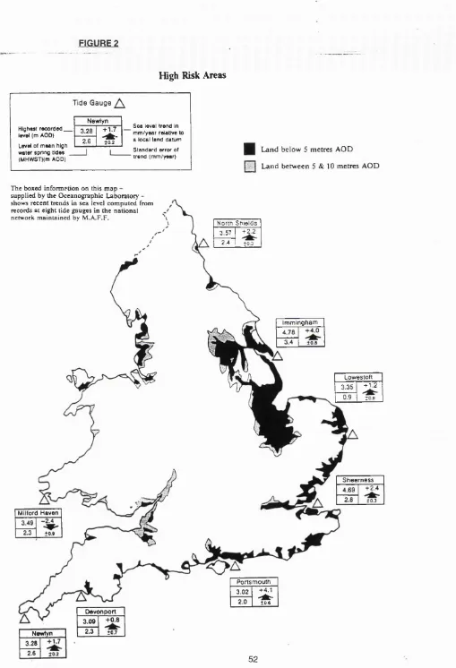
advice includes that regarding development in flood risk areas (DoE Circular 17/92) due to
increasing concerns about the implications of rising sea levels. This is obviously of direct
relevance to the planning of coastal areas. The Government maintains that much of the other
general guidance available applies equally to development in this zone.
2.4.8. There are no planning powers or statutory designations applicable specifically to the
coastal zone. However, a significant proportion of the coast is covered by one or more of a
number of general designations which apply to many areas throughout the country (see Figure
1. in chapter one). These include the National Parks, Areas of Outstanding National Beauty
and Conservation areas, policies for which are defined in Development Plans to enable local
authorities to exercise greater control over development.
2) CONTROL OF DEVELOPMENT BELOW THE LOW WATER MARK
2.4.9. Below low water mark it is not possible to clearly delineate boundaries within which
particular activities or uses may occur. The government believes that in this location it is
therefore impractical to control these uses by means of an overall planning system such as that
in operation on land (House of Commons, 1992b). Additionally there are other factors to be
taken into account when attempting to impose a system of control in respect of the use of the
sea, which do not apply to the land, such as the right of free navigation. Furthermore, since the
variety of uses is considered to be more limited than that occurring on land, giving rise to less
conflict, a system based on regulation according to activity rather than ownership or area has
2.4.10. The complexity of coastal development proposals means that works in tidal waters may
require the consent of up to eight different organisations. The Government recognises the need
for rationalisation of these procedures and is undertaking a review in order to simpiify the system
(House of Commons, 1992b). The requirement for environmental assessment forms part of
these procedures where development is iikely to have a significant effect on the environment
(Haigh, 1987). Consent is required from the Crown Estate Commissioners for almost any
activity on the seabed, (between Mean Low Water Mark and the limit of territoriai waters) or
the half of the foreshore (between high and iow water marks) which forms part of the Crown
Estate. The two activities which have generated the greatest amount of concern are marine
aggregate extraction and marine fish farming.
2.4.11. Marineaggregateextraction is controlled through the non-statutory Government view
Procedure which was revised in 1989 and incorporates environmental assessment. The
Commissioners consult with all interested parties and advertise appiications for production
licences. Ali responses are passed to the Department of the Environment which formulates the
Government View of the proposai, so determining whether the Commissioners issue, subject
to relevant conditions, or refuse the iicence. It is Government poiicy to encourage the use of
such aggregates provided that unacceptable coast erosion or damage to sea fisheries and the
marine environment does not occur.
2.4.12. In respect of marine fish farming, the Crown Estate Commissioners lease some 600
sites, mainly for salmon in Scotiand but aiso for shelifishing around the U.K. coast. The
procedures for issuing such licences involve wide consuitation and incorporate the
Commissioners' responsibilities for environmentai impact assessment under EC rules.
However questions have been raised regarding the dual role of the Commissioners in that they
have the regulatory power to make decisions about the environmental effects and at the same
derive an income from the granting of such ieases. The system was examined by the House
of Commons Seiect Committee on Agricuiture (HC 141 1989-90) and no evidence of serious
environmental damage found. The Government agreed in its response (HC 116 1990-91) that
undertaken, some by the industry itself, into various matters, including environmental effects.
Physical works on land required for fish farms are subject to planning control.
2.4.13. Development affecting navigation: Under the Coast Protection Act 1949, proposed works in tidal waters which would endanger or obstruct navigation require the consent or
approval of the Secretary of State for Transport. The Secretary of State may refuse consent or
grant it subject to conditions but in doing so may only take into account navigational
considerations. Those likely to be affected must be informed and other parties are invited to
comment on the proposals.
2.4.14. Ports: Local Acts or Orders made under the Harbours Act 1964 provide the statutory framework for controlling the commercial and recreational use of the 300 harbours in Great
Britain. The nature and function of Harbour Authorities varies widely. They all require statutory
powers to construct and maintain harbour works below the high water mark, applying to the
Minister for Harbour Orders where their powers are insufficient.They also need a licence under
the Food and Environment Protection Act 1985 for such construction work. An environmental assessment must accompany any application for a Harbour Order involving significant works.
Changes in the Regulations in 1989 brought within the environmental assessment regime those
works which are not authorised by a Harbour Order and where planning permission is not
required (since the works are below low water mark).
2.4.15. Oii and gas extraction: A licence is required under the Petroleum (Production) Act 1934 to carry out such work. Such licences may carry conditions, restrictions or inhibitions on certain activities, reflecting environmental, fishing, defence and transport interests.
2.4.16. Renewable energy sources: Research and development of a number of technologies
utilising tides, wind and wave power and use of seaweed and other marine plants as fuel, are
still taking place. None has as yet been established to be economically viable. As such there
some system of obtaining consents is in place before development is begun. Clearly, such
schemes could potentially have a considerable Impact on the coastal environment.
2.4.17. Recreational craft: Under the Public Health Acts of 1936 and 1961, local authorities
can make byelaws to control such activities up to 1000 metres beyond the low water mark.
These byelaws apply to the use of all craft used for recreational purposes within the area
specified and can therefore be used to regulate speed and hence nuisance caused by some
of the noisier types of modern vessels such as jet skis.
2.4.18. Coastal fisheries: The twelve Sea Fisheries Committees in England and Wales make
byelaws, having powers under the Sea Fisheries Regulations Act 1966, to regulate the taking
offish and shellfish in the interests of fisheries management. These regulations include limiting
the length of vessels and specifying the type of gear which can be used, minimum landing sizes
and areas of restricted fishing. Their jurisdiction extends to three miles from the coast. The NRA
also has the power to make byelaws to protect stocks of migratory fish although such byelaws
require the approval of the appropriate Minister, as do those made by the fisheries committees.
2.4.19. The EC’s Common Fisheries Policy, through EC Regulations, limits the proportion of
stock which may be caught, the type of gear which must be used and the size of vessels
operating within twelve miles of the coast in order to conserve stocks and ensure they are
maintained as a renewable resource. Closed or limited fishing areas are also defined and may
be strengthened by stricter national measures. The Sea Fisheries (Shellfish) act 1967 allows
the granting of Orders, of which there are 24 operating in Great Britain, creating the exclusive
right to cultivate shellfish in specified waters. Release of non-native fish and shellfish into the
wild is controlled by licensing arrangements under the Wildlife and Countryside Act 1981,
3) PRIVATE BILL PROCEDURE
2.4.20. This procedure applies to certain types of development both above and below low water
mark and as of the 1991-92 Parliamentary Session, must include an environmental statement
unless the Secretary of State decides otherwise. It is proposed to introduce legisiation so that
authorisation will be via Ministerial Order rather than private Act and the procedure wiii
incorporate environmental assessment where this is required by EG law (House of Commons,
1992b).
4) PROTECTION OF LANDSCAPE AND WILDLIFE
2.4.21. Landscape and wildlife conservation are the responsibility of the Department of the
Environment and the territorial Departments. In England, poiicy is iargeiy implemented through
the Countryside Commission and Engiish Nature respectively. These functions are combined
in the Countryside Council for Wales, Scottish Natural Heritage and the DoE in Northern ireiand.
2.4.22. Landscape : Much of the undeveloped coastline iies within five of the ten National Parks
and almost half of the thirty-nine Areas of Outstanding Naturai Beauty which were designated
under the National Parks and Access to the Countryside Act 1949. Such designation ailows
stricter controi over new deveiopment where specific policies are incorporated into the reievant
development plans. The Countryside Commission is responsible for promoting public access
to the countryside through designation of long distance footpaths and bridleways. It also
introduced the non-statutory designation of ’Heritage Coasts’ which now covers the third of the
coastline of Engiand and Wales which is considered to be of sufficient quality in terms of scenic
beauty and opportunities for enjoyment by the pubiic. Whiist most of these Heritage Coasts lie
within the other statutorily designated areas, the emphasis is intended to be on management.
540 of the 770km of coastiine under the protective ownership of the National Trust has Heritage
Coast status (Lucas, 1992).
2.4.23. Wildlife: There are over 5,600 Sites of Speciai Scientific Interest (SSSI’S) covering
kms, or 38 per cent of the total area designated occurs within the coastal zone (NCC, 1991).
Designation of such areas by the conservation agencies is the main method of wildlife
conservation, although they can only extend to the boundaries of local authority jurisdiction
which Is the mean low water mark. Local Planning Authorities are required to consult the
agencies and take their views into account when considering applications for certain types of
development. Within each SSSI certain activities known as ’potentially damaging operations’
(P.D.O.’S) may not be carried out unless a management agreement has been entered into or
the consent of the agency has been obtained.
2.4.24. National Nature Reserves (NNR’S) are established by the conservation agencies and
Local Nature Reserves (LNR’S) by local authorities. Most are in private ownership although
some reserves near the coast are managed by voluntary organisations such as the Royal
Society for the Protection of Birds. Areas of Special Protection, which under certain
circumstances may extend beyond the low water mark, can be designated under section 3 of
the Wildlife and Countryside Act 1981 (these provisions were formerly contained within the
Protection of Birds Act 1954). Section 36 of this same Act allows for the designation of Marine
Nature Reserves for conservation or research purposes.
2.4.25. In 1986 the then Nature Conservancy Council identified 14 Marine Consultation Areas
(MCA’S). The NCC then published a document in 1990 which identified a further 15 sites and
outlined the particular distinctions of each in terms of their contribution to the marine
environment. A consultation paper was issued in February 1992 containing a list of proposed
areas in England and Wales where pressures on conservation are strong (DoE, 1992g).
2.4.26. EC Directive 79/409/EEC on the Conservation of Wild Birds requires the designation
of Special Protection Areas (SPA’S) which should extend to the limits of territorial waters. Forty
have so far been designated, twenty-seven of which are on the coast. They are also SSSI’S
and derive their protection through this parallel designation. A possible further 182 have been
identified. Wetlands of international importance are also required to be designated under the
as Wildfowl Habitat, 1971) extending to marine water up to six metres in depth and, similarly,
their existing SSSI status is designed to give them protection. Of the forty-five Ramsar sites so
far listed, twenty-one are on the coast. Two further internationai agreements to which Britain is
signatory are the Berne Convention on the Conservation of European Wiidlife and Naturai
Habitats, 1979 and the Bonn Convention on the Conservation of Migratory Species of Wiid
Animals, 1979.
5) POLLUTION CONTROL
2.4.27. Under the Water Act 1989 water quality objectives must be established and met for all
coastal waters. EC Directives on Sheiifish (79/923/EEC) and bathing Waters (76/160/EEC)
impose a further requirement for coastal waters to achieve certain poilution controi standards.
This latter Directive is impiemented through the Water Resources Act 1991. Over 450 areas
have been identified under this Directive, 77 per cent of which met the standards in 1990
compared with 51 per cent in 1986 (House of Commons, 1992B). Further Directives attempt
to control input of dangerous substances (See appendix A). Internationai agreements aiso exist
to protect the quality of the marine environment, to which we are party. The North Sea
Conferences of 1984,1987 and 1990 reached agreements to reguiate offshore activities, limit
pollution from ships and to protect certain marine species.
2.4.28. On land, the statutory basis for pollution controi in England and Wales is provided by
the Water Act 1989 and the Environmental Protection Act 1990. Integrated pollution control
by Her Majesty’s Inspectorate of Pollution (HMiP) applies to certain processes and requires
the appiication of the "BATNEEC" principle (best available techniques not entailing excessive
cost) in order to control the creation and discharge of wastes, it applies to the substances which
are the most harmful to the environment and are on the United Kingdom’s "Red List". HMiP
must consult the National Rivers Authority (NRA) before granting discharge consents and must
take into account their water quaiity objectives. Aii other discharges into water are controiled
2.4.29. Local authorities are responsible under the 1990 Act for regulation of waste disposal,
discharges to air and land and control of nuisances such as noise, to the landward side of mean
low water mark. Thus local authorities, amongst others, must ensure that publicly accessible
areas, such as beaches above the level of the mean high water tide, are cleaned to the
standards set out in a Code of Practice. The Government is considering setting up a new
Environment Agency for England and Wales, bringing together HMIP, related functions of the
NRA and responsibility for waste regulation.
2.4.30. At sea, disposal of waste is controlled by MAFF under the Food and Environment
Protection Act 1985, in England. The Act requires account to be taken of the need to protect
the marine environment and public health and to prevent interference with legitimate uses of
the sea.
2.4.31. International cooperation is the method employed to prevent pollution from vessels.
Regulations to control sewage from ships and to limit air pollution have not yet come into force.
Regular inspections take place to ensure that standards relating to tanker operation, design
and equipment are complied with. Whilst bearing in mind the international right of innocent
passage around our coasts, improvements are sought in navigation procedures as a way of
reducing the chances of an accident and hence pollution. Two Areas To Be Avoided (ABTA’s)
have been established, which certain vessels may not enter, in order to protect particularly
ecologically sensitive areas. Where this is impractical the Department of Transport relies on
establishing advisory routes.
2.4.32. Major spillages arising from vessels at sea are handled by the Marine Poilution Control
Unit (MPCU) of the Department of Transport which carries out regular air patrols to detect and
deter illegal discharges. When pollution threatens the United Kingdom's beaches, fisheries,
seabirds or ecologically sensitive areas, it is the job of the MPCU to take counter pollution
action. Colour maps showing the distribution of wildlife habitats aiong the coast, particularly
and regional authorities and government departments. Engiish Nature advise the MPCU on the
implications of pollution on wildlife.
6) COAST DEFENCE
2.4.33. In England and Wales, responsibility for coast defence poiicy iies with MAFF and the
Welsh Office respectively. This combines coast protection, the protection of land from erosion
or encroachment by the sea, with the sea defence element of flood defence, which relates to
the prevention of flooding by rivers or the sea.
2.4.34. Coast protection: Under the Coast Protection Act 1949, the reievant district councils
may carry out works approved by the appropriate Minister, in respect of aii works, other than
maintenance, repair and emergency operations, prior consuitation is required with the NRA,
neighbouring district councils, the county council, harbour, navigation and conservancy
authorities, fisheries committees and MAFF. Following receipt of submission for such works,
MAFF consult other Government Departments, the Grown Estate Commissioners, the
Countryside Commission and Engiish Nature. Schemes must also be advertised and a local
inquiry or hearing held if objections are not resolved or withdrawn.
2.4.35. Flood defence: The Land Drainage Act 1976 and the Water Act 1989 provide the
legislative background for the construction, maintenance and improvement of defences against
inland and coastal flooding in Engiand and Wales. This is undertaken by the ten Regional Flood
Defence Committees of the NRA, by local authorities and by the 250 Internal Drainage Boards
which operate in areas with special needs. Authorities are responsible for identifying coastal
defence requirements and carrying them forward. The NRA is responsible for supervising aii
matters relating to flood defence and the district councils are required to consult them about
coast protection works. A coastal defence forum, set up by MAFF and the Welsh Office