Research
Peatland and wetland ecosystems in Peruvian Amazonia: indigenous
classifications and perspectives
Christopher Schulz 1, Manuel Martín Brañas 2, Cecilia Núñez Pérez 2, Margarita Del Aguila Villacorta 2, Nina Laurie 3, Ian T. Lawson 3
and Katherine H. Roucoux 3
ABSTRACT. Many indigenous people hold detailed ecological knowledge about their environment and have developed complex classifications of ecosystem types in their own languages. These classification systems may be based on characteristics including the availability of key resources, salient plant species, and cultural factors, among others. Indigenous environmental knowledge has been of interest to (ethno-)ecologists, geographers, anthropologists, and other scientists looking to learn from indigenous people, especially in newly emerging research topics. We identified and interpreted an ecosystem classification system of the Urarina, a small indigenous nation based in the Chambira River basin, a peatland-rich area of Peruvian Amazonia. Our findings, based on semistructured interviews, participatory mapping exercises, and site visits, indicate that the Urarina distinguish between ecosystems according to vegetation physiognomy, certain (palm) tree species, hydrology, and soil appearance, and that their use of natural resources varies between different ecosystems. Two Urarina ecosystems, jiiri and alaka, are almost certainly associated with the presence of peat soils and are of special cultural significance. The Urarina ecosystem classification system thus offers insights and inspiration for ecologists studying peatlands and other wetlands in the Peruvian Amazon who, thus far, have mostly focused on floristic and structural analyses only. Not least, our research highlights the importance of the peatlands for local people, beyond their role for the global climate system as a substantial carbon store.
Key Words: Amazon; ecosystem classification; indigenous knowledge; Peru; tropical peatlands; Urarina
INTRODUCTION
Through millennia of experience and interaction with certain environments, many indigenous peoples have developed sophisticated and culturally specific environmental knowledge systems (Berkes et al. 1998, Davidson-Hunt and Berkes 2003, Folke 2004, Sileshi et al. 2009). These knowledge systems express themselves not just in the information that indigenous people hold, for example, about traditional medicinal plants, game species, or climate patterns, but also in their daily practices and in their wider beliefs and worldviews, often termed cosmovision, cosmology, or “kosmos” (Toledo 1992, Toledo and Barrera-Bassols 2009). One important element of indigenous environmental knowledge systems is the classification of habitats, ecosystems, or landscapes (Berkes et al. 1998, Omotayo and Musa 1999, Shepard et al. 2001, Davidson-Hunt and Berkes 2003, Duvall 2008, Levinson 2008, Johnson and Davidson-Hunt 2011, Molnár 2013, Wartmann and Purves 2018). Such classification systems rely on various indicators to delimit boundaries between spatial units. These may be related to the vegetation, e.g., the presence of certain salient plant species, or abiotic factors such as soil types, hydrology, or topography of an area. Studies of indigenous classification systems have been conducted in many different contexts around the globe, e.g., to identify rain forest habitats with the Matsigenka of the Peruvian Amazon (Shepard et al. 2001), habitat types recognized by traditional herders in the Hungarian Hortobágy salt steppe (Molnár 2013), physical geographic concepts of Maninka farmers in Mali (Duvall 2008), or the landscape and seascape terminology of the inhabitants of Rossel Island, Papua New Guinea (Levinson 2008).
Interest in indigenous knowledge systems remains strong among ethnoecologists, anthropologists, geographers, environmental social scientists, and policy makers (Pascual et al. 2017, Tengö et al. 2017), even if the boundaries between indigenous and nonindigenous knowledge remain the subject of considerable academic debate (Agrawal 1995, 2009, Leach and Fairhead 2002, Ludwig 2016, 2017, Löfmarck and Lidskog 2017). Studies of indigenous knowledge, including ecosystem classification systems, are considered to be important for at least four reasons:
1. Understanding indigenous ecosystem classifications contributes to making sense of the underlying worldviews that shape naming practices in the first place (Hunn 1996, Duvall 2008, Levinson 2008). Associated with this, linguists, ethnogeographers, and others have made attempts to formulate general theories of place-naming practices (e.g., Hunn 1996, Smith and Mark 2003, Levinson 2008).
2. Indigenous knowledge is frequently viewed as the cultural heritage of indigenous nations that may potentially be lost through processes of cultural assimilation into dominant mainstream societies (Shepard et al. 2001, Hance 2015, Ens et al. 2016). Its documentation through academic research may safeguard this cultural heritage for its intrinsic value, as well as for potential use in education and cultural engagement activities.
3. Indigenous knowledge may be a potential “shortcut” for the development of conventional science, e.g., where local people may have more detailed knowledge of local ecosystems and species than foreign ecologists or a better
understanding of habitats at a local scale (Fleck and Harder 2000, Shepard et al. 2001, Sheil and Lawrence 2004). It may also function as a reference for comparison, dialogue, and a benchmark for the quality of scientific knowledge via ground truthing and cross validation (Robbins 2003, Fernández-Llamazares et al. 2017, Reyes-García et al. 2018), e.g., where local forest types defined by indigenous people are compared with habitat types identified through remote sensing and statistical ecological analysis (Abraão et al. 2008).
4. Awareness of indigenous knowledge is often considered useful for improving environmental management (Stevenson 1996, Berkes et al. 2000, Puri 2007, Sileshi et al. 2009, Steele and Shackleton 2010, Armatas et al. 2016). Sometimes this may be because of its capacity to increase exploitation and production of natural resources, e.g., by increasing agricultural yields via an improved understanding of soil diversity (Rainey 2005, Pereira et al. 2017). It may also inform and strengthen environmental conservation partnerships with indigenous people by adapting conservation measures to local knowledge systems and thereby increasing their acceptance by indigenous partners (Chapin 2004, Sheil and Lawrence 2004, Ens et al. 2016).
Although some authors have stressed a need for describing indigenous knowledge purely on its own terms (e.g., Duvall 2008), most studies in the field still aim to achieve varying levels of dialogue, comparison, or complementarity between indigenous and “scientific” knowledge, not least because boundaries between the two types of knowledge are inevitably arbitrary (Robbins 2003). Evidence of the arbitrary distinction between knowledges is that indigenous knowledge is considered useful for scientific knowledge in the first place, although Ludwig (2017) cautions that there is a risk of crowding out those aspects of indigenous and local knowledge that are deemed “not useful” by Western scientists. Some authors may also prefer the term “science-based knowledge” instead of “scientific knowledge” (e.g., O’Flaherty et al. 2008), possibly to highlight that the boundary between the different knowledge systems is primarily defined by the application of scientific methods. In line with Raymond et al. (2010), we define “indigenous knowledge” as knowledge held by a certain indigenous nation, and, following Andolina et al. (2009:178), we understand it “in sociocultural, relational terms instead of space-bound understandings that fix knowledge to particular local areas.” In this way, we place an emphasis on diverse ways of knowing and processes of learning, where dialogue can be generated between different knowledge communities, across the diversity among indigenous communities, as well as conventional (Western) science.
We contribute to the literature on indigenous ecosystem classification systems with a study of Urarina classifications of their environment in the Loreto Region of Peruvian Amazonia. The Urarina are an indigenous nation of about 3000 members who live in small communities in the Chambira River basin of the Peruvian Amazon, in the challenging environment of nutrient-poor blackwater river systems and associated wetlands, swamps, and seasonally flooded forests, with little perennially
dry land (Kramer 1979, Witzig and Ascencios 1999, Olawsky 2006, Roucoux et al. 2017). Urarina ways of classifying their environment might be of global relevance, given that they live in the midst of what appears to be the largest peatland complex in Amazonia, only recently recognized as such by physical geographers and ecologists. Other tropical peatlands of global relevance are located in the Congo Basin (Dargie et al. 2017) and in Southeast Asia (Couwenberg et al. 2010), and the latter are under threat from fires (Turetsky et al. 2015) and conversion to agriculture, such as oil palm plantations (Koh et al. 2009). The large quantity of carbon processed and stored by these peat-forming wetlands means that they are a significant component of the global climate system (Freitas Alvarado et al. 2006, Lähteenoja et al. 2012, Draper et al. 2014, Roucoux et al. 2017). Thus, we placed special emphasis on identifying whether the boundary between peatland and nonpeatland ecosystems was meaningful to the Urarina.
It has sometimes been suggested that the difficult environment of peatlands has acted as a natural barrier or “shelter” that has helped to maintain the cultural integrity of the Urarina since colonial times (Witzig and Ascencios 1999), even if there are marked differences between different settlement areas, depending on their accessibility (Kramer 1979). Peatlands around the globe play an important part in the cultural imaginary of people who live close to them, because of their distinct physical and ecological features (Lehtinen 2000, Byg et al. 2017), although this aspect tends to be underexplored for tropical peatlands so far. Research on local ecosystem classifications has not yet systematically explored whether terminology for peatland ecosystems exists in indigenous languages, one of the research gaps that we are trying to address. In the Peruvian Amazon, for example, some socio-cultural assessments focus on certain locally known ecosystem types such as aguajales, i.e., palm swamps dominated by the palm species Mauritia flexuosa, locally known as aguaje, which may or may not coincide with the presence of peat in the ground (Gilmore et al. 2013), but there is likely to be some overlap between aguajales and peatland ecosystems (Freitas Alvarado et al. 2006).
patterns, childhood, and adolescence, as well as gender relations (Dean 2009, Walker 2013b). Gender differences are extremely marked (Walker 2013b). For example, only men interact with outsiders, speak (limited) Spanish, wear nontraditional clothes, and have adopted “foreign” pastimes such as playing football. In contrast, most Urarina women do not typically talk to outsiders, do not speak Spanish, do wear traditional clothes, and are, in this way, stewards of the cultural heritage of this indigenous nation (Walker 2013a, b), like women in many other indigenous settings in the wider Amazonian-Andean region (Andolina et al. 2009).
Overall, our aim is to identify and interpret Urarina ecosystem classifications for the first time to help establish the importance of indigenous understandings of peatland and wetland ecosystems to academic debate. This serves several purposes: first, it may help conventional scientists to advance their thinking regarding the classification of ecosystems in the peatland-rich environments where the Urarina traditionally live, the detailed floristic description of which has only recently begun (Lähteenoja et al. 2012, Draper et al. 2018). Second, it gives the first insights into the role and naming of peatlands among local people in the Peruvian Amazon, a research question that has so far not been investigated (Roucoux et al. 2017). Third, it contributes to documenting an aspect of Urarina culture that has so far not been systematically studied, at a time when their cultural heritage is at risk of being lost through weakened interest among younger generations (Olawsky 2006).
MATERIALS AND METHODS
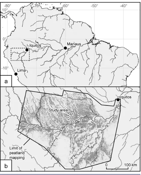
Fieldwork took place in March/April 2018 in the Urarina community of Nueva Unión, located on the Espejo River, one of the tributaries of the Chambira River, which is part of the wider Pastaza-Marañón Basin in the Loreto Region of Peruvian Amazonia (Fig. 1). It consisted of semistructured interviews with community members, participatory mapping exercises, and site visits, which are established methods for the study of indigenous ecosystem classification systems (Johnson and Davidson-Hunt 2011).
In total, 20 semistructured interviews were carried out collaboratively by the first 4 authors of this article with 27 community members overall, representing roughly a third of the overall adult population of the community. Interviewees ranged in age from 18 to 72 years old and included 20 men who were interviewed in Spanish and 7 women who were interviewed in Urarina with the help of a local translator. All male interviewees engaged in hunting, fishing, and small-scale subsistence farming of manioc, plantain, corn, sweet potato, and other crops (see Table 1 for full species names) or had at least some experience with these activities. The majority were also active in the seasonal trade of palm hearts, locally known as chonta, harvested from the wild palm tree species Euterpe precatoria, and aguaje fruit, from the wild palm Mauritia flexuosa (Delgado et al. 2007, Balslev et al. 2008, Smith 2015, Virapongse et al. 2017), and some had been working on the maintenance of an oil pipeline that crosses the community’s territory. Further professions represented were two primary school teachers, who earned a salary from the Peruvian state, and a pastor. Female interviewees were in charge of child care, cooking, collection of firewood,
fishing, washing clothes, and production of traditional textiles, among other activities.
Fig. 1. (a) Location of the Pastaza-Marañón Basin in western Amazonia (dashed box); (b) inset showing the Pastaza-Marañón Basin, with the modeled distribution of peatlands following Draper et al. (2014) in gray. The study area, around the Chambira River basin, is indicated.
The main topics covered in interviews, relevant to us, were (1) natural resource use, especially hunting, fishing, and timber and nontimber (forest) product harvesting; (2) classification of the surrounding environment into various ecosystem categories in the Urarina language and their indicators (see Urarina ecosystem classification for further details); and (3) cultural and mythological importance of certain ecosystem types and associated traditional beliefs and stories. All interviews were recorded and transcribed in Spanish; analytical categories within the interview transcripts were coded with NVivo 11 to facilitate the qualitative analysis.
[image:3.612.315.559.183.485.2]Table 1. List of species.
Scientific Name Local Spanish Name English Name or Approximation
Alouatta seniculus Coto Venezuelan red howler
Attalea butyracea Shebón A palm tree
Biotodoma sp. Bujurqui Cichlid fishes
Bradypus variegatus Oso perezoso Brown-throated sloth
Brycon sp. Sábalo Brycon (a fish)
Caiman crocodilus Lagarto blanco Spectacled caiman
Calophyllum brasiliense Lagarto caspi A tall hardwood tree
Calycophyllum spruceanum Capirona A hardwood tree
Cedrela odorata Cedro A tall timber tree
Chelonoidis denticulata Motelo Yellow-footed tortoise
Choloepus hoffmanni Oso perezoso Hoffmann’s two-toed sloth
Copaifera officinalis Copaiba Hardwood trees
Coussapoa sp. Renaco Hardwood trees
Cuniculus paca Majás Lowland paca
Dasyprocta fuliginosa Añuje Black agouti
Dasypus sp. Carachupa Armadillo
Dracaena guianensis Camaleón Northern caiman lizard
Eunectes murinus Boa Boa/anaconda
Euterpe precatoria Huasaí, chonta A tall palm tree
Ficus sp. Renaco Hardwood trees
Hoplerythrinus unitaeniatus Shuyo Aimara (a fish)
Ipomoea batatas Camote Sweet potato
Iryanthera sp. Cumala Tall timber trees
Manihot esculenta Yuca Manioc
Mauritia flexuosa Aguaje An abundant, tall palm tree
Mazama sp. Venado Deer
Melanosuchus niger Lagarto negro Black caiman
Musa sp. Plátano Plantain
Mylossoma duriventre Palometa Silver mylossoma (a fish)
Nasua nasua Achuni Ring-tailed coati
Pachira brevipes Jiri benüna (in Urarina, i.e., “wood of the jiiri”)
A hardwood tree
Pecari tajacu Sajino Collared peccary
Penelope jacquacu Pucacunga Spix’s Guan (a bird)
Pithecia monachus Huapo negro Monk saki (a monkey)
Prochilodus nigricans Boquichico Black prochilodus (a fish)
Psittaciformes Loro Parrot
Psophia crepitans/leucoptera Trompetero Grey-winged or Pale-winged Trumpeter (a bird)
Saimiri boliviensis Fraile Black-capped squirrel monkey
Simarouba amara Marupá A tall timber tree
Swietenia macrophylla Caoba Mahogany
Tapirus terrestris Sachavaca Tapir
Tayassu pecari Huangana White-lipped peccary
Tinamus major Perdiz Great Tinamou (a bird)
Virola sp. Cumala Tall timber trees
Zea mays Maíz Corn
Additionally, each interview included an individual map-making element, in which interviewees described the areas they had visited, again in view of identifying a local classification system, and the socio-cultural importance of each ecosystem type.
Finally, we also conducted 3 site visits to the various ecosystem types that we identified (see Urarina ecosystem classification) with the guidance of 5 different community members. During these site visits, we had the opportunity to clarify certain characteristics of each ecosystem type in practice and what distinguished ecosystems from each other, especially during the act of crossing from one ecosystem into another. We were also
Fig. 2. A jiiri; this ecosystem consists of “open space” with short vegetation and very soft, waterlogged ground, but note that the jiiri ecosystem may have very diverse appearances.
URARINA ECOSYSTEM CLASSIFICATION
[image:5.612.54.297.134.468.2]Our investigation of Urarina ecosystems yielded a list of 8 main ecosystem types that are recognized by most community members (see Table 2), of which 2 at least sometimes contain peats up to 1.5 m in thickness and which may be consistently peat forming. We briefly describe each ecosystem type; Urarina spellings were confirmed with a local school teacher who had been involved in developing the officially recognized Urarina orthography. A preliminary list of ecosystem types was developed following the participatory mapping workshop with the entire community at the beginning of our fieldwork, with some ecosystems being added during individual interviews with community members. To identify each ecosystem’s unique features and characteristics, we covered a number of potential indicators during interviews, such as vegetation, i.e., physiognomy and species composition; water regime, i.e., seasonal flooding patterns; soils, i.e., color, muddiness, and “sinkiness”; topography; and human uses, i.e., hunting, fishing, and small-scale farming. Because of our special focus on peatlands, we also included questions on walking experiences, i.e., whether it was easy or difficult to walk in each respective ecosystem, and whether there were problems because of sinking in or having one’s boots “sucked” in (in local Spanish:
Fig. 3. An alaka; this ecosystem is defined by the mix of large trees and palm trees, as well as the permanently waterlogged peat soil.
chupadera). Note that for animal and plant species, English names are used where available, and local Spanish names where not. On first appearance, these are complemented with the scientific name (see also Table 1).
Jiiri
The jiiri ecosystem is highly variable in its appearance (see Fig. 2 for an example). It may include small lakes and ponds, areas of grasses and sedges, a mix of aguaje palm trees with areas of pole forest, i.e., closely spaced, low stature, thin-stemmed trees, known to ecologists in Spanish as varillal (Draper al. 2014, 2018), or pole forest without aguaje. This variability may be explained by the fact that the term jiiri represents a rather abstract concept; several interviewees indicated that its meaning is roughly equivalent to “open space.” Consequently, no single translation into local Spanish was given either; the terms aguajal (palm swamp), varillal (pole forest), and pantano (open wetland) were all mentioned in interviews, but there was no clear consensus about the most appropriate translation for jiiri. Aguajal was the most commonly favored Spanish equivalent, but it was also used for the alaka ecosystem (see Urarina ecosystem classification: alaka).
[image:5.612.315.560.136.468.2]Fig. 4. The ground in an elelia. This ecosystem consists of mostly dryland forest dominated by the Attalea butyracea palm species; standing water does exist but is much rarer than in the alaka ecosystem.
characteristics typical of local peatlands: (1) One can sink in easily; probing during one site visit indicated the presence of at least 1.5 m of peat, although our guide indicated that the peat thickness may vary between jiiris. (2) They are permanently waterlogged, though only occasionally flooded by river water. (3) Their pore water is dark and transparent, indicating high concentrations of dissolved organic matter. Colors given for the soil ranged from “reddish,” which is typical of unhumified peats, to black, which is typical of more decomposed peats. To avoid sinking in, one needs to step on roots of trees wherever possible or cut branches or small trees to walk on where available.
[image:6.612.55.296.146.474.2]Short trees from jiiri forest can be used for construction, mainly as roof pillars. Some respondents suggested monkeys could be hunted in jiiris, whereas others said this was not possible because of the absence of trees, this disagreement likely being the result of the variability of jiiri appearances. However, there was a consensus that the jiiri is a good hunting ground for tapirs (Tapirus terrestris) and caimans (Caiman crocodilus and Melanosuchus niger); tapirs may sleep and rest in jiiris, whereas caimans usually stay in the little ponds that make up part of a jiiri. Lizards (Dracaena guianensis) and parrots (Psittaciformes), which in the past were occasionally sold alive to wildlife traders from Iquitos,
Fig. 5. A leuuaku; this ecosystem consists of seasonally flooded forest.
were further mentioned as animals from the jiiri ecosystem. It is also an area where anacondas (Eunectes murinus) can be found, which may only be killed in extremely rare instances of self-defense.
Respondents differed markedly in their assessment of the importance of jiiris for local people. Some highly valued them as a hunting ground and source of aguaje fruit and stressed their cultural importance (see Interpreting indigenous perspectives on ecosystem classification and peatlands: cultural significance of tropical peatlands); others highlighted the difficulties of the terrain and comparatively lower resource availability and expressed a clear preference for alaka and atane ecosystems, among others.
Alaka
The alaka ecosystem is characterized by the dominance of aguaje palm trees, which are interspersed with other large timber trees, such as cumala (Virola sp. or Iryanthera sp., known as kaiajuri in Urarina), and further palm tree species such as shebón (Attalea butyracea) or ungurahui (Oenocarpus bataua). Alaka is thus notably darker than jiiri, as less light passes through the canopy (see Fig. 3). It is possible that the name alaka derives from the Urarina word for aguaje, which is alaa (see also Balslev et al. 2008), but some interviewees explicitly disputed this. Because of the dominance of aguaje palm trees, some respondents used the terms alaka and aguajal, i.e., Mauritia flexuosa palm swamp (see Gilmore et al. 2013), interchangeably. Nevertheless, others suggested that jiiris are aguajales, too, so alaka should not be seen as an exact translation of aguajal.
Table 2. Summary of the characteristics of ecosystem types identified by Urarina interviewees. Where flooding is indicated, this was described as flooding by rivers. “Mud,” fango or barro in local Spanish and itanicha in Urarina, is taken to indicate soft substrates that may include peats and wet clayey and silty soils. Possible equivalent terms from the scientific literature on Peruvian wetland vegetation are tentatively indicated, as are the probable equivalent land-cover classes from Draper et al. (2014), although no formal attempt was made in the field to test their strict equivalence.
Jiiri Alaka Atane Elelia Leuuaku Jierune Kaiajurineeujua Ujuarineeujua
Approximate English equivalent
“Open space” Palm swamp forest Dryland forest Mostly dryland
forest dominated by Attalea
butyracea (shebón,
a palm species)
Seasonally flooded forest
Riparian seasonally flooded low-growth forest
Palm swamp forest dominated by
Virola sp. or Iryanthera sp.
(cumala, a timber tree)
Palm swamp forest dominated by
Euterpe precatoria
(huasaí or chonta, a palm species)
Vegetation physiognomy Highly variable, ranging from grassland to short, thin trees and palm trees
Mix of large timber trees and palm trees
Mix of large timber trees and palm trees
Mix of large timber trees and palm trees
Mix of large timber trees and some palm trees
Short trees and bushes, lianas, very dense vegetation
Mix of large timber trees and palm trees
Mix of large timber trees and palm trees
Important (palm) tree species with local Spanish name
Mauritia flexuosa (aguaje) Mauritia flexuosa (aguaje) No single dominant species, but many timber species Attalea butyracea (shebón) Ficus sp., Coussapoa sp. (renaco) No single dominant species
Virola sp. or Iryanthera sp.
(cumala)
Euterpe precatoria
(huasaí/ chonta)
Virola sp. or Iryanthera sp. (cumala) Attalea butyracea (shebón) Hydrology Permanently wet soils because of groundwater, occasional flooding from river water
Permanently to seasonally wet soils (but less wet than jiiri) because of groundwater and rainfall, rarely flooded from river water
Rarely flooded Rarely flooded Flooded for
several months each year by river water
Flooded for several months each year by river water
Uncertain, but likely similar to
alaka
Uncertain, but likely similar to
alaka
Soil and water color Red to black soil, deep mud, water layer sometimes present beneath root mat
Black to brown soil, deep mud
Brown sandy soil, little mud except after heavy rain
Brown to black soil, shallow muds at most
Brown to black soil, muddy only when flooded
Uncertain, but likely similar to
leuuaku
Black soil Uncertain, but
likely similar to
alaka
Maximum “sinking in” level
Up to chest Up to waist None Feet Feet None Up to knees Above ankles
Main human uses
Mauritia flexuosa
(aguaje): fruit, fiber for textiles
Mauritia flexuosa
(aguaje): fruit, fiber for textiles
Attalea butyracea
(shebón): leaves for roofing Euterpe precatoria (huasaí/ chonta): palm hearts Poles for construction/ roof structures, e.g., Pachira brevipes Timber for construction (floors, walls), e.g.,
Virola sp. or Iryanthera sp. Timber for construction and trade, e.g., Swietenia macrophylla (mahogany), Cedrela odorata (cedro), Calycophyllum spruceanum (capirona) Various timber tree species, e.g.,
Calophyllum brasiliense (lagarto caspi); firewood Poles for construction/ roof structures
Virola sp. or Iryanthera sp. for
construction
Hunting for Tapirus terrestris (tapir), Caiman crocodilus, Melanosuchus niger (spectacled
and black caiman)
Hunting for terrestrial mammals, e.g., Tapirus terrestris (tapir), Pecari tajacu (collared peccary), Tayassu pecari (white-lipped peccary); monkeys, e.g., Saimiri boliviensis (squirrel monkey), Alouatta seniculus (red howler); and birds, e.g.,
Penelope jacquacu
(Spix’s Guan)
Hunting for terrestrial mammals, e.g.,
Mazama sp. (deer), Cuniculus paca (lowland paca), Dasyprocta fuliginosa (black agouti), Dasypus novemcinctus/ kappleri (armadillo); Chelonoidis denticulata (yellow-footed tortoise), monkeys, and birds, e.g., Psophia crepitans/ leucoptera
(Grey-winged or Pale-winged Trumpeter),
Tinamus major
(Great Tinamou)
Hunting for the same animals as in
atane
Fishing with traps, for example:
Hoplerythrinus unitaeniatus
(shuyo), Brycon sp. (sábalo), Prochilodus nigricans (boquichico), Biotodoma sp. (bujurqui), Mylossoma duriventre (palometa)
Fishing with traps
Seeds for necklaces Seeds for necklaces
Alternative names in Peruvian Amazonian Spanish (not necessarily strictly equivalent)
Varillal, aguajal, pantano
Aguajal, shebonal Restinga, yarinal Shebonal Bajial, tahuampa, renacal
Bajial, tahuampa, sogal
Cumalar Chontal
Scientific literature equivalent(s) “Open peatland,”
“open savanna” (Lähteenoja et al. 2009), pole forest/
varillal hidromórfico
(Draper et al. 2014, 2018)
Palm swamp,
aguajal
(Encarnación 1985, Junk and Piedade 2010)
Terra firme forest Not formally described Black water seasonally flooded forest, tahuampa (Encarnación 1985) Riparian seasonally flooded forest, gallery forest Not formally described Not formally described
Equivalent land-cover classes of Draper et al. (2014) Encompasses two
classes: open peatland and pole forest
Palm swamp Terra firme/
occasionally flooded forest Terra firme/ occasionally flooded forest Seasonally flooded forest Seasonally flooded forest
Palm swamp Palm swamp
soil color was described as ranging from brown to black by respondents.
The relatively abundant and large cumala trees are used for construction, e.g., for the floors and walls of houses. One can also find the same small trees for roof structures that are characteristic of jiiris, in between the larger trees. Alaka is comparatively better hunting ground than jiiri, e.g., for tapirs, peccaries, lowland pacas, agoutis, coatis, sloths, and tortoises, as well as monkeys such as howler monkeys, squirrel monkeys, or monk sakis (see Table 1 for all scientific names), many of which are attracted by aguaje fruit and large trees more generally. It is also the ecosystem of choice for the harvesting of aguaje fruit and fiber, for commercialization and domestic textile production, respectively. During aguaje harvesting season, local people may visit alakas to cut aguaje palm trees and sell fruit to traveling traders. Urarina women gather seeds in alakas that they use for decoration and necklaces.
Because of the uses of alakas for hunting and harvesting of timber, fruit, and other nontimber forest products, interviewees generally attributed high importance to them and would regularly visit them. Not least, hunters would regularly have to cross alakas
anyway, given that they surrounded the community where fieldwork took place.
Atane
This ecosystem is named after the Urarina word for “earth,” which is atane. The defining feature of this ecosystem is the absence of prolonged flooding, i.e., beyond 1-2 days per year, or waterlogging of soils, in contrast to jiiri, alaka, and, to a lesser extent, elelia. The soil is usually brown, firm, and dry. If untouched, atane is generally covered in rain forest with large trees, but it is also the preferred location for setting up chacras, small-scale agricultural fields, and the communities themselves. Atane is close to synonymous with what is called restinga elsewhere in Peruvian Amazonia (Encarnación 1985), and many respondents used the two words interchangeably.
armadillos, as well as a variety of bird species, such as Spix’s Guans, Grey-winged or Pale-winged Trumpeters, and Great Tinamous, which are less common in alaka and cannot usually be found in jiiris (see Table 1 for scientific names). Atane also offers the best variety of timber tree species for construction, including, but not limited to, cumala (i.e., Virola sp. or Iryanthera sp. of better quality than cumala from alaka), mahogany (Swietenia macrophylla, known as caoba in local Spanish), cedro (Cedrela odorata), marupá (Simarouba amara), copaiba (Copaifera officinalis), or capirona (Calycophyllum spruceanum). Older respondents noted a strong decline in the availability of these commercially valuable trees over the past few decades, although capirona could potentially be managed, as is already the case elsewhere in the Peruvian Amazon (Weber and Sotelo Montes 2005, Sotelo Montes et al. 2008).
Atane is considered a scarce and, in this sense, valuable ecosystem type among local community members. This was made clear in interviews when some respondents reported having to travel more than an hour to reach their chacras in an atane area. Furthermore, the search for atane motivated a move of the entire community about 25 years ago, as the previous location, about 30 minutes downstream by engine-powered canoe, or peque peque, did not offer enough atane for the growing population to build houses. Moving communities is a common practice among the Urarina, and although it is possible to protect houses from flooding by building them on stilts, the Urarina still exclusively choose to build communities in nonflooded, i.e., atane, areas, as Kramer (1979) noted 40 years ago. Indeed, a neighboring Urarina community had just moved to a different location shortly before we visited.
Elelia
The elelia ecosystem is dominated by the palm tree species locally known as shebón. Very likely, the name derives from the Urarina word for this palm tree, which is ele. In its appearance, elelia has similarities with alaka and atane, i.e., palm trees are mixed with other large trees, and elelia is only rarely flooded by river water. The soil ranges in color from brown to black and is less soft underfoot than in jiiri or alaka, probing being possible only to a depth of ∼20 cm (see Fig. 4). Although the soil is typically moist, standing water is much rarer than in alaka. Respondents noted that one cannot typically find aguaje in elelia, although other palm trees such as huasaí or chonta (Euterpe precatoria) are present. The name elelia could be translated into Spanish as shebonal. Although the “sinky,” wet ground is superficially similar to peatland ecosystems, and respondents mentioned elelia alongside jiiri and alaka as an example of “muddy” places, i.e., potential peatland areas, the examples of elelia that we visited had too thin an organic soil layer to be considered as peat forming.
Elelia is an important place for the harvesting of shebón leaves, which are used to cover the roofs of traditionally built houses. It is also a good hunting ground, where most game species can be found, similar to atane and alaka. Respondents mentioned monkeys, birds, agoutis, and tortoises, among others. Some female interviewees also said they could find seeds for decoration and necklaces in this ecosystem. Elelia can be found right next to the community, but overall, it appears to cover less area than the ecosystems described in the previous sections.
Leuuaku
The leuuaku ecosystem (see Fig. 5) shares many characteristics with atane, including the brown color of its soil, which is solid and dry when not flooded, as well as the vegetation cover consisting of mainly large trees, mixed with some shorter trees, and some palm trees. The main difference is that leuuaku is seasonally flooded by river water, because it is located at a lower topographic level than atane. In this sense, “seasonally flooded forest” might be an appropriate translation into English. In contrast to the atane ecosystem, renaco trees, i.e., large trees with aerial roots, such as Coussapoa sp. and Ficus sp., which are well adapted to seasonal flooding, can be found in leuuaku. Some interviewees mentioned that leuuaku is synonymous with what is called tahuampa elsewhere in the Peruvian Amazon, i.e., flooded forest, or alternatively, bajial, i.e., a low-lying area prone to flooding (Encarnación 1985). However, although very similar in meaning, these terms cannot be considered synonymous, because they miss the more fine-grained differences with the jierune ecosystem (see Urarina ecosystem classification: jierune). Furthermore, the term tahuampa is only applied to seasonally flooded forest when flooded (Encarnación 1985), whereas leuuaku is recognized as leuuaku even when not currently flooded. Because of the solid ground, it appears unlikely that the leuuaku ecosystem is typically peat forming, which agrees with the provisional view from the limited scientific surveys that peat-forming seasonally flooded forests, though not unknown, are rare in Peruvian Amazonia (Draper et al. 2014).
The main resources of leuuaku are fish, which are caught with traps when the area is under water and the fish can feed on fruit and seeds from flooded trees. Examples of common fish species found in leuuaku are shuyo (Hoplerythrinus unitaeniatus), sábalo (Brycon sp.), boquichico (Prochilodus nigricans), bujurqui (Biotodoma sp.), or palometa (Mylossoma duriventre). When not flooded, in a similar way to atane, leuuaku can be used for hunting. One can also find wood and timber, most importantly lagarto caspi (Calophyllum brasiliense), but also capirona and cumala, among others. Leuuaku is popular for collecting firewood, and no respondent considered this ecosystem to be unimportant.
Jierune
The jierune ecosystem can typically be found just next to rivers and streams. It is a low-lying area covered in thick vegetation of small trees and bushes and is seasonally flooded just like leuuaku. Some respondents had difficulties in specifying the differences between jierune and leuuaku, and others suggested that the name could be translated again as bajial or tahuampa (see Urarina ecosystem classification: leuuaku). Nevertheless, it appears that leuuaku and jierune are distinguished by their location (i.e., jierune is more likely to be located immediately next to a river) and vegetation physiognomy (i.e., jierune has much more dense vegetation with a much lower canopy, on average). Jierune may also contain some renacos, i.e., individual large trees with large aerial roots, and lianas, and one interviewee suggested that jierune could be translated as sogal, i.e., area where lianas grow.
characteristics of this ecosystem. Nevertheless, jierune is a potential source for small trees that can be used for construction, especially roof structures, similar to jiiri.
Kaiajurineeujua
The kaiajurineeujua ecosystem is defined by an abundance of cumala trees (Virola sp. or Iryanthera sp.), called kaiajuri in Urarina. The suffix neeujua likely means “a lot” in this context. Beyond the abundance of cumala, kaiajurineeujua seems to be very similar to alaka; that is, it is a mix of large timber trees and palm trees, with dark and possibly “sucking”, i.e., chupadera, ground. It is unclear whether kaiajurineeujua should be seen as an ecosystem type at the same hierarchical level as, for example, alaka, or whether it represents merely a slight floristic variation within alaka; it was reported by some respondents to be located “inside alaka.” Nonetheless, the distinction is important to the local community because cumala appears to be the most popular timber tree species, used for house floors and walls and occasionally sold to traders. Most interviewees also readily translated kaiajurineeujua into local Spanish as cumalar, i.e., place where cumala trees grow. This ecosystem may be peat forming given the cited soil characteristics and overall similarity with alaka. However, it was not possible to visit a kaiajurineeujua during site visits. Like elelia, this ecosystem appears to cover only smaller areas.
Ujuarineeujua
The ujuarineeujua ecosystem is characterized by an abundance of huasaí or chonta (Euterpe precatoria), called ujuari in Urarina. Again, respondents mentioned that it may be located “inside alaka”; that is, it is again unclear whether ujuarineeujua should be seen as a separate ecosystem or, rather, a subtype of alaka. The name could be translated as chontal into local Spanish. Overall, we do not have much information about ujuarineeujua, as respondents noted that it is not very common in the area. It was not mentioned during the participatory mapping workshop with the whole community at the beginning of our fieldwork, but rather in individual interviews with community members, and we were unable to visit it in person to verify its characteristics. Nevertheless, ujuari, or chonta, represents an important economic resource for local community members because it is harvested for its palm hearts and occasionally sold to visiting traders. In the study location, however, it appears that ujuari is mainly harvested from other ecosystems such as elelia, where individual palm trees of this species can be found.
INTERPRETING INDIGENOUS PERSPECTIVES ON ECOSYSTEM CLASSIFICATION AND PEATLANDS Having presented an Urarina classification of the ecosystems of their surrounding environment in the preceding section, we connect our findings to broader academic debates. As outlined in the introduction, our findings may be of relevance to at least four broad themes, i.e., place naming, cultural heritage conservation, dialogue with scientific knowledge, and ecosystem management and conservation.
Naming places and ecosystems
Evidently, no single criterion is used in the Urarina ecosystem classification system to delimit the boundaries between various ecosystems. Important abiotic indicators include the hydrologic regime, e.g., to delimit the boundary between atane and leuuaku, and soils, which are the unifying feature across the various forms
of jiiri. Topography matters in so far as it may determine flooding levels. Important biotic factors are individual palm tree species (aguaje, shebón, and chonta); the tree species cumala, which could be understood as “cultural keystone species” (Garibaldi and Turner 2004; see Interpreting indigenous perspectives on ecosystem classification and peatlands: cultural significance of tropical peatlands); but also vegetation physiognomy, e.g., because jierune is defined by shorter and denser vegetation than leuuaku.
Competing theories for the development of landscape terminology exist, which are likely to be relevant for ecosystem terminology more specifically as well. Levinson (2008), for example, suggests that perceptual salience of certain features, human uses, and cultural factors may all play a role (cultural factors are discussed subsequently). Clearly, all three factors are relevant, although it may sometimes be difficult to determine their relative importance. For example, jiiris are perceptually different through the reddish to black ground where one can only walk with great difficulty, as well as the comparatively lower height of the vegetation; however, they are also known as hunting grounds for caimans and tapirs and could in this way be interpreted as a resource area. Similarly, the main difference between atane and leuuaku is the presence of seasonal flooding in the latter, but leuuaku is also known for the abundance of fish as a specific resource that can be caught with traps when flooded. Thus, salience and human uses are closely interwoven.
Conversely, elelia, kaiajurineeujua, and ujuarineeujua are primarily known as specific places to locate a certain natural resource and, in this sense, could be interpreted as “resource islands” embedded in the broader environment, such as, e.g., “the forest” (Posey 1985, Gilmore et al. 2013). Their simple definition as a “place where dominant resource plant species X can be found” is similar to naming conventions elsewhere in the Amazon, as reported by, e.g., Wartmann and Purves (2018), who also found that a large number of indigenous ecosystem types were named after a single plant species. This is in fact similar to naming practices in the English language, too, where one may speak of, e.g., “oak forest” or “beech forest.”
Cultural significance of tropical peatlands
As Levinson (2008) noted, cultural factors may also play a significant role in developing classificatory systems for landscapes and ecosystems. We place special emphasis on the cultural significance of peatland areas, an understudied field of research across tropical climate zones. Furthermore, this aspect of the research also contributes to documenting a relevant aspect of Urarina culture that might be at risk of being lost through cultural assimilation, this documentation and “safeguarding” being the objective of much research on indigenous knowledge (Shepard et al. 2001, Hance 2015, Ens et al. 2016).
Interestingly, one such “mother” or spirit recognized by the Urarina, the Baainu, lives in both alaka and jiiri ecosystems, i.e., the two main ecosystems that are most likely peatland ecosystems. As many interviewees testified, the Baainu may make people lose their way in the jiiri and alaka by calling an unlucky person’s name, disguising its voice, and pretending to be a family member. Ultimately, the Baainu seeks to transform the (human) person into a Baainu. The Baainu may also steal items from hunters, such as machetes. The name Baainu might be related to witchcraft, given that Dean (1999) translates the word bainee as “sorcery.” The Baainu’s strategy was told to us as follows by one community member:
Sometimes, when the Baainu wants to take you, and you are following some animal, such as a white or black monkey, he will confuse you and you follow the animal, thinking that you’re going a short distance, when actually, it is not. “Where is it?” you start wondering. Jiiri and alaka have the same mother, and he [i.e., the mother/ Baainu who is both male and female] takes you to his very nice house, the pillars of which are built with the trunk of an aguaje palm tree. Under it, you can see aguaje fruit that he will eat. There are also white monkeys sitting on both shoulders of the mother, and an animal that looks like a jaguar can be seen, too, chained and with its mouth well tied up. Your family members will be looking for you, but the Baainu will tell you not to listen to the noise and he will confuse you. You will see a beautiful house, nice houses, and it does not appear muddy. You can feel that there is a good soil, and the houses look really very nice. The animal from the Baainu’s shoulder will want to jump on your shoulder and sit there; but if it does jump and sits on your shoulder, you will never see your relatives ever again. Your family will look for you and for someone who knows how to drink ayahuasca, and through that [i. e., drinking ayahuasca], the Baainu will say: “Before I make you eat with these animals, I will take you to your house, so you can go home. I don’t like it when they call me like this.” Having said that, he will take you and put you back to the place where he found you. [...] But if your family does not search for you, well, then you will stay there forever.
Not all interviewees were willing to answer questions about the Baainu, and some stated that they had no knowledge of it; this reluctance to respond or loss of knowledge may potentially be related to the loss of traditional belief systems or their replacement with evangelical Christian beliefs, introduced by Argentinean and U.S. missionaries (Olawsky 2006). In other cases, people may have not been willing to share their personal beliefs with a stranger. The Baainu story has many similarities with the traditional belief in the Chullachaqui across Amazonia, an evil spirit that makes people lose their way by taking up the appearance of a different person (Larochelle 2012, Smith 2015), known by many different names (Burton 2018). In contrast to the Baainu, however, the Chullachaqui is known as the “guardian spirit of the forest” (Larochelle 2012), i.e., it is not usually associated with palm swamp and peatland ecosystems such as jiiri and alaka. The Maijuna of the Peruvian Amazon do know an evil spirit that lives in palm swamps, the Gogobai, who may abduct local people (Gilmore et al. 2013). However, the Gogobai aims to
eat its victims, which is not the case for the Baainu. Thus, each mythological figure has some unique features, and descriptions even for the same spirit may vary between people and communities (see also Walker 2013b). This suggests that indigenous knowledge is not “fixed,” and that there is a contrast not only between indigenous and scientific knowledge but also between various indigenous knowledges, i.e., between different indigenous peoples, as well as within one indigenous nation. In this sense, indigenous knowledge should be seen in relational terms, rather than space bound and clearly defined (Andolina et al. 2009). It also implies that our description of the cultural heritage, as well as of the Urarina ecosystem categories themselves, can always only be an approximation or simplification of the diversity of indigenous knowledges.
Beyond the Baainu spirit of jiiri and alaka, peatland areas have further special cultural significance to the Urarina, given that they are the source of aguaje palm tree fiber, which Urarina women use for the production of traditional textiles, known as cachihuango elsewhere in the Peruvian Amazon (Morales Chocano 2004). These textiles are of central importance to Urarina culture and cosmology, and in this way, aguaje could be understood as a “cultural keystone species,” given the central importance of this species for both ecology and culture in the area (Garibaldi and Turner 2004). Dean (1994) recounts the Urarina creation myth, which involves an episode in which the distinction between “ignorant” and “wise” women is described as their ability to make fiber cloth. The practice of weaving these palm-fiber cloths continues today, even if most Urarina women now wear clothes made from cotton.
Lessons learned for ecology and conventional science
potentially be another opportunity for learning from indigenous environmental knowledge (see also Abraão et al. 2008).
Comparison of the terms used by Draper et al. (2014, 2018) and the Urarina (Table 2) suggests both similarities and differences. The Urarina appear to consider both “open peatlands” and “peatland pole forest” to be constituents of jiiri, perhaps because the structural mix of herbs, shrubs, and trees shows rather continuous variation and because the types of resources, such as caiman and tapirs, found throughout the jiiri are the same. From a scientific point of view, the ecological and floristic relationships between open peatlands and peatland pole forests remain an open question: To our knowledge, no formal botanical description of an open peatland has yet been undertaken, and it is not yet clear whether the two (possibly end-member) environments typically form part of a temporal succession or some other kind of physical or chemical gradient. Conversely, our interviewees named two subcategories of palm swamp, kaiajurineeujua and ujuarineeujua, which are characterized by particular tree species that are important resources to them. The prevailing scientific classification risks playing down the significance of the swamp forests for the people who rely on them for their subsistence. The Urarina ecosystem classification explicitly incorporates human ecology and is in this sense more holistic than current scientific classification systems as is often the case in indigenous or traditional ecosystem classifications (Berkes et al. 1998).
The terms “open peatland” and “peatland pole forest,” increasingly important in the scientific literature on carbon storage, do not have direct equivalents in the Urarina language, which poses a challenge for scientists in communicating with local community members. However, it is also interesting that although peat itself does not have any local uses, unlike in northern countries such as Scotland or Finland, it seems that the boundary between jiiri and alaka on the one hand, and other ecosystem types on the other, does indeed coincide with the presence of peat in the ground. Further interdisciplinary research would be desirable to establish whether there is such a link between indigenous knowledge and scientific understanding of soils.
Ecosystem management, conservation, and socioeconomic development implications
As many scholars have noted, studying indigenous knowledge may contribute to better ecosystem management and environmental conservation (Stevenson 1996, Berkes et al. 2000, Chapin 2004, Folke 2004, Sheil and Lawrence 2004, Puri 2007, Sileshi et al. 2009). On a very basic level, learning an indigenous terminology may help with communication across cultural and epistemological differences (Omotayo and Musa 1999). Any outside actor engaging in environmental management and conservation activities in Urarina territory will benefit from understanding that the community has a sophisticated view of its own environment, reflecting the value of the many resources that the community uses through local ways of classifying the environment, and that it does not see the environment in exactly the same way as scientists or development workers schooled in a different tradition. Better communication between outsiders and local communities may make for more effective collaborations, with community priorities and aspirations better recognized from the outset and scientists better able to translate their ideas into mutually intelligible terms (Ens et al. 2016). There may also be
connections between spatial and temporal aspects, i.e., indigenous ecosystems and aspects of seasonality, or phenology, e.g., in the form of seasonal fishing activities in the leuuaku or harvesting calendars for particular resources, with potential implications for environmental management and adaptation to environmental change (Davidson-Hunt and Berkes 2003, Gómez-Baggethun et al. 2013, Armatas et al. 2016).
Our work has shown that much of Urarina culture is intimately linked to their environment. Myths, legends, and stories about the different ecosystems, such as the Baainu described previously, or the notion that certain plant species have “owners” or “mothers,” i.e., guardian spirits, which pose a threat to humans, but which, if respected, indirectly help with the conservation of natural resources (see Interpreting indigenous perspectives on ecosystem classification and peatlands: cultural significance of tropical peatlands), are shared, to a varying extent, among members of the community and thus are part of their social identity. This brings a human dimension to the landscape that is currently lacking from the literature on biodiversity and carbon conservation on Amazonian peatlands (Roucoux et al. 2017), although it has previously been noted that indigenous ecosystem classifications are often better suited to capture social-ecological dynamics than conventional ecology (Berkes et al. 1998). If we value diversity in human culture, the strong link between Urarina culture and their environment provides an additional reason for conserving, or at least carefully managing development in, Amazonia’s wetland environments.
The apparent respect for jiiri and alaka evidenced by their “ambiguous” cultural position, i.e., valued but also feared, suggests that there may be synergies between cultural protection and biodiversity and carbon conservation. In the current context of calls to vastly increase the scope of protected areas that limit or even exclude people (Wilson 2016), it is important that future research engages actively with the communities living in these areas. This is especially important in quantitative studies that aim to address how biodiversity and carbon stocks are affected by the presence and activities of indigenous and more recent settler communities. Emphasizing their voices in these studies will help strengthen their own management of diverse peatland-rich environments.
CONCLUSIONS
This knowledge could potentially be used for communication between scientists and local people, as well as for improved environmental management and conservation. It could also be the basis for further participatory mapping exercises, including participatory GIS (Chapin et al. 2005, Olson et al. 2016) and detailed vegetation surveys in the various Urarina ecosystems, to gain a better understanding of the spatial aspects of the various ecosystems and traditional land uses and how they compare with existing remote-sensing-based maps and ecological classifications (i.e., Draper et al. 2014, 2018).
Two Urarina ecosystems, jiiri and alaka, appear to be peatlands and, moreover, hold a central position in Urarina culture as the home of the mythical creature called Baainu, which may trick and trap people who may get lost in the difficult terrain. Culturally, peatlands thus occupy an ambiguous position for the Urarina, because they are not only dangerous places but also places for hunting caimans and tapirs, where the commercially valuable aguaje fruit can be harvested, and where women can find aguaje fiber to produce traditional textiles. In this way, tropical peatlands may be similar to peatlands in European countries, which are also perceived as culturally ambivalent spaces (Lehtinen 2000, Byg et al. 2017). This may suggest that the particular geography of peatlands may shape human perceptions across cultural and climatic boundaries.
Describing an Urarina classification system also opens up the possibility to use these categories in future scientific research that aims to close some of the existing gaps that we have exposed. Abraão et al. (2008) have noted that already Amazonian ecosystem classification borrows heavily from local terms (e.g., Encarnación 1985). Jiiri and alaka could potentially become scientifically defined terms, in this way demonstrating that indeed boundaries between indigenous and scientific knowledge are arbitrary, and that the two can often complement each other very well.
Responses to this article can be read online at:
http://www.ecologyandsociety.org/issues/responses.
php/10886
Acknowledgments:
The authors would like to thank the community of Nueva Unión, Loreto, Peru, for participating in this research. Particular thanks go to Samuel Nuribe for confirming Urarina spellings for this article. We would also like to thank Michael Gilmore for advice on participatory mapping, and Harry Walker for advice on doing research in Urarina communities. Thanks are also due to Eurídice Honorio Coronado, Tim Baker, Jhon del Aguila Pasquel, Gabriel Hidalgo, and Marcos Ríos for advice on the ecology of the area, Greta Dargie for advice on peat and peatland characteristics, and Freddie Draper for access to data. We gratefully acknowledge funding from the Scottish Funding Council, the Natural Environment Research Council (NE/R000751/1), and the University of St Andrews.
LITERATURE CITED
Abraão, M. B., B. W. Nelson, J. C. Baniwa, D. W. Yu, and G. H. Shepard, Jr. 2008. Ethnobotanical ground-truthing: indigenous knowledge, floristic inventories and satellite imagery in the upper Rio Negro, Brazil. Journal of Biogeography 35(12):2237-2248. https://doi.org/10.1111/j.1365-2699.2008.01975.x
Agrawal, A. 1995. Dismantling the divide between indigenous and scientific knowledge. Development and Change 26(3):413-439. https://doi.org/10.1111/j.1467-7660.1995.tb00560.x
Agrawal, A. 2009. Why "indigenous" knowledge? Journal of the Royal Society of New Zealand 39(4):157-158. https://doi. org/10.1080/03014220909510569
Andolina, R., N. Laurie, and S. A. Radcliffe. 2009. Indigenous development in the Andes: culture, power, and transnationalism. Duke University Press, Durham, North Carolina, USA. https:// doi.org/10.1215/9780822391067
Armatas, C. A., T. J. Venn, B. B. McBride, A. E. Watson, and S. J. Carver. 2016. Opportunities to utilize traditional phenological knowledge to support adaptive management of social-ecological systems vulnerable to changes in climate and fire regimes. Ecology and Society 21(1):16. https://doi.org/10.5751/ES-07905-210116 Balslev, H., C. Grandez, N. Y. Paniagua Zambrana, A. L. Møller, and S. L. Hansen. 2008. Palmas (Arecaceae) útiles en los alrededores de Iquitos, Amazonía Peruana. Revista Peruana de Biología 15(3):121-132. https://doi.org/10.15381/rpb.v15i3.3343 Berkes, F., J. Colding, and C. Folke. 2000. Rediscovery of traditional ecological knowledge as adaptive management. Ecological Applications 10(5):1251-1262. https://doi.org/10.1890/1051-0761 (2000)010[1251:ROTEKA]2.0.CO;2
Berkes, F., M. Kislalioglu, C. Folke, and M. Gadgil. 1998. Exploring the basic ecological unit: ecosystem-like concepts in traditional societies. Ecosystems 1(5):409-415. https://doi. org/10.1007/s100219900034
Burton, A. 2018. Who’s afraid of the Curupira? Frontiers in Ecology and the Environment 16(5):308. https://doi.org/10.1002/ fee.1817
Byg, A., J. Martin-Ortega, K. Glenk, and P. Novo. 2017. Conservation in the face of ambivalent public perceptions – the case of peatlands as ‘the good, the bad and the ugly.’ Biological Conservation 206:181-189. https://doi.org/10.1016/j.biocon.2016.12.022 Cajas Rojas, J., A. Corbera, B. Gualdieri, and G. Solis. 1987. Bibliografía etnolingüística urarina. Instituto de Lingüística Aplicada (CILA), Universidad Nacional Mayor de San Marcos, Lima, Peru.
Chapin, M. 2004. A challenge to conservationists. World Watch 17(6):17-31. [online] URL: http://www.worldwatch.org/node/565
Chapin, M., Z. Lamb, and B. Threlkeld. 2005. Mapping indigenous lands. Annual Review of Anthropology 34:619-638. https://doi.org/10.1146/annurev.anthro.34.081804.120429
Couwenberg, J., R. Dommain, and H. Joosten. 2010. Greenhouse gas fluxes from tropical peatlands in south-east Asia. Global Change Biology 16(6):1715-1732. https://doi.org/10.1111/ j.1365-2486.2009.02016.x
Dargie, G. C., S. L. Lewis, I. T. Lawson, E. T. A. Mitchard, S. E. Page, Y. E. Bocko, and S. A. Ifo. 2017. Age, extent and carbon storage of the central Congo Basin peatland complex. Nature 542 (7639):86-90. https://doi.org/10.1038/nature21048
Davidson-Hunt, I., and F. Berkes. 2003. Learning as you journey: Anishinaabe perception of social-ecological environments and adaptive learning. Conservation Ecology 8(1):5. https://doi. org/10.5751/ES-00587-080105
Dean, B. 1994. The poetics of creation: Urarina cosmogony and historical consciousness. Latin American Indian Literatures Journal 10(1):22-45.
Dean, B. 1999. Intercambios ambivalentes en la Amazonia: formación discursiva y la violencia del patronazgo. Anthropologica 17(17):85-115. [online] URL: http://revistas.pucp. edu.pe/index.php/anthropologica/article/view/1539
Dean, B. 2009. Urarina society, cosmology, and history in Peruvian Amazonia. University of Florida Press, Gainesville, Florida, USA. https://doi.org/10.5744/florida/9780813033785.001.0001
Delgado, C., G. Couturier, and K. Mejia. 2007. Mauritia flexuosa (Arecaceae: Calamoideae), an Amazonian palm with cultivation purposes in Peru. Fruits 62(3):157-169. https://doi.org/10.1051/ fruits:2007011
Díaz Barba, A. 1987. La chawa de chacra urarina. Una técnica tradicional de agricultura amazónica. Boletín de Lima 49:65-72.
Draper, F. C., E. N. Honorio Coronado, K. H. Roucoux, I. T. Lawson, N. C. A. Pitman, P. V. A. Fine, O. L. Phillips, L. A. Torres Montenegro, E. Valderrama Sandoval, I. Mesones, R. García-Villacorta, F. R. Ramirez Arévalo, and T. R. Baker. 2018. Peatland forests are the least diverse tree communities documented in Amazonia, but contribute to high regional beta-diversity. Ecography 41(8):1256-1269. https://doi.org/10.1111/ecog.03126 Draper, F. C., K. H. Roucoux, I. T. Lawson, E. T. A. Mitchard, E. N. Honorio Coronado, O. Lähteenoja, L. Torres Montenegro, E. Valderrama Sandoval, R. Zárate, and T. R. Baker. 2014. The distribution and amount of carbon in the largest peatland complex in Amazonia. Environmental Research Letters 9 (12):124017. https://doi.org/10.1088/1748-9326/9/12/124017
Duvall, C. S. 2008. Classifying physical geographic features: the case of Maninka farmers in southwestern Mali. Geografiska Annaler: Series B, Human Geography 90(4):327-348. https://doi. org/10.1111/j.1468-0467.2008.00297.x
Encarnación, F. 1985. Introducción a la flora y la vegetación de la Amazonía peruana: estado actual de los estudios, medio natural y ensayo de una clave de determinación de las formaciones vegetales en la llanura amazónica. Candollea 40(1):237-252.
Ens, E., M. L. Scott, Yugul Mangi Rangers, C. Moritz, and R. Pirzl. 2016. Putting indigenous conservation policy into practice delivers biodiversity and cultural benefits. Biodiversity and Conservation 25(14):2889-2906. https://doi.org/10.1007/s10531-016-1207-6
Fabiano, E. 2015. "Le corps mange, tout comme la pensée soigne": construction des corps et techniques de contamination dans la pratique chamanique Urarina. Dissertation. École des Hautes Études en Sciences Sociales (EHESS), Paris, France.
Fernández-Llamazares, Á., R. Amaral Garcia, I. Díaz-Reviriego, M. Cabeza, A. Pyhälä, and V. Reyes-García. 2017. An empirically tested overlap between indigenous and scientific knowledge of a changing climate in Bolivian Amazonia. Regional Environmental Change 17(6):1673-1685. https://doi.org/10.1007/s10113-017-1125-5 Fleck, D. W., and J. D. Harder. 2000. Matses Indian rainforest habitat classification and mammalian diversity in Amazonian Peru. Journal of Ethnobiology 20(1):1-36. [online] URL: https:// ethnobiology.org/sites/default/files/pdfs/JoE/20-1/FleckHarder.pdf
Folke, C. 2004. Traditional knowledge in social–ecological systems. Ecology and Society 9(3):7. https://doi.org/10.5751/ ES-01237-090307
Freitas Alvarado, L., E. Otárola Acevedo, D. del Castillo Torres, C. Linares Bensimón, P. Martínez Dávila, and G. A. Malca Salas. 2006. Servicios ambientales de almacenamiento y secuestro de carbono del ecosistema aguajal en la Reserva Nacional Pacaya Samiria, Loreto - Perú. Documento Técnico No. 29, Instituto de Investigaciones de la Amazonía Peruana, Iquitos, Peru. [online] URL: http://repositorio.iiap.org.pe/handle/IIAP/228
Garibaldi, A., and N. Turner. 2004. Cultural keystone species: implications for ecological conservation and restoration. Ecology and Society 9(3):1. https://doi.org/10.5751/ES-00669-090301 Gilmore, M. P., B. A. Endress, and C. M. Horn. 2013. The socio-cultural importance of Mauritia flexuosa palm swamps (aguajales) and implications for multi-use management in two Maijuna communities of the Peruvian Amazon. Journal of Ethnobiology and Ethnomedicine 9:29. https://doi.
org/10.1186/1746-4269-9-29
Gómez-Baggethun, E., E. Corbera, and V. Reyes-García. 2013. Traditional ecological knowledge and global environmental change: research findings and policy implications. Ecology and Society 18(4):72. https://doi.org/10.5751/ES-06288-180472 Hance, J. 2015. Amazon tribe creates 500-page traditional medicine encyclopedia. Mongabay, 24 June. [online] URL: https:// news.mongabay.com/2015/06/amazon-tribe-creates-500-page-traditional-medicine-encyclopedia/
Hunn, E. 1996. Columbia Plateau Indian place names: what can they teach us? Journal of Linguistic Anthropology 6(1):3-26. https://doi.org/10.1525/jlin.1996.6.1.3
Johnson, L. M., and I. Davidson-Hunt. 2011. Ethnoecology and landscapes. Pages 267-284 in E. N. Anderson, D. Pearsall, E. Hunn, and N. Turner, editors. Ethnobiology. Wiley-Blackwell, Hoboken, New Jersey, USA. https://doi.org/10.1002/9781118015872. ch16