A participatory modelling approach to
developing a numerical sediment
dynamics model
Nicholas David Jones
A thesis submitted in partial fulfilment of the requirements of the University of the West
of England, Bristol, for the degree of Doctor of Philosophy. Faculty of Environment &
Technology, University of the West of England, Bristol, UK
ii COPYRIGHT
iii
Abstract
Despite the recognition of fluvial geomorphology as an important scientific input to the management of river catchments, limited knowledge exchange has occurred between scientific researchers and river management stakeholders. An example of this issue can be found within the limited uptake of numerical models of sediment dynamics by river management stakeholders. The uptake of these models is important as they have the potential to demonstrate how, at the catchment-scale, the impacts of land management strategies affect sediment dynamics and resulting channel quality.
In this thesis, a new transdisciplinary approach which involves river management stakeholders in an iterative and reflexive participatory modelling process is described and evaluated. This approach aimed to create an environment for knowledge exchange and social learning between the stakeholders and the researcher in the process of co-constructing a catchment-scale sediment dynamics model. This process involved four groups of UK river catchment stakeholders, who were involved in several stages of the participatory modelling process including: requirements analysis, model design, model development, model assessment, and an evaluation of the process. Stakeholders input into a number of aspects of the modelling process, such as: data requirements, user interface, modelled processes, model assumptions, model applications, and model outputs.
The findings from the participatory modelling process provided valuable insights into the requirements of river management practitioners, and identified a number of gaps in knowledge for future research. The results from the process evaluation demonstrated that a multiple case-study approach using pre-existing management groups overcame issues surrounding uniqueness and active participation. The interactive activities were identified to be the most important aspect of the process for promoting knowledge exchange and social learning. The model assessment found that the stakeholders considered the developed model to be a more useful model than an existing sediment dynamics model. In conclusion, the findings from the research support the call to develop more intermediate-temporal and spatial-scale models relevant to river management practitioners. Importantly, this research emphasises the requirement for these models to also include the abilities needed by river management practitioners, such as manipulating land cover condition.
v
Acknowledgements
As I reach the end of this journey of my PhD research, I would like to extend my thanks to all those people and organisations that have helped me throughout the research process.
Firstly, I am grateful for the financial support from the University of the West of England, which has allowed me to complete my doctoral research. I would also like to extend my thanks to the large number of stakeholders and organisations that have been involved in this research and the valuable time and effort that they have contributed to this project. In particular, I would like to thank Jeremy Taylor, Brett Grosvenor and Tom Fletcher from the Environment Agency, Alasdair Matheson from the Scottish Environment Protection Agency, Liz Henderson from the Spey Catchment Initiative, Hazel Kendal from West Country Rivers Trust, and Kate Allingham and Claire Fitzgibbon from Natural England.
I would also like to extend my greatest thanks to my supervisory team who have provided considerable assistance throughout my studies, and to whom I am indebted for training me as a researcher and enabling me to achieve my goals. To Professor Lindsey McEwen, Dr Chris Parker and Professor Chad Staddon, thank you for all of your advice, support and feedback on my thesis throughout my journey to producing this final document.
I would like to extend these acknowledgements to my PhD colleagues in 4Q57 who supported me during my time in this amazing office and who have continued to support and include me after I changed to part-time. In particular, I would like to thank Edward, Hannah, Owen, Jenna, Anna, Shadan, and Michael; you have been a pleasure to share an office with and for that I will always be grateful.
vi
‘On the way to the impossible, we might find something imminently
vii
Contents
Chapter One: Introduction ... 1
1.1. Context setting ... 1
1.2. Aims and objectives ... 2
1.3. Research process and structure ... 3
Chapter Two: Literature review ... 7
2.1. The importance of fluvial geomorphology to river catchment management ... 7
2.1.1. Introduction to fluvial geomorphology ... 7
2.1.2. Fluvial geomorphology and management of the ecological status of river channels ... 11
2.1.3. Fluvial geomorphology and the management of flood risk ... 15
2.1.4. The role of interdisciplinarity in fluvial geomorphology’s contribution to river management ... 18
2.1.5. The importance of knowledge exchange in promoting fluvial geomorphology’s contribution to river management ... 22
2.2. Modelling of river catchment sediment dynamics ... 28
2.2.1. History of approaches to modelling river catchment sediment dynamics ... 29
2.2.2. Reduced-complexity cellular modelling of river catchment sediment dynamics ... 35
2.3. Participation and environmental management ... 39
2.3.1. Introduction to participation ... 40
2.3.2. Typologies of participation ... 45
2.3.3. The adoption and application of participation theory in environmental management and research ... 47
2.3.4. Social learning and participation ... 50
2.3.5. Participation in legislation and policy ... 52
2.4. Participatory modelling (PM) ... 55
2.5. Synthesis ... 64
Chapter Three: Methodology ... 65
3.1. Research strategy ... 65
3.1.1. Theoretical and methodological rationale ... 65
3.1.2. Fundamental model structure ... 75
3.2. Participatory modelling process ... 76
3.2.1. Stakeholder and case study catchment selection ... 76
3.2.2. Requirements analysis ... 81
3.2.3. Co-designing ... 86
3.2.4. Ongoing engagement ... 88
3.2.5. Model demonstration ... 91
3.3. Participatory modelling process evaluation ... 93
3.4. Model assessment of usefulness and usability ... 95
3.4.1. Model comparison ... 96
3.4.2. Model use ... 97
3.5. Research ethics ... 98
3.6. Synthesis ... 99
Chapter Four: Integrated results from the participatory modelling process ... 101
4.1. Requirements analysis ... 103
4.1.1. Sediment impacts and influences ... 103
4.1.2. Model applications ... 109
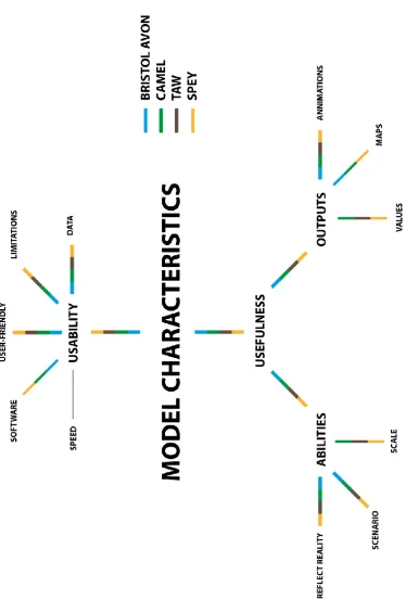
4.1.3. Model characteristics ... 113
4.1.4. Questionnaire ... 117
4.2. Conceptual model ... 129
4.3. Co-designing ... 133
4.4. Draft model ... 138
viii
4.6. Revised model ... 150
Chapter Five: The ENGAGE model ... 154
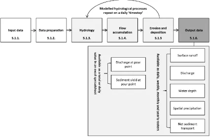
5.1. Model description ... 154
5.1.1. Input data ... 154
5.1.2. Data preparation ... 157
5.1.3. Hydrology ... 164
5.1.4. Flow accumulation ... 175
5.1.5. Erosion and deposition ... 176
5.1.6. Output data ... 184
5.2. Model assessment ... 190
5.2.1. Model use (hypothetical decision-making scenario) ... 190
5.2.2. Model comparison ... 198
5.3. Implications from the model assessment ... 211
Chapter Six: Evaluation of the participatory modelling process ... 215
6.1. The participatory modelling process and development of the model ... 215
6.1.1. The requirements analysis and the conceptual model ... 216
6.1.2. Co-designing and the draft model ... 222
6.1.3. Model demonstration and the revised model ... 225
6.2. Participatory modelling process evaluation ... 228
6.2.1. Online questionnaire ... 229
6.2.2. Follow-up interviews ... 240
6.2.3. Researcher’s reflections on the process ... 252
6.3. Implications from the participatory modelling process evaluation ... 258
6.4. A revised participatory modelling approach ... 266
Chapter Seven: Conclusions, implications, and future research ... 270
7.1. Contributions to knowledge and key findings ... 270
7.2. Implications for transdisciplinary fluvial geomorphological research and river management practitioners ... 276
7.3. Future research ... 278
Appendices ... 312
Appendix A – Requirements analysis post-session questionnaire ... 312
Appendix B - Participatory modelling process evaluation online questionnaire ... 313
Appendix C - Participatory modelling process evaluation interview topic guide ... 319
Appendix D – Model assessment of usability and usefulness. Activity 1: Questionnaire .... 321
Appendix E - Model assessment of usability and usefulness. Activity 2: Model A or Model B ... 323
Appendix F - Using ENGAGE to assist in a hypothetical decision-making process ... 325
ix
Table of figures
Figure 1-1: The research process (left) in relation to the thesis structure (right). ... 6 Figure 2-1: Breaking the paradigm lock between fluvial geomorphology and river management. Blue skies fluvial geomorphological research is shown on the left and river managers and stakeholders are shown on the right. Adapted from: Gregory (2004, p. 6). ... 24 Figure 2-2: Schematic view of different model types for simulating river systems. (a) landscape evolution; (b) reach-scale cellular automaton; (c) reach-scale CFD; (d) alluvial stratigraphy; (e) meandering. Source: Coulthard and Van De Wiel (2012, p. 2125). ... 31 Figure 2-3: Schematic of key components and processes operating within a cellular model of sediment dynamics. ... 36 Figure 2-4: The eight rungs of a ladder of citizen participation. Adapted from: Arnstein (1969, p. 217). ... 46 Figure 2-5: Davidson’s wheel of participation. Source: Heritage and Dooris (2009, p. 48) ... 47 Figure 2-6: Catchment Based Approach linkages to other groups and initiatives. Adapted from: DEFRA (2013, p. 9). ... 55 Figure 2-7: Schematic representation of the traditional ‘decide announce defend’ (DAD)
approach (A) and a participatory modelling approach to model development (B). ... 57 Figure 3-1: Conceptual diagram of the participatory modelling methodology for developing a cellular model of sediment dynamics. The numbers refer to the location within this chapter that each aspect is covered. ... 71 Figure 3-2: Conceptual diagram of the flows of knowledge in the participatory modelling process. This includes the methods used and outputs generated from each of the sessions. .. 74 Figure 3-3: Case-study river catchments. ... 79 Figure 3-4: Example of stakeholders’ notes on one of the topics for debate. ... 83 Figure 3-5: Bulls-eye diagram used by stakeholders to sort the intrinsic elements (e.g. land-use), extrinsic elements (e.g. government subsidies) and excluded factors (e.g. elements beyond the scope of this modelling). Note: The basic model elements of land cover, soil and rainfall were automatically added to the bulls-eye as without them the model would not function. ... 87 Figure 3-6: The Model website (www.engage-rivers.org.uk) which was established as a portal for stakeholders to visit to get up-to-date information on the model’s development. ... 89 Figure 3-7: Git-hub Engage model development blog located on the engage website. ... 90 Figure 3-8: The Engage model tutorials provide stakeholders with brief demonstration videos of aspects of the models operation (on ENGAGE site). ... 90 Figure 3-9: Example of the stakeholder feedback on post-it notes placed into the
corresponding theme. ... 92 Figure 3-10: Screenshots and descriptions from the participatory model demonstrations. ... 92 Figure 4-1: Overview of the methodology used in this thesis. The numbers highlighted relate to the sections in which the results are presented in this chapter. ... 102 Figure 4-2: Thematic map of sediment impacts and influences identified through the coding of the requirements analysis transcripts. The colours and thickness of the lines relate to the catchment and the number of catchments each code appears in. ... 104 Figure 4-3: Treemap of sediment impacts and influences identified through the coding of the requirements analysis transcripts. ‘Refs’ refers to the total number of times a theme was coded. ... 105 Figure 4-4: Thematic map of model applications identified through the coding of the
requirements analysis transcripts. The colours and thickness of the lines relate to the
x
Figure 4-6: Thematic map of model characteristics identified through the coding of the requirements analysis transcripts. The colours and thickness of the lines relate to the
catchment and the number of catchments each code appears in. ... 113 Figure 4-7: Treemap of the model characteristics identified through the coding of the
requirements analysis transcripts. Refs refers to the total number of times a theme was coded. ... 114 Figure 4-8: Results by catchment and combined to the question ‘How many times have you used a model in your current role in the past year?’... 118 Figure 4-9: Results by catchment and combined to the question ‘In your current role how important is it for you to understand how a model works and generates outputs?’. Note one stakeholder on the Taw did not complete this question. ... 119 Figure 4-10: Ranking of factors in order of their importance when using a model (scale of 1 (most important) to 6 (least important)). Note one stakeholder on the taw did not complete this question. ... 121 Figure 4-11: Results by catchment and combined to the question: ‘Who do you think should be responsible for running the model?’. Note that stakeholders were able to select more than one option. ... 123 Figure 4-12: Results by catchment and combined to the question: ‘Who would you consider to be the target audience for the model outputs?’. Note that stakeholders were able to select more than one option. ... 125 Figure 4-13: Results by catchment and combined to the question: ‘Which of these outputs would you consider to be useful in aiding sediment management in river catchments?’. Note stakeholders were able to select more than one option. ... 126 Figure 4-14: Conceptual model created after the requirements analysis session. ... 130 Figure 4-15: Thematic map of conceptual model feedback identified through the coding of the co-designing transcripts. ... 136 Figure 4-16: Revised Conceptual model created after the co-designing session. ... 139 Figure 4-17: Thematic map of model characteristics identified through the coding of the participatory demonstration transcripts. The colours and thickness of the lines relate to the catchment and the number of catchments each code appears in. ... 143 Figure 4-18: Treemap of model characteristics identified through the coding of the model demonstration transcripts. ‘Refs’ refers to the total number of times a theme was coded. ... 144 Figure 4-19: Revised conceptual model created after the model demonstration session. ... 150 Figure 5-1: Overall model structure and the sections in which they are covered in this chapter for the six stages of the models operation. ... 154 Figure 5-2: Input data for the ENGAGE model. ... 155 Figure 5-3: Data preparation tools for the ENGAGE model and the order in which they are run. *Note only stage 2 and 3 are required to run the model. the others are optional processes. 157 Figure 5-4: Example of the ENGAGE interface within ArcGIS 10.2.2. On the left is the ENGAGE folder structure viewed from ArcCatalog. On the right is the raw data processing script
interface. ... 158 Figure 5-5: Schematic representation of the merge raster tiles aspect of the data preparation stage. ... 159 Figure 5-6: Schematic representation of the burn in river channel aspect of the data
xi
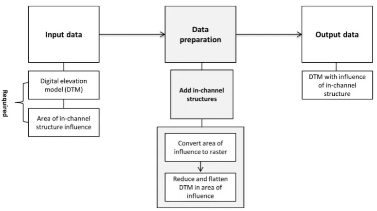
Figure 5-9: Schematic representation of the add in-channel barrier aspect of the data
preparation stage. ... 162
Figure 5-10: Schematic representation of the alter precipitation aspect of the data preparation stage. ... 162
Figure 5-11: Schematic representation of the alter land cover aspect of the data preparation stage. ... 163
Figure 5-12: Schematic representation of the baseflow calculation aspect of the data preparation stage. ... 164
Figure 5-13: Hydrology processes in ENGAGE model and the order in which they are run. *Note that stage 4 is an optional requirement. ... 165
Figure 5-14: Schematic representation of the process for calculating precipitation in the hydrology stage. ... 167
Figure 5-15: Schematic representation of the process for calculating evapotranspiration in the hydrology stage. ... 168
Figure 5-16: Schematic representation of the process for calculating surface runoff in the hydrology stage. ... 170
Figure 5-17: Schematic representation of the process for calculating baseflow in the hydrology stage. ... 175
Figure 5-18: Flow accumulation processes in the ENGAGE model. ... 175
Figure 5-19: Schematic representation of the process for calculating discharge in the flow accumulation stage. ... 176
Figure 5-20: Erosion and deposition processes in ENGAGE model and the order in which they are run. ... 177
Figure 5-21: Schematic representation of the process for calculating hillslope sediment using the MULSE. ... 179
Figure 5-22: Schematic representation of the process for calculating the sediment timestep in the erosion and deposition stage. ... 180
Figure 5-23: Schematic representation of the process for calculating the Active and inactive layer depth in the erosion and deposition stage. ... 181
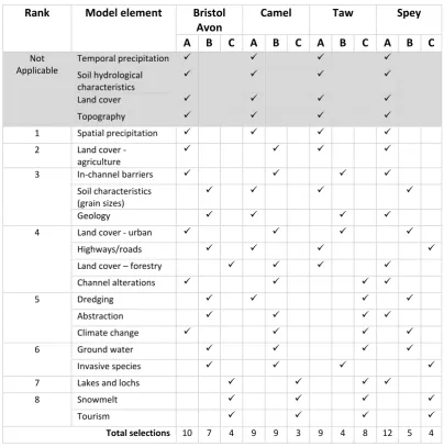
Figure 5-24: Schematic representation of the process for calculating net sediment transport in the erosion and deposition stage. ... 182
Figure 5-25: Schematic representation of the process for calculating elevation adjustment in the erosion and deposition stage. ... 183
Figure 5-26: Schematic representation of the process for calculating mass wasting. ... 184
Figure 5-27: Output data from the ENGAGE model. ... 185
Figure 5-28: Example input data for the hypothetical decision-making scenario ... 186
Figure 5-29: Example hydrology monthly total outputs from the hypothetical decision-making scenario prior to land cover changes being made ... 187
Figure 5-30: Example in-channel net sediment transport monthly total from the hypothetical decision-making scenario prior to land cover changes being made ... 188
Figure 5-31: Parcel of land cover changed from pasture to broadleaf woodland during the hypothetical decision-making scenario ... 189
Figure 5-32: Change in surface runoff and net sediment transport following the change of land cover type in the hypothetical decision-making scenario. ... 189
Figure 5-33: Thematic map of themes and sub-themes identified through the coding of the hypothetical decision making scenario transcripts. The colours and thickness of the lines relate to the catchment and the number of catchments each code appears in. ... 191
xii
xiii
Table of tables
Table 2-1: Attributes of fluvial geomorphological systems important for generating or
contributing to ecosystem services. Source: (Everard and Quinn, 2015, p. 492). ... 12 Table 2-2: Quality elements for the classification of ecological status in rivers under the Water Framework Directive (WFD). Source: Newson and Large (2006, p.1609). ... 14 Table 2-3: Some examples of methods of communication between geomorphologists and river management practitioners identified in Gregory et al. (2008, p.161-162). ... 25 Table 2-4: Sample of catchment-scale landscape evolution models developed from the 1980’s onwards. ... 33 Table 2-5: Summary of the main benefits of using participatory approaches split into normative and pragmatic claims. ... 43 Table 2-6: Typologies of participation. Source: Reed (2008, p. 2419) ... 45 Table 2-7: Summary of main participatory modelling approaches. ... 58 Table 2-8: Participatory modelling challenges identified through the review of the literature. 61 Table 2-9: Comparison of frameworks for categorising participatory modelling processes. Source: Hare (2011, p.388) ... 62 Table 2-10: Summary of Hare’s (2011) Participatory modelling framework ... 63 Table 3-1: The participatory methodology adopted in this research situated within Hare’s (2011) participatory modelling framework. ... 72 Table 3-2: Breakdown of the roles and organisations of each stakeholder who were present in each participatory modelling session. ... 80 Table 3-3: Participatory modelling challenges identified through the review of the literature and the solutions implemented in this methodology. ... 99 Table 4-1: Results from a Kruskal-Wallis H test to the questions ‘How many times have you used a model in your current role in the past year?’ and ‘In your current role how important is it for you to understand how a model works and generates outputs?’. ... 120 Table 4-2: Themes, sub-themes and elements emerging from the analysis of the requirements analysis data. ... 128 Table 4-3: Summary of the stakeholder requirements, whether they were incorporated into the conceptual model, the justification behind this decision, and the method of inclusion or consideration. The shaded areas are those prioritised in the co-designing session. ... 131 Table 4-4: Results from each catchment using the bulls-eye diagram to rank model elements. This is ranked based on the position of each element in the bulls-eye activity for each group. Where: A – Intrinsic, B – Extrinsic and C – Excluded. Note that the top four shaded rows were identified to stakeholders as intrinsic to developing the model and therefore stakeholders were not required to prioritise these model elements. ... 134 Table 4-5: Results of the ranking exercise of the potential model applications. ... 135 Table 4-6: Summary of the stakeholder requirements, whether they were incorporated into the draft model, the justification behind this decision, and the method of inclusion or
consideration. The shaded areas are unchanged from the conceptual model. ... 140 Table 4-7: Summary of the stakeholder requirements, whether they were incorporated into the revised model, the justification behind this decision, and the method of inclusion or
xiv
Table 5-4: Descriptive and statistical (Kruskal-Wallis H test) analysis of the data collected in the model comparison exercise where stakeholders were asked to: ‘Please rank the following model characteristic from the most important (1) to the least important (10)’. ... 201 Table 5-5: Results for the incorrectly completed forms in the model comparison exercise where stakeholders were asked to ‘Please rank the following model characteristic from the most important (1) to the least important (10)’. ... 205 Table 5-6: Results from the model comparison exercise where stakeholders were asked to provide “a rating out of 10 (High) below for each model in relation to the likelihood that you would use in your day job if you had a need to conduct an investigation that required the use of a sediment dynamics model or as part of a decision making process”. ... 208 Table 6-1: Summary of the relationship between the literature, reduced-complexity cellular models, and the human and natural influences described by the stakeholders in the
1
Chapter One:
Introduction
1.1.
Context setting
‘As population increases and the pressure on Earth resources grows, the
competition for water, timber, open space, fuels, and environmental desires
will bring a need for more knowledge and more data on the processes and
the factors in geomorphology. Its importance to both science and to daily
life can only increase.’
(Leopold, 2004, p.10)
2
This debate is developed by reflecting upon the current and future importance of fluvial geomorphology and sediment dynamics modelling, to river catchment management in the United Kingdom. This research explores the recognition of fluvial geomorphology (under ‘hydromorphology’) in the European Unions’ (EU) Water Framework Directive (WFD) (2000/60/EC), and the benefits this can bring to ensuring the sustainable management of river catchments. In particular, the research identifies the potential uses of sediment dynamics models to improve river management, and discusses their limited uptake to date. Following this, the research critically reviews the social science of participation and identifies a participatory approach to developing models referred to as participatory modelling (PM). PM is suggested to increase the uptake of research developed models by practitioners as the process can increase model quality, acceptance, and integration into existing stakeholder systems and processes (Borowski and Hare, 2007; Barreteau et al., 2010).
In its analysis of existing literature and new empirical data, this research describes and evaluates a new transdisciplinary approach to developing a cellular model of sediment dynamics through the involvement of stakeholders in a PM process, which to date has not been applied in the discipline. This process was delivered through co-working with four river catchment stakeholder groups across the United Kingdom.
1.2.
Aims and objectives
The aim of this thesis is to establish, implement and critically analyse a participatory modelling approach for developing and evaluating a catchment-scale cellular model of sediment dynamics. This model should be usable by management stakeholders engaging in decision-making for sustainable river catchment management. From this aim, the following objectives are derived:
1. Identify and situate the importance of sediment dynamics to sustainable river
catchment management, and evaluate existing approaches to modelling of
3
2. Investigate existing approaches to stakeholder engagement and participation in
modelling, with a particular focus on those used within environmental management;
3. Assemble and describe a new participatory modelling approach to developing a
catchment-scale cellular model of sediment dynamics;
A. Use the new participatory modelling approach to identify, refine and prioritise
the requirements of management stakeholders when creating and using a
catchment-scale sediment dynamics model in river catchment management;
B. Use the new participatory modelling approach to assemble and describe a new
model of river catchment sediment dynamics;
4. Critically evaluate the developed participatory modelling approach as a methodology
for:
A. Engaging with stakeholders in model development to reduce the number of
unused research models, improve model quality, acceptance of the model, and
integration of the model with stakeholder management processes;
B. Promoting knowledge exchange and social learning between fluvial
geomorphologists and river management practitioners;
5. Critically assess the new cellular model as a tool for use within river management.
6. Propose a refined participatory modelling approach based on the results from the
process evaluation and model assessment.
1.3. Research process and structure
The overall research process and structure of the thesis is shown in Figure 1-1.
4
Chapter Two contextualises the research by exploring the academic and professional literature. In particular, the importance of fluvial geomorphology to river management in terms of ecological status and flood risk, as well as its representation in legislation and policy. Once this has been established, this chapter moves on to describe how fluvial geomorphology needs to become part of an integrated interdisciplinary river science, creating the knowledge and tools that river managers and practitioners require. Following this, a recognised challenge facing the discipline of limited knowledge exchange between fluvial geomorphologists and river management practitioners is described. An example is highlighted in the development and practical application of reduced complexity cellular sediment dynamic models. Finally, Chapter Two reviews and analyses the potential role of participation as a solution to the challenges described in the previous sections. In doing so, this chapter examines a participatory approach to developing models, termed participatory modelling.
Chapter Three describes the development of a new participatory modelling approach to developing a cellular model of sediment dynamics. This begins with a discussion of the over-arching research strategy and theoretical rationale. Next, the justification behind the use of a fundamental modelling structure within this approach is presented. Following this, the developed participatory modelling process is described in detail. This comprises of an explanation of the criteria used to select the stakeholder groups and case study catchments, as well as description of each of the participatory sessions. Next, the chapter presents the methodology used for evaluating the participatory modelling process with the stakeholders. The final section presents the methods for assessing the developed model in relation to its usability and usefulness as a tool for use within river management.
5
chapter moves on to outline and discuss the results from the assessment of the developed model as a tool for use by river managers.
Chapter Six develops a discussion by critically reflecting on how the results relate to the aim and objectives, as well as how the knowledge generated is situated within the literature. This is achieved by discussing the findings at each stage of the participatory modelling process, and the development of the model. Following this, the chapter presents and then discusses the results from the evaluation of the process with the stakeholders. This includes the researchers’ reflections on the methodology which identify a number of methodological considerations and recommendations for future research. Finally, the last section proposes and discusses a revised participatory modelling approach.
6
7
Chapter Two:
Literature review
This chapter explores the international academic and professional debates within literature relating to fluvial geomorphology and participation in order to provide the context for this transdisciplinary research project. To achieve this, four key themes will be critically examined in this chapter:
The importance of fluvial geomorphology to river management (Objective 1);
Modelling of river catchment sediment dynamics (Objective 1);
Participation and environmental management (Objective 2);
Participatory modelling (Objective 2).
In doing so, this chapter identifies a knowledge gap in the use of participatory modelling to promote knowledge exchange and increase the practical application of sediment dynamics models by river management practitioners.
2.1.
The importance of fluvial geomorphology to river catchment management
2.1.1.
Introduction to fluvial geomorphology
8
‘…the study of sediment sources, fluxes and storage within the river
catchment and channel over short, medium and longer timescales and of
the resultant channel and floodplain morphology.’
(Sear et al., 2004, p. 2)
River management practitioners have realised the importance of fluvial geomorphology since the beginning of the 20th century, at which point, it was thought that practical demands of the mining industry were responsible for the formation of fluvial geomorphology as a recognised science. One of the earliest examples of fluvial geomorphological analysis dates back to the 8th December 1904. Clifford (2008) describes how the California Miners’ Association petitioned President Roosevelt to investigate erosion and sedimentation in the Sacramento and San Joaquin valleys, where, in 1884, restraints had been placed on the discharge of material into navigable waterways due to complaints from local farmers concerned about river instability and flooding. This resulted in the shutting down of the hydraulic mining industry in the area and an estimated $100,000,000 property was left idle (Clifford, 2008). Geologist Karl Grove Gilbert (1917) studied the delivery of sediment from hydraulic mining and discovered that the river had adjusted to the increased sediment supply, arguing in favour of the miners. Gilbert is now considered to be one of the founders of fluvial geomorphological science. At the same time, throughout Europe, the practical need to understand how sediment influenced channel flows and geometry propelled fluvial geomorphological science forward. This was particularly driven by colonial canal engineers in India and Pakistan who formulated and refined ‘regime theory’ in alluvial channels (Clifford, 2008). The engineers used their practical experience to inform their theories, including the realisation that channel slope and shape significantly influenced channel bank stability and sediment transfer in canal systems.
9
et al., 2013; Lewin and Macklin, 2014). For example, soil erosion has increased globally as a result of
intensification of agriculture (Hoffmann et al., 2015), mining (Wantzen and Mol, 2013), forestry (Borrelli et al., 2015), and urbanisation (Whitney et al., 2015). Estimates suggest that in parts of the world, humans are responsible for displacing more soil than is being produced by an order of several magnitudes (Montgomery, 2007). Haff (2010) suggests that rivers are the only land-based geomorphic system that moves more sediment than human technological ‘mass-wasting’. Similarly, Syvitski et al. (2005) estimate that humans are responsible for an increase in annual global sediment transport by rivers (2.3 ± 0.6 billion metric tons). However, the quantity reaching the oceans has decreased due to impoundments and associated reservoir trapping (4 ± 0.3 billion metric tons).
Anthropogenically induced climate change is likely to exacerbate natural mass-wasting and sediment transport through the intensification of the hydrological response of river catchments (Lane et al., 2007). However, as Lane et al. (2007) recognise, predicting this response and subsequent impacts are difficult due to the complexity and non-linearity of the system. Geomorphological research is beginning to recognise this, and subsequently a wealth of new research on this topic has emerged (e.g. Bauch and Hickin, 2011; Foulds et al., 2014; Lu et al., 2010; Praskievicz, 2015). On the other hand, Lane (2012) poses the question ‘Where has all the geomorphology gone’ in respect to the limited reference made to geomorphology in the IPCC Fourth Assessment Report (2007). Furthermore, a review of the Fifth Assessment Report (2014) suggests little has changed, with only 5 direct references.
From the late 20th century, fluvial geomorphology has been moving towards a new methodology of practical application of knowledge in the context of river management (Sear et al., 1994; Thorne et
al., 1997; Downs and Gregory, 2004; Rinaldi et al., 2013). Fluvial geomorphology is now partially
10
1. the financial and environmental costs of ignoring natural system processes (Evans et
al., 2004). For example, in 2012/13 the Environment Agency (EA) spent £45 million on
channel maintenance, some of which may have been avoided with better
environmental stewardship (Environment Agency, 2014);
2. increasing recognition that catchment management decisions are influenced by and
impact on sediment transport and storage (Lane and Thorne, 2006). For example,
instream structures such as dams (see: Jones and Parker, 2015) and changes to
catchment characteristics through land use change (see: McIntyre and Thorne, 2013).
DEFRA estimates soil degradation and the resultant impacts (e.g. flooding) costs the UK
£0.2 billion–£0.3 billion per year (DEFRA, 2009); and
3. an evolution in the way river systems are treated, with the traditional approach of river
engineering changing to river management (Williams, 2001), and the replacement of
hard engineering by more adaptive ‘softer’ engineering approaches (Brierley and Fryirs,
2005; Downs and Gregory, 2004). Recently, natural flood management (Pearson et al.,
2015; Wilkinson et al., 2014) has been rising up the UK political agenda as a result of
the flooding in 2013/14 on the Somerset Levels and the winter floods of 2015/16 in
Cumbria (e.g. articles in the Guardian (Anon., 2016) and Independent (Lean, 2016)).
11
2.1.2.
Fluvial geomorphology and management of the ecological status of
river channels
Fluvial geomorphology is important to the biodiversity of rivers as, globally, the fluvial sediment system determines the habitat of approximately 175,000 species of animals and plants (Palmer et
al., 1997). The management of the ecological status of river channels can benefit from fluvial
geomorphological input due to the close connectivity and interactions between ecological, hydrological and geomorphological systems (Sear et al., 2004; Croke et al., 2013), referred to as ecohydromorphology (Vaughan et al., 2009). This is reinforced by Table 2-1 from Everard and Quinn (2015) who build upon Bergeron and Eyquem’s (2012) work on identifying the relationships between geomorphological systems and ecosystem services.
12
TABLE 2-1: ATTRIBUTES OF FLUVIAL GEOMORPHOLOGICAL SYSTEMS IMPORTANT FOR GENERATING OR CONTRIBUTING TO ECOSYSTEM SERVICES.SOURCE:(EVERARD AND QUINN,2015, P.492).
Attribute Description
Water quantity (amount of flow)
Channel flow is a defining feature of fluvial systems, from which society derives the significant benefit of water supply
Water delivery (timing of flow)
Fluvial geomorphology and catchment-scale geomorphological and hydrological processes play key roles in determining the timing of flow, including ameliorating flood impacts by attenuation and supplying baseflow during droughts
Water quality Physical
Fluvial geomorphological processes determine water velocity, turbulence,
temperature, conductivity and clarity (suspended sediment), all of which
influence other ecosystem processes, directly or indirectly contributing to various ecosystems services
Chemical
Processes occurring in the fluvial environment contribute to maintaining
dissolved oxygen as well as the chemical character and odour of river water Biological
Fluvial geomorphological processes involving the interaction of water and sediment with channel morphology generate a diversity of habitats supporting microorganisms, plants, invertebrates, fish, wildlife and their associated genetic diversity, all contributing to ecosystem health or biotic
integrity
Sediment characteristics Suspended sediment load
Fluvial geomorphological processes determine the size fraction, amount and
timing of erosional and transport processes, influencing primary production in
the water column and the redistribution of sediment in the watercourse and floodplain
Bed substrate
Fluvial geomorphological processes determine the bed material size, amount,
distribution and form (bars and bedforms) determining the nature of benthic
habitat, influencing the characteristics of water flowing over it Morphological
characteristics
Channel and floodplain morphology
Fluvial geomorphological processes determine the channel gradient,
dimensions, form, pattern, and associated depositional (e.g. point bar,
floodplain) and erosional (e.g. cut bank) features: key attributes of the template of a river valley providing the physical basis for habitat and associated ecosystem services
Bed stability
Characteristics of the bed substrate, together with flow conditions and sediment load, determine bed stability
Bank stability
Characteristics of the bank, together with flow conditions and sediment load, determine bank stability
(USED WITH PERMISSION OF TAYLOR &FRANCIS)
13
fine sedimentation leading to higher egg mortality rates. River channelization has been found to significantly reduce the diversity and abundance of species due to significant changes in the natural sediment dynamics of the system (Brookes, 1985; Oswalt and King, 2005). Furthermore, processes such as dredging and de-snagging remove important geomorphic features such as pools, riffles and bars, and disturb the bed sediment as a result of higher velocities and stream power (Downs and Gregory, 2004). This was shown in a study of the extractive industries on the Hawkesbury-Nepean River in New South Wales, Australia where these processes significantly impacted on the biological environment, resulting in the loss of macrophytes and riparian vegetation, weed invasion, fish kills and reduced diversity of aquatic habitat (Erskine, 1998). More recently, a study on the impacts of a hydropower damming in the Mekong River Basin through an ecological network analysis found an initial 30% cumulative impact, with species at the top of the food chain significantly more impacted (e.g. mollusca, benthic-feeding fish and zooplanktivorous fish) (Chen et al., 2015).
The significance of fluvial geomorphology to the ecology of river systems is now recognised, to a degree, in policy and legislation (Newson and Large, 2006). In particular, the Water Framework Directive (WFD) (2000/60/EC) set a target for all waters in Europe to achieve a ‘good ecological status’ or ‘good ecological potential’ for heavily modified waterbodies by 2027. In the spatio-temporal assessment of compliance with the regulations of the WFD, fluvial geomorphology (referred to under ‘hydromorphology’) is now recognised as a supporting parameter (Table 2-2) for ecosystems (e.g. appropriate spawning and breeding habitat (Borja and Elliott, 2007)) and engineering (e.g. scour at bridges and hydraulic structures (May et al., 2002)). Planning and progression for the WFD continues in 6 year cycles of developing and implementing River Basin Management Plans (RBMPs) until 2027. Initial reports suggest that the EA will soon release figures stating that only 17% of rivers in England and Wales will achieve good ecological status in 2015 (Harrabin, 2015).
Over the past 15 years, a significant amount of research and progress has been made in respect to: (i) the assessment and monitoring of hydromorphological condition (e.g. Allan et al., 2006; Rowan et
14
restoration measures (for a review see: Kail et al., 2016). Despite this, there are still knowledge gaps that will need to be addressed in order to be able to utilise the insights from hydromorphology effectively to achieve ‘good ecological status’. Vaughan et al. (2009), Death et al. (2015), and Everard and Quinn (2015) provide detailed analysis and description of these knowledge gaps. Two emergent themes from these reviews are of relevance to this thesis. Firstly, the requirement to develop practically applicable eco-hydromorphological models and tools to assist practitioners in decision-making processes. Secondly, there is an ever greater requirement for truly interdisciplinary research through the breakdown of traditional disciplinary barriers to develop greater understanding of, and be able to model eco-hydromorphological relationships. These two key themes are explored in greater depths later in this chapter (Sections 2.1.4 and 2.2).
TABLE 2-2:QUALITY ELEMENTS FOR THE CLASSIFICATION OF ECOLOGICAL STATUS IN RIVERS UNDER THE WATER FRAMEWORK DIRECTIVE (WFD).SOURCE:NEWSON AND LARGE (2006, P.1609).
(USED WITH PERMISSION OF JOHN WILEY &SONS)
Quality element Description
Biological elements Composition and abundance of aquatic flora
Composition and abundance of benthic invertebrate fauna
Composition, abundance and age structure of fish fauna
Hydromorphological elements supporting the biological elements
Hydrological regime
Quantity and dynamics of water flow Connection to groundwater bodies River continuity
Morphological conditions River depth and width variation Structure and substrate of the river bed Structure of the riparian zone
Chemical and physico-chemical elements supporting the biological elements
Thermal conditions Oxygenation conditions Salinity
Acidification status Nutrient conditions Specific pollutants
Pollution by all priority substances identified as being discharged into the body of water
15
In addition to the WFD, there are several other policy drivers influencing the practical application of fluvial geomorphology to the management of riverine ecology in the UK and Europe, including: United Kingdom Biodiversity Action Plans (BAPs), European Habitats Directive (92/43/EEC), Freshwater Fisheries Directive (2006/44/EC), Wildlife and Countryside Act (WCA) and Natural Heritage (Scotland) Act. Additionally, the Environment Agency (EA) and Scottish Environmental Protection Agency (SEPA) have a number of corporate targets, responsibilities and works that require fluvial geomorphological input, such as habitat protection (Sear et al., 2004). Compliance with WFD regulations and other policy drivers, has and will in future require river management to be informed by research in fluvial geomorphology (Eyquem, 2007).
2.1.3.
Fluvial geomorphology and the management of flood risk
16
management is exemplified in a recent study by Slater et al. (2015) who observed significant changes in flood hazards as a result of natural changes to channel capacity, which is often assumed to be static in the design of flood defences.
There are several important contributions that fluvial geomorphologists can make to improve flood risk management, these are:
To demonstrate the interconnectivity of the fluvial system and the complex dynamic
system of positive and negative feedbacks that exist between river planform, profile,
and cross-section (Ashworth and Ferguson, 1986);
To emphasise the importance of treating fluvial systems as a physical system with a
history, recognising the importance of spatio-temporal scales over which
geomorphological processes operate (Schumm, 1977);
To highlight the sensitivity of the fluvial systems to change through the concepts of
‘threshold behaviour’ and ‘complex response’, as well as promoting the existence of
non-linearity in the relationship between channel form and geomorphic processes
(Lane and Richards, 1997). Additionally, recognising the importance of understanding
eco-hydromorphology as an approach to achieving ecologically acceptable engineering
(Vaughan et al., 2009);
To use the above knowledge to provide recommendations sensitive to how
management practices (e.g. dredging and desnagging) may impact upon flood
conveyance and suggest solutions to resolve or reduce issues surrounding channel
instability (e.g. river bank erosion) (for a review see: Gregory et al., 2008).
17
results from the study indicate that coarse sediment aggradation was responsible for around 50% of the inundation extent increase expected from climate change for the same event in 2050. A number of limitations are associated with the use of this approach, such as the sediment sensors only covering a small part of the active channel and uncertainties in climate change scenarios (Lane et al., 2007). Additionally, this approach is extremely time-consuming, requiring significant amounts of technology and expertise. As a result, applying this approach on a whole river system or at a large scale is not easily achievable or cost-effective. Models of catchment-scale sediment dynamics could be a way of overcoming some of these limitations. Arnaud-Fassetta et al. (2009, p. 124) recognised this, stating that:
‘Modelling should be an essential tool for re-learning to live with rivers and
fluvial changes, accepting and understanding floodplain processes and the
wider environment in which societies choose to live.’
The potential of these models to contribute to flood risk management will be explored later in Section 2.2.
18
However, this approach requires a significant amount of data (e.g. historical and field data) and resources (e.g. manpower and expertise) therefore, to date, only a small number of hydrogeomorphological maps of important sections of rivers in France have been created (Arnaud-Fassetta et al., 2009; Montané et al., 2015).
Effectively managing future flood risk and preventing further damage to flood defence infrastructure will require the practical application of fluvial geomorphological knowledge to be reflected in legislation. In England and Wales, Catchment Flood Management Plans (CFMPs) and River Basin Management Plans (RBMPs) have been established in the last decade (Wilby et al., 2006), requiring fluvial geomorphological assessments to be conducted to understand the processes at work (Evans
et al., 2002). These assessments entail understanding of how sediment dynamics and channel
evolution vary across a catchment, as well as the close interrelationships that exist between fluvial geomorphology, hydrology, ecology and geology (Eyquem, 2007). However, the production of the next phase of Flood Risk Management Plans (FRMPs) required by the EU Floods Directive (2007/60/EC), does not include a direct geomorphological assessment, and only a single reference is made to geomorphology as an ‘environmental objective’ in the guidance (DEFRA, 2014b).
2.1.4.
The role of interdisciplinarity in fluvial geomorphology’s contribution
to river management
19
promotes environmental and societal benefits (Harris and Lyon, 2013). The role of interdisciplinarity in fluvial geomorphology’s contribution to river management will be explored in this section.
One of the most widely recognised and cited definitions of interdisciplinary research (Repko et al., 2013) was issued jointly by The National Academy of Sciences, the National Academy of Engineering, and the Institute of Medicine in the USA (2005, p. 26):
‘a mode of research by teams or individuals that integrates information,
data, techniques, tools, perspectives, concepts, and/or theories from two or
more disciplines or bodies of specialized knowledge to advance
fundamental understanding or to solve problems whose solutions are
beyond the scope of a single discipline or area of research practice.’
Sear et al. (2004, p.4) recognised the importance of interdisciplinarity when applying fluvial geomorphology in river management, arguing that the fundamental philosophy should be:
‘…to understand, through interdisciplinary science, the causes of river
management problems arising from river channel sediment transport
processes, and to consider the implications of any proposed activity to
address the problem on the local and regional sediment system.’
20
(Hillman, 2009; Rice et al., 2010). This is in part due to the current nature of science and interdisciplinary research requiring a change in the current processes of knowledge creation and dissemination. The main reasons for limited interdisciplinary research in general terms (beyond fluvial geomorphology) are suggested to be:
Communication – the time required to learn and understand the vocabulary, theory
and methodologies of other disciplines (Boulton et al., 2008);
Incentives – institutional reward and timescales of publication due to personal styles
and locations, although Sievanen et al. (2012) suggest recently there has been a shift
towards funding and recognition of the value of this type of research in ecosystem
based approaches;
Frameworks and processes – the challenge of incorporating social and political
knowledge into the positivist scientific form (Campbell, 2005);
Loss of the single discipline mastery due to the commitment and time to learn other
disciplines, resulting in a perception that interdisciplinary researchers are less
competent (Naiman, 1999).
This is also reflected in the way in which hydrology, geomorphology and ecology interact, as each discipline has its own methodological approach and perspective. Therefore to date, these disciplines have tended to operate in ‘a parallel, multidisciplinary mode rather than in an integrated, interdisciplinary mode to address questions of mutual scientific interest’ (Rice et al., 2010, p. 65).
21
different river research fields are not strongly connected in terms of knowledge exchange’ and that ‘river science has not (yet) emerged as an interdisciplinary research field’.
Researchers in hydrology, geomorphology and ecology over the past decade have begun to emphasise the requirement for interdisciplinary collaboration under the term ‘ecohydromorphology’ to understand the complex temporal and spatial relationships between ecological and physical habitats (e.g. Vaughan et al., 2009; Meitzen et al., 2013; Kohlhagen et al., 2013). However, as Vugteveen et al. (2014) identify, the use of this new approach is yet to materialise in published research. In this thesis, a detailed review of the literature yields one potential ecohydromorphological study (although the study does not use the term). In this study, Freidman et
al. (2014) investigated the impact of the degradation of peatlands in Australia’s Blue Mountains by
human activities on the geomorphic processes, and ecological and hydrological services. The study identified key indicators for geomorphic processes (e.g. peat formation) to help inform the conservation and management of the peat swamps for ecological and hydrological services.
Some researchers go further and argue that future partnerships must be formed between not just the hydrologists, ecologists and geomorphologists but also engineers and social scientists (Palmer and Bernhardt, 2006; Pahl-Wostl et al., 2007; Hillman, 2009). Palmer and Bernhardt describe the integration with social science as the ‘final frontier’ suggesting that few, if any river restoration studies have involved integration with social science. Vugteveen et al. (2014) support this, finding few citations to social science literature from the traditional natural science journals (with the exception of Water Resources). However, Vugteveen et al.’s (2014) investigation could be more convincing if newer interdisciplinary and open-access journals had been included in their analysis as publishing interdisciplinary research can be difficult in traditional journals (Miller et al., 2008).
22
influenced by the values and beliefs of different groups within society (e.g. the planners, managers, and citizens). Therefore, if scientists and planners understand the needs and values of stakeholders, they can develop solutions that better balance social and environmental needs.
The following is clear from the previous sections: (i) fluvial geomorphology has developed significantly as a discipline over the past century; (ii) fluvial geomorphology is an important consideration in the management of river catchments (especially from ecology and flood risk perspectives); and (iii) a new agenda of interdisciplinary working with other disciplines including the social sciences is emerging. Despite this, there are still very few direct references to fluvial geomorphology in policy and legislation, which could be the result of the disconnect between fluvial geomorphological research and the ‘take-up’ of practical applications by river management practitioners.
2.1.5.
The importance of knowledge exchange in pro moting fluvial
geomorphology’s contribution to river management
Despite increased recognition of the importance of fluvial geomorphology to sustainable river catchment management, Sear et al. (2004) suggest that river management practitioners have only begun to recognise the need for specialist input from fluvial geomorphology. Gregory (2004) first recognised this as an issue, arguing that limited knowledge exchange is occurring between the ‘blue skies’ scientific researchers and river management practitioners and stakeholders. Newson and Large (2006) also recognise this, suggesting that to achieve ‘good ecological status’ requires increased knowledge exchange between researchers and practitioners (Newson and Large, 2006). Gregory et
al. (2008) proposed that a paradigm lock (Figure 2-1 – Current situation) exists as the ‘blue skies’
23
cannot be expected to be aware of all the detailed science published in books and papers, as there are often issues with accessibility and resource requirements.
24
Current situation
Ideal future situation
25
TABLE 2-3: SOME EXAMPLES OF METHODS OF COMMUNICATION BETWEEN GEOMORPHOLOGISTS AND RIVER MANAGEMENT PRACTITIONERS IDENTIFIED IN GREGORY ET AL.(2008, P.161-162).
Method of
communication Description Example Potential issues
Papers
Research papers with potential for application
Proposal of scheme for urban catchment management plan
(Gregory, 2002)
Accessibility – cost to access journals
and level of technical knowledge
required to understand (e.g.
terminology)
Passive engagement method – requires
practitioner to actively search, understand, and apply knowledge to
management practices
Traditional type of communication – does not target ‘millennial’ river management practitioners Review papers identifying potential applications
Integrating geomorphological tools in ecological and management studies
(Kondolf et al., 2003)
Applied research papers submitted to non-academic journals
Solving an urban river erosion problem on the Tilmore Brook, Hampshire (UK)
(Brookes et al., 2005)
Books / Book chapters
Book or chapters in volume on specific subject intended to
include readership beyond the discipline
Geomorphology for engineers (Fookes, 2005)
Accessibility – cost to access textbooks
and level of technical knowledge
required to understand (e.g.
terminology)
Passive engagement method – requires
practitioner to actively search, understand, and apply knowledge to
management practices
Traditional type of communication – does not target ‘millennial’ river management
practitioners
Management organisations do not
have central libraries or repositories for textbooks (in the authors experience) Book of edited
contributions intended to include readership beyond the discipline
Applied Fluvial Geomorphology for River Engineering and Management
(Thorne et al., 1997)
Reports
Contracted to outline the state-of-the-art in
application
Guidebook of Applied Fluvial Geomorphology: R and D Technical
Report FD1914 (Sear et al., 2004)
Passive engagement method – requires
26
A recent example of a communication failure between scientists, river management practitioners, and the public occurred during the winter 2013/14 floods on the Somerset Levels in South West England, during which over 16,000 acres of land and approximately 40 properties flooded (McEwen
et al., 2014; Hannaford et al., 2014). This was the result of ‘an exceptional run of winter storms’ actively search, understand, and apply knowledge to
management practices
Traditional type of communication –
does not target ‘millennial’ river management practitioners Educational outreach Geomorphologists participation in non-geomorphology
conferences
Attending and contributing to multidisciplinary and other discipline
conferences e.g. ASCE, restoration-based conferences
Accessibility – cost /time required to attend and level of technical knowledge required to understand (e.g. terminology) Assumption that river management practitioners will attend other disciplinary conferences or geomorphology workshops Passive engagement method – requires
practitioner to actively search for conference, attend,
understand, and apply knowledge to
management practices
Traditional type of communication –
does not target ‘millennial’ river management
practitioners
Geomorphology-centred workshop to inform state-of-the-art
beyond the discipline
ESF LESC workshop on large wood in European Rivers: dynamics, human perception, challenge for restoration and application to other areas (Piégay
and Gregory, 2005)
Geomorphology shortcourses/training
Principles and practice of stream restoration and geomorphology and sediment transport in channel design channel classification course. Utah
State University Department of Aquatic, Watershed, and Earth Resources courses (Rosgen and Silvey,
1996)
Geomorphology contributions to public
education
Flood education and flood perception (Benito and Thorndycraft, 2004)
Other Chartered status
Chartered geographer (C.Geog Geomorph)
27
(Slingo et al., 2014, p. 3). The politics of public opinion and pressure from local residents overrode the overwhelming scientific and practitioner opinion that channel maintenance through dredging would have a limited effect (CIWEM, 2014). In fact, Thorne (2014, p. 301) explains that dredging ‘fails
to treat the cause of the problem, which simply recurs in a few months or years as sediment supplied
from the catchment again accumulates in the channel.’. In March 2014, in order to show that the
government was ‘doing something’, a new five million pound dredging scheme to remove the silt that has built up along the banks of the rivers Parrett and Tone was approved (Morris, 2014). The researcher considers this to be an example of knowledge exchange failure as river management practitioners understood through modelling, cost-benefit analysis, and environmental analysis that dredging would have little long term effect on flood risk (CIWEM, 2014). However, this knowledge was not adequately communicated to the general public or politicians. Therefore, when pushed by politicians and members of the public as to why dredging did not take place, the EA needed to be able to effectively communicate the hydrological, ecological, and geomorphological evidence behind the decision.
At this point it is important to introduce the concept of transdisciplinary research, which encapsulates the two themes (interdisciplinary research and knowledge exchange) discussed in the current and the previous section. Mollinga (2009, p. S199) defines transdisciplinary research as:
‘…interdisciplinary research that is strongly embedded in the problem
context. In transdisciplinary research so-called ‘stakeholders’ (interest
groups) are intimately involved in research formulation and
implementation, affecting the way “science is done” deeply ... It is often
“participatory” in nature, with strong understandings of participation
implied’.
decision-28
making processes are involved (Pohl and Hadorn, 2007). Funtowicz and Ravetz (1995) propose that engaging with stakeholders through transdisciplinary research can shape research agendas and provide new types of data. As a result, adopting transdisciplinary research approaches could play a pivotal role in assisting fluvial geomorphologists promote knowledge exchange about complex and disputed issues relating to the management of river catchment sediment dynamics. However, the transdisciplinary research approach raises the same challenges as interdisciplinary research (e.g. differing terminologies, methods, conceptual challenges), and raises additional questions about the incentives for collaboration, and how trust is created between stakeholders and researchers (Harris and Lyon, 2013). Transdisciplinary research is suggested to originate from ‘post-normal science’, an epistemological approach which shifts away from the way in which traditional science is conducted in ignorance of methodological, societal and ethical impacts (Funtowicz and Ravetz, 1995; Funtowicz and Ravetz, 2003). Transdisciplinary research and post-normal science will be explored in greater detail in the next chapter within the theoretical and methodological framing of this research (Section 3.1.1.).
This section has emphasised that despite the progress in knowledge exchange made by some academics in fluvial geomorphology, there is a significant amount of work required to convince politicians, river management practitioners, stakeholders and the general public that understanding geomorphological processes and applying geomorphological research is vital in order to sustainably manage our river catchments.
2.2.
Modelling of river catchment sediment dynamics
29
effectively in river management (Bizzi and Lerner, 2015). Brasington and Richards (2007) suggest that reduced-complexity computational numerical modelling and simulation tools have the potential to address this by requiring fewer resources. A computational model of river evolution can be defined as ‘simplified abstractions of river systems that aim to represent the salient processes and properties
that affect changes river form and dynamics’ (Coulthard and Van de Wiel, 2012, p. 2123). Coulthard
and Van de Wiel (2012) suggest there are two advantages to using numerical models. Firstly, they allow for the repeatable simulation of past or future events, for which observations can be compared against. Secondly, models allow users to investigate how different factors, such as environmental conditions, influence a river’s evolution.
In order to understand how we have reached the present position and explore the potential future role of computational models in river catchment management, this section is split into two parts. The first part focuses on providing a history of the development of sediment dynamics modelling. The second part will examine one of the most recent and prominent approaches to modelling river catchment sediment dynamics, reduced-complexity cellular modelling.
2.2.1.
History of approaches to modelling river catchment sediment
dynamics
30
A number of alternative approaches to modelling sediment dynamics were developed after Davis’s conceptual model of the ‘geographical cycle’. These include Gilbert’s functionalist approach to the transportation of debris by running water (Gilbert and Murphy, 1914; Church, 2010), Lane’s analytical model of equilibrium (Lane, 1955; Clifford, 2008), regime theory (Kennedy, 1895 cited in Clifford, 2008; Garrett, 1909 cited in Clifford, 2008; Lindley, 1919 cited in Clifford, 2008; Lacey, 1934; Lacey, 1939; Inglis, 1949; Blench, 1957), hydraulic geometry (Leopold and Maddock, 1953), and Schumm’s fluvial system (Schumm, 1969).
An important pre-computational contributor to modelling is Stanley A. Schumm, who published a number of key articles that refined and developed upon Gilbert’s functionalist concept of landforms being in a ‘dynamic equilibrium’. Schumm made two more significant contributions. Firstly, Schumm successfully communicated that fluvial systems should be treated as a physical system with a history, recognising the importance of spatio-temporal scales over which geomorphological processes operate (Schumm, 1977). Secondly, Schumm (1973; 1977) identified and developed the concept of threshold behaviour and complex response within fluvial systems through a ‘system theory’ framework. It is worth noting that Chorley (1962; 1971) had proposed the concept of geomorphology as a system science prior to Schumm developing the idea, but Schumm (1973) is the most widely cited. Further development from the work of Schumm and Chorley resulted in the realisation of the existence of non-linearity in the relationship between channel form and geomorphic processes (Lane and Richards, 1997). This opened the doors to novel ways of thinking and the development of system models that attempt, with some success (e.g. Hancock et al., 2002), to represent the complex feedbacks and interactions in the fluvial system (Church, 2010). One way this has been achieved is through the use of computers to create computational numerical models of fluvial systems.
31
visualise how, at the catchment-scale, land-use management strategies effect sediment dynamics and resulting channel quality (Sear et al., 2004).
Computational Fluid Dynamics (CFD) models represent the fundamental physics of flow by solving the computationally expensive St. Venant equations. Therefore, their application has been restricted to short spatial and temporal scales, such as single flood events on a channel reach (Lane et al., 1999). One-dimensional hydraulic models, such as the Hydrologic Engineering Centre’s River Analysis System (HEC-RAS) (Brunner, 2010) and ISIS (ISIS, 2006) (Note: ISIS is now referred to as “Flood Modeller Pro”), allow for sediment dynamics simulation through associated sediment modules, which use flood hydrographs and channel/floodplain cross-sections to calculate sediment transport. Even with