Approximately 25% of the agricultural land area has been drained in the territory of the Czech Re-public. Some permanently waterlogged localities and also periodically waterlogged land were drained mainly during the last century. The water regimes of those drained lands were adjusted in order to meet the requirements of the main agricultural
crops. Through drainage agricultural, especially arable land has been extended as a compensation for the land that was built up. Drainage realized in the second half of the last century reflected the economic requirements of that time to ensure the self-sufficiency of production of main agricul-tural commodities. Lands were drained for the
Supported by the Ministry of Agriculture of the Czech Republic, Project No. MZE 0002704901.
Drainage Systems and their Water Management Function
with regard to Probable Climatic and Hydrological Changes
Mojmír Soukup
Research Institute for Soil and Water Conservation, prague, Czech Republic
Abstract: In case that the climatic or farming conditions have changed in a region, it is possible to anticipate that the core parameters of drainage constructions will not be adequate for the current needs. Some of these constructions might be over-dimensioned, which would be inconsistent with current terms of nature and water resources protection. On the other hand, the valuable contribution the regulation of the water regime of origi-nally waterlogged lands and swamps indisputably brought along and thus enabled the agricultural use of drained lands would be depreciated to a certain extent. In this paper, some scenarios of probable climatic changes in the Czech Republic’s territory and the anticipated effect of these changes on the components of the hydrologic water discharge from drained agricultural and forest catchments are studied. The function of drainage systems on selected experimental lands is examined. However, not only probable changes in precipitation, tempera-ture and water runoff should be taken into account, but also changes in the way of farming, i.e. changes in the agricultural conditions and data that played a decisive role in the calculation of the basic parameters of these construction projects, for instance, the spacing of parallel drains or trenches or the depth of their laying. In the Czech Republic about 1.1 million ha of total agricultural land was drained by the end of the twentieth century. In some localities of Eastern and Southern Bohemia up to 80% of agricultural land was drained. To what extent the above-mentioned climatic changes and the changes in the way of farming influence the drainage system and whether adjustments of these systems are required are the questions we tried to answer at least partly in this contribution. The effect of climatic changes on the hydrologic balance and/or on the runoff from the catchments significantly varies up to ± 150% provided that we compare average runoff. The influence of changes in the way of farming on the hydrologic balance manifests itself in a more concrete, but negative way, and that demands a concrete reaction on the part of the water management control. It is therefore vital to take such measures of regulation of the water regime of soil for the existing drainage systems that will ensure both the drainage phase and the phase of runoff retardation. Single-function and obsolete drainage systems should be converted into systems with controlled drainage and irrigation functions – the double-function control systems.
most part in the classic way, i.e. by underground systematic drainage, the purpose of which was to reduce the groundwater level. The excessive water was led away from the soil profile and the active root zone.
If the amount of precipitation and thus the pre-cipitation-runoff process changes significantly due to climatic change or if the economic conditions change, it can be concluded that the hydro-meliora-tion systems do not satisfy the current needs any more. One of the main parameters of the drainage system is the spacing of parallel drains or trenches that was projected on the basis of evaluation of physical properties of soil, climatic, hydrologic and economic conditions of the respective land.
Prior to the construction of drainage systems a detailed soil survey was carried out and based on its results the system layout was designed. Of course, some mistakes could be made, but let us suppose the majority of the drainage systems were designed according to the recommendations of a properly carried out soil survey. Approximately 70% drainage constructions were financed by the government in the framework of the current economic conception. Later on, these constructions were transferred to the ownership of farmers or of owners, if any, ac-cording to Water Act No. 254/2001.
The evaluation of drainage systems and its facili-ties puts forward at least five major issues: (1) To what extent do the climatic and subsequent
hydrologic changes influence the function of drainage?
(2) What kind of hydrologic changes will occur on drained lands or in catchments of small streams?
(3) How and to what extent have some of the eco-nomic (agricultural) issues been changed? (4) Do the main parameters of field drainage and
its facilities meet the current demands? (5) Is it necessary to revitalise, redesign or adjust
drainage systems? What are the possibilities of adaptation of these systems and facilities? First of all, it is indispensable to evaluate the rate and consequences of these changes. It is namely a question of the basic conditions to be proposed for the constructions that regulate the water runoff in the catchments.
MAteriAl AnD MetHoDS
The assessment of the function of drainage sys-tem was based on the evaluation of:
− changes in precipitation and runoff conditions in the drained site/catchments,
− the extent, design and technical condition of the systems (size, layout solution of drainage systems, etc.),
− main parameters of the system, − and finally, farming conditions.
evaluation of probable climatic change – precipitation and subsequent runoff
The climate in Central Europe was changing in the near as well as in the remote past, there exists a lot of evidence about it. A permanent climate change during time is confirmed nearly by all results of long-term hydrological observations (Prague Klementinum Observatory and others). Significant climate changes also occurred in the past without any anthropic influence. The an-thropic influence is evidently smaller compared to some natural influences acting permanently or episodically (for example volcanic and geological activity). However, anthropic activities have had a growing trend unquestionably.
Probable climatic changes in the Central Euro-pean territory and their impacts on the hydro-logic regime of catchments are described in the National Climatic Program of the Czech Republic – NKP CR (Kalvová et al. 2002). Based on the results of selected models and climatic scenarios, changes in the hydrologic balance were predicted. For instance, the consequences of an increase in regional evaporation caused by an increase in temperatures were as follows:
− faster depletion of water from the soil,
− lowering of groundwater inflow especially in spring months, which will become evident by the reduction of total reserves of groundwater, − practically during the whole year with the
excep-tion of the winter period, a relatively considerable drop of total runoff is expected.
To predict the climatic changes five models were used for the prognosis of precipitation development: HaDCM2, CHAM4, CSIRO, CGCMI and NCAR3. The SAC-SMA model (Kalvová et al. 2002) was used to evaluate the change in the surface flow.
extent and technical condition of drainage constructions on agricultural land in the Cr
manages the main amelioration facilities and ar-chives the projects and documentation of drainage constructions.
The pipe network and its structures are in the care of the owners of plots of land. The largest portion of 1 064 999 ha was drained by a system-atic parallel drainage network. Only 12 035.9 ha were drained by sporadic drainage, 2 331.6 ha by open trenches and no more than 390.1 ha by the controlled runoff drainage. Especially the regions of Eastern and Southern Bohemia were drained intensively where as much as 80% of agricultural land was drained in some regions. The largest part of drainage was designed and realized as an underground drainage network.
When evaluating the function of the system, it is necessary to take into consideration its lo-cation in the hydro-geological situation and in the hydro-pedological system that is not mostly homogeneous. In spite of the considerable extent of drainage in the CR drainage runoff was not monitored; in crucial regions it was studied as a part of research to a certain extent (Fídler 1977; Švihla 1991; Soukup 2001).
The basic characteristics of almost all water regimes of soils are the dynamics of groundwater levels, soil moisture, evaporation and further com-ponents of hydrologic balance in time. The water regime of drained soils is special in a sense that it is regulated according to the requirements of grown crops. We can add the drainage regime to the main types of water regimes which were determined by Rode and specify its characteristics:
− groundwater level,
− depression line curves (between parallel drains), − radial flow to drains,
− trench phenomenon (Vašků 1989),
− drainage runoff as a component of total runoff.
evaluation of basic parameters of land drainage constructions (examples
of experimental catchments)
The basic parameters of the drainage systems are:
− proposed specific drainage runoff,
− intensity of drainage (defined in the standard ČSN 73 6931 by J. Fídler),
− spacing and depth of drains/trenches, − capacity of drains/trenches,
− regulation and retardation of drainage runoff (water inflow, height of backwater).
In addition to these parameters we have to take into account the layout design of the drainage pipe network as one of the most important features of the system, which usually differs throughout the area.
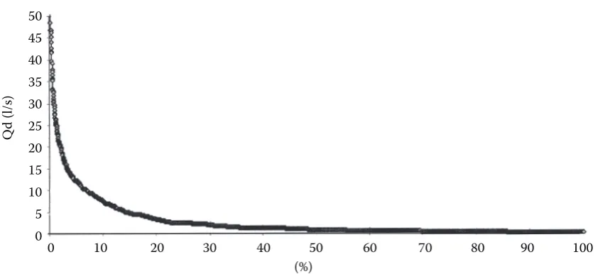
Table 1 shows some examples of the main pa-rameters of drainage systems and their functions in experimental catchments monitored by VÚ-MOP. Details of the characteristics and evalu-ated data on these catchments were presented for instance by Soukup (2001, 2004) and Soukup et al. (2004, 2005). In the experimental catchments the measured characteristics included precipita-tion, flows, drainage runoffs, soil moisture and tension, saturated hydraulic conductivity of soil, groundwater level between drains in shallow wells and in deep wells.
[image:3.595.66.531.588.737.2]Based on the results of measurements and on the evaluation of the scenarios of climatic changes a new calculation of drain spacing was carried
Table 1.Experimental catchments and parameters of drained areas/groups*
Experimental
catchment Height above sea level (m) area/groupDrainage Drainage area (ha) Spacing and depth of drains (m)
Cerhovice Stream 390–572
Š 1 2.50 18/0.9
Š 8 23.50 8–15/1.0
Š 7 40.50 9–15/1.0
Černičí 448–543 Š 1 0.60 13/1.0
Š 2 5.04 13/1.0
Žejbro (Pokřikov
and Kladno) 355–676
Š 1 6.23 8–14/0.9–1.0
Š 2 4.92 8–12/1.0
Ovesná Lhota 506–550 Š 6 17.83 11–12/1.0
out. The original determination of the spacing of the drains, i.e. the layout of the drain system on arable land up to the slope of 2%, was carried out according to the standard ČSN 75 4200 (1993) and earlier standards, if any, on the basis of:
(a) grain size composition of the soil environ-ment,
(b) hydrological relations, (c) farming conditions.
Most drainage systems were projected consi-dering:
(a) to what extent the limit of precipitation is restricted by the annual sum of precipitation 600 mm,
(b) results of the analysis of Hooghoudt’s and Ernst’s equations that were used for the calculation of stabilised streaming. In this solution, the precipitation or the proposed specific drain-age runoff (m/d), if any, are also decisive. An important term of the equations is the coef-ficient of unsaturated hydraulic conductivity that was measured on some of the areas and used for the calculation. The proposed specific drainage runoff is also a very important value for the determination of drain spacing,
(c) farming conditions, which were represented mainly by the requirements of prevailing crops to be grown on the drained plots. Another type of economic changes is the change of land use.
Farming conditions
The analysis of land use conditions on drained lands proves that the land use as well as farming conditions have changed significantly. For instance, if arable land which was drained is currently used as a permanent grassland or pasture, the soil water regime will not be optimal any longer. In case that the farming conditions have changed significantly, let us say during the last decade, the designed parameters of the existing drainage systems are also inadequate.
reSultS AnD DiSCuSSion
Probable changes in precipitation and their im-pact on the hydrologic regime of the catchment are predicted by the scenarios in the National Climatic Programme of the Czech Republic – NKP
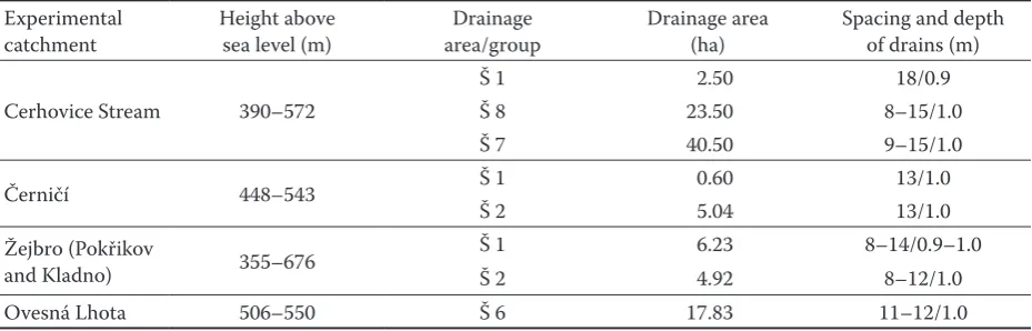
Figure 1. Reduction of total runoff in the Elbe catchment (Brandýs nad Labem) – National Climatic Program (2002)
Time (months)
XI XII I II III IV V VI VII VIII IX X
according to observations EC1L
EC2H Ha1L Ha2H 35
30
25
20
15
10
5
Ru
no
ff
(m
m
/m
on
th
[image:4.595.70.515.441.716.2]CR (Kalvová et al. 2002). According to the mod-els listed above there is a distinct reduction of precipitation in all the used scenarios in July and August, which are the months of the vegetation period. As the spring runoff from snow melting as well as the yearlong basic runoff (Figure 1) are diminishing, the result is a considerable drop of total runoff from the catchments all the year round. An example of the catchments of the Elbe river, Brandýs nad Labem locality is shown.
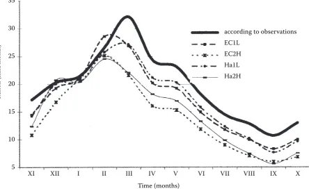
[image:5.595.81.511.82.275.2]The solid curve represents the average of monthly runoff in mm. The other four curves were con-structed on the basis of four scenarios. The up-per two curves can be considered as optimistic scenarios and the lower two curves as pessimis-tic ones. The differences in total runoff of the individual months with the exception of winter months are evident and reach 3–5 mm in optimistic scenarios and 5–10 mm in pessimistic scenarios. The yearlong reduction of total runoff makes 25 to 70 mm. It can be expected that the drainage runoff will also be reduced as it is a part of total runoff. The probability curve of exceeding drainage run-offs was constructed on the basis of observations of drainage runoffs in experimental catchments (Figure 2). Statistical data concerning the main characteristics of the runoffs were processed on the basis of data files.
The statistical data show that the average monthly drainage runoffs reach their maximum in January and February (max. 0.124 1/s/ha). Above all in the spring season there is a strong need to drain water away. In the summer months the drainage runoff
drops as low as to the value of 0.037 1/s/ha as measurements in the catchment of the Cerhovice stream showed and the groundwater levels were reduced by drainage when the soil profile is satu-rated only after larger precipitation.
It follows from the analysis of drainage runoff that this runoff is episodic only in some localities and relatively stable in the other ones. Therefore its reduction is also changeable, depending on the conditions that cause the runoff. The precipita-tion-runoff process is influenced more by the time distribution of rainfalls than by the amounts of rainfalls. The reduction of drainage runoff is not linear in any case.
The comparison of the calculated spacing of parallel collection drains with the existing spac-ing in experimental sites shows the changes in the spacing of drains from 10 to 40%.
The results show that it is necessary to reduce the efficiency of the constructions in many cases. Besides the climatic changes, it is also necessary to take into account the changes of economic con-ditions that also form a part of basic data for the designs of the constructions. It is indispensable to embody the changes and to evaluate the rate of their influence on the function of the existing systems.
As it is evident, it is practically impossible to change the basic parameters of the classic drain-age systems in situ, i.e. the depth and the spacing of drains (it would be possible to increase the network density, but it is rather a question of the opposite). So it is necessary to choose such an 50
45 40 35 30 25 20 15 10 5 0
Q
d
(l/
s)
0 10 20 30 40 50 60 70 80 90 100
(%)
adjustment that will lead to a partial limitation of the function of the system or that will reduce the runoff totally.
The measures to be taken in surface drainage are as follows:
− runoff regulation/retardation,
− insertion of transversal objects to the open sur-face network of trenches and channels,
− raising the bottom of the trench and adjustment of the passage profile,
and the following measures should be taken in underground drainage systems:
− limitation of the inflow to drains,
− limitation of the passage profile of drains, − spot hold up of runoff in drainage (regulation)
shafts,
− placing retardation elements into the under-ground pipe network.
Adaptation of drainage systems
Local conditions and the endeavour to optimize water management have led to the development of specific regulation and retardation measures. The regulation dates back to the 19th century. The
regulation drainage developed by I. Radčenko, F. Kulhavý and others in the second half of the 20th century can be applied, however, in a flat
ter-rain only. Since the eighties of the 20th century,
new methods have been developed that can be used in the slope of terrain up to 5%. The slope of both the terrain and the drainage pipeline should be taken into consideration. Researches resulted in a technical standard: Regulation and Retardation on Agricultural Lands Drained by Pipe Drainage, issued by Ministry of Agriculture of the Czech Republic and Hydroproject CZ Ltd Prague – TNV 75 4221 (2004).
This Standard recommends several ways of drain-age runoff retardation:
− Regulation drainage
− Retardation area drainage (designed by P. Dvo-řák)
− Drainage with controlled runoff
− System of underground retardation of drainage runoff, PRO system (PRO is a Czech abbrevia-tion)
− Regulation of runoff from spring sumps − Diversion and transfers of drainage waters − Reduction/elimination of drainage system
func-tion
− Drainage system with the pumping of water
It is important for water management measures to resolve all hydrologic situations that can occur.
The measures to reduce the impacts of possible climatic changes on water management require first of all:
− to evaluate systematic observations of water balance of small catchments especially during dry periods,
− to take new strategic decisions and to set new priorities in the water management sector, − to take complex water management measures
based on the evaluation of the need of water in catchments,
− to develop a programme of construction and reconstruction of water management structures in order to reduce the runoff, and
− to develop a programme of modernisation of structures and systems of agricultural land drain-age,
− to introduce efficient ways of irrigation, − to carry out the reconstruction and maintenance
of existing systems,
− to increase the protection of basic natural re-sources of soil and water,
− to ensure regular protection of vegetation growths, maintenance and construction of anti-erosive measures and conservation of hydrologi-cal functions of forests.
The above measures are in accordance with the Framework Regulation of Water Policy of the European Union (Chave 2001) and could help to adapt water management to climatic variabilities and changes. The proposals of measures are based on traditional methods. A modern approach is described in the document of the 9th International
Drainage Workshop, Utrecht, Integrated Water Resources Management – IWRM (2003).
After arable land was converted into permanent grasslands, a number of drainage systems became over-dimensioned. With respect to the protection of nature and to the optimal structure of the land-scape (landland-scape mosaic), it would be suitable to carry out their modernisation in such a way that the systems would meet the requirements and conditions of the present time.
ConCluSionS AnD reCoMMenDAtionS
catchments. In the agriculturally used landscape in which drainage is applied it will be necessary to regulate and retard the runoff. The single-function and outdated drainage systems have to be modernised and double-function regulation systems should be introduced. Therefore it is necessary:
− to reassess the used measures (drainage and irrigation) in view of possible climate change and subsequent changes of runoff,
− to carry out adaptation of those systems that do not meet the required aims,
− to propose measures for the regulation and con-trol of water runoff corresponding to the require-ments of natural resources protection.
During the increase of extreme precipitation the risk of erosion damage to the pipe network placed shallowly under the surface of the ground will increase. This concerns especially the incor-rectly situated pipe channels and collection drains. The farming changes that occur at present in the use of the drained land are another reason for the introduction of additional functions to the drain-age constructions:
− improvement of water economy in the soil and in the respective catchments,
− reduction of drainage and total runoff,
− improvement of the conditions for the ground-water inflow.
The revitalization and adaptation of agricultural drainage networks should be included in the Pro-gramme of Revitalisation of River Networks and Solution of Complex Land Adaptations.
For the Czech Republic it is high time to ex-amine the current state of the existing drainage system networks and to stimulate the owners or administrators of such systems to start their re-construction and conversion in accordance with the main environmental and hydrologic functions of catchments and with the programmes that are already under way in the individual basins and should therefore be resolved with partial financial subsidies on the part of the government.
references
Chave P. (2001): Rámcová směrnice vodní politiky. Za-váděcí směrnice Evropské unie. MZe ČR, IWA Pub-lishing, Praha.
ČSN 75 4200 (1993): Hydromeliorace. Úprava vodního režimu zemědělských půd odvodněním.Český norma-lizační institut, Praha.
Fídler J. (1977): Vliv požadavků intensity odvodnění na velikost drenážního odtoku. Sborník ÚVTIZ – Melio-race, 13: 119 – 128.
Kalvová J., Kašpárek L., Janouš D., Žalud Z., Kazma-rová H. (2002): Zpřesnění scénářů projekce klimatické změny na území České republiky a odhadů projekce klimatické změny na hydrologický režim, sektor zeměděl-ství, sektor lesního hospodářství a na lidské zdraví v ČR. Národní klimatický program České republiky, Praha. Kulhavý Z., Čmelík M., Eichler J. (2000): Souhrnné
zpracování databáze experimentálních povodí Žejbro. VÚMOP Praha, Pardubice.
Soukup M. (2001): Extend and function of drainage sys-tems in experimental catchments of VUMOP. (in Czech with English abstract) In: Doležal F. (ed.): Proceedings of the Workshop Nové Hrady, Experimental Agricultural – Forest Catchments VÚMOP in Central Bohemian Crystallinicum. VÚMOP, Prague, 23–36.
Soukup M. (2004): Pravděpodobné důsledky klimatických změn na hydrologický režim zemědělsko-lesních odvod-něných povodí. [Výzkumný záměr.] VÚMOP Praha. Soukup M., Kulhavý Z., Maxová J. (2004): Vláhový
režim odvodněného půdního profilu s regulací odtoku a jeho vliv na hydrologické procesy v krajině. [Závěrečná zpráva.] VÚMOP Praha.
Soukup M., Kulhavý Z., Pilná E. (2005): Funkce země-dělských odvodňovacích systémů v současných a budou-cích hospodářských a klimatických podmínkách. Vodní hospodářství, 55:189–204.
Švihla V. (1991): Odvodňovací systémy s optimalizací hydrologické funkce. Vědecké práce VÚMOP Praha, č. 7: 64–72.
Vašků Z. (1989): Drénový fenomén. Sborník ÚVTIZ – Meliorace, 25: 131–140.
Received for publication December 6, 2005 Accepted after corrections February 20, 2006
Corresponding author:
Ing. Mojmír Soukup, CSc., Výzkumný ústav meliorací a ochrany půdy Praha, Žabovřeská 250, 156 27 Praha 5-Zbraslav, Česká republika