LYTTELTON
HARBOUR
JNEW ZEALAND
A thesis
submitted in fulfilment of the requirements
for the Degree
of
Doctor of Philosophy in Geography
in the
University of Canterbury
by
R.J. Curtis
University of Canterbury
FRONTISPIECE. An oblique aeri al vi ew looking down Lyttelton
Harbour. Banks Peninsula is to the left.
Photograph by Mannering and Associates Ltd,
ABSTRACT
The principal concern of this study is the examination
of sedimentation and sedimentary processes in a rock-walled
tidal inlet, Lyttelton Harbour.
The harbour is distinctive
from other forms of inlets commonly discussed in the literature
due primarily to a negligible freshwater input, lateral grain
size contours which are parallel to current flow paths, and
a maintenance, channel dredging programme which greatly exceeds
the natural harbour sedimentation rates.
A further unusual
characteristic of the harbour is the lateral limitation imposed
on processes within the harbour by the surrounding rigid, rock
boundaries.
These boundaries influence and control circulation
patterns within the harbour through the interaction between
processes and geometry.
Thus Lyttelton Harbour is a structurally
controlled tidal inlet.
The only harbour boundary which is
free to respond to changes in the system is the bed.
For these
reasons traditional inlet concepts, applicable to estuaries and
inlets with unconsolidated boundaries, were found to be
unsatisfactory for explaining how Lyttelton Harbour operates.
The study approach involves fieldwork and analysis of
both sedimentary and hydraulic processes within the harbour.
A bed sediment survey showed that the harbour can be divided
along its longitudinal axis with very fine mud sediments on
the northern side, and coarser, sandier sediments on the
southern side.
All bed sediments are predominantly fine, and
a survey of near-bed suspended sediment concentrations revealed
fluid mud layers on the northern side of the harbour, at the
The primary hydraulic processes operating are tidal currents, although a mixed wave field, comprising ocean swell and locally generated wind waves, frequently penetrates the harbour. Tidal current velocities are on average around 0.22 ms-l , with flood tide velocities stronger on the south side of the harbour and ebb tide velocities stronger on the north side, inducing a clockwise circulation pattern.
External factors are an important component in the tidal driving forces, comprising coastal weather patterns and a
continental shelf edge wave oscillation effect with a period of 2.5 - 3.5 hours. These external influences are the main cause of the duration of both ebb and flood tides varying from 5.0 to 8.25 hours. Interaction between tidal currents and the harbour geometry induces a large gyre in the outer harbour which varies in duration from being absent to operating for up to 50% of any given tidal cycle.
The transport of sand sized material is bidirectional along the harbour length, with erosion of sandy sediments in the centre of the harbour, and deposition at the head of the harbour and at the harbour entrance. Fine muddy sediments are transported predominantly towards the harbour entrance and accumulate in the channel, on the northern side, and in the entrance, forming fluid mud layers. The most concentrated fluid mud regions coincide with the rotatory currents at both ends of the tidal gyre, where sediment is deposited from weaker currents. Transport of sand across the harbour is not
size, from coarse to fine, across the harbour from south to north.
The major sedimentary process within the harbour is the maintenance dredging programme which removes up to 1,000,000
tonnes of sediment annually from the channel and port berthage areas. The dredge spoil is subsequently dumped within the harbour along the northern perimeter, although a temporal
analysis of dump sites indicated that once a site capacity has been attained, all the spoil dumped at that location is rapidly removed. Sediment input from other sources, primarily erosion of the catchment, has been estimated at less than 45,000 tonnes per annum, substantially less than the channel siltation rate, and the recirculation of dredge spoil was identified as the primary source of sediment causing channel siltation.
Two processes induce spoil recirculation. Firstly the tidal gyre, and secondly the dynamic trap. The dynamic trap system provides a mechanism for the transport of fine grained sediments to regions of high sediment flux, and for the
deposition of fine grained sediments under current regimes having both a high competence and a high capacity. The system provides an explanation for the lateral grain size gradation within the harbour, the maintenance of dredge spoil mounds at dump sites, the insensitivity of channel siltation rates to the
location of spoil dumping sites around the harbour, and the quasi-equilibrium state of the harbour in spite of the
extensive dredging operations. Little sediment is able to escape from the harbour to the open sea due to the flux gradients at the entrance, and the dynamic trap principles.
redistribu-tion of available sediment within the harbour as a funcredistribu-tion of internal harbour dynamics.
Throughout the thesis the dynamics of Lyttelton Harbour are compared to existing inlet concepts and theories in order to identify those areas in which this type of inlet is
significantly different and where other, poorly understood inlets may be comparable to Lyttelton. Finally, Lyttelton Harbour is defined and classified and a set of principles pertaining to this type of inlet are proposed.
Chapter
ONE
TWO
THREE
TABLE OF CONTENTS
ABSTRACT
LIST OF TABLES LIST OF FIGURES LIST OF APPENDICES ACKNOWLEDGEMENTS
INTRODUCTION
1.1 STUDY APPLICATIONS 1.1.1 Applied Aspects
1.1.2 Application to Inlet and Estuarine Sedimentation 1.2 NATURE OF THE STUDY AREA
1. 2.1 Previous Studies of Lytte1ton Harbour 1.3 AIMS AND APPROACH
1.4 THESIS FORMAT
ESTUARINE PROCESSES 2.1 DEFINITIONS
2.2 INLET CLASSIFICATION SCHE~lliS
AND PARAMETERS
2.2.1 Circulation and Mixing Processes
2.2.2 Sedimentation Processes
SEDI~ffiNTATION REGIME IN LYTTELTON HARBOUR: HISTORICAL CHANGES AND CONTEMPORARY
PATTERNS
3.1 HISTORICAL BATHYMETRY: DEPOSITION AND EROSION
3.2 SEDIMENTS
Page
iii
xi xiii xviii xix 1 4 4 6 9 13 17 19 22 22 25 31 36 43 44 53 3.2.1 Sampling and Textural Analysis 53 3.2.2 Distribution of Mean GrainChapter
FOUR
FIVE
3.3 SEDIMENTATION PATTERNS
3.3.1 Rollability Analysis of Sand 3.3.2 Fluorescent Sand Tracing 3.3.3 Suspended Sediment and Fluid
Mud
3.4 SEDIMENT ORIGINS
3.4.1 Sediment Input from Catchment Erosion
3.4.2 Fluvial Suspended Sediment Load
3.4.3 Recirculation of Dredge Spoil 3.5 SUMMARY
HYDROGRAPHY
4.1 SALINITY AND DENSITY CURRENTS 4.1.1 Circulation and Density
Currents 4.2 TIDAL PHENOMENA
4.2.1 Spectral Analysis of the Tidal Wave
4.2.1.1 Tidal Variability, Weather Forcing, and
Page 67 67 77 79 89 89 93 95 102 105 106 114 115 120
Edge Wave Oscillation 128 4.2.2 Tidal Currents
4.2.2.1 Dye Tracing to Determine Dispersion, Mixing,
132
and Flow Paths 140
4.3 CIRCULATION PATTERNS 4.4 SUMMARY
EFFECTS OF WAVES AND TIDAL CURRENTS ON HARBOUR SEDIMENTATION
5.1 WAVE ANALYSIS 5.1.1
5.1.2 5.1.3 5.1.4
Wave Spectrum
Wave Effectiveness Wave Refraction Wind Waves
Chapter
SIX
SEVEN
5.2 DISCUSSION: HYDRODYNAMICS AND SEDIMENTATION
5.2.1 Threshold Erosional Velocities
5.2.2 The Transition Zone Between Upper and Lower Harbours 5.2.3 Sedimentation: Transport,
Deposition and Distribution 5.2.3.1 Tidal and Sediment
Circulation
5.2.3.2 Channel Siltation 5.3 CONCLUSIONS
SEDIMENTATION AND STABILITY 6.1 THE STABILITY CONCEPT
6.2 MECHANISMS OF FINE GRAINED SEDIMENT TRANSPORT AND DEPOSITION
6.2.1 Sediment Flux Differentials in Lyttelton Harbour
6.3 THE DYNAMIC TRAP: A DEPOSITIONAL MODEL FOR FINE SEDIMENTS
6.4 STABILITY OF LYTTELTON HARBOUR 6.5 CONCLUSIONS
MANAGEMENT AND SCIENTIFIC APPROACHES TO TIDAL INLETS: AN APPRAISAL WITH RESPECT TO LYTTELTON HARBOUR DYNMlICS
7.1 PROCESSES CLASSIFYING WELL MIXED ESTUARIES
7.l.1 Hydraulic Criteria 7.1.2 Sedimentary Criteria 7.2 TIDAL INLET CLASSIFICATION
7.2.1 Classification of Lyttelton
190 190 192 195 197 199 202 207 207 210 214 226 232 241 244 245 245 250 255
Harbour 257
7.3 DISCUSSION: APPROACHES TO
STRUCTURALLY CONTROLLED INLETS 264 7.3.1 General principles Pertaining
Chapter
EIGHT
7.4 CONCLUSIONS
CONCLUSIONS
8.1 STUDY EVALUATION AND SUGGESTIONS FOR FURTHER RESEARCH
REFERENCES
APPENDICES
275
277
288
291
Table 3.1 3.2 3.3 3.4 3.5 3.6 4.1 4.2 4.3 4.4 5.1 5.2 6.1 6.2 6.3
LIST OF TABLES
Volumes of sediment movement in Lyttelton Harbour through time. Description of sediments grouped in terms of environmental
conditions.
Selected Relative Rollability Values. Catchment erosion rates:
A. Foreshore from aerial photographs. B. Loess road cuttings from erosion
pins.
Winter stream discharge and suspended load. (July 1984)
Tonnes.m-2 of sediment lost from dump sites per annum, expressed as a percentage of tonnes dumped at each site per annum.
Some tidal constituents and their characteristics.
Spectral density values from analysis of tidal water levels. Tidal current data.
Times of current direction change at designated stations with respect to observed times of high and low water on the inner harbour tide gauge.
Main wave recording categories in terms of significant height and period.
Maximum wave effectiveness values for various wave forms at given depths (MSL)
Harbour dimensions and conditions used in calculating the Chezy coefficient and sediment flux values.
Characteristics for flux calculations, and flux values for tidal current
stations and harbour entrance.
Table
7.1
Entrance Distance/Width ratios for
(A) Lyttelton Harbour current
stations, and
Figure 1.1 2.1 3.1 3.2 3.3 3.4 3.5 3.6 3.7 3.8 3.9 3.10 3.11 3.12 3.13 3.14 3.15
LIST OF FIGURES
Location of study area.
Typical salinity and velocity profiles in estuaries.
Graph of changes in area less than a given depth vs depth through time. Datum is Mean Low Water Neap.
Graphs of harbour deposition and scour through time plotted as area less than a given depth vs depth. Datum is MLWN.
Graphs of rates of sediment
accumulation for various harbour depths with respect to the 1849 contours.
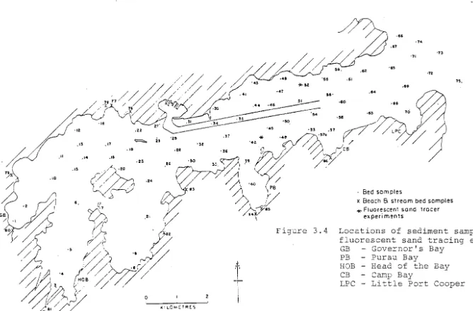
Locations of sediment samples and fluorescent sand tracing experiments. Spatial distribution of harbour
sediments.
Percent content contours showing spatial distribution of fine to very fine sand. (2 - 4¢)
Percent content contours showing spatial distribution of clay size material «8¢).
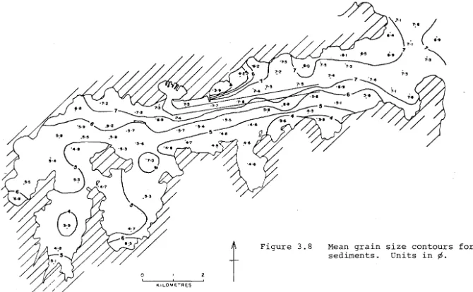
Mean grain size contours for bed sediments. units in
¢.
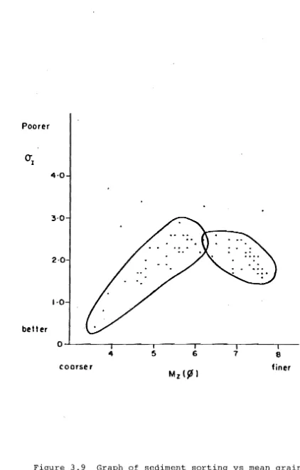
Graph of sediment sorting vs mean grain size.
Spatial distribution of sediment sorting characteristics.
Average relative rollability (%) distribution for whole samples.
Relative rollability (%) distribution for very fine sand fraction (62 ~m).
Suspended sediment and fluid mud sampler. Graphs of near-bed fluid mud samples
and suspended sediment profiles up to 1 m above the fluid mud layers.
Distribution of fluid mud and suspended sediment concentrations at z = 5.1 cm Units - gil.
Figure 3.16 3.17 3.18 3.19 4.1 4.2A 4.2B 4.3 4.4 4.5 4.6 4.7 4.8 4.9 4.10 4.11
Suspended sediment concentrations
at z = 1 m over a tidal cycle, at
current stations 1 and 2.
Location of foreshore erosion profile sites in Governor's Bay, Head of the Bay, and Charteris Bay.
Graphs of tonnage dumped and tonnage remaining over time for harbour
spoil dump sites.
Location of channel dredge sections with respect to spoil dump sites.
Longitudinal salinity survey. 1.5 hours either side of low water, showing
surface salinity values (7.5.84).
Longitudinal salinity survey showing the vertical profiles (7.5.84).
Longitudinal temperature survey showing vertical profiles (7.5.84).
Salinity profiles.
A. Cross-sectional harbour profile (7.5.84).
B. Surface values in the upper harbour following heavy rain (1.10.84).
Extract from the tide gauge water level curve from 24.8.84 to 27.8.84. Protuberances are associated with edge wave oscillations.
Graphs of tidal residuals for ebb and flood tides: Observed tidal duration minus expected duration from tide charts.
Spectral density graphs showing main tidal constituents and peak frequencies.
Graphs of QNH pressure differentials and tidal variability.
Spectral density and coherence graphs.
Spectral density and coherence graphs.
Location of tidal current stations showing flow direction vectors.
Current velocity curves for four stations plotted against the tidal water level curve, showing velocity vs phase of the tide.
88 90 97 101 108 110
I I I
Figure 4.12 4.13 4.14 4.15 4.16 4.l8 4.19 4.20 4.2l 4.22 5.1 5.2 5.3
Current velocity profiles taken over 5 min. intervals.
A. Calibration curve for Rhodamine WT
B. Loss of fluorescence in Rhodamine WT
with salinity.
Sampling grid for dye tracing experiment.
Dye dispersion contours. Concentrations in 1-11/1 x 10-6
Flood tide flow paths through the harbour entrance. Data were obtained by the
Lytte1ton Harbour Board from surface float tracking.
Dye concentration of sample sites. indication of the mixing throughout
profiles at a number The profiles give an degree of vertical the water column. Current flow data from current stations plotted against simUltaneous water level curves from the tide gauge. The curves were used to examine the times of flow direction change at current stations with respect to high and low water at
141 144 146 148 151 152
the tide gauge. 156
Harbour circulation patterns for ebb
and flood tides. 159
Development of the harbour circulation pattern for average flow conditions over
a tidal cycle. 161
Surveyed water level changes at Go11ans Bay and Breeze Bay over half a tidal cycle
(5.4.84). Low water at each site has
been adopted as the zero datum. 163
Aerial photographs showing the ebb tide eddy and the possible development of shear lines between the breakwater and
the entrance to Purau Bay. 165
Examples of wave chart categories used as standards for wave analysis. These
records were unsatisfactory for digitizing. 171 Wave spectrum. Data are from averaged
recording interval categories. 176
Graphs of the distribution of wave effectiveness with respect to harbour
Figure 5.4 5.5 5.6 5.7 5.8 5.9 6.1: 6.2 6.3 6.4 6.5 6.6 6.7
Threshold erosional velocities under waves for a number of wave periods. Velocities calculated after Pickrill and Currie (1983).
Wave refraction diagrams for an ENE wave direction.
Monthly wind direction frequencies for Lyttelton Harbour. Contours are observations per thousand.
Threshold erosion and deposition
velocity curves for uniform material. scattergrams of tonnage of spoil
dumped vs siltation rates in channel sections adjacent to the dump site
(1968-1983) •
Bed slope profiles at spoil dump sites over time showing changes in slope gradients.
Relationship between calculated shear stress values and current velocities in Lyttelton Harbour.
Scattergram of mean velocity vs flux with regression equations applied to the total sample (A) i fine grained muds (B); and coarser sandier
sediments (C).
Power functions of the velocity/flux regression curves in Figure 6.2 with the data forced through zero.
The Dynamic Trap: A model for fine grained sediment transport and
deposition under conditions of high near-bed suspended sediment concen-tration.
The Dynamic Trap model applied to flux values, as a function of mean ebb tide current velocities at current stations 10, 11, 12, and the harbour entrance. Calculated flux values applied to the Dynamic Trap model as a function of: A. Velocity gradients between stations. B. Distance between stations.
Regions of fine grained sediment
deposition within the harbour, calculated from flux values and the (F I -F2 )/D ratio.
Figure
7.1
7.2
Geometry and circulation character-istics of two other rock-walled
inlets: Wellington and Akaroa Harbours.
scattergrams of flux values vs the dimensionless DE/W coefficient for Lyttelton Harbour.
260
Appendix
1
2
3
LIST OF APPENDICES
Summary of Folk Parameters for Lyttelton Sediments.
Spectral density curves for tidal data for differing sampling intervals
showing relative shifts in peak
power densities (shown in brackets) •
Contours of suspended sediment during dye sampling at depth
Z/Zo
=
0.2. Concentrations in rng/l.304
308
ACKNOWLEDGEMENTS
I wish to express my sincere thanks to the many people and organisations who helped to make this study possible. In particular, I wish to thank my supervisor, Dr. Bob Kirk, for his advice and guidance with the thesis, and for the time he has given to our many long discussions during the past few years.
I also wish to thank the Lyttelton Harbour Board who provided the financial and logistic support without which the study would not have been possible. Many thanks must go to the launch drivers, divers, engineers, and the many people on the Harbour Board staff who helped by providing equipment, assistance in the field, and information and suggestions about the harbour and the study.
Glen Lauder, Laurie Brown, and Mark Siemelink all helped with an important aspect of my fieldwork by spending a tiresome day at the edge of the harbour watching the tide
go out and come in again. My thanks to them for their patience. I wish to acknowledge Dr. Ian Owens, his library, and his calculator. They all provided very useful suggestions and information for the thesis. Drs. Lionel Carter and Dick
Pickrill of the N.Z. Oceanographic Institute also provided some helpful comments on the study.
My thanks to the technical staff in the Geography
Department for their invaluable assistance with field equipment, draughting and computing, and also to Mrs. Glenys Lamb for a superb job with the typing.
ONE
INTRODUCTION
This study concerns sedimentation and sedimentary processes in a rock-walled coastal inlet. Lyttelton Harbour is a volcanically formed tidal inlet comprising a structure of hard rock walls and a single mobile boundary at the bed. The harbour contains the Port of Lyttelton which serves the largest South Island city, Christchurch, and is situated approximately 9 km from the harbour entrance. Figure 1.1 and the frontispiece show the location of the harbour and the port. Access to the port for shipping is via a dredged
channel which is maintained by an extensive, ongoing dredging programme.
Lyttelton Harbour can be seen to "differ" from most coastal inlets in a number of important respects. The harbour is notable for a negligible freshwater input, very fine mud sediments, and exposure to a wave field of effectively
unlimited fetch. Siltation rates in the dredged channel are far in excess of the natural sediment input from either
Prior to the period of extensive dredging and dumping in the outer harbour the bed of the harbour appears to have been in approximate equilibrium. Over the period from 1849 to 1951 no significant increase or decrease in the volume of harbour sediments is apparent. The equilibrium is a dynamic form of equili-brium in that where the equiliequili-brium bed levels are altered the system operates to restore the equilibrium levels. Despite the relative stability of the natural bed levels, indicating perhaps small quantities of sediment in motion, the sediment cha'rge of the system is consider-able as is evidenced by the channel siltation. The dredged channel is an example of the
equilibrium depth being exceeded. In the case of the dredge dumpings ... the system operates to increase the depth back to its former equilibrium level.
This statement raises several points of considerable scientific interest with respect to how the harbour functions and how i t responds to change. The implications are, that prior to "extensive" dredging the harbour was in a state of equilibrium, and then following the introduction of dredging operations the harbour has reached another, different, state of equilibrium with "relatively stable natural bed levels indicating small quantities of sediment in motion". Thus
two separate phases of harbour equilibrium have been inferred; a historical one when the harbour was in a natural state;
and a modern one with the harbour substantially altered by the dredged channel, dumping of spoil, and to a lesser degree by features such as the construction of moles and breakwaters at the port. Furthermore, while Bushell and Teear (1975) proposed stable bed levels they also suggest the sediment charge of the harbour "is considerable as evidenced by
sea although this was not determined by Bushell and Teear. It is interesting to note that the Lyttelton Harbour Board's dredging records show little change in equilibrium conditions since dredging began, despite the utilization of seven major dump sites at different locations around the harbour during this period.
The existence of the two separate 'states of equili-brium' has not been demonstrated categorically. If i t can be shown that they do exist, then several important questions arise:
(11 What factors controlled harbour stability under natural conditions, in an inlet possessing only one mobile
boundary which can be subjected to alteration to achieve stability?
(2) In what manner did the harbour respond to substantial changes to the system, in the form of the channel, which upset the equilibrium?
(3) What factors currently control harbour stability under the new conditions, with the channel dredged and spoil dumped within the harbour?
The purposes of this thesis therefore, are to examine the hydrodynamics and sedimentation of Lyttelton Harbour and to investigate the nature of the harbour stability in order to determine the factors which control the harbour dynamics and equilibrium conditions. As indicated in the foregoing discussion, the main factors which appear to be pertinent to the study, such as dredging operations and boundary mobility, are internal to the harbour.
tidal inlets, as opposed to those at the entrance, have been little studied and are poorly understood. In particular, there is a conspicuous dearth of literature examining
hydraulic and sedimentary processes within "rigid boundary" inlets such as Lyttelton, and the interactive effects between these processes and a hard rock geometry. Analysis and
determination of the factors which influence the physical processes and control the stability of Lyttelton Harbour will therefore provide a significant contribution to the broader scientific knowledge relating to tidal inlets in general.
1.1 STUDY APPLICATIONS
l . l . l Applied Aspects
Lyttelton is New Zealand's deepest draught and berthage port due to the large scale maintenance dredging operation which began in 1876 (Scotter, 1968). The existing schedule maintains a 7 km channel at approximately 12 m
depth, mean low water spring tide {MLWS}, shown in Figure 1.1, and requires the removal of 700,000 to 1,500,000 tonnes of sediment per annum from both channel and berthage areas. While a small percentage of this quantity has been dumped at
Two main reasons exist for dumping spoil within the harbour. Firstly, any dredging policy ideally establishes an optimum between the two extremes of continuous dredging and dumping directly over the side, whereby maximum quantities of sediment are both removed and recycled, or achieving
~ minimal dreding but dumping at sea so that minimal spoil
recycling occurs. Primary factors involved in decision making in dredging are the ability to maintain the desired channel depth, and the cost of operating the dredge. Dumping spoil along the edges of the harbour is the policy adopted by the Lyttelton Harbour Board.
The second reason, and the major reason for transferring dump grounds from the southern to the northern side of the
harbour, reflects an attempt to regulate the wave environment within the harbour. Bushell and Teear (1975) report that
spoil mounds are formed on the sea bed on the northern side to induce wave refraction and reduce wave energy. They found evidence for " ••. a significant wave energy reduction in the harbour due both to the effects of selective dumping,
. . . and due to the extension of the channel".
To date the transport of spoil from the dump sites and its resultant deposition have not been ascertained, so that the 'validity' of the reasons for dumping spoil within the harbour has not been established. Furthermore, since spoil is likely to comprise a major proportion of the sediment available for transport within the harbour, knowledge of the manner in which i t accumulates or is redistributed will
immediate source of sediments entering the channel, the
transport mechanisms and directions of spoil from the dumping sites, and the effects of dredging, in particular spoil
mounds, on the harbour dynamics and stability.
An additional aim of the applied side of the study is to assess the possibility of a reduction in dredging opera-tions. Although a large degree of interaction between physical processes and dredging is predicted here, earlier studies of the hydrodynamics and sedimentation in Lyttelton by Brodie (1955), Garner and Ridgway (1955), and Heath (1975), have ignored the effects of spoil, save to indicate that i t increased the rate of shoaling of the harbour bed (Brodie, 1955). Any knowledge of the interrelationships between
processes and dredging gained from this study should provide considerable insight into management criteria not only for Lyttelton, but for similar types of inlets and harbour dredging operations in general.
1.1.2 Application to Inlet and Estuarine Sedimentation
Examination of tidal inlet literature reveals that most work undertaken has concentrated on hydraulic processes. Thus Krause and Ohm (1984; p.61l) observe that;
Net transports of seston, occurrence of turbidity clouds and mud deposition are phenomena which are not properly understood scientifically, and the necessary dredging of shipping channels through estuaries poses numerous practical and financial problems.
This lack of knowledge of estuarine sedimentary
mixing in the water column, and this analysis leads almost by implication to the circulation pattern in the inlet. Numerous papers exist examining circulation and hydrology in estuaries (e.g. Arons and Stommel, 1951; Bowden, 1960, 1967,1977; Dyer, 1977; Garvine, 1977; Hansen and Rattray, 1965; Haas, 1977; Officer, 1977; Pritchard, 1955, 1967a: Rattray, 1977: and many others). Fewer studies include work on sedimentation in estuaries, and where i t is included
sedimentation tends to be analysed in terms of the estuarine circulation patterns rather than the actual mechanisms
involved in the sedimentation process. A resultant feature of estuarine circulation is the "turbidity maximum"
(Section 2.2) which Allen et al. (1976) consider " . . . controls the sedimentation of suspended sediment in estuaries ... ". Dyer (1979: p.ll) states that " •.• the estuarine circulation pattern is important in determining the sediment movement". However, in one type of estuary classified by Pritchard
(1952) as "well mixed" and having no vertical salinity
structure, Allen et al. (1980) and Castaing and Allen (1981) have recently indicated that tidal processes may be more important than "estuarine" processes in transporting fine sediments. In these inlets, applying estuarine concepts such as turbidity maxima to infer sedimentation patterns,
as suggested by Dyer (1979) and done by Inglis and Allen (1957), would therefore appear to be rather tenuous.
cases they group inlets by a set of basic principles based on physical parameters of the inlets and from these, general principles are derived for dynamics and circulation patterns to be applied to other inlets with similar physical parameters. Thus by the very nature of the classification systems,
processes operating within inlets, particularly with respect to sedimentation, tend to be inferred from other physical parameters rather than being determined from actual measure-ments. In Section 4.1 i t is demonstrated that Lyttelton
Harbour is not an estuary, and yet i t will also be demonstrated in the ensuing chapters that many of the characteristics
applicable to the description of well mixed estuaries are also applicable to the description of Lyttelton; such as lateral circulation and tidal mixing. However, concepts
which have been developed in the literature to describe inlets and estuaries are unsatisfactory by themselves for explaining those features of Lytte1ton mentioned at the outset of this chapter and which make i t "differentll.
It should be reiterated here that a particular aspect of Lyttelton which makes i t different from most non-estuarine tidal inlets examined in the literature is its solitary mobile boundary at the bed. Most tidal inlets studied have multiple mobile boundaries, and because the commercial viability of
Thus, while this study will utilize many principles and techniques which already exist in the literature germane to inlets and estuaries, i t is anticipated that the determina-tion of the factors which control the internal dynamics, and stability of Lyttelton Harbour, will generate new concepts with application to less studied and poorly understood processes such as the internal stability of non-estuarine
inlets, or stability and sedimentation in well mixed estuaries. Furthermore, the derivation of new principles to explain the
"differences" of Lyttelton will require the harbour to be defined and classified in terms of these principles. It may well be found that other types of inlets which do not readily
fit existing classifications may be more easily described by principles which describe the dynamics of Lyttelton.
1.2 NATURE OF THE STUDY AREA
Lyttelton Harbour is located on the northern side of Banks Peninsula, on the east coast of the South Island, New Zealand (see Figure 1.1). Banks Peninsula comprises two volcanic cones, Akaroa, and Lyttelton which is the smaller of the two. Lyttelton Harbour developed as a result of
stream erosion of the central area of the cone, and subsequent drowning of the valley by the sea formed an erosion caldera
(Epeight, 1917). The caldera rim is generally 300-450 m above sea level with the highest point being 700 m.
Lyttelton Ha rbour
Figure 1.1 Location of study area.
44° c~~"t~~e\Jf('( eIGHT
172°
PEGASUS
BAY
173°
44°s
i-'
[image:30.842.98.778.70.512.2]descend to a flat sea bed and form a virtually rectangular cross-section.
The main rock structure comprises andesite, basalt, rhyolite, pitchstone, trachyte and minor tephras from
several volcanic phases in the Miocene. The geology of the area is presented in detail by Liggett and Gregg (1965) and Speight (1917; 1944). Of more significance to this study are thick layers of aeolian loess on the lower catchment slopes, transported from the Canterbury Plains during the later Pleistocene (Raeside, 1964). These deposits reach depths of 10 m in areas at the head of the harbour, and are generally regarded as the source of silt which has infilled the harbour basin to depths up to 47 m (Bushell and Teear, 1975). Catchment erosion and basin infilling has created
extensive tidal flats at the head of the harbour in Governors Bay, Head of the Bay, and Charteris Bay, which cover an area of approximately 11 km2 at MLWS. These three bays carry the main fluvial inputs into the harbour from the catchment,
although fresh water discharge is minimal. Speight (1917; p.367) observes that " ... catchment valleys are short, and streams are diminutive torrents which fail altogether or carry but little water in dry weather".
The harbour is 14 km in length with an average width of 2 km, except at the head where i t expands into the broad expanse of tidal flats in the three bays which are separated by peninsulas and by Quail Island. The sea bed is to all
intents and purposes flat, with a gentle gradient of 1 in 1000 extending from the tidal flats to a dep~h of 15.5 m below
being exposed to an unlimited wave and swell fetch to the
ENE. Dominant wind directions are from the north-east and south-west (McKendry, 1985), with the high cliffs tending to funnel the flow along the length of the harbour. This, combined with the limitless wave fetch at the entrance, provides the potential for considerable wave action well inside the entrance. The wave environment is therefore a mixed one comprising ocean swell which penetrates through
the entrance, at times along the entire length of the harbour, and short-fetch wind waves generated within the harbour and often well developed at the head of the harbour in shallower water.
The pattern of oceanic circulation, or mean flow, on the east coast of the South Island is from the south in the form of the Southland Current (Heath, 1972), and is augmented by the flood tide which advances in a north-easterly direction along the continental shelf (Carter and Herzer, 1979).
P~gasus Bay, adjacent to Lytte1ton Harbour, is in the lee
of Banks Peninsula and tidal flow in this region is therefore weak (Hydrographic Office, 1953). Some evidence exists for
an antic10ckwise gyre in Pegasus Bay (Carter and Herzer,
1979), a notion which tends to be supported by the tidal wave flooding from an oblique, northerly angle into the entrance to Lytte1ton Harbour.
The Canterbury shelf is 40-85 km wide and is a broad, featureless area with little relief (Carter and Herzer, 1979) Thus deep sea southerly swell moves freely up the coast and is refracted around Banks Peninsula, producing a distinct
east~~ly component in Pegasus Bay (Dingwall, 1974). Typical
of 1-2 m (Carter and Herzer, 1979), although Burgess (1968) observed that refraction around the peninsula is accompanied by a decrease in swell height. Wave periods in excess of 10 seconds are frequent in Lyttelton (Wallingford Hydraulics Research Station, 1979).
Net sediment movement on the Canterbury shelf is
northward with the present day flow of sediments mainly into Pegasus Bay (Herzer, 1981). Coarser, sandy sediments being transported north or reworked around Banks Peninsula are deposited mainly in a broad sand ribbon off the eastern end of the peninsula, while a modern mud facies is deposited in quieter regions and has reached its greatest thickness in Pegasus Bay (Herzer, 1977, 1981). Thus marine sediments adjacent to the entrance to Lyttelton Harbour comprise very fine muds.
1.2.1 Previous Studies of Lyttelton Harbour
Little attention has been given to the hydrodynamics and sedimentation in Lyttelton in any detail, although several studies have commented briefly on unusual tidal and sedimentary patterns.
Williams (1915i 1930), in general reports on harbour developments, stated that siltation within and at the entrance
to the inner port was most rapid in excavated areas exceeding 6.5 m, and non-existent in areas where depths were less than 2.5 m. He found the cause of siltation to be rough weather wave action agitating bottom sediments, while observed
Cotton (1949) was the first to observe the
"abnormality" of conditions within the harbour compared to most other 'drowned' or embayed coastal inlets. He noted the presence of a range of wave conditions, caused by ocean swell, which travelled the entire length of the harbour
with only slight refraction, and attributed these conditions to the bed materials and the nature of bed accumulation. This was atypical in that fine silts did not grade into course sand beaches at the sides, and the bottom had not assumed any degree of shelving. Cotton concluded that these factors were the result of the volcanic and erosional origins to the harbour.
Brodie (1955) conducted the first major examination of sedimentation, based largely on sedimentary and
bathymetric comparisons between charts dating from 1849
to 1951. From these data he inferred processes and responses in the harbour. The study pointed out various regions of erosion, deposition, or equilibrium over the period examined, and Brodie concluded that sediment infilling the harbour
was derived mainly from the local catchment but no net increase in sediment volume had occurred since 1849. He considered that the quantity removed by dredging was equivalent to that brought down off the catchment. The study also highlighted a well-defined boundary between a mud bottom north of the harbour centre line and a sand bed
south of the centre line. Brodie felt this sediment distri-bution was indicative of a more rapid tidal stream on the
southern side, although the flat form of the bed indicated a controlling influence by both waves and tidal currents.
series of investigations into tidal current velocities and circulation patterns utilizing dye trails and float
tracking. A strong ebb flow was found to be concentrated on the south side of the entrance, with evidence for
circulatory currents outside the entrance deflecting water into the harbour. Current speeds were generally less than 0.25 ms-l , with flood velocities increasing from
-1
at the entrance to 0.21 ms opposite the port.
-1 0.1 ms The flood stream was dominantly on the southern side, and was inferred to be carried throughout the water column while evidence of layered flow in the ebb tide was found by float tracking on the northern side. The study was not detailed however, because decay of the dye provided a limited tracking period of only a few hours.
Bushell and Teear's (1975) study provides the most recent survey on sedimentation in a study on dredging and 'regime improvement'. Data were obtained from a sediment survey, dredging records, sounding charts, current metering, wave refraction analysis, and diver observations. From
these i t was inferred that " .•• the tidal currents are the primary transporting agents ... and the principal determinant of sediment mobility is wave action". In respect of the latter mechanism, i t is interesting to note that yearly
variations in channel siltation rates were thought to depend largely on the weather. Recorded current velocity data
Two studies examined aspects of the physical parameters of Lyttelton in comparison with other New Zealand harbours
and inlets in an effort to derive measures for classifications. Heath (1975) examined the stability of 20 tidal inlets by
deriving a relationship between tidal compartments and entrance cross-sectional areas. Lyttelton was one of four harbours which did not conform to the relationship, having a cross-sectional area which was comparatively too large for its tidal entrance. Heath (1976a) subsequently ascribed this characteristic to the persistent swell at the harbour entrance, together with a reduced sediment supply.
The harbour was further classified by Heath (1976b) in a broad scale comparison of 32 New Zealand inlets. Circula-tion patterns were grouped according to ratios of the physical parameters of tidal volume (MLWS), tidal compartment, entrance width, surface area, and inlet length and average width.
Heath established a
S
index (a ratio of tidal compartment, to volume at MLWS) and divided the inlets into two groups; those withS
< 4 in which tidal flow dominated, and those withS
> 4 in which other motions might be of importance. Lyttelton was classified in the latter group, which wasfurther subdivided according to the other physical parameters listed above and Lyttelton was classed as a harbour most
likely to contain a vertical, two-dimensional, wind derived motion.
Hydraulic responses in Lyttelton to external forcing are discussed in three papers by Heath (1976c, 1979, 1982), in particular with reference to harbour resonance and
oscillations superimposed on the tidal wave. Heath (1976c) analysed the responses of several harbours to the 1960
in Lyttelton. Harmonic analysis of tidal records determined the dominant amplitude in the response to be in a band with a frequency around 160 minutes, and with significant power also at 96 and 16 minute frequencies. The latter two bands correspond to quarter and half wavelength harbour resonator nodes respectively, but the 160 minute peak is significantly larger than the quarter wavelength resonance. In subsequent analyses Heath (1979, 1982) found a 2-3 hour oscillation in other tidal records for Lyttelton, and concluded that i t existed as the result of continental shelf edge-wave effects.
Remaining work accomplished on the hydrology and sedimentation in Lyttelton is in the form of four reports produced by the Wallingford Hydraulics Research Stat~on
(1953, 1954, 1955, 1979) for the Lyttelton Harbour Board. These comprised analyses of a scale model of the harbour which was constructed to assess siltation rates, wave conditions, and current patterns for a number of port
construction schemes. Utilization of prototype data in these experiments meant they contributed little additional data on the dynamics of the harbour in its natural state.
It is apparent from this review that work accomplished has concentrated on the hydrology and has primarily involved measurements of waves and currents, and some analysis of the tidal wave. A full understanding of circulation within the harbour is yet to be achieved, and the mechanics of sedimentary processes and harbour stability have neither been studied nor measured to date.
1.3 AIMS AND APPROACH
Three general objectives to the study have been
dredging and management) and the more theoretical field (harbour processes and dynamics), the following specific aims were established:
(a) To determine the sources of sediment supply to the harbour and to assess the relative contributions of these sources to harbour sedimentation.
(bl To establish rates of harbour sedimentation and channel siltation, and determine the immediate source of
sediment supplied to the channel.
(c) To determine the nature of circulation patterns within the harbour and the driving forces behind them.
(d) To determine the hydraulic processes inducing sediment erosion, transport, and deposition and
establish the mechanics involved in sediment transport around the harbour.
(e) To analyse distribution patterns of sediment erosion, transport and deposition, and determine the effects of internal sedimentation patterns on harbour
stability.
(f) To investigate the existence of two separate phases of stability or equilibrium; historical and
contemporary.
(g) To examine dredge spoil dispersal patterns and
determine the effects of dredging operations on the harbour dynamics and stability.
(h) To determine the effects of a hard rock geometry on circulation and sedimentation patterns and on harbour stability.
The approach to achieving these aims is to conduct
investigations into hydraulic and sedimentary processes
utilizing both Eulerian (measurement of motion past a point)
and Lagrangian techniques (following the paths of individual
particles}. The use of both forms of measurement enhances
the ability to relate general distribution patterns throughout
the harbour, of either sediments or water circulation, to
processes measured at a variety of discrete points, and
vice versa. Relationships between hydraulic and sedimentary
characteristics of the harbour can then be established.
It is the intention of the study to go beyond the
absolute measurements and analysis of physical processes, and
to examine interactive responses of processes to the solid
boundary geometry of the harbour. Internal dynamics will
be correlated with external forces (e.g. meteorological
events) and internal phenomena such as dredging, and responses
to these variables within the harbour boundaries will be
analysed. A model for sedimentation within this type of
environment, taking into account the extraneous variables,
is developed in the thesis, and examined using prototype
data. Finally, in an effort to classify and define the
harbour, a number of 'rules' pertaining to the dynamics and
stability of the inlet are proposed as a theoretical starting
point to understanding similar forms of inlets.
1.4 THESIS FORMAT
The remainder of the thesis is divided into seven
chapters. The following chapter is devoted to a brief review
and discussion of estuarine and inlet classifications,
Chapter three is the first of three 'data' chapters and examines historical and contemporary sedimentation patterns, sediment texture and textural properties, and
sediment origins. possible inferences on transport patterns which can be drawn from the sediments are also investigated. Salinity structure is considered in chapter four and the notion that Lyttelton might fit an estuarine classification is explored. Tidal phenomena in the form of currents and
the tidal wave are also examined, and the driving forces behind the tides and circulation patterns are analysed. Tidal circulation is described.
Chapter five examines the wave environment in the harbour, and then addresses the combined hydraulic and sedimentary data from all three chapters, analysing and describing the causes and processes involved in harbour
sedimentation.
Sedimentation processes are taken a step further in
chapter six where the concept of harbour stability is explored. A model is proposed for the transport and deposition of fine grained sediments utilizing the concept of "sediment flux gradients", and the effects of large quantities of sediment being transported and redistributed within the harbour on harbour stability are assessed.
a basic starting point towards any management or scientific approach to the study of such an inlet.
TWO
ESTUARINE PROCESSES
In chapter one i t was noted that Lyttelton Harbour contains a number of characteristics which make i t
"different" from other inlets discussed in the literature in terms of dynamics and stability. Therefore, the main methodological problem associated with this study lies in the use of established principles to examine a new type of system which, apparently, cannot be readily explained using established inlet concepts. The purpose of this chapter
is to review the established concepts relating to circulation and sedimentation in inlets to provide an understanding of those principles which are relevant to Lyttelton, and to determine why other principles and concepts have no
relevance to the Lyttelton system. The bulk of the
discussion centres on estuaries, largely because i t is in this area that most research has been undertaken.
2.1 DEFINITIONS
It is appropriate to begin by examining inlet
in the first instance, a review of definitions and classifica-tions is essential. The exercise is not a trivial one for three reasons:
(1) It has already been shown that Lyttelton is
distinctive. This will be demonstrated further in later chapters, and the features described thus far can be compared with the concepts reviewed below.
(2) It is necessary at the outset of the study to
determine which established concepts and principles are applicable to this study and which may be useful in analysing Lyttelton Harbour. Thus the principles need to be outlined.
(3) Once the processes controlling the harbour dynamics have been determined from the study results, the problem arises of how to define and classify Lyttelton Harbour and other inlets of its type.
A review of existing classification schemes will help to clarify those aspects of Lyttelton which are
different, and those upon which a new classification may be based.
Bruun and Gerritsen (1960) define a tidal inlet as; . . . the waterway connection between the sea and
a bay, a lagoon, or a river entrance through which tidal and other currents flow.
As Bruun (1978) notes, practically all coastal inlets may be classified as "tidal". Therefore the classification of
various types of inlets is of necessity dependent on para-meters other than those of tidal related phenomena. For example, Bruun (1978) differentiates tidal inlets on
well known and frequently studied type of tidal inlet is the estuary. However, this category has become extremely broad. Where the term was traditionally applied to the
lower reaches of a river into which sea water intrudes and mixes with fresh water draining seaward from the land, i t has now been extended to include bays, inlets, gulfs, and sounds into which several rivers empty and in which the mixing of fresh and salt water occurs (Cameron and Pritchard,
1963). The definition of an estuary may also vary depend-ing on a researcher's viewpoint, as Caspers (1967) points out when assessing biological considerations.
Schubel and Pritchard (1971) examined the estuarine definitions and discarded them on the basis that they were all either too inclusive or too exclusive of the inlets they could be applied boo The most widely accepted defini-tion, by its general usage, is that given by Cameron and Pritchard (1963):
An estuary is a semi-enclosed coastal body of water having a free connection with the open sea and within which the sea water is measurably diluted with fresh water deriving from land
drainage.
Pritchard (1967b) argues for the acceptance of the above definition over others, as i t meets the requirements that;
From a physical standpoint, the definition of an estuary should recognise certain basic similarities in the distribution of salinity and density, as well as the circulation pattern and the mixing processes; i t should point out also the importance of the boundaries which control the distribution of properties and the movement and mixing of waters.
a single mobile boundary at the bed, but coastal literature provides no definition to distinguish the processes in
these types of inlets from those in more structurally mobile inlets.
Fischer (1976) found the definition inadequate, " ... as i t excludes such estuaries as San Diego Bay where the fresh water flow is less than the evaporation, but which can be treated like other estuaries with respect to mixing problems". The comment introduces an interesting paradox in the context of this study, because estuarine mixing processes are dependent on the tides and river flow and are driven by density differences between fresh and salt waters (Dyer, 1973). If in fact the saline water in San Diego Bay is not 'measurably diluted with fresh water', the implication is that mixing processes are tidally driven only: which is thought to be the situation in Lyttelton Harbour where mixing might be defined in estuarine terms. However, i t is argued in chapter four that Lyttelton is not an estuary. Clearly the definition provided by Cameron and Pritchard (1963) fails to differentiate between estuarine and non-estuarine inlets, in terms of the processes operating, at one end of the estuary spectrum. This is the 'well mixed' end of the estuary classification scheme from Pritchard
(1952, 1967a), which is discussed below with other proposed schemes and with the parameters which determine the
classifications.
2.2 INLET CLASSIFICATION SCHEMES AND PARAMETERS
The purpose of scientific classification is to
of the simplest set of basic principles which demonstrate the important similarities between the phenomena and enable them to be grouped as one class or type. Thus with coastal inlets, classification schemes have been developed based on structural or hydraulic parameters to group inlets which are alike in their formation, or operation, or both.
Several classifications for estuaries have been proposed based on both structure, or topography, and
salinity structure. Pritchard (1952) presented one based on topography, dividing estuaries into the three groups; coastal plain estuaries, fjords, and bar-built estuaries.
Coastal plain estuaries are formed by drowning of former river valleys, and are usually an elongated indenture in the coastline with a river flowing into the upper end. Typically they are rather shallow and often have a dendritic shoreline. Fjords are elongated indentures in the coast containing a deep basin with a shallow sill at the mouth, while the third group result from the development of an
offshore bar on a shoreline of low relief and shallow water. This last group usually possess a very narrow channel, which links the estuary with the open sea.
To this classification scheme, Dyer (1973) has attached an additional category entitled "The Rest". He states (p.6):
In this section one can include all estuaries that do not conveniently fit elsewhere.
Included are tectonically produced estuar estuaries formed by faulting, landslides and volcanic eruptions.
characteristics which control circulation, sedimentation, and stability. Given that the set of principles forming the basis for a classification should provide the starting point to defining what an inlet is, and how i t works, such a category is totally negative and reflects the paucity of knowledge germane to inlets like Lyttelton Harbour.
Bowden (1967), Hansen and Rattray (1966), Pritchard (1955, 1967a) and Schubel (197l) have all given classifica-tion schemes for estuaries based on salinity structures and mixing. In hydrodynamic terms, all distinguish three major categories; sharply stratified estuaries, such as fjords and salt-wedge estuaries; partially stratified or partially mixed estuaries, in which there is a significant vertical density gradient and vertical mixing is inhibited; and well mixed estuaries.
Pritchard (1955, 1967a) described an estuarine sequence with four types of estuaries in it. A type A estuary (highly stratified) is characterised by a river flow dominated circulation pattern. A salt water wedge can be identified in this type, extending beneath the seaward flowing upper layer. Salt water is advected into the upper layer from the wedge, but there is little or no mixing of fresh water down into the wedge. Tidal mixing
Type C estuaries have intense mixing which breaks down the stratification, forming a vertically homogeneous water column. In these estuaries Pritchard states that
lateral flow patterns develop, with lower salinity out-flow occurring on one side and a compensating higher
salinity flow on the other. Lateral advection and lateral eddy mixing of salt takes place. The type D estuary is an extension of the vertically homogeneous estuary, in which lateral mixing is sufficient to destroy the lateral salinity gradient and the estuary may be regarded as both vertically and laterally homogeneous.
Pritchard (1955) concluded that, all other things being constant, i t is possible to shift through the
sequence from type A to type C or D as functions of; decreasing river flow; increasing tidal velocities; increasing width; or decreasing depth.
Bowden (1967) has adopted the same classification scheme as Pritchard, but expands on type B estuaries. He divides this class into two parts; those estuaries having layered flow with entrainment, and those having two-layered flow with vertical mixing. The difference exists where in the former case salt water moves into the upper
layer but fresh water does not mix downwards. A thin layer of mixing, the halocline, may exist, and salt water will be entrained upwards at the base of the halocline. Fjords are of this type. In the latter case, usually in shallow estuaries where tidal mixing is more pronounced, mixing occurs throughout the water column transferring fresh
water downwards and saline water upwards. The key difference between the two is in the level of turbulence throughout
some
Both Bowden (1967) and Schubel (1971) examine in tail the mixing concepts relating to estuaries, and to Pritchard's estuarine sequence. Schubel examines the same sequence in terms of a "mixing index" defined as the ratio of the volume of fresh water entering during a half tidal period to the volume of water entering during a
flood tide. He observes that an estuary in which the mixing index is greater than or equal to one will probably be
highly stratified, while indices less than one, and
substantially less than one will belong to partially mixed and vertically homogeneous or well mixed estuaries
respectively. Schubel notes that the upper limit for a type C estuary is probably about .05. Other authors have used variations of the mixing index; for example Simmons (1955) defines a "mixing ratio" as the ratio of the volume of upland water entering an estuary for conditions of mean upland discharge over the interval of a mean tidal cycle of about 12.42 hours to the mean tidal prism of the estuary.
An alternative classification scheme is provided by Hansen and Rattray (1966) based on theoretical derivations. Essentially the scheme is based around a parameter, V,
which is the ratio of the tidal diffusion salt flux to the total up-estuary longitudinal dispersion salt flux. When V
=
1, the up-estuary longitudinal dispersion flux is due entirely to tidal diffusion, and as V tends towards zero the dispersion flux is due almost entirely to the netFew classifications exist for, "non-estuarine",
inlets. Caldwell (1955) provides a classification specifically for inlets which do not have sufficient fresh water flow to distort the tidal action. He derived three classes based on empirical relationships relating to the strength of flood
currents in the inlet entrance and the ratio of the tide range within the inlet to the external tide range. The
classifica-tion is designed to estimate the 'adequacy' of the entrance, and is a measure of the internal size of the inlet related to the size of the entrance.
Heath (197Gb) classified New Zealand inlets, initially on the basis of whether tidal flow dominated any other flow by utilizing the ratio of the total water volume to the spring tidal compartment. Those inlets with predominantly tidal
flow were then subdivided into categories on the basis of inlet dimensions, and from this Heath predicted the main driving forces in terms of tidal and wind derived motion or boundary forcing.
Undoubtedly the most widely used classification scheme is that of Pritchard (1955) for estuaries. The scheme has limitations however, in terms of its usefulness in describing estuaries. As i t is based solely on salinity structure, i t provides only a very general idea of the type of circulation which can be expected in a given estuary. It supplies no information on the magnitude of flows, the extent to which one type of flow dominates another, or what processes of sedimentation are operating. This comment can be made equally for other classifications based on mixing or
questions relating to the internal distribution of sediments, internal inlet stability, or the mechanics of changes in
sedimentation or stability processes when inlet geometry or boundary changes are made. The limitations of these classifications are particularly highlighted at the well mixed end of the sequences, where distinctions between a well mixed estuary for example, and an inlet such as Lyttelton Harbour are not at all clear.
2.2.1 Circulation and Mixing Processes
An abundance of literature has been presented in the last few decades on inlet circulation and mixing, again related primarily to estuaries. As with classification schemes, the broader concepts of circulation and mixing have been largely ignored in non-estuarine inlets, where hydraulic factors are frequently described only in terms of local tidal effects. As a consequence, general principles relating to the controls
and effects of circulation in non-estuarine inlets, particu-larly with respect to sedimentation, are imprecise and
infrequently applied. It is therefore appropriate to review existing circulation and mixing concepts since one of the aims stated in chapter one is to derive basic principles which will enable classification of the type of inlet being
studied.
Bowden (1960, 1967, 1977), Dyer (1977), Fischer (1976), Gardner and Smith (1978), Garvine (1977), Hansen (1967),
Hansen and Rattray (1965), Ketchum (1952), Officer (1977), Pritchard (1955, 1967a), and Rattray (1977) have all examined aspects of circulation and mixing in various types of
Figure 2.1 shows circulation patterns and salinity and velocity profiles for typical stratified, partially mixed, and well mixed estuaries. In stratified or salt wedge
estuaries, the salt water extends as a wedge into the river, beneath the less dense fresh water. The water interface between the two layers slopes slightly downwards in the upstream direction, and the steep density gradient at the interface reduces turbulence and mixing to a very low level
(Bowden, 1967). Because of the velocity shear across the interface, a thin layer at the top of the salt wedge will be swept seawards. When the shear is sufficiently intense waves form and break on the interface and saline water is mixed into the surface fresh water (Dyer, 1973). This process is called entrainment and is a one-way process. However, in order to preserve continuity a slight compensating landward flow is necessary in the salt wedge (see Figure 2.IA) to replace the salt water passing into the upper layer.
Where tidal currents are of sufficient amplitude to induce mixing throughout the vertical depth of the estuary, a partially mixed condition exists and there is a two-way exchange of fresh and salt water at the interface. Thus