World Vector Shoreline © US Defense Mapping Agency.
Bathymetry © GEBCO Digital Atlas, British Oceanographic Data Centre on behalf of IOC and IHO 1994 & 1997.
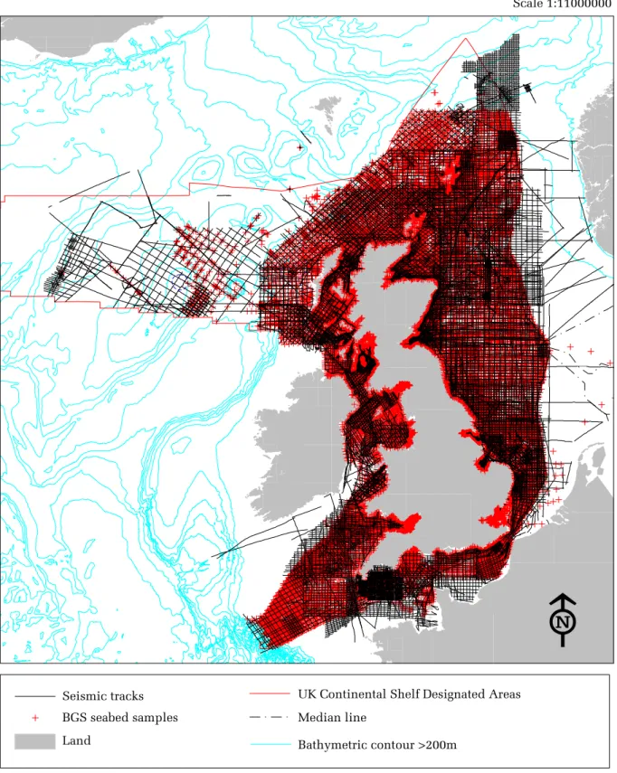
Figure 2.2 BGS survey (seabed sampling and seismic)
coverage around the UK
Scale 1:11000000
The exact limits of the UK Continental Shelf are set out in orders made under section 1(7) of the
Continental Shelf Act 1964 (© Crown Copyright).
Bathymetric contour >200m
Land
Median line
UK Continental Shelf Designated Areas
BGS seabed samples
Seismic tracks
BGS survey points and seismic tracks © NERC (Licence No. 2002/85).
IRISH
SEA
WALES
ENGLISH
CHANNEL
ENGLAND
FRANCE
NORTH SEA
Figure 2.3 Sandy sediment in less than 20 m water depth in
UK offshore waters
Scale 1:3500000
World Vector Shoreline © US Defense Mapping Agency.
Bathymetry © GEBCO Digital Atlas, British Oceanographic Data Centre on behalf of IOC and IHO 1994 & 1997.
Sandy sediment in less than 20 m water depth
In UK offshore waters
In UK inshore and non-UK waters
Bathymetric contour >200 m
Median line
Isle of Man 12 nm Territorial Sea
UK 12 nm Territorial Seas
UK Continental Shelf Designated Areas
Land
Seabed habitat derived from BGS 1:250,000 seabed sediment maps © NERC (Licence No. 2002/85).
Natura 2000 in UK Offshore Waters
The exact limits of the UK Continental Shelf are set out in orders made under section 1(7) of the
Continental Shelf Act 1964 (© Crown Copyright).
N.B. In UK inshore and non-UK waters only
areas of sandy sediment contiguous with
Norfolk Sandy
Mounds
Haddock
Bank
ENGLAND
North Norfolk Sandbanks
NORTH SEA
Indefatigable
Banks
Haisborough Tail,
Hewett Ridges &
Smith’s Knoll
Dogger Bank
Figure 2.4 Sandy sediment in less than 20 m water depth in
UK offshore waters off the Norfolk coast
Scale 1:1500000
World Vector Shoreline © US Defense Mapping Agency.
Bathymetry © GEBCO Digital Atlas, British Oceanographic Data Centre on behalf of IOC and IHO 1994 & 1997.
Sandy sediment in less than 20 m water depth
In UK offshore waters
In UK inshore and non-UK waters
UK 12 nm Territorial Seas
UK Continental Shelf Designated Areas
Land
Seabed habitat derived from BGS 1:250,000 seabed sediment maps © NERC (Licence No. 2002/85).
The exact limits of the UK Continental Shelf are set out in orders made under section 1(7) of the
Continental Shelf Act 1964 (© Crown Copyright).
N.B. In UK inshore and non-UK waters only
areas of sandy sediment contiguous with
those in UK offshore waters are shown.
Sandy sediment in less than 20 m water depth
In UK offshore waters
In UK inshore and non-UK waters
Median line
UK 12 nm Territorial Seas
UK Continental Shelf Designated Areas
Land
Outer Thames
Estuary Banks
ENGLAND
Bassurelle
ENGLISH
CHANNEL
Inner
Gabbard
North Falls
Galloper
South Falls
Sandettie
FRANCE
2XWHU*DEEDUG
BELGIUM
SOUTHERN
NORTH SEA
World Vector Shoreline © US Defense Mapping Agency.
Bathymetry © GEBCO Digital Atlas, British Oceanographic Data Centre on behalf of IOC and IHO 1994 & 1997.
N.B. In UK inshore and non-UK waters only areas of sandy sediment contiguous with those in
UK offshore waters are shown.
Figure 2.5 Sandy sediment in less than 20 m water depth in the
outer Thames Estuary and eastern English Channel
Scale 1:1400000
The exact limits of the UK Continental Shelf are set out in orders made under section 1(7) of the
Continental Shelf Act 1964 (© Crown Copyright).
Natura 2000 in UK Offshore Waters
Seabed habitat derived from BGS 1:250,000 seabed sediment maps © NERC (Licence No. 2002/85).
"
NORTH WEST
ENGLAND
King William Bank
Sandy Mound
ISLE OF
MAN
World Vector Shoreline © US Defense Mapping Agency.
Bathymetry © GEBCO Digital Atlas, British Oceanographic Data Centre on behalf of IOC and IHO 1994 & 199
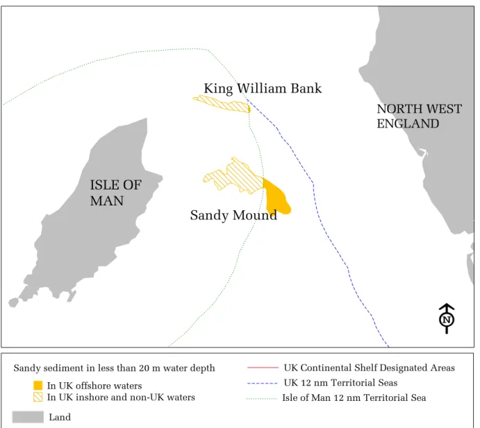
Figure 2.6 Sandy sediment in less than 20 m water depth
in UK offshore waters north-east of the Isle of Man
Scale 1:650000
The exact limits of the UK Continental Shelf are set out in orders made under section 1(7) of the
Continental Shelf Act 1964 (© Crown Copyright).
Sandy sediment in less than 20 m water depth
In UK offshore waters
In UK inshore and non-UK waters
Isle of Man 12 nm Territorial Sea
UK 12 nm Territorial Seas
UK Continental Shelf Designated Areas
Land
Seabed habitat derived from BGS 1:250,000 seabed sediment maps © NERC (Licence No. 2002/85).
"
N.B. In UK inshore and non-UK waters only areas of sandy sediment contiguous with those in
UK offshore waters are shown.
Natura 2000 in UK Offshore Waters
Plate 2.1 Possible Annex I reef habitat from south-western UK offshore waters at Haig Fras (photos: Ivor Rees, Dept. of Ocean Sciences, University of Wales, Bangor). (a) Biotope dominated by jewel anemone (Corynactis viridis) (b) Biotope dominated by Devonshire cup coral (Caryophyllia smithii) (c) Biotope characterised by cup sponges and erect branching sponges.
Plate 2.2 Possible Annex I bedrock reef habitat at approximately 130 m depth in north western UK offshore waters at Stanton Banks (Photo: British Geological Survey).
Natura 2000 in UK Offshore Waters
Plate 2.3 Possible iceberg ploughmark Annex I reef habitat at Wyville-Thomson Ridge (Photos: Brian Bett, Southampton Oceanography Centre).
Plate 2.4 Possible cold water coral (Lophelia pertusa) Annex I reef habitat at Darwin Mounds (Photos: Brian Bett, Southampton Oceanography Centre).
▲
▲
FAEROE ISLANDS
ROCKALL
SCOTLAND
SHETLAND
ISLANDS
NORWAY
NORTH
SEA
Figure 2.7 Potential Annex I reef habitat in UK offshore waters (northern section)
Scale 1:7000000
World Vector Shoreline © US Defense Mapping Agency. Bathymetry © GEBCO Digital Atlas, British Oceanographic Data Centre on behalf of IOC and IHO 1994 & 1997.
Seabed habitat derived from BGS 1:250,000 seabed sediment maps © NERC (Licence No. 2002/85).
N
a
tu
ra
2000 i
n
U
K
O
ff
shor
e
Wat
er
s
▲
Potential reef habitat
In UK offshore waters
In UK inshore and non-UK waters
Bathymetric contour >200 m
Median line
UK 12 nm Territorial Seas
UK Continental Shelf Designated Areas
Land
Potential reef habitat (point location)
The exact limits of the UK Continental Shelf are set out in orders made under section 1(7) of the Continental Shelf Act 1964 (© Crown Copyright).
N.B. In UK inshore and non-UK waters
only areas of potential reef habitat contiguous
with those in UK offshore waters are shown.
WALES
ENGLAND
ENGLISH CHANNEL
NORTH
SEA
NETHERLANDS
BELGIUM
FRANCE
World Vector Shoreline © US Defense Mapping Agency.
Bathymetry © GEBCO Digital Atlas, British Oceanographic Data Centre on behalf of IOC and IHO 1994 & 1997.
Figure 2.8 Potential Annex I reef habitat in UK offshore
waters (south-east section)
Scale 1:3750000
The exact limits of the UK Continental Shelf are set out in orders made under section 1(7) of the
Continental Shelf Act 1964 (© Crown Copyright).
Potential reef habitat
In UK offshore waters
In UK inshore and non-UK waters
Bathymetric contour >200 m
Median line
UK 12 nm Territorial Seas
UK Continental Shelf Designated Areas
Land
Region which may contain
Sabellaria spinulosa reef
Seabed habitat derived from BGS 1:250,000 seabed sediment maps © NERC (Licence No. 2002/85).
N.B. In UK inshore and non-UK waters only areas of potential reef habitat contiguous with those in
UK offshore waters are shown.
IRELAND
CELTIC SEA
SOUTH WEST
APPROACHES
WALES
IRISH
SEA
ENGLAND
FRANCE
Figure 2.9 Potential reef habitat in UK offshore waters
(south-west section)
Scale 1:3500000
World Vector Shoreline © US Defense Mapping Agency.
Bathymetry © GEBCO Digital Atlas, British Oceanographic Data Centre on behalf of IOC and IHO 1994 & 1997.
Potential reef habitat
In UK offshore waters
In UK inshore and non-UK waters
Bathymetric contour >200 m
Median line
Isle of Man 12 nm Territorial Sea
UK 12 nm Territorial Seas
UK Continental Shelf Designated Areas
Land
Seabed habitat derived from BGS 1:250,000 seabed sediment maps © NERC (Licence No. 2002/85).
Natura 2000 in UK Offshore Waters
The exact limits of the UK Continental Shelf are set out in orders made under section 1(7) of the
Continental Shelf Act 1964 (© Crown Copyright).
N.B. In UK inshore and non-UK waters only
areas of potential reef habitat contiguous with
those in UK offshore waters are shown.
World Vector Shoreline © US Defense Mapping Agency.
Bathymetry © GEBCO Digital Atlas, British Oceanographic Data Centre on behalf of IOC and IHO 1994 & 1997.
Figure 2.10 Potential distribution of Lophelia pertusa in the
north-east Atlantic (courtesy of Brian Bett,
Southampton Oceanography Centre)
6FDOH
The exact limits of the UK Continental Shelf are set out in orders made under section 1(7) of the
Continental Shelf Act 1964 (© Crown Copyright).
Lophelia pertusa
Area of potential occurrence
Unlikely to occur (Arctic water masses)
Bathymetric contour >200 m
Land
UK 12 nm Territorial Seas
UK Continental Shelf Designated Areas
Offshore of
Humber
ENGLAND
NETHERLANDS
Licence Area
401/2
BELGIUM
Dogger Bank
Gravel
Figure 2.11 Potential Annex I reef habitat in UK offshore
waters of the North Sea
Scale 1:2500000
World Vector Shoreline © US Defense Mapping Agency.
Bathymetry © GEBCO Digital Atlas, British Oceanographic Data Centre on behalf of IOC and IHO 1994 & 1997.
Potential reef habitat
In UK offshore waters
In UK inshore and non-UK waters
Median line
UK 12 nm Territorial Seas
UK Continental Shelf Designated Areas
Land
Region which may contain
Sabellaria spinulosa reef
Seabed habitat derived from BGS 1:250,000 seabed sediment maps © NERC (Licence No. 2002/85).
Natura 2000 in UK Offshore Waters
The exact limits of the UK Continental Shelf are set out in orders made under section 1(7) of the
Continental Shelf Act 1964 (© Crown Copyright).
"
N.B. In UK inshore and non-UK waters only
areas of potential reef habitat contiguous with
those in UK offshore waters are shown.
ENGLAND
Western English Channel
ENGLISH CHANNEL
Median Deep
Eastern English Channel Basin
FRANCE
World Vector Shoreline © US Defense Mapping Agency.
Bathymetry © GEBCO Digital Atlas, British Oceanographic Data Centre on behalf of IOC and IHO 1994 & 1997.
Figure 2.12 Potential Annex I reef habitat in UK offshore
waters in the English Channel
Scale 1:2000000
The exact limits of the UK Continental Shelf are set out in orders made under section 1(7) of the
Continental Shelf Act 1964 (© Crown Copyright).
Potential reef habitat
In UK offshore waters
In UK inshore and non-UK waters
UK 12 nm Territorial Seas
UK Continental Shelf Designated Areas
Land
Seabed habitat derived from BGS 1:250,000 seabed sediment maps © NERC (Licence No. 2002/85).
"
N.B. In UK inshore and non-UK waters only areas of potential reef habitat contiguous with those in
UK offshore waters are shown.
CELTIC SEA
Haig Fras
South West Approaches
Shelf Break
SW
ENGLAND
Western English
Channel
ENGLISH CHANNEL
FRANCE
World Vector Shoreline © US Defense Mapping Agency.
Bathymetry © GEBCO Digital Atlas, British Oceanographic Data Centre on behalf of IOC and IHO 1994 & 1997.
Figure 2.13 Potential Annex I reef habitat in UK offshore
waters in the Celtic Sea and South-west Approaches
Scale 1:4000000
The exact limits of the UK Continental Shelf are set out in orders made under section 1(7) of the
Continental Shelf Act 1964 (© Crown Copyright).
Potential reef habitat
In UK offshore waters
In UK inshore and non-UK waters
Bathymetric contour >200 m
UK 12 nm Territorial Seas
UK Continental Shelf Designated Areas
Land
Natura 2000 in UK Offshore Waters
Seabed habitat derived from BGS 1:250,000 seabed sediment maps © NERC (Licence No. 2002/85).
N.B. In UK inshore and non-UK waters only areas of potential reef habitat contiguous with those
in UK offshore waters are shown.
Mid-Irish Sea
Cardigan Bay
ISLE OF
MAN
West of
Isle of Man
N.
IRELAND
North of Anglesey
WALES
ENGLAND
Figure 2.14 Potential Annex I reef habitat in UK offshore waters
in the Irish Sea
Scale 1:1500000
World Vector Shoreline © US Defense Mapping Agency.
Bathymetry © GEBCO Digital Atlas, British Oceanographic Data Centre on behalf of IOC and IHO 1994 & 199
Potential reef habitat
In UK offshore waters
In UK inshore and non-UK waters
Bathymetric contour >200 m
Isle of Man 12 nm Territorial Sea
UK 12 nm Territorial Seas
UK Continental Shelf Designated Areas
Land
Seabed habitat derived from BGS 1:250,000 seabed sediment maps © NERC (Licence No. 2002/85).
The exact limits of the UK Continental Shelf are set out in orders made under section 1(7) of the
Continental Shelf Act 1964 (© Crown Copyright).
N.B. In UK inshore and non-UK waters only
areas of potential reef habitat contiguous with
those in UK offshore waters are shown.
Iceberg Ploughmarks
(Hebrides Slope section)
ST
KILDA
Hebrides Shelf
LEWIS
SKYE
SCOTLAND
Stanton Banks
Blackstones
Banks
World Vector Shoreline © US Defense Mapping Agency.
Bathymetry © GEBCO Digital Atlas, British Oceanographic Data Centre on behalf of IOC and IHO 1994 & 1997.
Figure 2.15 Potential Annex I reef habitat in UK offshore
waters west of Scotland
Scale 1:2000000
The exact limits of the UK Continental Shelf are set out in orders made under section 1(7) of the
Continental Shelf Act 1964 (© Crown Copyright).
Potential reef habitat
In UK offshore waters
In UK inshore and non-UK waters
Bathymetric contour >200 m
UK 12 nm Territorial Seas
UK Continental Shelf Designated Areas
Land
Natura 2000 in UK Offshore Waters
Seabed habitat derived from BGS 1:250,000 seabed sediment maps © NERC (Licence No. 2002/85).
N.B. In UK inshore and non-UK waters only areas of potential reef habitat contiguous with those in
UK offshore waters are shown.
▲
George Bligh Bank
ROCKALL
Rockall
Bank
Anton Dohrn
Seamount
Rosemary Bank
Hebrides Terrace
Seamount
SKYE
Darwin Mounds
LEWIS
World Vector Shoreline © US Defense Mapping Agency.
Bathymetry © GEBCO Digital Atlas, British Oceanographic Data Centre on behalf of IOC and IHO 1994 & 199
Figure 2.16 Potential Annex I reef habitat in UK offshore
waters in the Rockall Trough and Rockall Bank region
Scale 1:3500000
The exact limits of the UK Continental Shelf are set out in orders made under section 1(7) of the
Continental Shelf Act 1964 (© Crown Copyright).
▲
Potential reef habitat
In UK offshore waters
In UK inshore and non-UK waters
Bathymetric contour >200 m
UK 12 nm Territorial Seas
UK Continental Shelf Designated Areas
Land
Potential reef habitat (point location)
Seabed habitat derived from BGS 1:250,000 seabed sediment maps © NERC (Licence No. 2002/85).
N.B. In UK inshore and non-UK waters only areas of potential reef habitat contiguous with those in
UK offshore waters are shown.
Natura 2000 in UK Offshore Waters
Potential reef habitat
In UK offshore waters
In UK inshore and non-UK waters
Bathymetric contour >200 m
UK 12 nm Territorial Seas
UK Continental Shelf Designated Areas
Mammal
Hatton Bank
Sandastre
Lyonesse
Swithin
Rockall
Bank
World Vector Shoreline © US Defense Mapping Agency.
Bathymetry © GEBCO Digital Atlas, British Oceanographic Data Centre on behalf of IOC and IHO 1994 & 1997.
N.B. In UK inshore and non-UK waters only areas of potential reef habitat contiguous with those in UK
offshore waters are shown.
Figure 2.18 Potential Annex I reef habitat in UK offshore
waters west of Rockall
Scale 1:2250000
The exact limits of the UK Continental Shelf are set out in orders made under section 1(7) of the
Continental Shelf Act 1964 (© Crown Copyright).
Seabed habitat derived from BGS 1:250,000 seabed sediment maps © NERC (Licence No. 2002/85).
▲
▲
Darwin
Mounds
FAEROE
ISLANDS
Solan Bank
Judd Deeps
Wyville Thomson
Ridge
ORKNEY
ISLANDS
Turbot and
Otter Bank
Iceberg ploughmarks
Shetland Slope and
Wyville Thomson
Ridge section
SHETLAND
ISLANDS
Shetland
Islands
World Vector Shoreline © US Defense Mapping Agency.
Bathymetry © GEBCO Digital Atlas, British Oceanographic Data Centre on behalf of IOC and IHO 1994 & 1997.
Figure 2.19 Potential Annex I reef habitat in UK offshore
waters north of Scotland
Scale 1:3450000
The exact limits of the UK Continental Shelf are set out in orders made under section 1(7) of the
Continental Shelf Act 1964 (© Crown Copyright).
▲
Potential reef habitat
In UK offshore waters
In UK inshore and non-UK waters
Bathymetric contour >200 m
UK 12 nm Territorial Seas
UK Continental Shelf Designated Areas
Land
Potential reef habitat (point location)
Natura 2000 in UK Offshore Waters
Seabed habitat derived from BGS 1:250,000 seabed sediment maps © NERC (Licence No. 2002/85).
N.B. In UK inshore and non-UK waters only areas of potential reef habitat contiguous with those
in UK offshore waters are shown.
▲
Bathymetric contour >200 m
UK 12 nm Territorial Seas
UK Continental Shelf Designated Areas
Land
Pockmark field
Oil & Gas licensing block 16/3
’Scanner’ pockmark
▲
Witch Ground
Fladen Ground
CENTRAL NORTH SEA
SCOTLAND
SHETLAND
ISLANDS
Forties
Field
World Vector Shoreline © US Defense Mapping Agency.
Bathymetry © GEBCO Digital Atlas, British Oceanographic Data Centre on behalf of IOC and IHO 1994 & 1997.
Figure 2.20 Pockmark fields and other areas within which
submarine structures made by leaking gases
Annex I habitat may occur
Scale 1:2000000
The exact limits of the UK Continental Shelf are set out in orders made under section 1(7) of the
Continental Shelf Act 1964 (© Crown Copyright).
Seabed habitat derived from BGS 1:250,000 seabed sediment maps © NERC (Licence No. 2002/85).