A FRAMEWORK FOR
LAND USE MAPPING
Mapping appropriate land use and reducing land use change
impacts in the context of the Renewable Energy Directive
REPORT PRODUCED BY
2013
FINAL REPORT
1| IEEP Land use mapping methodology
Disclaimer: The arguments expressed in this report are solely those of the authors, and do not reflect the opinion of any other party. Any errors that remain in the report are the responsibility of the authors.
To be quoted as: Kretschmer, B., Allen, B. and Tucker, G. (2013) A Framework for Land Use Mapping: Mapping appropriate land use and reducing land use change impacts in the context of the Renewable Energy Directive. Institute for European Environmental Policy (IEEP): London.
Acknowledgements: Funding from WWF Germany under the Sustainable Land Use project (SuLu) is gratefully acknowledged. The SuLu project is financially supported by the
About this Report
Publisher WWF Deutschland Publication date February 2013
Authors Bettina Kretschmer, Ben Allen and Graham Tucker (IEEP) Contact [email protected]
Layout Ingo Stöcklin
Picture credits Brent Stirton / Getty Images / WWF-UK
Institute for European Environmental Policy London Office
15 Queen Anne's Gate London, SW1H 9BU Tel: +44 (0) 20 7799 2244 Fax: +44 (0) 20 7799 2600 Brussels Office Quai au Foin, 55 Hooikaai 55 B- 1000 Brussels Tel: +32 (0) 2738 7482 Fax: +32 (0) 2732 4004
The Institute for European Environmental Policy (IEEP) is an independent not-for-profit institute which both has its own research programmes and undertakes work for external sponsors in a range of policy areas. For further information see our website at http://www.ieep.eu.
Contents
EXECUTIVE SUMMARY 5
1 Introduction 7
1.1 Context of the work 8
1.2 Aims of the study 10
2 The RED sustainability requirements and
their implementation 13
3 Review of mapping initiatives 17
4 Proposed framework and criteria for using maps to
support sustainable biofuel production and other land uses 19 4.1 Principles to guide environmentally responsible
land use planning 19
4.2 The potential contribution of different land use planning
approaches to supporting sustainable biofuel production 23
4.3 Criteria for establishing if maps are fit for purpose 31
5 The potential assessment process by the
European Commission 41
5.1 The role of the Commission in assessing
maps and its challenges 41
5.2 A potential step-wise approach to assess maps 42
6 Mitigating ILUC 45
6.1 Literature review – Overview and assessment
of mitigation options 46
6.2 Protecting biodiversity and high carbon stock land? 49
IEEP Land use mapping methodology| 3
REFERENCES 55
Annex 1: Protected Area definitions 59
Annex 2: Areas considered to be of high conservation value
by governmental and non-governmental organisations 61
A 2.1 International 61
A 2.2 Regional 64
A 2.3 National lists 65
Annex 3: Initiatives to support the implementation
of land use sustainabilty schemes 67
A 3.1 High Conservation Value approach 67
A 3.2 Local Ecological Footprinting Tool (LEFT) 69
A 3.4 Eyes on the forest 72
A 3.3 International Biodiversity Assessment Tool for business
(IBAT for business) 71
Annex 4: Mapping approaches and other initiatives relevant
to the cultivation of biofuel crops 75
A 4.1 Responsible Cultivation Areas (RCA) 75
A 4.2 SuLu project 76
A 4.3 Agri-ecological zoning for sugarcane
expansion in Brazil: ZAE Cana 81
A 4.4 RTRS broad scale maps and HCV guidance for soy expansion: Multi-stakeholder process
(Roundtable on Responsible Soy, RTRS) 83
A 4.5 BioCarbon tracker 85
A 4.6 Potico Project (World Resources Institute (WRI) 86
Annex 5: Summary of Review of tools and methods by Böttger (2011) 91 Annex 6: Proposed procedure for operationalizing the RED
sustainability criteria for highly biodiverse grasslands 95 Annex 7: Satellite Data Resources for WWF –
TABLE OF FIGURES
Figure 1: Example of an indicative map of forest area loss from the World Resources
Institute's Forest Cover Analyzer 24
Figure 2: IUCN's proposed common approach for land-use planning 29 Figure 3: A proposed land use planning and control framework for ensuring
compliance with environmental sustainability criteria for biofuels 30 Figure 4: Summary of KBA criteria and thresholds from (Langhammer et al, 2007) 62 Figure 5: Relationship between IBAs, KBAs and AZE sites (Langhammer et al, 2007) 62
Figure 6: Overview of data used to map EU RED criteria 78
Figure 7: ZAE Cana methodological process 82
Figure 8: Evaluation of selected methodologies (Böttger, 2011, p20) 92 Figure 9: Assessment of methods in a portfolio according to compliance of
RED-requirements and applicability and cost-benefit-ratio (Böttger, 2011, p21) 93 Figure 10: A three level decision structure - a basis for assessment 99
IEEP Land use mapping methodology| 5
EXECUTIVE SUMMARY
This report contributes to the WWF Sustainable Land Use (SuLu) Project, by providing policy and methodological guidance for the mapping of appropriate land use that aims to ensure the production of sustainable biofuel feedstocks with minimal environmental impacts. This is to support a broad range of ongoing and future biofuel related land use mapping initiatives. It also makes specific recommendations to the European Commission on how to assess land use planning maps, were these are submitted by certification schemes as evidence of compliance with sustainability criteria contained within the EU’s Renewable Energy Directive (RED). In addition the report addresses the suitability of land use planning as a tool to mitigate indirect land use change (ILUC).
There are a number of ways in which land use maps and surveys can be used to help reduce environmental impacts of biofuels (and potentially other commodities) by ensuring compliance with sustainability criteria, for example those in the RED. A range of
overlapping and interacting approaches could be envisaged which are grouped into three broad categories of approaches:
• Indicative guidance maps provide information on environmental status and values (eg protected areas, biodiversity values), without making explicit judgements on the whether biofuels should be produced in a specific location.
• Definitive compliance maps (potentially including areas of uncertain status or specified risk status) aim to ensure compliance with defined sustainability standards such as those of the RED or other voluntary criteria.
• On-site assessments, eg as the basis for a comprehensive simple project-level approach to the accreditation of biofuel production.
Considering the relative advantages and disadvantages of the different approaches (Section 4.2), it is clear that they are likely to form part of a process that evolves from coarse indicative mapping, complemented by information gained from on-site assessments, to more detailed risk maps or even definitive compliance maps.
In order to ensure environmentally responsible land use planning, we recommend that the following principles should be followed by map developers (Section 4.1):
• Application of the precautionary principle, which is a basic requirement for EU environmental policy, an important aspect of it being that the proponent of an activity should bear the burden of proof with regard to resolving uncertainty over possible impacts.
• Assessments need to be based on data that are fit for their purpose (Section 4.3). • Adherence to the ecosystem approach, which most importantly for this study calls
for a participatory process involving all key stakeholders, with decisions made at the lowest appropriate level.
• Definitive compliance maps require endorsement from competent environmental authorities, as it is very difficult for external organisations such as the European Commission to independently conduct such assessments.
• Environmental information and decisions made on the acceptability of biofuel production need to be transparent and open to public scrutiny.
As part of this process, we recommend the following criteria to establish whether maps are fit for purpose (Section 4.3), reflecting eight general considerations (presented without any indication of order or importance):
• Scope and definitions: the different definitions of land related sustainability criteria, such as those of the RED, have been considered and mapped in accordance with the Directive.
• Data sources and description: meta-data are provided to understand the different data sources on which maps are developed and their suitability.
• Process and methodology: the methodological approach used to process and combine data and produce the final map(s) is clearly described.
• Data resolution: this is adequate to determine whether land related sustainability criteria can be reliably assessed from the map.
• Time period covered: cut-off dates, eg as set out in the RED, are adhered to, and the most up to date data are used in the assessment of land related sustainability criteria.
• Area covered by the map: the maps show the total area of land affected by the proposed scheme and any incidental impacts outside the area of cultivation. • Data validation and accuracy: data are validated and cross checked during the
production of the map.
• Official endorsement: the map is endorsed by the relevant responsible environmental authority, in consultation with appropriate environmental data holders and other environmental stakeholders.
Voluntary certification schemes that can be used by biofuel producers and other economic operators to demonstrate compliance with the RED sustainability criteria could decide to use maps as part of the compliance process. Such maps would be submitted for recognition to the European Commission. The assessment by the Commission would depend on the purpose of the maps, eg indicative versus definitive compliance maps; a rigorous step wise assessment procedure for the latter type is recommended that would involve environmental authorities in biofuel producing countries (Section 5).
Robust maps developed in line with the recommended principles and criteria may be a way to mitigate indirect land use change (ILUC) from biofuel production (Section 6). This is only the case, however, when such maps are applied to the wider agricultural sector and
developed in a sufficient number of countries. For land use planning to indeed become a powerful tool, several hurdles need to be overcome, related to governance structures in the land use sector, the practical challenges of land zoning and sufficient monitoring and surveillance to enforce land zoning decisions.
IEEP Land use mapping methodology| 7
1 INTRODUCTION
1.1 Context of the work
The EU Renewable Energy Directive (RED)1 has established ambitious targets for the use of renewable energy in the EU Member States. In the particular context of transport, it has introduced a binding target of 10 per cent renewable energy use in transport to be met in each Member State by the year 2020. According to analyses of the National Renewable Energy Action Plans (NREAPs) that Member States had to submit to the Commission by June 2010, first-generation biofuels, for which feedstocks are often grown in competition with food and feed crop production, will make up 90 per cent of the volume needed to meet this target. Bioenergy sources overall are anticipated to contribute around half to meeting the RED’s overall 20 per cent renewable energy share to be reached by the EU in 20202.
In order to deal with the environmental sustainability challenges of growing crops for biofuel and bioliquids production, the RED includes a sustainability scheme (see section 2) setting out requirements in relation to GHG savings and areas valued for their biodiversity and carbon stocks. The European Commission (in particular DG ENER, responsible for the file together with DG CLIMA) is still in the process of operationalizing elements of the biofuel sustainability criteria.
To deliver effective regulation it is not sufficient simply to set out the criteria to be met; mechanisms for implementation, enforcement and verification of compliance also are necessary (Bowyer et al, 2010). Article 18 of the RED specifies the mechanisms for verifying the compliance of biofuels placed on the EU market by economic operators with the sustainability criteria (that are set out in Article 17).
For biofuels to count towards the RED targets or be eligible for financial support, economic operators must demonstrate to the relevant Member State that the RED’s sustainability criteria are being complied with. Under the Directive, Member States are required to adopt measures to ensure economic operators submit reliable information on compliance. Member States may also request the data used to develop this information or proof. The information provided by the economic operator must have been independently audited, prior to submission to the Member State, to ensure evidence is accurate, reliable and protected against fraud.
To assist economic operators in developing an evidence base and demonstrating
compliance, Article 18 specifies several ways in which compliance can be proven, which are further elaborated in the next section, one of them being through the use of national or international voluntary certification schemes that set standards for biomass production and are recognised by the European Commission to meet adequate standards of reliability,
1 Directive 2009/28/EC of the European Parliament and of the Council of 23 April 2009 on the promotion of
the use of energy from renewable sources and amending and subsequently repealing Directives 2001/77/EC and 2003/30/EC,
http://eur-lex.europa.eu/LexUriServ/LexUriServ.do?uri=OJ:L:2009:140:0016:0062:EN:PDF
transparency and independent auditing. A first batch of seven certification schemes under which economic operators may seek recognition as a way to demonstrate compliance with the RED’s sustainability criteria for biofuels and bioliquids were approved by the
Commission in July 2011. Further schemes have been recognised since then and this process continues. The schemes constitute an important step in making the sustainability scheme operational. At the time of writing, the Commission is still expected to clarify some of the standards that need to be met with respect to the biodiversity criteria (ie in relation to highly biodiverse grasslands one of the principal habitat types on which feedstocks should not be grown if they are to comply with the Directive).
According to a communication by the Commission (2010/C 160/01), it is envisaged under the RED that certification schemes (‘voluntary schemes’) may use geographical maps as the basis for demonstrating compliance with the RED criteria3. This could result in reliance on strategic land use planning approaches whereby maps may:
• Provide positive guidance for biofuel producers on appropriate (in the sense of the RED) biofuel raw material cultivation areas;
• Trigger national land use planning processes protecting sites beyond the biofuel sector (long-term goal), which would help to avoid wider indirect land use change (ILUC) impacts.
There are a range of approaches to land use planning (see for example GIZ, 2011) and maps could contribute to them in a variety of ways. However, in this study we recognise and focus on the following potentially overlapping and interacting land use planning elements as follows:
1) Definitive compliance maps that aim to reliably and definitively identify and delineate areas that are compliant with RED criteria (or other land use
sustainability criteria) and are hence suitable in this respect for biofuel feedstock cultivation. Such maps are sometimes called ‘go / no-go’ maps. For example, with respect to RED criteria, no-go areas would include protected areas, primary forest and other forested land, biodiverse grasslands, wetlands and peatlands. However, the mapping of ‘go’ areas is potentially misleading because it could be interpreted as a recommendation that biofuels should be grown in an area, whereas in fact it only refers to compliance with a limited set of environmental criteria. Therefore, to avoid such misunderstandings, we now recommend that definitive compliance maps should not refer to ‘go areas’ unless the maps are based on a comprehensive assessment of all relevant considerations, including social as well as environmental issues.
2) Indicative guidance maps that provide information to biofuel producers, authorities and other interested parties on which areas of land should probably be avoided to ensure compliance with sustainability criteria, and which may be worth
3 See also section 5.1. The relevant quote from Communication 2010/C 160/01: ‘“Non- typical” schemes may
have different forms such as maps showing that certain geographical areas are compliant or not compliant with the criteria…’.
IEEP Land use mapping methodology| 9 investigating further as potential sites for biofuel feedstock cultivation. Such maps do NOT aim to demonstrate compliance with the RED land related criteria or other voluntary sustainability criteria per se.
3) On-site assessments, where maps and other data are unavailable or incomplete, or to check for the presence of high biodiversity habitats that are difficult to identify from remote sensing and other central data sources (eg highly biodiverse grasslands that should be protected under the RED).
There are of course other potential variations on the above framework and types of approach. For example risk maps might indicate areas in which the production of biofuel feedstocks would definitely not be compliant with sustainability criteria (ie are ‘no-go areas’), areas that are of medium risk of contravening criteria (and might require a site survey to assess their suitability) and areas that are of low risk and probably the best areas to further investigate. Furthermore, as discussed later in section 0 it is logical to use the approaches in combination. However, for the purposes of this report we refer to the three distinct approaches above.
There is an opportunity to support the work of the Commission and the establishment of sustainability schemes that would help to ensure that the biodiversity criteria (and other environmental criteria) are fully complied with through the implementation of robust and transparent procedures that involve all appropriate stakeholders and use the best available up-to-date data.
There are currently a number of initiatives underway that are studying options or attempting to operationalize the sustainability criteria in practice; these are reviewed in section 2. One initiative to develop risk maps is the WWF Germany led SuLu (Sustainable Land Use) land use mapping project that is being developed by WWF in collaboration with partners (governmental and non-governmental) in Indonesia, Brazil and Colombia4. One of the potential outcomes of the project is to have the maps, which could classify areas into EU RED no-go as well as high-, medium- and low-risk areas5 (which are not covered by the EU RED), used by voluntary schemes or biofuels producers as evidence towards demonstrating RED compliance.
Many initiatives are drawing on lists and maps of protected areas and various assessments of the biodiversity conservation of potential production areas (irrespective of their protection status). But this in itself is not straightforward as a variety of approaches, indicators, criteria and standards have been used by different institutions to evaluate and identify areas that are considered to be of high priority for biodiversity conservation (see Annex 2). There are also differing definitions of protected areas even in the same apparent category and often incomplete and non-standardised inventories (see Annex 1). It is therefore important to ensure that biofuel suitability maps use appropriate definitions of
4 ‘Global Land Use and Sustainable Biomass Production’ project: http://www.globallandusechange.org/. 5 The SuLu project is ongoing and will be subject to changes, the final definition and naming of categories is
protected areas and maps of protected area boundaries that are recognised by national competent (ie responsible) environmental authorities.
The RED sustainability criteria under Article 17 3(b)(ii) aim to protect sites that are listed ‘by intergovernmental organisations or the International Union for the Conservation of Nature’. Therefore, Ramsar Sites, Biosphere Reserves and World Heritage Sites for example should all clearly be ‘no-go areas’. Although IUCN has developed criteria for defining protected areas and a typology for protected areas (Dudley, 2008) they have not directly identified sites themselves. Therefore the IUCN component of Article 17(3)(b)(ii) is in practice non-operational at the moment. However, IUCN and others are currently developing the Key Biodiversity Area (KBA) concept (see Annex 2) and may in future endorse lists of KBAs. IUCN listed KBAs presumably would then be protected under the RED (subject to recognition by the European Commission).
One particular challenge relates to the operationalisation of the sustainability criteria for highly biodiverse grasslands (which have still to be defined further by the Commission under the Comitology Procedure). Recent studies have suggested that the mapping of natural grasslands should be feasible (White et al, 2000), but defining and mapping other highly biodiverse grasslands will be very difficult. It is likely that some form of evaluation framework that combines the approaches listed above will therefore be necessary (see Annex 4 for the summary of an approach proposed by IEEP).
Given the variety of approaches and datasets that are being used (and their limitations) it is particularly important to consider how maps or on-site assessments of RED compatibility could be used by biofuel producers and within-country environmental authorities, and how they would be assessed by the Commission.
1.2 Aims of this study
The overall objective of this project is to support the SuLu project by developing a reliable methodology for the mapping of appropriate land uses that is likely to be compatible with RED requirements, and to assess the relative merit of land use mapping for reducing indirect land use change impacts6.
This overall objective can be broken down into three tasks that also determine the structure of this report:
1) Identification of principles and criteria that land use planning maps need to adhere to so as to be deemed reliable and effective in protecting areas of high value for biodiversity and ecosystem services as well as for carbon stocks. This includes a review of the mapping within the SuLu project as well as a review of the methodology work that has been undertaken in the SuLu project; as well as a review of other ongoing mapping processes and other tools to identify areas of conservation interest.
6 The findings of a draft version of the report provided a background for a Knowledge Café organised by IEEP at the IUCN World Congress in Korea in September 2012. The event was designed to identify lessons learnt from initiatives that aim to use land use mapping and certification schemes to limit direct and indirect biodiversity and ecosystem service impacts from the production of biofuels, biomass and other agricultural commodities.
IEEP Land use mapping methodology| 11 2) Consideration of potential ways of integrating land use planning maps and on-site
assessments in the political process, eg in order to demonstrate compliance with the RED land use criteria. This focuses on the use of maps in an EU policy context and also considers whether and how maps could be recognised by the European Commission.
3) Critical review of different approaches to mitigate ILUC with a focus on land use planning and the relative merits and shortcomings of this approach to mitigating ILUC.
Whilst the work under the first task has reviewed existing mapping initiatives, technical assessments of statistical, GIS and remote sensing methods used within different initiatives are not within the scope of the study. Instead the key aim is to draw on the experiences gained from existing initiatives to identify generally applicable principles and criteria that can provide guidance to future mapping activities as well as to policy makers assessing the quality of maps. This work is set within the context of providing biomass for sustainable biofuels. However, the resulting principles and methodology can be extended to other commodities, so as to demonstrate for example aspects of the sustainability of food and feed crops.
IEEP Land use mapping methodology| 13
2 THE RED SUSTAINABILITY REQUIREMENTS AND THEIR
IMPLEMENTATION
In order to ensure the sustainability of biofuels used to meet the 2020 10 per cent renewable energy in transport target under the RED as well as the 6 per cent reduction target for the lifecycle emissions of transport fuels spelled out in the Fuel Quality Directive (FQD)7, both directives contain sustainability criteria (see
Box 1: Overview mandatory sustainability criteria of the RED and FQD
). This section briefly introduces the criteria as well as the different ways in which economic operators in the biofuel supply chain can demonstrate compliance with the RED’s
sustainability criteria.
Box 1: Overview mandatory sustainability criteria of the RED and FQD
7 Directive 2009/30/EC of the European Parliament and of the Council of 23 April 2009 of 23 April
2009amending Directive 98/70/EC as regards the specification of petrol, diesel and gas-oil and introducing a mechanism to monitor and reduce greenhouse gas emissions,
http://eurlex.europa.eu/LexUriServ/LexUriServ.do?uri=OJ:L:2009:140:0088:0113:EN:PDF.
The RED’s mandatory sustainability scheme consists of three main building blocks of criteria that need to be adhered to in order to biofuels and bioliquids to be counted for the national renewable energy targets and to be eligible for financial support (RED Article 17(1)). These three elements are:
• A minimum GHG saving requirement (Art 17(2)). This is specified to be of at least 35 per cent. It will increase to 50 per cent from 2017 onwards and to 60% for new installations from 2018;
• Land requirements to prevent the use of raw material from land that was previously:
o of high biodiversity value (Art 17(3)); o high carbon stock (Art 17(4));
o peatland, unless evidence is provided that the cultivation and harvesting of that raw material does not involve drainage of previously undrained soil (Art 17(5));
• Sustainable biofuels must be traceable via a chain of custody based on a mass balance methodology (Art 18(1)).
The RED provides for different mechanisms of proving compliance with the sustainability criteria. These mechanisms are laid out in Article 18 of the RED and are further specified in a Communication on ‘voluntary schemes and default values’8. They include:
• National systems of ensuring compliance with the sustainability criteria whereby economic operators directly submit information to Member State authorities (Art 18.3);
• European Commission recognised voluntary national or international schemes (Art 18.4);
• Bilateral and multilateral agreements concluded by the European Union with third countries and recognized by the Commission for the purpose of the RED so that biofuel feedstocks grown within that country would be considered to comply with the Directive’s requirements (none at present, Art 18.4).
8 Communication from the Commission on voluntary schemes and default values in the EU biofuels and
bioliquids sustainability scheme (2010/C 160/01),
http://eur-lex.europa.eu/LexUriServ/LexUriServ.do?uri=OJ:C:2010:160:0001:0007:EN:PDF.
Article 17(3) states that biofuels and bioliquids shall not be made from raw material obtained from land with high biodiversity value. It then goes on to qualify this statement by clarifying that for the purposes of the Directive this means land that had one of the following statuses in or after January 2008, whether or not the land continues to have that status:
a) Primary forest and other wooded land b) Areas designated for nature protection c) Highly biodiverse grasslands that is:
(i) natural, namely grassland that would remain grassland in the absence of human intervention and which maintains the natural species composition and ecological characteristics and processes; or
(ii) non-natural, namely grassland that would cease to be grassland in the absence of human intervention and which is species-rich and not degraded, unless evidence is provided that the harvesting of the raw material is necessary to preserve its grassland status.
With regard to the specific provisions for high carbon stock land, Article 17(4) defines those as land that had one of the following statuses in January 2008 and no longer has that status:
(a) wetlands, namely land that is covered with or saturated by water permanently or for a significant part of the year;
(b) continuously forested areas, namely land spanning more than one hectare with trees higher than five metres and a canopy cover of more than 30 %, or trees able to reach those thresholds in situ;
(c) land spanning more than one hectare with trees higher than five metres and a canopy cover of between 10 % and 30 %, or trees able to reach those thresholds in situ, unless evidence is provided that the carbon stock of the area before and after conversion is such that, when the methodology laid down in part C of Annex V is applied, the conditions laid down in paragraph 2 of this Article would be fulfilled.
IEEP Land use mapping methodology| 15 Box 2 below summarises the key actors involved in the processes surrounding the
sustainability certification of biofuels. From informal exchanges, discussions and presentations with and by the Commission, it is apparent that the Commission has given considerable attention to the voluntary schemes option. The use of voluntary schemes is explicitly mentioned as a ‘[tool] designed to reduce the administrative burden for economic operators’9. Apart from providing a tool to assess the sustainability of biofuels imported from outside of the EU, the attractiveness of such schemes is that once recognized by the Commission, they must be recognized by all Member States as proof of compliance, hence facilitating intra-EU trade of sustainably produced biofuels as well as helping establish similar standards concerning the verification of sustainability across Member States.
A range of certification schemes has been developed over the last years for the purpose of the RED. At the same time, existing schemes (eg targeted at specific agricultural products and/or markets) have been developed further in order to make them ‘RED-compatible’. Voluntary schemes are recognised following a ‘comitology’ process by which the Commission issues an opinion as to whether or not to recognise a scheme. As part of an ‘advisory procedure’ the Commission’s opinion is referred to a Committee of Member State representatives to issue a (non-binding) opinion.
As of January 2013, the European Commission has officially recognised thirteen schemes following committee meetings of Member State representatives10. Section 5 introduces the way by which voluntary schemes may make use of geographical maps and how the EC could go about assessing such maps. The recognised schemes vary in their coverage of different biofuel pathways and geographical coverage. Some for instance only certify the supply chain of a specific biofuel pathway and/or of biofuels coming from certain producer countries. Others apply to all types of biofuels produced in all countries. Schemes may furthermore vary by the extent to which (if at all) they include criteria that go beyond the mandatory criteria of the RED (eg covering social sustainability issues). The approved schemes are:
• ISCC EU – German (government financed) scheme covering all types of biofuels; • Bonsucro EU – Roundtable initiative for sugarcane based biofuels, focused on
Brazil;
• RTRS EU RED – through the Roundtable on responsible soy, focus on Argentina and Brazil;
• RSB EU RED – Roundtable initiative covering all types of biofuels; • 2BSvs – French industry scheme covering all types of biofuels;
• RSBA – Industry scheme for biofuel producer Abengoa covering their supply chain;
• Greenergy – Industry scheme for Greenergy covering sugar cane ethanol from Brazil);
9 See Communication 2010/C 160/01. The same holds for bilateral or multilateral agreements between the EU and third countries. However, no such agreements have been concluded and recognised by the Commission for the purpose of the RED up to this date.
10 The list of recognised schemes is available at:
• Ensus – developed by UK bioethanol producer Ensus only covering bioethanol from EU feed wheat produced by Ensus itself;
• Red Tractor Crops and Sugar Beet Scheme – a UK Assured Food Standard derived scheme;
• SQC – Scottish Quality Farm Assured Combinable Crops scheme;
• Red Cert – German origin scheme previously recognised in Germany covering all types of biofuels;
• NTA 8080 – Dutch origin scheme previously recognised in the Netherlands covering all types of biofuels (and developed to also certify solid and gaseous biomass);
• RSPO RED – Roundtable on Sustainable Palm Oil adapted to suit RED requirements.
Box 2: Key actors in the biofuel certification processes
• European Commission – the Commission will be responsible for developing guidance in terms of the permitted actions on the part of Member States and their regulators. Moreover, they will importantly specify which voluntary schemes are deemed in compliance with EU requirements, which would include assessment of maps submitted by voluntary schemes.
• National regulators and competent authorities.
• Voluntary schemes – this broad heading encompasses assurance schemes that have set standards relevant to biofuel and agricultural production. This includes schemes that were developed with the purpose to assess biofuel sustainability in the line with the RED (eg ISCC, REDCert) and schemes that have been around for longer and are adapted to seek recognition under the RED (such as RSPO, Red Tractor).
• Standard setting bodies – these organisations specify detailed standards to be adopted in order to audit or verify compliance
• Certification and verification bodies – these organisations will be providing auditing services either to determine compliance with requirements by producers on the ground or to assess the compliance with standards along the supply chain. • Industry representatives – important groupings include farmer representatives,
product specific support groups for example focusing on the marketing and development of oilseeds or sugar products and fuel producer groups.
• Processing industry – including feedstock marketers, importers, fuel processors, oil seed crushers.
• Feedstock producers – including individual farmers, cooperatives and plantations. • Civil society – including local communities, environmental and social NGOs and
independent experts developing standards and approaches for assessing biofuel sustainability.
IEEP Land use mapping methodology| 17
3 REVIEW OF MAPPING INITIATIVES
This section summaries the review of approaches to identify areas of high biodiversity (see Annexes 3 and 4) and of existing initiatives that aim to map such areas, and others of relevance to environmental sustainability criteria, to plan and control the cultivation of areas for bioenergy crops in accordance with RED criteria and/or other sustainability criteria defined under the respective initiatives. The information gathered through this review is used to inform the proposed principles and criteria for developing map based approaches to establish suitable cultivation areas for bioenergy crops and the reduction of indirect land use change as a result of bioenergy production.
As mentioned above, the work of this project is rooted within the SuLu project led by WWF Germany and involving WWF partners in the study regions Indonesia and Colombia. The US based WWF Conservation Science Program (CSP) provides scientific oversight and technical expertise on Geographical Information Systems (GIS). IEEP have worked in collaboration with the SuLu project team11 experts to develop the principles and criteria set out under Section 4 to supplement the information found throughout a review of existing mapping approaches.
Acting through the sustainability criteria of the Renewable Energy Directive, SuLu is identifying the most important areas for the conservation of biodiversity and lands with high carbon stock value. They are working with stakeholders on the development of methods to identify no go (in the sense of breaching the RED sustainability criteria), high-, medium- and low-risk areas for sustainable biomass production. The project uses
geographic techniques to define and communicate RED requirements and to integrate advanced landscape analysis into spatial planning with local stakeholders (further details of the work can be found in Annex A4.2).
Ten existing mapping initiatives were identified as relevant to this study and can be broadly grouped as follows:
• Those approaches that use geographic data in order to compile maps by using this data to draw conclusions about carbon stocks and/or biodiversity, but also overlaying existing databases of eg protected areas, so to say top down maps. These include: Local Ecological Footprinting Tool (LEFT), BioCarbon Tracker, Eyes on the Forest, International Biodiversity Assessment Tool (IBAT);
• Those approaches where more thorough assessments are made that go beyond the use of geographical data and include checking against social criteria for instance and where the results of these assessments are then mapped for visualisation. These include: ZAE Cana, Potico;
• Other types of approaches that include objective criteria but do not result in mapped outputs. These include Responsible Cultivation Areas (RCA) and general
11 The SuLu team’s expertise stems from their focus on supporting the development of spatial planning
concepts for the Llanos grasslands in Colombia and the eco-regions of Kalimantan and Sumatra in Indonesia in partnership with local stakeholders, including governments, communities and conservation groups. The objective is to avoid greenhouse gas emissions and minimize pressure on land with high biodiversity caused by biomass production.
approaches to identify areas of high biodiversity such as the High Conservation Value (HCV) approach;
• Hybrid approaches, ie the SuLu project as well as the mapping initiative of the Roundtable for Responsible Soy (RTRS) that fall in between the first two categories of this list.
In addition to the overview provided in Annexes 3 and 4, we also draw on another SuLu subproject conducted by meó Consulting (Böttger, 2011), which examined the relative merits of different approaches and tools to identify areas of high biodiversity importance in particular highly biodiverse grasslands. Annex 5 contains a brief summary of this work.
None of the initiatives reviewed here identify a comprehensive set of principles and criteria that can be used to objectively review the robustness of other mapping approaches or as guidance for future map development. Rather they set out sustainability criteria on which to make decisions about schemes/proposals in general. As a result of this lack of existing criteria it has been necessary to establish an objective set of principles and criteria on which to base assessments. These are set out in Section 4.
IEEP Land use mapping methodology| 19
4 PROPOSED FRAMEWORK AND CRITERIA FOR USING
MAPS TO SUPPORT SUSTAINABLE BIOFUEL
PRODUCTION AND OTHER LAND USES
The overall aim of this chapter is to develop a proposed framework and criteria for the use of maps in land use planning as a means of ensuring sustainable biofuel production. This chapter therefore firstly identifies a number of key principles that should be taken into account in land use planning and the implementation of RED and similar sustainability requirements. On the basis of these criteria, and experiences from current biofuel related land use mapping and planning initiatives, section 4.2 then considers the advantages and disadvantages of different land use planning and control approaches, namely definitive compliance mapping, indicative guidance mapping and on-site assessments. The identification of key principles and the contribution that each approach can make to supporting sustainable biofuel production then provides the basis for a proposed integrated framework for planning and ensuring compliance with sustainability criteria. This in turn sets the context for the development of more detailed technical criteria for mapping
initiatives, in particular those that aim to provide definitive sustainability compliance maps.
This chapter draws on the results of the review of mapping initiatives in Annexes 3 and 4 and the study by meó Consulting (Böttger, 2011) summarised in Annex 5, but also the results of expert workshops held in 2012 in London and the IUCN World Conservation Congress in Korea.
4.1 Principles to guide environmentally responsible land use planning
There a number key broad and widely accepted environmental principles such, as the precautionary principle and ecosystem approach that should be taken into account in all forms of sustainable land use planning. In addition more specific principles have been proposed by others relating to land use mapping that are relevant to biofuels, which include a comprehensive set proposed by GIZ (2011) and principles relating to theoperationalization of RED grassland criteria (Bowyer et al, 2010). Further principles are also implicitly proposed by IUCN (McCormick et al, 2009) and in a review of methods for assessing go/no-go areas by Böttger (2011). These concepts and the results of discussions at the London and IUCN expert workshops suggest that the following principles should be followed in land use mapping initiatives that aim to reduce the environmental impacts of biofuels (and other commodities) and ensure compliance with RED sustainability criteria.
• Application of the precautionary principle. The use of maps in relation to the implementation of sustainability criteria (such as those of the RED) is challenging and involves many uncertainties and therefore the precautionary principle is of particular relevance. In many countries spatial data on land use and the biodiversity value of ecosystems are incomplete and/or out of date, and of variable reliability. A particular current difficulty concerns the identification of highly biodiverse grassland. Such habitats are very difficult to define and map, and the problem is exacerbated by the current absence of detailed guidance from the
European Commission on the interpretation of the grassland definitions included in the RED.
Therefore, given that biofuel production may give rise to irreversible damage of highly biodiverse grasslands and other habitats it is essential that sustainability schemes adhere to the precautionary principle, ie as defined in an environmental context in Principle 15 of the Rio Declaration, which states that: “In order to protect the environment, the precautionary approach shall be widely applied by states according to their capabilities. Where there are threats of serious or irreversible damage, lack of full scientific certainty shall not be used as a reason for postponing cost-effective measures to prevent environmental degradation”. In fact Article 191 of the EU’s Lisbon Treaty specifies that EU policy on the environment ‘shall be based on the precautionary principle’.
Thus proponents of biofuel sustainability schemes should demonstrate that their proposed schemes and maps can reliably ensure compliance with RED and, where applicable, other sustainability criteria, and where this is not possible due to limited data, then either biofuel production should not go ahead or sufficient data should be obtained by the proponent to provide reasonable certainty of
compliance.
Another important aspect of the precautionary principle is that the proponent of an activity should bear the burden of proof with regard to resolving
uncertainty over possible impacts (Raffensberger and Tickner, 1999). Thus biofuel producers should demonstrate to a reasonable level of certainty that their
proposed activities are acceptable with respect to sustainability criteria before they can go ahead: it should not be incumbent on others (eg NGOs) to prove that the activities are not compliant with sustainability criteria, in order to have them revised or stopped. However, to avoid unreasonably onerous demands on producers that could constrain acceptable development, the degree of proof required should be proportionate to the degree of environmental risk. Thus, for example, developers that propose to only grow biofuels on arable land, could provide relatively simple maps of agricultural land use (eg based on aerial photographs) to show compliance with some sustainability criteria. In contrast, a producer that proposes to grow biofuels on grasslands would need to clearly explain their interpretation of the RED grassland criteria and provide detailed information on the biodiversity value of the specific grasslands in question, probably through detailed site-visits. Maps of grasslands that claim to definitively show compliance with RED grassland sustainability criteria would need to have been created by suitability qualified experts and validated by competent environmental authorities.
Ideally the provision of maps as proof of environmental sustainability should be carried out as part of legally required impact assessment and planning decision frameworks, especially where biofuel production is being promoted through national or regional polices or development programmes. Such a framework
IEEP Land use mapping methodology| 21 should firstly require Strategic Environmental Assessment12 (SEA) (Dalal-Clayton and Sadler, 2005; Therivel, 2004) that ideally also take into account social issues. The aim of these assessments should be to consider broad potential impacts of national or regional polices and programmes promoting the production of biofuels, and possibly other commodities. They also aim to encourage the integration of sustainability objectives at the earliest stage of the decision-making process, and allow, for example, the identification of areas where large-scale biofuel production might be appropriate from social, economic and environmental points of view. Strategic assessments would then be followed by project-level Environmental Impact Assessments (EIA) for large biofuel schemes. Such EIAs should provide environmental authorities with the information they need to decide whether environmental impacts from proposed biofuel production are acceptable and permits / licences for biofuel production should be dependent on an approved EIA.
• Assessments need to be based on data that are fit for their purpose. It is clearly vital that any assessment of compliance with sustainability criteria is based data that match their respective criteria and are sufficiently up to date and reliable (see Section 4.3 below for a more detailed discussion on what ‘up to date’ and ‘reliable’ might mean). However, in reality land use mapping initiatives may use existing datasets that have been developed for a range of other purposes. Careful interpretation of such datasets is therefore required. For example, as described in Annex 4, some (biofuel) sustainability initiatives (eg RCA, Potico and RTRS) use High Conservation Value (HCV) areas as their basis for identifying areas of very high biodiversity importance. However, HCV areas are of particularly high importance and do not include some habitats such as grasslands. They therefore comprise a small subset of areas that others consider to be of high biodiversity conservation value, such as KBAs (Annex 2). On the other hand some KBAs contain farmland and other habitats that could potentially be used for biofuel production with acceptable biodiversity impacts. Thus basing no-go areas only on HCVs would result in weak biodiversity protection, whilst strictly basing it on KBA boundaries would be unreasonable without further detailed analysis of land uses within them.
This issue also highlights the need for data to be sufficiently up to date, and of suitable resolution (eg to identify fields that would be suitable for biofuel
productions within otherwise unsuitable areas). Section 0 considers these issues in more detail.
• Adherence to the ecosystem approach13. Although not a legal requirement of the RED biofuel producers and voluntary schemes should aim to follow the ecosystem approach which is the main working framework for CBD. The
ecosystem approach is participatory and requires a long-term perspective based on a biodiversity-based study area and adaptive management to deal with the
dynamic nature of ecosystems, uncertainty and the often unpredictable nature of ecosystem functions, behaviour and responses. Another widely applied principle of
12 Ie environmental assessments as typically applied to policies, plans and programmes, for further information see http://sea.unu.edu/wiki/index.php/Main_Page.
13 See http://www.cbd.int/ecosystem/ for an introduction to the ecosystem approach, the ‘primary framework for action’ under the CBD.
the ecosystem approach is that decision making should be taken at the lowest appropriate level.
These principles are also echoed by GIZ (2011) with respect to land use planning. They note the need for subsidiarity, such that ‘all functions from planning to decision making, implementation and monitoring are assigned to the lowest appropriate level of government in order to be responsive to the needs of citizens and to ensure effective control from below’. They also recognise the need for integration of bottom-up and top-down aspects of planning and decision making, and the involvement of stakeholders in these.
Therefore, with respect to biofuel sustainability schemes, it is important that indicative, and especially, definitive compliance maps are developed at regional or local levels where this is feasible. It might be appropriate to start their
development with higher strategic level national datasets and standards, but these should be refined according to regional/local circumstances and in consultation with regional/local environmental authorities, experts and other stakeholders. • Definitive compliance maps require endorsement from component
environmental authorities. Although data from maps may appear to be suitable and fit for purpose (see above) it is very difficult for others, especially organisations such as the European Commission outside the country concerned, to deduce with reasonable confidence whether or not the data provided in the map are indeed the best available, most up-to-date and sufficiently reliable to identify areas where the production of biofuels would definitely be compliant with RED sustainability criteria. Such an assessment would require a detailed review of available data in each country and consultations with organisations holding environmental data and other stakeholders. Furthermore, and most importantly, the interpretation of some of the criteria, eg relating to protected area designations and the definition of highly biodiverse grasslands will require national or regional knowledge, because they are context-specific.
For these reasons the production of land use planning maps should be part of integrated land use planning procedures that are carried out, or overseen, by state institutions with the official mandate for planning. At the very least it is necessary to ensure that definitive compliance maps are endorsed by a national (or lower level) competent environmental authority. Such endorsement should ensure that appropriate definitions and standards are used and that the mapped data are reliable and up to date through national, regional and local validation as necessary.
• Environmental information and decision making needs to be open to public scrutiny. Environmental information used by authorities for decision making should be publically available and the decisions made on the acceptability of biofuel production in specific locations need to be very clear, based on
IEEP Land use mapping methodology| 23
4.2 The potential contribution of different land use planning approaches to
supporting sustainable biofuel production
As briefly discussed in section 0 and apparent from the initiatives reviewed, there are a number of ways that land use maps and surveys can be used to help reduce environmental impacts of biofuels (and other commodities), eg by ensuring compliance with RED sustainability criteria. These form three overlapping and interacting broad approaches, which involve a variety of actors (see Box 2 above) and have various strengths and weaknesses (see Box 3).
Indicative maps
First, indicative guidance maps simply provide information on environmental status and values (eg protected areas, biodiversity values, soil carbon levels, forest cover), without making explicit judgements on the whether biofuels or other commodities should be produced in a specific location. Such information is therefore of most use in the early stages of land use planning. For example, indicative guidance maps could feed into SEA, which would be appropriately initiated by governmental authorities and carried out in
collaboration with other stakeholders. The results of the SEA would then enable the identification of broad areas that could be suitable for biofuel production and therefore the focus of additional more detailed studies and mapping. However, there is little evidence that formal SEA or similar strategic planning measures are taken by authorities in the major biofuel producing countries. Nevertheless, indicative guidance maps may help producers themselves to identify broad areas that could be further investigated.
Indicative guidance maps are NOT an acceptable means of directly ensuring compliance with RED or other sustainability criteria. Further analysis is required so that decisions can be made on which areas are and are not compliant – as is carried out in the second approach.
Because of their indicative nature and the expectation that further studies will be
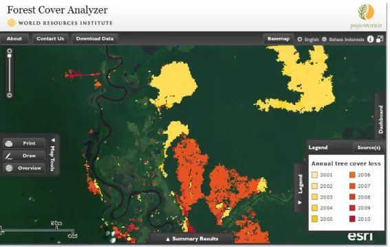
conducted, it is appropriate for indicative guidance maps to use broad large-scale data (eg satellite derived maps of forest cover or maps of protected area boundaries). Furthermore although the best available data should be used, these do not need to meet an absolute standard in terms of reliability, resolution and cut off dates. An example of what an indicative compliance map may look like is provided by Figure 1.
Figure 1: Example of an indicative map of forest area loss from the World Resources Institute's Forest Cover Analyzer
Source: http://www.wri.org/applications/maps/forest-cover-analyzer/ (accessed 15 January 2013)
Definitive compliance maps
The second approach includes analysis of detailed mapped information to provide
definitive compliance maps, (although areas of uncertain status or specified risk status might also be included). The primary purpose of such maps is to ensure compliance with defined sustainability standards such as those of the RED (see further discussion in Section 5) or other voluntary criteria. Such maps could be developed by producers (eg as part of the development of their sustainability schemes to meet RED requirement) or by competent authorities (with funding through, for example, biofuel permit application fees or biofuel production taxes). Because they aim to provide clear evidence of compliance definitive maps need to be of a much higher standard than indicative guidance maps, eg in terms of data reliability and resolution. Thus definitive maps should provide accurate field-scale information, so that suitable areas within otherwise apparently unsuitable areas such as protected areas can be identified. Such maps may also need to conform to certain specific cut-off dates (eg 2008 with respect to the RED).
Land use maps, and especially definitive compliance maps need to be developed with close adherence to the principles outlined in section 0 above, which therefore requires close consultation with stakeholders at national, regional and where necessary local levels, the use of data that are clearly fit for purpose, with new data collected if necessary to ensure this. Where they are produced by biofuel producers or others on their behalf (eg consultants as part of an SEA or EIA) they need to be verified by the national (or lower level) competent environmental authorities. Similarly if the maps are produced by governmental bodies responsible for agriculture or energy production, they would need the endorsement of the component environmental authority.
IEEP Land use mapping methodology| 25 The requirements for the development of definitive compliance maps are therefore
demanding and the process is likely to take a long time. Such maps may therefore be expected to be produced incrementally, eg covering certain easily mappable sustainability criteria first (eg protected areas) and/or by focusing in on certain areas where biofuel production may be most suitable (eg identified by SEA). In practice many areas will, however, remain classified as uncertain or other risk categories. Such areas will therefore require further investigation if biofuel producers wish to propose biofuel production within them, in which case the on-site assessments may be required, in addition to, or to support more detailed mapping.
On-site assessments
The third approach would be to use on-site assessments as the basis for a comprehensive simple project-level EIA approach to the accreditation of biofuel production. By itself such an approach would lack strategic assessments of needs and impact avoidance / reduction options, and would therefore be inefficient. However, it could be argued that it would provide a robust approach to ensuring sustainability where combined with indicative guidance mapping (ideally as part of an SEA). A drawback is that on-site assessments are costly. Assessments of some criteria, such as grassland biodiversity, would also need to be carried out by suitably qualified, independent accredited personnel, and in most countries such personnel would need to be trained and intuitions developed to enable this and oversee accreditation. However, the cost of such actions could be borne by producers (if they pay directly for the surveys) with a proportion of biofuel permit or taxation being used to support institutional requirements.
On-site assessments will in any case be necessary where adequate data are lacking for definitive compliance mapping, or where such maps have yet to be developed and approved. Furthermore, on-site assessments will be required in many countries to identify highly biodiverse grasslands as few countries have maps of these habitats that would be fit for the purpose of defining go and no-go areas for grasslands.
If organised as part of a strategic land use sustainability framework then the data collected from on-site assessments could be fed back into databases and mapping initiatives.
Box 3: Strengths and weaknesses of three broad approaches to ensuring compliance with biofuel and other land use sustainability criteria (continued on next page)
Indicative guidance maps
Strengths
• Provides a swift response to information needs because data can be
provided as soon as available, without additional analysis and consultations needed to identify and agree go/no-go areas.
• Allows more flexibility to make case-by-case decisions.
• Can provide information that feeds into SEA and similar processes that may enable strategic decision making by authorities (eg with respect to license allocations) and producers, such as identifying areas for further detailed investigation mapping and the production of detailed definitive maps (see below).
Weaknesses
• Requires a third party to interpret maps and make a decision on compliance with sustainability criteria.
• Additional decision making requires capacity (building) amongst actors (authorities) making ultimate decisions / assessments.
• Makes it more complex for developers to make decisions on land suitability
• Difficult for external parties (eg European Commission) to assess if sustainability standards have been met, and therefore not suitable by itself for compliance assessment
Definitive maps of ‘go’ and ‘no-go areas’
Strengths
• Provides clear guidance for operators, regulators and other stakeholders that can be used to demonstrate / monitor compliance with sustainability criteria.
• Provides the opportunity for national and international standardisation of equally stringent methodologies and interpretation of sustainability criteria, thereby facilitating comparisons between different countries;
• Can provide strategic control of land uses (eg as an output of an SEA) based on the aggregate consideration of demand for biofuel and other needs (energy, food, feed etc), by, for instance overlaying maps.
• Extension of the approach to other commodities could help extend sustainability criteria to the whole agricultural sector, and thereby help reduce indirect land use change;
IEEP Land use mapping methodology| 27 • Comprehensive mapping of go and no-go areas unlikely to be feasible and
appropriate as too simplistic.
• Certain dimensions cannot easily be taken into account (especially social issues), which makes justification for labelling of ‘go’ areas questionable or misleading.
• It is a slow process because it involves analytical and interpretative steps that should be agreed to by competent environmental authorities and other stakeholders.
• Requires data that are fit for purpose, up-to-date and reliable (especially for of go areas), which may constrain geographical coverage and coverage of all sustainability criteria especially biodiverse grasslands.
• Depending on the implementation, it constitutes an inflexible approach.
• Costs can be very large, creating a high burden if maps are created by environmental authorities or NGOs rather than the producers (eg through industry led roundtables);
• Some RED sustainability criteria, eg relating to highly biodiverse grasslands, are difficult to interpret in a standardised way and therefore defining go and no-go areas may be difficult or inappropriate;
• Provides a static map that cannot easily consider changing circumstances and the impacts of land use changes (eg relating to ecosystem
fragmentation) without frequent updates.
• Risks disenfranchising local stakeholders as top-down mapping processes often do not involve adequate stakeholder participation.
• May not be politically acceptable if based on criteria that are by parties perceived as outsiders, such as under the RED, and may be considered to be a barrier to trade, ensuing WTO disputes.
On-site assessments
Strengths
• Likely to be provide more reliable, detailed and fine-scale
assessment than those based on remote census data, IF carried out by appropriately qualified / trained personnel.
• Enables assessment of criteria that cannot be easily carried out using maps, such as highly biodiverse grasslands.
• Can contribute to the building up of comprehensive, detailed and ground-truthed databases to validate, update and fill gaps in map based approaches.
• Can be easily integrated with local stakeholder consultations etc.
• Creates local employment opportunities (assessors / certifiers).
• Self-assessments by producers reduce economic and administrative burdens on authorities.
• Wider strategic ecosystem / landscape-level issues are not
captured, rendering it difficult if not impossible to protect coherent / non-fragmented habitats, entire watersheds or landscapes.
• Expertise to carry assessments is not always available, and therefore training for surveys and certification is required (especially for certain criteria); which may increase costs.
• Comparatively costly, especially if there would a requirement for surveys of all or many areas.
• Prohibitive costs for small-holders (although collective assessments could help overcome this)
• It may be difficult to maintain consistent and appropriate
standards amongst countries / regions due to vary interpretations of sustainability criteria, thresholds and definitions and potential reliance on some form of subjective judgements
It is clear from this review that in practice the three approaches outlined above tend to overlap and interact, and each has potential roles to play in helping to plan and monitor compliance with land use sustainability criteria. Most obviously indicative maps can be compiled using the best available large scale-data to provide an initial indication of suitable areas that are then mapped in more detail according to strict data requirements, supported by site level assessments where necessary. This accords with previous proposals from IUCN for a framework that recognises that data requirements change as planning moves from a global to a local scale (Figure 2).
However, the IUCN proposals do not make a clear case for the screening at a global level, and in practice the initiatives reviewed in this study start at a national level, both for practical reasons (eg because national data may be better or more up to date) and to facilitate political ownership of the initiate from the onset. The need to use national data from the competent environmental authorities is particularly important issue with respect to the identification of protected areas due to differing international definitions (see Annex 1) and interpretations. Global datasets, such as the World Database of Protected Areas are in practice often out of date compared to national datasets.
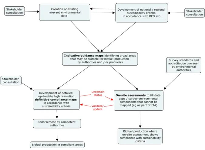
We propose that the three approaches should therefore all be used as part of a multi-level integrated sustainability compliance framework as outlined in Figure 3.
IEEP Land use mapping methodology| 29 Figure 2: IUCN's proposed common approach for land-use planning
Figure 3: A proposed land use planning and control framework for ensuring compliance with environmental sustainability criteria for biofuels
As shown in Figure 3, it seems appropriate to firstly work with stakeholders and environmental data holders to collate relevant environmental information as it becomes available. Such information can then immediately help steer biofuel production away from the most obviously environmentally sensitive and important areas. At the same time, international sustainability criteria such as those of the RED will need to be
interpreted in relation to national and regional circumstances. For example, decisions will need to be made on what constitutes highly biodiverse grasslands and how these can be identified. Such criteria should be developed in consultation with appropriate experts and other stakeholders and be approved by the appropriate competent
environmental authority. Analysis of the indicative guidance maps in relation to the criteria can then identify broad areas that appear to be suitable or unsuitable to varying degrees for biofuel production in relation to the sustainability criteria.
To further support environmentally sustainable land use planning it is then appropriate to develop definitive compliance maps that clearly and accurately indicate where biofuels definitely can and cannot be produced in accordance with the agreed environmental sustainability criteria. Because sustainability decisions may be based on such definitive maps, they need to meet certain quality standards to ensure that they are fit for purpose (as discussed further in section 0 below). Due to such demands definitive maps may in practice need to be produced incrementally, eg covering certain easily mappable and definable criteria first (eg protected areas if accurate boundary maps are available). Where significant
IEEP Land use mapping methodology| 31 new data collection or analysis is required then it may be appropriate to focus on selected regions that appear from the indicative mapping to be most suitable from biofuel production.
However, it is important to realise that definitive maps are unlikely to be able to provide a comprehensive categorisation, and therefore large areas will need to be mapped as being in some form of uncertain status, perhaps with some indication of possible environmental risk (eg taken from the broad inactive mapping). Indeed definitively mapped areas that show compliance with all sustainability criteria may be relatively scarce, and in some areas may only relate to areas that are already in intensive agricultural production. If producers then wish to consider biofuel production in areas with uncertain status then further assessments would be necessary, such as through an on-site assessment. On-site assessments will also be necessary in many cases to verify / refine the mapped data (eg to ensure land use
changes have not occurred and to refine boundaries) and resolve uncertainty over
environmental sustainability criteria that cannot be easily mapped, such as the biodiversity value of grasslands. Where on-site assessments are carried out then the collated data may then be used to validate and update the definitive compliance maps, as shown by the circular arrows in Figure 3.
As discussed above, an important principle is that the burden of proof for ensuring compliance with environmental sustainability criteria should be on the biofuel producer. Therefore in the framework outlined in Figure 3 it is appropriate for producers (or others acting on their behalf) to develop the maps, or for a governmental authority / agency to do this, such as those involved in agriculture, land use planning or the environment. However, all stakeholders should be involved in the process from an early stage, with local
stakeholders increasingly involved as fine-scale definitive mapping is undertaken. Also to ensure that environmental standards are complied with then the competent environmental authority (or an independent body appointed by the authority) should be responsible for firstly interpreting relevant international sustainability criteria (eg RED criteria) and then setting national sustainability standards that are consistent with them (eg on the definition of highly biodiverse grasslands). Secondly, they should have the ultimate responsibility for approving definitive compliance maps and ensuring appropriate standards are met in on-site assessments (eg by an accreditation process for surveyors).
Finally, another key principle that should be strictly adhered to is that the process outlined in Figure 3should be implemented in a fully transparent manner, with all stages and outcomes open to public scrutiny.