Department for Communities and Local Government
Metadata Guidelines for Geospatial Datasets in the UK
Part 2
Creating Metadata using UK GEMINI
Version 1.0, June 2006
document which was commissioned by the Department for Communities and Local
Government.
© Crown copyright 2006
This publication may be reproduced free of charge in any format or medium provided
that it is reproduced accurately and not used in any misleading context or in a
derogatory manner. The material must be acknowledged as Crown copyright and the
publication cited when being reproduced as part of another publication or service.
Metadata Guidelines for Geospatial Datasets - Part 2
Contents
Preface...4
1. INTRODUCTION ...5
2. GEMINI GUIDELINES ...6
2.1 Metadata elements ...6
2.2 Additional metadata elements...7
2.3 Extension of code lists ...7
3. ERRORS ...8
3.1 Impact of metadata errors ...8
3.2 Effect on searches ...8
3.3 Prevention and correction of errors...8
3.4 Common errors ...9
Annex A. Guidance for individual metadata elements ...14
A.1 Title ...14
A.2 Alternative title ...15
A.3 Dataset language ...16
A.4 Abstract ...17
A.5 Topic category...18
A.6 Subject...20
A.7 Date ...21
A.8 Dataset reference date ...22
A.9 Originator ...23
A.10 Lineage...24
A.11 West bounding coordinate ...25
A.12 East bounding coordinate...26
A.13 North bounding coordinate ...27
A.14 South bounding coordinate ...28
A.15 Extent ...29
A.16 Vertical extent information ...31
A.17 Spatial reference system...34
A.18 Spatial resolution...35
A.19 Spatial representation type ...36
A.20 Presentation type ...37
A.21 Data format ...38
A.22 Supply media...39
A.23 Distributor ...40
A.24 Frequency of update...45
A.25 Access constraint...46
A.26 Use constraints ...47
A.27 Additional information source ...48
A.28 Online resource ...49
A.29 Browse graphic ...50
A.30 Date of update of Metadata ...51
A.31 Metadata standard name...52
A.32 Metadata standard version ...53
Preface
This is the second part of a set of guidelines for metadata for geospatial datasets.
These Guidelines are intended for general use in the UK geographic information
environment, and particularly in support of the national geospatial metadata service,
gigateway. They are primarily concerned with geospatial data (i.e. that which
references data to a location on the surface of the Earth), and which has a limited
geographic extent (i.e. is restricted to a defined territory). They have been developed
within the context of a national geospatial metadata service (currently gigateway), and
the UK GEMINI metadata standard. However, they are sufficiently broadly based to
be applicable in a wider context of geospatial metadata creation and management.
The Guidelines are aimed at data managers and creators of metadata, providers of
metadata services and general data users. They include guidance on quality
management such that they could be used in the context of a national metadata
service.
This part of the guidelines provides a set of detailed guidelines for UK GEMINI
metadata elements. Part 1 covers the basics of metadata and provides an introduction
to the other two parts. It includes a glossary of terms and set of references. Part 3
deals with metadata quality and covers quality evaluation and quality management of
metadata including guidance on establishing acceptable quality levels.
Any comments on these guidelines or on the UK GEMINI metadata standard should
be sent to standards@agi.org.uk.
Metadata Guidelines for Geospatial Datasets - Part 2
1. INTRODUCTION
UK GEMINI
1, produced jointly by AGI and the e-Government Unit, defines a core set
of metadata elements for dataset discovery and other essential purposes. It provides
details of what metadata should be collected for geospatial datasets and is designed
for use in a metadata service such as gigateway
2.
This part of the Metadata Guidelines for Geospatial Datasets is aimed at those
creating metadata conforming to UK GEMINI. It provides detailed guidance for the
completion of each of the individual metadata elements in UK GEMINI. This expands
on existing guidance given in UK GEMINI and also other guidance notes produced to
support gigateway
3. It provides detailed guidance for the application of UK GEMINI,
but can be modified at a later stage to suit the proposed UK GEMINI2
4. It also
describes possible errors that might occur in such metadata and suggests actions to
guard against them. It also explains how to expand the metadata elements in addition
to those in UK GEMINI if required, and how to extend code lists of allowable values.
This Part should be read in conjunction with the other parts if these guidelines.
1UK GEMINI Standard Version 1.0 2004-10-12 Cabinet Office e-Government Unit (see www.gigateway.org.uk)
2
see www.gigateway.org.uk
3
for example see
www.gigateway.org.uk/metadata/downloads/Gigateway_metadata_guidelines_ukgemini.pdf
4
This will be based upon the European standard for core metadata for discovery, currently under development.
2. GEMINI GUIDELINES
2.1 Metadata elements
UK GEMINI comprises a set of 32 metadata elements. These elements are as follows:
Element number
Element name
1 Title
2 Alternative
title
3 Dataset
language
4 Abstract
5 Topic
category
6 Subject
7 Date
8 Dataset
reference
date
9 Originator
10 Lineage
11
West bounding coordinate
12
East bounding coordinate
13
North bounding coordinate
14
South bounding coordinate
15 Extent
16
Vertical extent information
17
Spatial reference system
18 Spatial
resolution
19
Spatial representation type
20 Presentation
type
21 Data
format
22 Supply
media
23 Distributor
24
Frequency of update
25 Access
constraint
26 Use
constraints
27
Additional information source
28 Online
resource
29 Browse
graphic
30
Date of update of metadata
31
Metadata standard name
32
Metadata standard version
Annex A provides detailed guidance on how to create each of these elements. Each
element is the subject of a separate table. The tables contain the following:
•
Metadata element name – name of the UK GEMINI element;
•
Definition – the formal definition of the element, as given in UK GEMINI;
•
Purpose and meaning – an explanation of what the element is and why it is
required;
•
Obligation – whether the element is mandatory or optional;
•
Occurrence – whether the element is single-valued or can have multiple
values;
Metadata Guidelines for Geospatial Datasets - Part 2
•
Data type – the form of the entry, whether it is a character string, real number,
integer, code or other class
5;
•
Domain – the allowable set of values;
•
Rules for how to fill in the entry – advice on how to complete the value;
•
Examples – a range of example entries;
•
Additional information – any other information of relevance
•
Other comments – that relate to the element.
2.2 Additional metadata elements
In many organisations, there is a need to record additional items of metadata to meet
specific local requirements. This may be to incorporate particular characteristics of
the data resources, or for particular applications. Additional metadata elements may
be included in a metadata implementation. These elements should be taken from ISO
19115
6, which includes a comprehensive collection of metadata elements for
geographic information.
2.3 Extension of code lists
Several of the metadata elements specified in UK GEMINI use enumerated code lists.
These are pre-defined sets of values identified by codes. They are useful to
standardise the entries to aid searches of metadata for specified values. The code lists
included in UK GEMINI are taken from ISO 19115. In some cases, the explanations
of the values have been modified to make them more appropriate to the UK context.
Some of these code lists will require extension. Additional codes may be created as
follows:
1. identify the new value, which should be distinct from existing values;
2. chose a name that encapsulates the essential concept;
3. provide a definition that is understandable and concise;
4. chose a new code that has not been used before for this element;
5. document the new codes, and disseminate them to users.
Such code extensions may be either specific to a metadata implementation in an
organisation or sector, or for general usage. In the latter case, proposed new codes
should be submitted
7for inclusion in the next version of UK GEMINI. It is expected
that future editions of UK GEMINI will incorporate such modified code lists.
5
Where the data type is another class, it is implemented as an additional set of elements. Examples are Distributor and Vertical extent.
6
ISO 19115: 2003 Geographic information – Metadata
7
Proposed new codes should be sent to standards@agi.org.uk
3. ERRORS
3.1 Impact of metadata errors
Errors having the greatest impact are likely to be those that affect searches based on:
•
where - geographical extent expressed in latitude and longitude or some
named standard area (administrative area, postcode, country);
•
what - theme, subject or topic;
•
when - date when data resource was current
Errors in the metadata elements used by these searches will result in over- or
under-selection of data resources and will degrade the quality of the service that is providing
the search facility. Inconsistencies in the capture or updating of metadata, such as the
categorisation of data subject(s) or topic(s), will further erode the quality of the
service.
3.2 Effect on searches
Having discovered a number of candidate data resources, the service user then
assesses the likelihood that any of these meet their requirements. They will need the
information in the other metadata elements such as abstract, lineage, data format, and
constraints to make their assessment. Inaccuracies, inconsistencies, or incompleteness
will detract from the quality of the service.
Information also needs to be topical or up-to-date. Services are bedevilled by
metadata containing information current at the inception of the service but never
maintained since. The service user needs to have reliable information about where
they can find out more about the data resource and how they can obtain that resource.
It is not uncommon for this to be out-of-date or have incorrect URLs or contact
telephone number.
3.3 Prevention and correction of errors
Prevention and correction of these errors is usually a combination of:
•
understanding the nature of the errors;
•
clear guidance on avoidance of errors at time of entry – metadata capture tools
may help here in validating entries;
•
staff trained in metadata capture who understand the nature of the data
resources being documented;
•
independent quality control with specified quality evaluation procedures,
acceptable quality levels and procedures for dealing with metadatasets that
fail;
•
periodic reviews of existing metadata to check that all information is current;
•
procedures for dealing with errors reported by service providers or service
users;
•
overall quality assurance process which reviews procedures in the light of
experience and aims to improve overall metadata quality.
Metadata Guidelines for Geospatial Datasets - Part 2
Further guidance on how to prevent and correct errors is given in Part 3 of these
Guidelines.
3.4 Common errors
Some common errors that lead to inconsistent results when searching across
metadatasets are:
•
Documentation is too general;
•
Extent is over-generalised;
•
Subjects and topic and categories are under-reported;
•
Incorrect or inconsistent date entries;
•
Different names are used for the same item in different places;
•
Missing values;
•
Information is not current.
The nature and impact of these types of error are described in more detail in Table 1,
together with suggested ways in which these errors can be prevented or corrected.
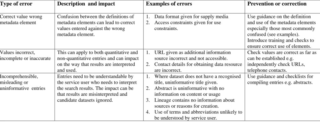
Other errors that may lead to misinterpretation of results are:
•
Correct value, but for the wrong metadata element;
•
Values incorrect, incomplete or inaccurate;
•
Incomprehensible, misleading or uninformative entries.
The nature and impact of these types of error are described in more detail in Table 2,
together with suggested ways in which these errors can be prevented or corrected.
Table 1. Some common errors leading to inconsistent results when searching across metadatasets
Type of error Description and impact Examples of errors Prevention or correction
Documentation too general
There are no absolute rules about how data resources should be “chunked” and individually documented. A metadataset can therefore refer to a dataset covering a single topic relating to a small area or major dataset series covering all or parts of UK containing many topics. This can lead to inconsistent search results with either over- or under-selection of datasets
1. Topographic mapping covering whole of GB at different scales to different specifications documented using one metadataset.
2. Reports produced by an
organisation relating to a variety of locations and dates documented using one metadataset.
Have clear guidance on the “chunking” of data resources for individual
documentation8 based on:
(i) how the data is used (stand-alone or as part of wider set);
(ii) continuity and extent of coverage; (iii) date of capture or maintenance; (iii) topics or subjects covered, and (iv) uniformity of specification within data resource.
Introduce checks to ensure consistency of approach across all metadata. Extent over-generalised This particularly applies when extent is
described in terms of standard geographical areas such as postcode districts, counties, or countries.
Inconsistencies in relating data resource coverage to these areas and the use of different extent names to refer to the same coverage results in either over- or under-selection of datasets.
1. Coverage given as UK or GB when restricted to England.
2. Coverage of UK referred to as GB. 3. Coverage given as England when
restricted to Hampshire only.
Have clear rules and user guidance on the relating of named extents to the coverage of data resources and
guidelines on the types of extents to be used. Where named extents form part of a nesting hierarchy (e.g. administrative areas) then any guidance should cover if and when all areas in the hierarchy should be included.9
Introduce checks to ensure consistency of approach across all metadata.
8
see 4.4 and Table 1 of Part 1 of these Guidelines
9
Metadata guidelines for geospatial data - Part 2
Type of error Description and impact Examples of errors Prevention or correction
Subjects and topic and categories under-reported
This particularly applies where there are enumerated lists of topics.
Inconsistency in the inclusion of
individual topics in metadata can lead to over- or under-selection of datasets.
Metadata for topographic map series does not include boundaries, elevation, inland waters, structure, and
transportation as topics (examples taken from UK GEMINI).
Use guidance on the recording of subjects or themes to promote consistency.10
Use closed lists wherever possible and discourage the use of free text.
Introduce checks to ensure consistency of approach across all metadata. Incorrect or inconsistent
date entries
There is often confusion between (i) the date when the data resource was
captured or last updated and (ii) the date when the data resource was released, published or made available. There can be further inconsistencies between the frequency of update and the recorded currency of the data resource. The impact of this is to give false returns for searches based on dates.
1. Date of capture of data resource later than date of publication. 2. Update reported as continuous but
date of last update reported as 10 years ago.
Use guidance on the recording of different dates to promote consistency. Introduce checks, preferably by
software, to ensure that the ordering of dates is consistent.11
Same item different name
This is particularly relevant where there is no closed list but a name or descriptor recurs which is common to many metadatasets. This may lead to
inconsistent results or, more frequently misinterpretation of results.
National Grid, British National Grid, National Grid of Great Britain.
Include frequently used standard names in any internal guidance.
Introduce checks to ensure consistency of approach across all metadata.
Missing values Where values relating to date, time or topic are omitted then these will have greatest impact on searches since these are the usual criteria used.
1. Omission of geographical extent. 2. Omission of dataset reference date. 3. Missing distributor or publisher. 4. Missing contact details.
Introduce checks, preferably software checks, to ensure that mandatory fields contain values.
10
see A.5 and A.6 for further guidance on UK GEMINI
11
see A.7, A.8, A.24 and A.30 for further guidance on UK GEMINI
Type of error Description and impact Examples of errors Prevention or correction
Information not current This can impact both on searches and the interpretation of search results since the metadata does not reflect the current information or only does so partially.
1. Content of data resource extended but no change to topics.
2. Abstract not updated to reflect change of specification.
3. Dataset updated but later date not entered in the metadata.
4. Use constraints added but not entered in metadata.
Introduce a regime of regular checks on all metadata to ensure that currency is assessed and updates made where needed.
Metadata guidelines for geospatial data - Part 2
Table 2. Other errors leading to misinterpretation of results
Type of error
Description and impact
Examples of errors
Prevention or correction
Correct value wrong metadata element
Confusion between the definitions of metadata elements can lead to correct values entered against the wrong metadata element.
1. Data format given for supply media 2. Access constraints given for use
constraints.
Use guidance on the definition and use of the metadata elements especially those most commonly confused (see examples). Introduce training and checks to ensure correct use of elements. Values incorrect,
incomplete or inaccurate
This can apply to both quantitative and non-quantitative entries and can impact on the way that results are interpreted and used.
1. URL given as additional information source incorrect and not accessible. 2. Contact details for obtaining data resource
are incorrect.
Check values are correct as far as can be established e.g.
independently check URLs, telephone contacts.
Incomprehensible, misleading or
uninformative entries
Entries need to be understandable by the service user who needs to interpret the search results. The impact can be that results are misinterpreted and candidate datasets ignored.
1. Where dataset does not have a recognised title, uninformative title given.
2. Abstract is uninformative with no information on content or usage 3. Lineage contains no information about
sources or reasons for creation.
4. Use of terms and abbreviations unlikely to be understood by service user.
Use guidance and checklists for compiling entries e.g. abstracts.
Annex A. Guidance for individual metadata elements
A.1 Title
Metadata element name Title
Definition name given to the data resource
Purpose and meaning The purpose of this element is to provide a readily recognisable and unique name for the data resource.
Obligation Mandatory Occurrence single
Data type Character String
Domain free text
Rules for how to fill in the entry
1. The title should be the formal or product name for the resource if existing.
2. If no name exists, then a title should be created that is short, encapsulates the subject, temporal and spatial coverage of the resource, and does not contain terms or jargon that makes it incomprehensible.
Examples OS MasterMap® topography
Voter participation in Liverpool local elections, 1994, by ward Additional information -
Metadata Guidelines for Geospatial Datasets – Part 2
A.2 Alternative title
Metadata element
name
Alternative title
Definition
short name, other name, acronym or alternative language title
Purpose and meaning
The purpose of this element is to record any alternative titles by
which the data resource is known.
Obligation OptionalOccurrence multiple
Data type
Character String
Domain free
text
Rules for how to fill in
the entry
1. There is no need to fill in this entry unless there are other
names used for the dataset, for example historic names.
2. Commonly used abbreviations or acronyms should be
recorded.
3. Other language equivalents should be recorded where they
exist, for example the Welsh language title (although this title
may refer to a different data resource).
4. Entries should be short and concise.
Examples
OS large-scale data
Additional information -
Other comments
-
A.3 Dataset language
Metadata element name Dataset language Definition language used in the dataset
Purpose and meaning This is the written language used for any text in the dataset. Obligation Mandatory
Occurrence multiple
Data type Character String
Domain free text
Rules for how to fill in the entry
It is recommended to select a value from a controlled vocabulary, for example that provided by ISO 639-212 which uses three-letter primary tags with optional subtags. The commonly used values for the UK are:
English ENG Welsh CYM Gaelic (Irish) GLE Gaelic (Scottish) GLA Cornish COR
In many cases, a default value of ENG can be applied. Examples CYM
Additional information -
Other comments 1. Note that according to ISO 639-2, codes should be in lower case. UK GEMINI needs to be modified accordingly.
2. UK GEMINI (and ISO 639-2) allows either CYM or WEL for Welsh. One of these should be used consistently. UK GEMINI needs to be modified accordingly.
12
Metadata Guidelines for Geospatial Datasets – Part 2
A.4 Abstract
Metadata element name Abstract
Definition brief narrative summary of the dataset
Purpose and meaning The abstract should provide a clear and concise statement that enables the reader to understand the content of the dataset.
Obligation Mandatory Occurrence single
Data type Character String
Domain free text
Rules for how to fill in the entry 1. State what the ‘things’ are that are recorded. 2. State the key aspects recorded about these things. 3. State what form the data takes.
4. State any other limiting information, such as time period of validity of the data.
5. Add purpose of data resource where relevant (e.g. for survey data).
6. Aim to be understood by non-experts.
7. Do not include general background information. 8. Avoid jargon and unexplained abbreviations.
Examples Sites of Special Scientific Interest in Wales, classified by habitat type, with the limit of each SSSI recorded as a polygon, as at 2001-06-30.
Additional information -
Other comments -
A.5 Topic category
Metadata element name Topic category
Definition main theme(s) of the data resource
Purpose and meaning The purpose of this element is to provide a basic classification for the data resource for use in initial searches
Obligation Mandatory Occurrence multiple
Data type enumerated class
Domain code list MD_TopicCategory Code taken ISO 19115 (see below) Rules for how to fill in
the entry
Select one or more categories that most closely represent the topic of the data resource. If in doubt, go by the topic categories rather than the examples. It is not necessary to include all categories which may be applicable, but only a limited number of most relevant should be chosen (e.g. topographic maps should not be classified as farming). Examples 013
Additional information -
Other comments For greater detail within a topic, use the element ‘Subject’
MD_Topic Category
Name Domain code
Definition
farming 001 rearing of animals and/or cultivation of plants
Examples: agriculture, plantations, herding, pests and diseases affecting crops and livestock
biota 002 flora and/or fauna in natural environment
Examples: wildlife, vegetation, biological sciences, ecology, sea-life, habitat
boundaries 003 legal land descriptions
Examples: political and administrative boundaries climatology/meteorology
/atmosphere
004 processes and phenomena of the atmosphere
Examples: weather, climate, atmospheric conditions economy 005 economic activities, conditions and employment
Examples: production, labour, revenue, commerce, industry elevation 006 height above or below sea level
Examples: altitude, bathymetry, digital elevation models, slope
environment 007 environmental resources, protection and conservation Examples: environmental pollution, waste storage and treatment, environmental impact assessment, monitoring environmental risk, nature reserves, landscape
Metadata Guidelines for Geospatial Datasets – Part 2
Name Domain
code
Definition
geoscientific information 008 information pertaining to earth sciences
Examples: geophysical features and processes, geology, minerals, soils
health 009 health, health services, human ecology, and safety
Examples: disease and illness, factors affecting health, health services
imagery/basemaps/earth cover
010 base maps
Examples: land cover, topographic maps, imagery, unclassified images
military intelligence 011 military bases, structures, activities
Examples: barracks, training grounds, military transportation inland waters 012 inland water features, drainage systems and their
characteristics
Examples: rivers, salt lakes, dams, floods, water quality, hydrographic charts
location 013 positional information and services
Examples: addresses, geodetic networks, control points, postal zones and services, place names
oceans 014 features and characteristics of salt water bodies (excluding inland waters)
Examples: tides, tidal waves, coastal information, reefs planning/cadastre 015 information used for appropriate actions for future use of the
land
Examples: land use maps, zoning maps, cadastral surveys, land ownership
society 016 characteristics of society and cultures
Examples: settlements, anthropology, archaeology, education, demographic data, recreational areas and activities, social impact assessments, crime and justice, census information
structure 017 man-made construction
Examples: buildings, museums, churches, factories, housing, monuments, shops
transportation 018 means and aids for conveying persons and/or goods
Examples: roads, airports/airstrips, shipping routes, tunnels, nautical charts, vehicle or vessel location, aeronautical charts, railways
utilities/communication 019 energy, water and waste systems and communications infrastructure and services
Examples: sources of energy, water purification and distribution, sewage collection and disposal, electricity and gas distribution, data communication, telecommunication, radio
A.6 Subject
Metadata element name Subject
Definition topic of the content of the dataset
Purpose and meaning The purpose of this element is to indicate the general subject area of the data resource using keywords. This enables searches to eliminate resources that are of no interest. Ideally, a standardised set of
keywords should be used, so that resources can be identified in any search. This element is similar to Topic, which has a coded list of high-level categories, whereas Subject allows more appropriate terms to describe the data resource.
Obligation Mandatory Occurrence multiple
Data type Character String
Domain free text
Rules for how to fill in the entry
1. Terms covering the subject of the data resource should be selected. 2. For a list of possible subjects, see the Integrated Public Sector Vocabulary (IPSV) from the e-Government Unit, at
www.esd.org.uk/standards/ipsv/. This should be used by government departments.
3. Other standard subject category areas may be used.
4. Other sectors may need to create their own lists of subject areas.
Examples Rural economy
Careers Centres
Environmental monitoring Local government structure Disabled toilets
Mobile phone base stations Unemployed people Flooding
Additional information -
Metadata Guidelines for Geospatial Datasets – Part 2
A.7 Date
Metadata element name Date
Definition date and time for the content of the dataset
Purpose and meaning This is the date or date range that identifies the currency of the data. It may refer to the period of collection, or the date at which it is deemed to be current.
Obligation Mandatory Occurrence single
Data type Date
Domain Date, or two dates defining the duration of the period, as defined by BS ISO 860113. Periods are recorded as (fromdate/todate). Either fromdate or todate (but not both) may be left blank to indicate uncertainty. The extended date format (YYYY-MM-DD) should be used, where YYYY is the year, MM is the month and DD is the day. Time (-HH:MM:SS, where HH is the hour, MM the minutes and SS the seconds) may be added if required.
Rules for how to fill in the entry
Dates may be to any degree of precision, from century (YY) to full date and time,
Examples 2001-01-01 1939/1945
/2003-03-31 2000/ 19
Additional information If the data resource relates to a historic period, then this is part of the subject, e.g. “cretaceous period”. In this case the date is the date of discovery or observation.
Other comments This element should not be confused with Dataset Reference Date
13
ISO 8601 Data elements and interchange formats – Information interchange – Representation of dates and times
A.8 Dataset reference date
Metadata element name Dataset reference date Definition reference date for the dataset
Purpose and meaning Dataset reference date is an identifying date for the data resource. It is a notional date of “publication” of the resource. It is different from Date which is the actual date of the currency of the data. For example, an atlas might have the reference date ‘2004’, but the data will have been collected over a period prior to this.
Obligation Mandatory Occurrence single
Data type Date
Domain The extended date format (YYYY-MM-DD) defined in BS ISO 8601 should be used, where YYYY is the year, MM is the month and DD is the day. It may be extended to include time (-HH:MM:SS), where HH is the hour, MM the minutes and SS the seconds.
Rules for how to fill in the entry
1. The date should be completed to a resolution sufficient to identify the version. Thus if the data resource is updated annually, only a year is required, whilst if it is updated weekly, a day is required. 2. If the resource is continuously updated or is a dataset series (e.g. a
map series), then a notional current data should be provided at a suitable level of resolution.
Examples 2001 2005-05
1997-10-01 Additional information -
Metadata Guidelines for Geospatial Datasets – Part 2
A.9 Originator
Metadata element name Originator
Definition person or organisation having primary responsibility for the intellectual content of the data
Purpose and meaning The purpose of this element is to identify the person(s) or
organisation(s) that are the major holders of the intellectual property for the dataset. The originator may not be the organisation that carried out the production of the resource (who might be a contractor), or the organisation that supplies the resource (the Distributor).
Obligation Optional Occurrence multiple
Data type Character String
Domain free text
Rules for how to fill in the entry
1. The name of the organisation should be held as succinctly as possible, to enable further enquiries to be made.
2. Additional information such as address details is not normally required if the organisation is well-known and can be located by a web search on its name.
3. There may be several entries where data comes from a range of sources. It may not always be possible to identify all of these. 4. Names of organisations should be given in full.
5. Individual names or positions should not be used for this. 6. If there is a commonly used abbreviation for the name, then this should be given in brackets, e.g. (OS).
Examples Ordnance Survey (OS)
Additional information This entry is indicative and does not carry any legal implications.
Other comments -
A.10 Lineage
Metadata element name Lineage
Definition information about the events or source data used in the construction of the dataset
Purpose and meaning The purpose of this element is to give an indication of how the dataset was created. It is useful in determining its fitness for purpose.
Obligation Optional Occurrence single
Data type Character String
Domain free text
Rules for how to fill in the entry
Include statements on the following:
• source material
• process used to create the data. including resolution of measurement
• method of updating
• any quality control processes
Examples Addresses are taken from the Postcode Address File (PAF) and the property found on the large-scale Ordnance Survey map. The
coordinates of an approximate centroid for the property are recorded to a resolution of 1metre. The dataset is updated from the PAF monthly updates. All results are checked by plotting a group of related addresses on the map and visually checking for errors.
Additional information Further details included in an external file may be referenced under ‘Additional information source’.
Other comments This element is similar to Abstract, and some information may be included in either element.
Metadata Guidelines for Geospatial Datasets – Part 2
A.11 West bounding coordinate
Metadata element name West bounding coordinate
Definition western-most limit of the dataset extent, expressed in longitude in decimal degrees (positive east)
Purpose and meaning The purpose of this element is, with the other bounding coordinates, to define a box. This needs to be in a common coordinate system, which is why latitude and longitude are used rather than a local grid. Spatial searches can then be carried out over all geospatial datasets.
Obligation Mandatory Occurrence single
Data type Real
Domain - 180.0 <= value <= 180.0 Rules for how to fill in
the entry
Only approximate values are required, sufficient to identify the extent on a global basis, e.g. to a tenth of a degree.
Examples -10.7
Additional information The West bounding coordinate usually has a value less than the value of the East bounding coordinate, except when the extent straddles the 180 degree meridian.
There are several services that can convert National Grid coordinates into latitude and longitude (e.g.
http://gps.ordnancesurvey.co.uk/convert.asp).
Other comments Strictly speaking, this element should be called “West bounding longitude”.
A.12 East bounding coordinate
Metadata element name East bounding coordinate
Definition eastern-most limit of the dataset extent, expressed in longitude in decimal degrees (positive east)
Purpose and meaning The purpose of this element is, with the other bounding coordinates, to define a box. This needs to be in a common coordinate system, which is why latitude and longitude are used rather than a local grid. Spatial searches can then be carried out over all geospatial datasets.
Obligation Mandatory Occurrence single
Data type Real
Domain - 180.0 <= value <= 180.0 Rules for how to fill in
the entry
Only approximate values are required, sufficient to identify the extent on a global basis, e.g. to a tenth of a degree.
Examples 2.8
Additional information The East bounding coordinate usually has a value greater than the value of the West bounding coordinate, except when the extent straddles the 180 degree meridian.
There are several services that can convert National Grid coordinates into latitude and longitude (e.g
http://gps.ordnancesurvey.co.uk/convert.asp).
Other comments Strictly speaking, this element should be called “East bounding longitude”
Metadata Guidelines for Geospatial Datasets – Part 2
A.13 North bounding coordinate
Metadata element name North bounding coordinate
Definition northern-most limit of the dataset extent, expressed in latitude in decimal degrees (positive north)
Purpose and meaning The purpose of this element is, with the other bounding coordinates, to define a box. This needs to be in a common coordinate system, which is why latitude and longitude are used rather than a local grid. Spatial searches can then be carried out over all geospatial datasets.
Obligation Mandatory Occurrence single
Data type Real
Domain - 90.0 <= value <= 90.0 Rules for how to fill in
the entry
Only approximate values are required, sufficient to identify the extent on a global basis, e.g. to a tenth of a degree.
Examples 61.6
Additional information The North bounding coordinate must have a value greater than the value of the South bounding coordinate.
There are several services that can convert National Grid coordinates into latitude and longitude (e.g.
http://gps.ordnancesurvey.co.uk/convert.asp).
Other comments Strictly speaking, this element should be called “North bounding longitude”
A.14 South bounding coordinate
Metadata element name South bounding coordinate
Definition southern-most limit of the dataset extent, expressed in longitude in decimal degrees (positive north)
Purpose and meaning The purpose of this element is, with the other bounding coordinates, to define a box. This needs to be in a common coordinate system, which is why latitude and longitude are used rather than a local grid. Spatial searches can then be carried out over all geospatial datasets.
Obligation Optional Occurrence single
Data type Real
Domain - 90.0 <= value <= 90.0 Rules for how to fill in
the entry
Only approximate values are required, sufficient to identify the extent on a global basis, e.g. to a tenth of a degree.
Examples 49.6
Additional information The South bounding coordinate must have a value less than the value of the North bounding coordinate.
There are several services that can convert National Grid coordinates into latitude and longitude (e.g.
http://gps.ordnancesurvey.co.uk/convert.asp).
Other comments Strictly speaking, this element should be called “South bounding latitude”
Metadata Guidelines for Geospatial Datasets – Part 2
A.15 Extent
Metadata element name Extent
Definition extent of dataset by country or subdivision of country
Purpose and meaning This element defines the geographical extent of coverage of the data resource relative to an administrative hierarchy. It enables searches to be carried out to find data relevant to the area of interest. Extent polygons can be implied through reference to an external gazetteer. Note that Extent is the coverage of the data resource, not the individual objects in the data resource. Thus if the data resource was national parks in England, the Extent would be ‘England’, even though many parts of England do not have National Parks.
Obligation Mandatory Occurrence multiple
Data type Enumerated class
Domain Code list as defined in ISO 316614. Rules for how to fill in
the entry
1. An area approximating to the extent of coverage of the data resource should be chosen. This should not be over-generalised (i.e. do not take it as Great Britain if it only covers England and Wales).
2. Where the extent is the whole of a country, the two-character country code should be given. (Note that UK (code GB) is a country in this context is not England, Wales, Scotland or Northern Ireland). 3. Where the extent is the whole of one or more of the primary sub-divisions of the UK, then the sub-division code or codes should be given, without a country code. Codes for higher level sub-divisions of the UK are as follows:
4. Where the extent is a combination of several of these areas, they should be given separately, e.g. “ENG, WLS” for England and Wales”, “ENG, WLS, SCT” for Great Britain. The composite codes EAW, GBN and UKM given in ISO 3166 should not be used.
Code Area CHA Channel Islands ENG England IOM Isle of Man
NIR Northern Ireland
SCT Scotland WLS Wales
14
ISO 3166 Codes for the representation of names of countries and their sub-divisions
subdivision codes should be given in full, preceded by the country code e.g. GB-BNH for Brighton and Hove.
6. Where the extent of the dataset does not coincide with any defined area or areas, then either the nearest equivalent including the area of coverage, or a set of multiple areas that make up the coverage should be provided. Thus for the South Downs National Park, the Extent would be described by GB-HAM, GB-WSX, GB-ESX
7. Where the extent is primarily an area of water, (e.g. for
hydrographic data), then an associated nearby land area should be used. (e.g. ENG for the southern part of the North Sea).
Examples ENG ENG, SCT
GB-ESX, GB-WSX IE, GB-NIR
Additional information ISO 3166 defines codes for countries (part 1) and their subdivisions (part 2). see www.iso.org/iso/en/prods-services/iso3166ma/index.html
for country codes list.
Metadata Guidelines for Geospatial Datasets – Part 2
A.16 Vertical extent information
Metadata element name Vertical extent information Definition vertical domain of the dataset
Purpose and meaning The purpose of this element is to describe the vertical range of the data resource (where relevant). Use only where vertical extent is
significant, e.g. in geology, mining, meteorology etc. Obligation Optional
Occurrence multiple
Data type Class
Domain This class comprises four elements: 1. minimum value
2. maximum value 3. unit of measure 4. vertical datum Rules for how to fill in
the entry
See separate entries for each element Examples -
Additional information This is rarely used.
Other comments Although UK GEMINI allows multiple values for this element, it is recommended that only a single value should be included.
Metadata element name minimum value
Definition lowest vertical extent contained in the dataset
Purpose and meaning The purpose of this element is to describe the lowest vertical extent of the data resource.
Obligation Mandatory Occurrence single
Data type Real
Domain Real number
Rules for how to fill in the entry
Identify approximate lowest altitude relative to the vertical datum (positive where above vertical datum).
Examples -100 Additional information -
Other comments -
Metadata element name maximum value
Definition highest vertical extent contained in the dataset
Purpose and meaning The purpose of this element is to describe the highest vertical extent of the data resource.
Obligation Mandatory Occurrence single
Data type Real
Domain Real number
Rules for how to fill in the entry
Identify approximate highest altitude relative to the vertical datum (positive where above vertical datum).
Examples 0 Additional information -
Metadata Guidelines for Geospatial Datasets – Part 2
Metadata element name Unit of Measure
Definition vertical units used for vertical extent
Purpose and meaning The purpose of this element is to describe the units used in the vertical extent measurements.
Obligation Mandatory Occurrence single
Data type Character String
Domain free text
Rules for how to fill in the entry
Describe units used for the vertical extent measurements. Examples metres
Additional information -
Other comments -
Metadata element name Vertical datum
Definition the origin from which the elevation values are measured
Purpose and meaning The purpose of this element is to establish the origin of the vertical extent measurements
Obligation mandatory Occurrence single
Data type Character String
Domain free text
Rules for how to fill in the entry
Identify vertical datum (zero level) for the vertical extent measurements
Examples Ordnance Survey datum (Newlyn) Additional information -
Other comments -
A.17 Spatial reference system
Metadata element name Spatial reference system
Definition Name or description of the system of spatial referencing, whether by coordinates or geographic identifiers, used in the dataset
Purpose and meaning The purpose of this element is to identify the way in which the data is spatially referenced in the resource. This may be a coordinates (e.g. in the National Grid of Great Britain) or geographic identifiers (e.g. in unit postcodes).
Obligation Mandatory Occurrence single
Data type enumerated list
Domain
Domain code Definition
001 National Grid of Great Britain 002 Irish Grid
003 Irish Transverse Mercator 004 WGS84 011 postcode 012 parish 013 ward 014 electoral constituency 015 census area
016 local authority (county/unitary/district/borough) 017 region
018 country
019 Health Authority area 020 travel-to-work area 021 other area type
Rules for how to fill in the entry
Identify the spatial reference system or systems used in the resource. Where there appears to be more than one spatial reference system used, take the one that is used in resolving any conflict between the spatial referencing systems (e.g. if the data is recorded referenced by unit postcodes, and a coordinate is then associated, then ‘unit postcode’ is the spatial reference system, whereas if the data is recorded by coordinate, and unit postcodes are added as an attribute, then it is ‘National Grid of Great Britain’).
Examples 001 Additional information -
Other comments The code list may need to be extended to cover additional spatial referencing systems (e.g. from the OGP Surveying and Positioning Committee formerly known as EPSG - see www.epsg.org, or for street name or property address).
Metadata Guidelines for Geospatial Datasets – Part 2
A.18 Spatial resolution
Metadata element name Spatial resolution
Definition measure of the granularity of the data (in metres)
Purpose and meaning The purpose of this element is to provide an indication of how detailed the spatial data is. It is equivalent to the ground sample distance. It should not be confused with the scale of a map which is purely a display attribute (the spatial resolution should be defined in the specification of the data resource).
Obligation Optional Occurrence single
Data type Real
Domain value > 0
Rules for how to fill in the entry
1. For data capture in the field, it is the precision at which the data is captured. This may be the accuracy for topographic surveys, or the granularity of sampling in an environmental survey.
2. For data taken from maps, it is the positional accuracy of the map (defined in the specification of the map series).
3. For image data, it is the resolution of the image. Examples 10.0
0.001 Additional information -
Other comments This should not be confused with precision which refers to the resolution of the measurements themselves. Thus for a buildings dataset, a building seed could be recorded to a precision of 0.1 metres, but since the requirement is for the seed only to be within the building footprint for the purpose of discriminating between buildings, the spatial resolution of the buildings dataset would be the typical size of the building, i.e. about 10 metres.
A.19 Spatial representation type
Metadata element name Spatial representation type
Definition method used to represent the spatial aspect of the data
Purpose and meaning The purpose of this element is to identify the way in which the real world is represented in the data resource (e.g. as lines or as entries in a table).
Obligation Optional Occurrence multiple
Data type enumerated list
Domain Name Domain
code
Definition
vector 001 vector data used to represent geographic data
grid 002 grid data used to represent geographic data
text/table 003 textual or tabular data used to represent geographic data tin 004 triangulated irregular network stereo model 005 three-dimensional view formed by the
intersecting homologous rays of an overlapping pair of images video 006 scene from a video recording
Rules for how to fill in the entry
Select the entry from the above table that corresponds to the data resource. If none apply (e.g. for a paper map) then do not use this element, but mention this in the Abstract.
Examples 001
Additional information The code list is taken from MD_SpatialRepresentationTypeCode in ISO 19115.
Other comments This is similar to Presentation Type. The code list may need to be extended in the future to cover additional spatial representation types.
Metadata Guidelines for Geospatial Datasets – Part 2
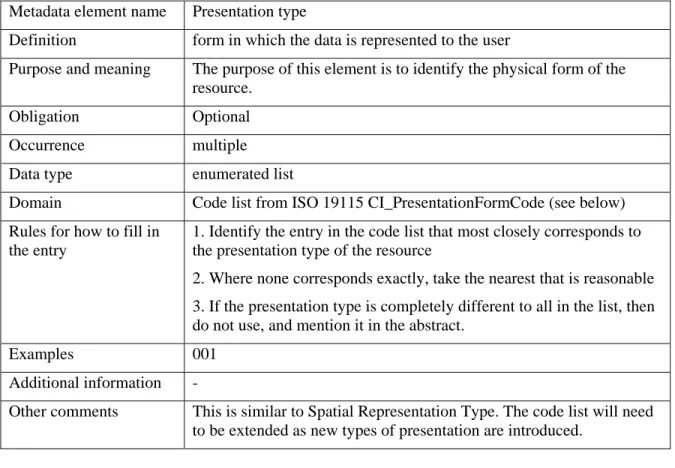
A.20 Presentation type
Metadata element name Presentation type
Definition form in which the data is represented to the user
Purpose and meaning The purpose of this element is to identify the physical form of the resource.
Obligation Optional Occurrence multiple
Data type enumerated list
Domain Code list from ISO 19115 CI_PresentationFormCode (see below) Rules for how to fill in
the entry
1. Identify the entry in the code list that most closely corresponds to the presentation type of the resource
2. Where none corresponds exactly, take the nearest that is reasonable 3. If the presentation type is completely different to all in the list, then do not use, and mention it in the abstract.
Examples 001 Additional information -
Other comments This is similar to Spatial Representation Type. The code list will need to be extended as new types of presentation are introduced.
CI_PresentationFormCode
Name Domain code
Definition
document digital 001 digital representation of a primarily textual item (can contain illustrations also)
document hardcopy 002 representation of a primarily textual item (can contain illustrations also) on paper, photographic material, or other media
image digital 003 likeness of something acquired through sensing and stored in digital format image hardcopy 004 likeness of something acquired through sensing and reproduced on paper,
photographic material, or other media for use directly by the human user map digital 005 map represented in raster or vector form
map hardcopy 006 map printed on paper, photographic material, or other media model digital 007 multi-dimensional digital representation of a feature, process, etc. model hardcopy 008 3-dimensional, physical model
profile digital 009 vertical cross-section in digital form profile hardcopy 010 vertical cross-section printed on paper, etc.
table digital 011 digital representation of facts or figures systematically displayed, especially in columns
table hardcopy 012 representation of facts or figures systematically displayed, especially in columns, printed on paper, photographic material, or other media video digital 013 digital video recording
video hardcopy 014 video recording on film
A.21 Data format
Metadata element name Data format
Definition format in which the digital data can be provided
Purpose and meaning The purpose of this element is to identify the various options for data formats that may be provided.
Obligation Mandatory Occurrence multiple Data type Character String
Domain free text
Rules for how to fill in the entry
1. Entries should be recognised formats for data transfer, either standard or proprietary.
2. If the data is not transferable (e.g. is view only), then do not use this element. Examples GML NTF DTF6.3 Additional information - Other comments -
Metadata Guidelines for Geospatial Datasets – Part 2
A.22 Supply media
Metadata element name Supply media
Definition type of media in which the data can be supplied
Purpose and meaning The purpose of this element is to identify the various types of media on which the resource can be supplied
Obligation Optional Occurrence multiple
Data type enumerated list
Domain
Name Domain code
cd Rom 001
dvd 002
dvd Rom 003
3.5 inch magnetic disk 004 5.25 inch magnetic disk 005 7 track magnetic tape 006 9 track magnetic tape 007 3480 cartridge tape drive 008 3490 cartridge tape drive 009 3580 cartridge tape drive 010 4 millimetre magnetic tape 011 8 millimetre magnetic tape 012 0.25 inch magnetic tape 013 half inch cartridge streaming tape drive 014
online 015 satellite 016 telephone Link 017
hardcopy 018
Rules for how to fill in the entry
1. Select the entries from the list that match the available supply media formats.
2. If the available supply media formats are not known, or if there is great flexibility in the formats available, then this entry should not be used.
Examples 015
Additional information The values in the code list are taken from MD_MediumNameCode in ISO 19115
Other comments These codes may need to be revised.
A.23 Distributor
Metadata element name Distributor
Definition details of the organisation(s) from whom the resource can be obtained Purpose and meaning This informs the user where to obtain the data resource
Obligation Mandatory Occurrence multiple
Data type Class
Domain This class comprises seven elements relating to the distributor: 1. contact name or title
2. name of the distributor 3. full postal address 4. telephone number 5. facsimile number 6. email address 7. web address Rules for how to fill in
the entry
1. See separate entries for each element. The first two elements are mandatory.
2. Other entries should only be given that are relevant and known. 3. Where there are several distributors, then a separate entry should be given for each.
Examples - Additional information -
Metadata Guidelines for Geospatial Datasets – Part 2
Metadata element name Distributor contact title
Definition role or position of the responsible person
Purpose and meaning This is the person to contact in the distributor organisation Obligation Mandatory
Occurrence single
Data type Character String
Domain free text
Rules for how to fill in the entry
1. A general job title should be identified for someone in a position of responsibility for the data resource.
2. Do not identify an individual by name, as this is subject to change without warning and the information is impossible to keep up-to-date.
3. Where no single individual is responsible, a generic role may be given.
Examples The mapping product manager Additional information -
Other comments -
Metadata element name Name of distributor
Definition name of organisation supplying the data resource Purpose and meaning This is the name of the organisation
Obligation Mandatory Occurrence single
Data type Character String
Domain free text
Rules for how to fill in the entry
The name of the organisation should be given in full, without abbreviations
Examples The Ordnance Survey of Great Britain Additional information -
Other comments -
Metadata element name Postal address of the distributor Definition postal address of the organisation
Purpose and meaning This enables the user to contact the distributor organisation by post Obligation Optional
Occurrence single
Data type Character String
Domain free text
Rules for how to fill in the entry
The full formal postal address (as defined for example by Royal Mail) should be given, including the postcode.
Examples Romsey Road, Maybush, Southampton. SO16 4GU. UK Additional information -
Other comments -
Metadata element name telephone number of the distributor
Definition telephone number by which individuals can talk to the organisation or individual
Purpose and meaning This enables the user to contact the distributor organisation by telephone
Obligation Optional Occurrence single
Data type Character String
Domain free text
Rules for how to fill in the entry
The full telephone number should be given.
Examples 08456 050505
Additional information - Other comments -
Metadata Guidelines for Geospatial Datasets – Part 2
Metadata element name Facsimile number of the distributor
Definition telephone number by which individuals can communicate with the organisation or individual by facsimile
Purpose and meaning This enables the user to contact the distributor organisation by fax Obligation Optional
Occurrence single
Data type Character String
Domain free text
Rules for how to fill in the entry
The full telephone number should be given.
Examples 0238079 2615
Additional information -
Other comments -
Metadata element name email address of the distributor
Definition internet email address which individuals can use to contact the organisation or individual
Purpose and meaning This enables the user to contact the distributor organisation by email Obligation Optional
Occurrence single
Data type Character String
Domain free text
Rules for how to fill in the entry
A valid email address should be given. Examples customerservices@ordnancesurvey.co.uk
Additional information -
Other comments -
Metadata element name web address of the distributor
Definition distributing organisation’s World Wide Web address
Purpose and meaning This enables the user to locate further information about the distributor Obligation Optional
Occurrence single
Data type Character String
Domain free text
Rules for how to fill in the entry
A valid World Wide Web address should be given.
Examples www.ordnancesurvey.co.uk
Metadata Guidelines for Geospatial Datasets – Part 2
A.24 Frequency of update
Metadata element name Frequency of update
Definition frequency with which modifications and deletions are made to the data after it is first produced
Purpose and meaning This identifies how often the updated data resource is made available to the user (for instance a dataset may be updated continuously, but released to the user only monthly).
Obligation Mandatory Occurrence single
Data type enumerated list
Domain
Name Domain code
continual 001 daily 002 weekly 003 fortnightly 004 monthly 005 quarterly 006 biannually 007 annually 008 as Needed 009 irregular 010 not Planned 011 unknown 012 Rules for how to fill in
the entry
1. Pick a value from the table that most closely corresponds to the update frequency for the data resource.
2. Where no value corresponds exactly to reality, the nearest should be chosen.
3. If there are two values that apply equally, then select the one indicating less frequency.
4. Where the data resource is not updated, use 011 (not Planned) Examples 005
Additional information The domain codes are taken from ISO 19115 (MD_MaintenanceFrequencyCode)
Other comments -
A.25 Access constraint
Metadata element name Access constraint
Definition restrictions and legal prerequisites for the access of the data
Purpose and meaning The purpose of this element is to identify any external restrictions on access to the data such as licence arrangements.
Obligation Optional Occurrence multiple
Data type enumerated list
Domain Sub-set of code list from ISO 19115 MD_RestrictionCode (see below). This list is a sub-set of MD_RestrictionCode given in ISO 19115, without those codes applicable to Use Constraints.
Rules for how to fill in the entry
1. The most common access restriction should be identified. 2. The appropriate code should be recorded.
3. More than one value may be included. Examples 001
Additional information Access constraints are different from Use constraints which are warnings about its suitability for particular types of usage. Other comments IN UK GEMINI, the name of the element should be “access
constraints” to match ISO 19115, there is a wrong spelling of “licence” and the code list.
Code list
Name Domain code
Definition
licence 005 formal permission required for use, usually requiring payment of a fee
restricted 007 withheld from general circulation or disclosure other restrictions 008 limitation not listed
Metadata Guidelines for Geospatial Datasets – Part 2
A.26 Use constraints
Metadata element name Use constraint
Definition restrictions and legal restraints on using the data
Purpose and meaning The purpose of this element is to describe any restrictions on usage of the data (as opposed to access)
Obligation Optional Occurrence multiple
Data type enumerated list
Domain Sub-set of code list from ISO 19115 MD_RestrictionCode (see below). This list is a sub-set of MD_RestrictionCode given in ISO 19115, without those codes applicable to Access Constraints. Rules for how to fill in
the entry
1. The most common use restriction should be identified. 2. The appropriate code should be recorded.
3. More than one value may be included.
4. If code 008 (other restrictions) is used, e.g. when the data resource is not to be used for navigation, then this additional information should be given in Lineage.
Examples 005
Additional information Use constraints are different from Access constraints which describe limitations on access to the data. A dataset can have open access (e.g. to look at it), but restricted use.
Other comments This will need to be modified to a free text field as the codes are not really suitable to convey the likely use constraints
Code list
Name Domain code
Definition
copyright 001 exclusive right to the publication, production, or sale of the rights to a data resource, or to the use of a commercial print or label
patent 002 exclusive right to make, sell, use or license data resource patent pending 003 produced or sold information awaiting a patent
intellectual property rights 006 rights to financial benefit from and control of distribution of non-tangible property that is a result of creativity
other restrictions 008 limitation not listed
A.27 Additional information source
Metadata element name Additional information source
Definition source of further information about the dataset
Purpose and meaning The purpose of this element is to record references to relevant information held externally, for example a reference (e.g. a URL) to background information.
Obligation Optional Occurrence single
Data type Character String
Domain free text
Rules for how to fill in the entry
1. Any references to external information that are considered useful may be recorded.
2. Do not use this to record additional information. Examples “For full details about this dataset, see http://
www.ordnancesurvey.co.uk/oswebsite/products/osmastermap/address” Additional information -