Morrow County
2005
Transportation System Plan
MORROW COUNTY
2005 TRANSPORTATION SYSTEM PLAN
Morrow
Prepared for:
County Planning Department P.O. Box 706
Irrigon, Oregon 97844
Updated by:
CTS Engineers
20085 NW Tanasbourne Drive, Suite Hillsboro, OR 97124
(503) 690-8080
and
The Mitchell Nelson Group 2116 NW Wilson Street
Portland, OR 97210
Original Morrow County 1997 TSP prepared by:
KCM, Inc.
7601 W Clearwater Avenue, Suite 303 Kennewick, WA 99336.1677
Morrow County
2005
Transportation System Plan
TABLE OF CONTENTS
Title Page No
.
1
.
Introduction...
1-1Transportation System Plan Organization
...
1-1Regulatory Setting
...
1-2 Physical Setting...
1-3 Public Involvement...
1-42
.
Goals and Policies...
2-1Introduction
...
2-1 Goals and Policies...
2-1Goal 1 Coordination/Process
...
2-1 Goal 2 Land Use...
2-2 Goal 3 Economic Development...
2-3 Goal 4 Quality of Life...
2-4 Goal 5 Roadway System..
...
...
Goal 6 Bicycle, Pedestrian, Equestrian, and Transit Modes
...
2-5 Goal 7 Air Transportation...
2-5 Goal 8 Freight and Goods Movement...
2-6 Goal 9 Finance...
2-63
.
Existing Conditions and Inventory...
3-1Introduction
...
3-1 Inventory Data...
3-1. . .
Issues Idenbfication
...
3-2 Open House and Community Stakeholder Survey Comments...
3-2 Existing Land Use and Population...
3-4 Existing Land Use...
3-4. .
Ex~stmg Population
...
3-4 Potential GrowthITraffic Impact...
3-5 Roadway Existing Needs...
3-6 Buildable Lands...
3-11 Transportation Facilities...
3-12 Roadway System...
3-12 Port of Morrow System...
3-30 US Forest Service Roads...
3-34 Pedestrian, Bicycle, Equestrian Facilities...
3-34 Transit and Para-Transit...
3-36. . .
. . .
Airport Facfi~bes...
3-38 Utilities...
3-39 Other Transportation ... 3-39 4.
Future Conditions...
4-1 Introduction...
4-1. .
Future Opportumkes...
.
.
...
4-1 Port of Morrow... .
.
...
4-1 ... Morrow County 4-2Future Land Use and Population
...
4-3...
Future Population 4-3
Future Travel Demand
...
4-4 Future Transportation Needs...
4-5...
Volume-to-Capacity Ratio Performance 4-5
. .
...
...
Future Connectmty.
.
4-8 Access Management...
4-16 State Highways...
4-18...
Other Transportation 4-195
.
Future Transportation System Options Analysis...
5-1...
Introduction 5-1
. .
Evaluation Criterla
...
5-1...
Transportation System Options Analysis 5-2
State Transportation Improvement Program Projects
...
5-2 Evaluation of Recommended Improvement Options ... 5-3 Summary of Recommendations...
5-13 6.
Transportation System Plan...
6-1...
Introduction 6-1
Modifications to Roadway Standards
...
6-1 Rural Gravel Roadways...
6-3 Rural Access Roadways...
6-3 Rural Collector Roadways...
6 4 Rural Arterial Roadways...
Access Management
...
6-4 Development Requirements...
6-7 Land Use Development Requirements...
6-7 Traffic Impact Assessment...
6-9 Access Requirements...
6-9 Right-of-way...
6-10 Modal Plans...
6-11Roadway System Plan
...
.
.
...
6-11 Pedestrian System Plan...
&14Bicycle System Plan
...
6-15 Transportation Demand Management Plan ... 6-15 Public Transportation Plan...
.
.
...
6-16 Rail Service Plan...
6-17 Truck Service Plan...
6-18 Airport Service Plan...
6-18...
Pipeline Service Plan
...
....
6-19Water Transportation Plan
...
6-19 Transportation System Plan Implementation Program...
6-20 Interjurisdictional Planning...
6-20 Recommended Changes to Code and Ordinances...
6-21 20-Year Capital Improvement Program...
6-217
.
Funding Options and Financial Plan...
7-1Introduction
...
7-1 Transportation Needs...
7-1 Historical Sources of Funding...
7-1...
Revenue Sources Currently Used in Morrow County 7-3
ODOT Funds
...
7-3...
...
Property Taxes
...
7-4Gasoline Taxes
...
7-4 Vehicle Registration Fees...
7-4 Special Public Works Funds...
7-5. . .
Project M~hgahon
...
7-5 Public Transportation Funds...
7-5...
Bicycle and Pedestrian Program Funds 7-5
Other Revenue Sources Not Currently Used in Morrow County
...
7-6...
Transportation System Development Charges 7-6
Local Improvement Districts
...
7-6...
Street Utility Fees 7-7
Financing Options
...
7-7. .
General Obligatmn Bonds
...
7-7...
Revenue Bonds 7-7
8
.
Regulations and Ordinance Modifications (Included in AppendixE)
Introduction
...
8-1 Recommended Modifications to the Morrow County Subdivision Code,Section 8.020 (Streets)
...
8-1 Recommended Modifications to the Morrow County Zoning Ordinance. Article 4 (Supplementary Provisions)...
8-29
.
Transportation Planning Rule Compliance...
9-1Introduction
...
9-1 Compliance Analysis...
9-1Appendices
...
A . Open House Comment Summaries A-1
B
.
Road Information Database...
B-1 C.
Roadway Standards...
C-1...
Introduction C-1...
Rural Arterial C-1 Rural Collector...
C-1 Rural Access...
C-1 Rural Gravel...
C-1 D.
Traffic Impact Analysis Guidelines...
D-1 Introduction...
D-1...
Determination of TIA Requirement D-1
Cost of a TIA
...
D-1...
Qualifications of Preparer D-1
...
Project Description and Study Area D-2
.
.. .
...
Ex~stmg Condihons D-2 . ....
Background Conditions D-3 . ....
Project Condihons D-4Trip Generation Table
...
D-5 E.
Modifications to the Zoning and Subdivision Ordinances...
E-1 F.
ODOT Interchange Influence Area Access Spacing Guidelines...
F-l Freeway Interchanges with Two-Lane Crossroads...
F-2 Freeway Interchanges with Multi-Lane Crossroads...
F-3 Non-Freeway Interchanges with Two-Lane Crossroads...
F-4 Non-Freeway Interchanges with Multi-Lane Crossroads...
F-5LIST OF TABLES
No
.
Title Page No.
2004 Population Estimates and Recent Census Data
...
3-5 State Highways Serving Morrow County...
3-13Surface Condition of Morrow County Paved and Gravel Roadways
...
3-15Programmed Improvements in Morrow County
...
3-16 Existing Bridge Deficiencies...
3-18 Historic Crash Rates by Roadway Segment...
3-21Crash Summary for All Non-State Roadways in Morrow County
...
3-23Volume-to-Capacity Standards for State Highways in Morrow County ... 3-24
Existing 30'" Highest Hour Volume-to-Capacity Ratios on State Highways
...
3-25 4-1 Future Population Data Summary...
4-3 4-2 Projected 2024 Volume-to-Capacity Ratios on State Highways...
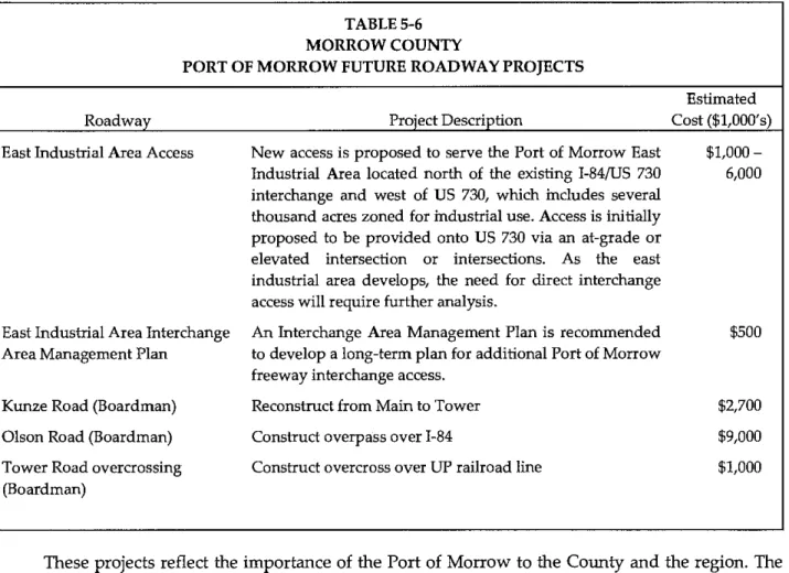
4-54-3 Recommended Access Management Standards for County Roads
...
4-174-4 Access Management Standards for the County's Non-Interstate Highways .. 4.19
5-1 State Transportation Improvement Program Projects in Morrow Co
...
5-25-2 Other Planned State Highway Improvements (OTIA III. Draft 2006-2009 STIP. Local TSPs)
...
5-3 5-3 Recommended Improvements on State Facilities...
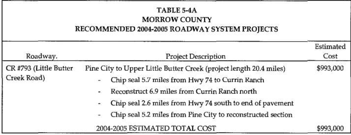
5-4 5-44 2004-2005 County Facilities Recommended Project Listing...
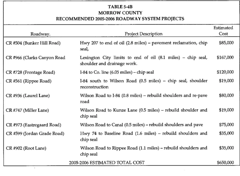
5-5 5-48 2005-2006 County Facilities Recommended Project Listing...
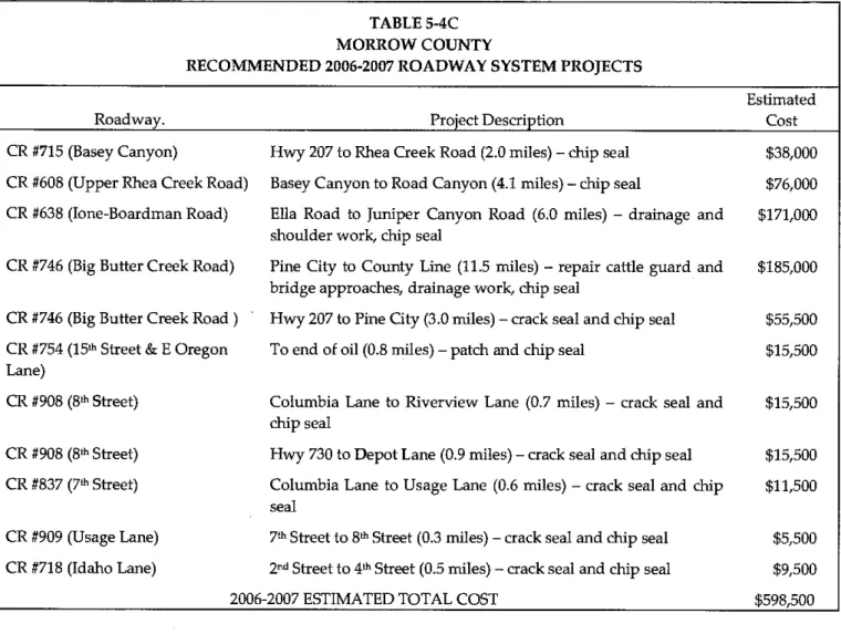
5-6 5-4C 2006-2007 County Facilities Recommended Project Listing...
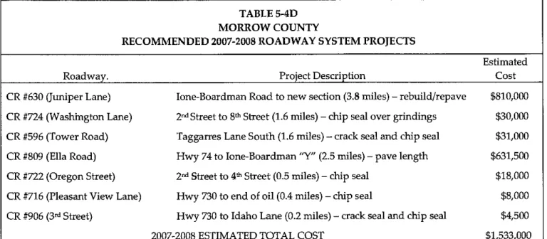
5-7 5-4D 2007-2008 County Facilities Recommended Project Listing ... 5-8...
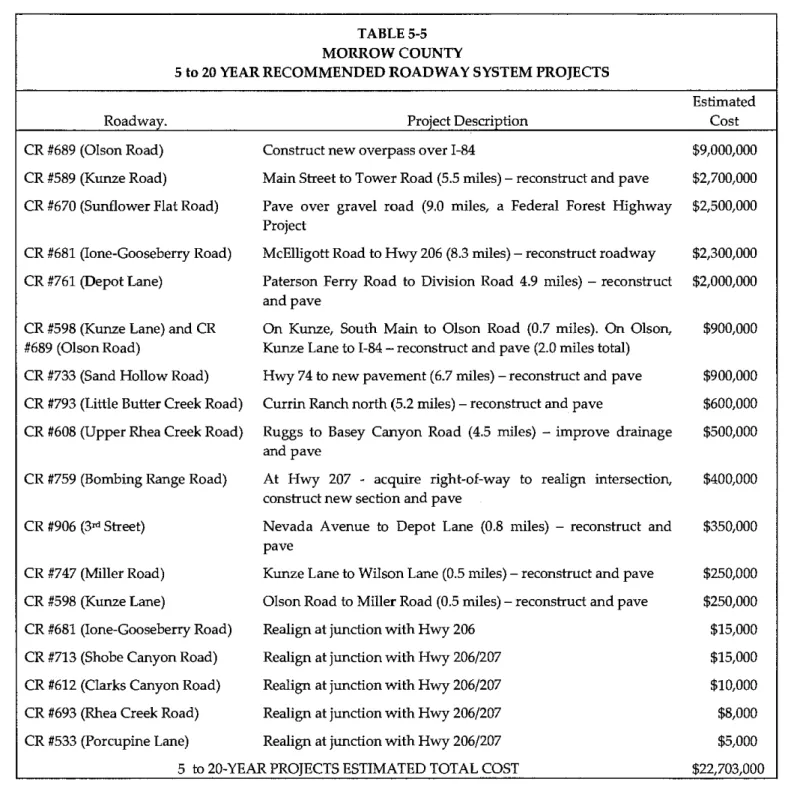
Morrow County 5- to 20-Year Recommended Roadway System Projects 5-9
Port of Morrow Future Roadway Projects
... .
.
...
5-10 Existing Bridge Deficiencies...
5-11 Transportation Improvement Options Recommendations...
5-13 Roadway Standards...
6-2 Guidance for Gravel Road Thickness...
6-3Recommended Access Management Standards for Morrow County Roads
...
6-5Access Management Standards for non-Interstate Highways in Morrow Co . 6-6
Permit Requirements for Land Use Development
...
6-8 Estimated Construction Costs per Mile for Rural Improvements...
6-12Recommended State Facility Improvements on in Morrow County
...
6-22Recommended Port/City Improvements in Morrow County
...
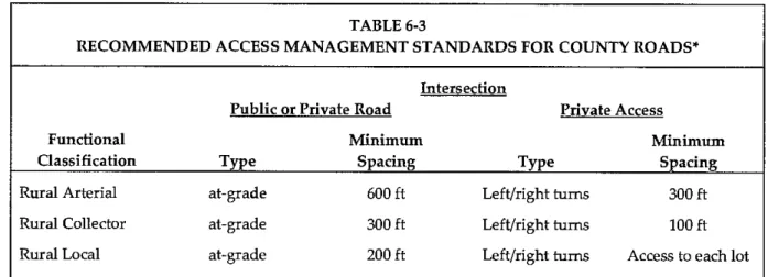
6-23Recommended 0-5 Year High Priority County Roadway Improvements
...
6-246-10 Recommended 5-20 Year Medium Priority County Roadway Improvements
...
6-266-11 Recommended Improvements for Non-Vehicular Modal Systems
...
6-277-1 Historic (1998-2002) Revenue Sources in Morrow County
...
7-2 9-1 TPR Compliance Analysis...
.
.
.
.
.
.
.
.
.
.
.
.
.
.
.
.
.
LIST OF FIGURES
No . Title Page No
.
Existing Functional Classification for County Roads
...
3-8...
State Highway Crash Data 3-22
Existing Traffic Volumes, Entire County
...
3-26 Existing Traffic Volumes, Boardman-Irrigon Area...
.
.
...
3-27 Existing and Future Traffic Volumes, Entire County...
4-6 Existing and Future Traffic Volumes, Boardman-Irrigon Area...
4-7 East Irrigon Area Rural Residential Development Local Street Plan...
4-11 West Irrigon Area Rural Residential Development Local Street Plan...
4-12 South In-igon Area Rural Residential Development Local Street Pl an...
4-13 East Boardman Area Rural Residential Development Local Street Pl an ... 4-14 West Boardman Area Rural Residential Development Local Street Plan...
4-15 6-1 Roadway Improvement Projects.. Preferred Alternative...
6-28 6-la Roadway Improvement Projects.. Preferred Alternative Boardman-In-igon...
6-29ACKNOWLEDGMENT
This project is partially funded by a grant from the Transportation and Growth Management (TGM) Program, a joint program of the Oregon Department of Transportation and the Oregon Department of Land Conservation and Development. This TGM grant is financed, in part, by federal Transportation Equity Act for the 21" Century (TEA-21), local government, and the State of Oregon funds. The contents of this document do not necessarily reflect views or policies of the State of Oregon.
CHAPTER
1
INTRODUCTION
The County of Morrow prepared its original Transportation System Plan (TSP) in 1997 as part of their overall Comprehensive Plan as required by Oregon Revised Statute
197.712 and the Transportation Planning Rule (TPR) OAR 660 Division 12 developed by
the Department of Land Conservation and Development (DLCD). The TPR and its provisions are designed to encourage the development of a planning process that allows development of future transportation facilities, protect the operation of existing and future transportation facilities, coordinate the review of land use decisions, and promote safe and convenient pedestrian and bicycle circulation. Oregon counties and cities over a certain size are required to develop TSPs and supporting implementation ordinances to carry out the TPR goals at the local level. Local jurisdictions are required to update their TSPs every 5-7 years. This TSP update (the 2005 TSF) is intended to guide transportation system development for the next 20 years. The plan will continue to be periodically updated to ensure it remains current and continues to meet the needs of the County.
This section of the TSP includes the following topics: Plan organization
Regulatory setting Physical setting
Public involvement summary
TRANSPORTATION SYSTEM PLAN ORGANIZATION
The County was assisted with the preparation of the plan by CTS Engineers, a transportation planning and engineering consulting firm, with assistance from the Mitchell Nelson Group, which led the land use planning and public involvement tasks. The original TSP was prepared by KCM, Incorporated. The organization of the TSP follows the process used to develop the study. Chapter 2 is an introduction of the plan's goals and policies. These transportation-related goals and policies, developed with input by the Technical Advisory Committee (TAC), provide a guide to the process and give direction to the development of future system improvements. The goals and policies not only ensure that the plan meets the intent of the TF'R but that it strives to meet the interests of the County.
Chapfey 3 is an assessment of existing conditions, which provides a better
understanding of the characteristics of the existing transportation system and identifies the issues that currently face the County. Included in this chapter is the discussion of transportation issues and opportunities, current land use and population, and existing transportation facilities.
In Chapter 4, the future conditions are discussed, including the projected areas of future population growth and transportation demand, as well as the future needs for greater connectivity. These future conditions represent the setting under which transportation alternatives can be compared.
In Chapter 5, alternatives are developed that reflect the County's goals and policies, and addresses the identified existing and future transportation issues and needs.
Two alternatives were considered. The first, the "unconstrained" alternative, identifies the complete range of transportation system improvements needed to serve needs of all of the County's transportation system users. The second alternative, a "constrained alternative, is a scaled-back alternative that addresses only portions of the anticipated future needs in consideration of potential resources expected to be available for the County's transportation network over the next 20 years. The constrained alternative generally follows the County's actual maintenance and improvement program of the past 10 years. The preferred alternative, based on input from the technical advisory committee, stakeholders and members of the public, is that which best meets the goals, objectives, and needs of the community.
In Chapter 6, the specific actions necessary to implement the plan's preferred alternative are presented. Recommended actions are also presented regarding future opportunities, land use requirements including development, right-of-way, and access management, and recommendations for transportation facilities and operations, including road standards and connectivity.
Chapter 7 is an evaluation of funding sources for transportation improvements. Funding options and a financial plan for meeting the recommended improvements identified in the TSP are presented.
In Chapters 8 and 9, the plan is discussed in relation to the Transportation Planning Rule in effect as of March, 2005. Chapter 8 focuses on ordinances that need to be adopted by the County to meet the rule, while Chapter 9 reflects how the TSP addresses each of the required elements of the TPR.
REGULATORY SETTING
The TSP is required by the State of Oregon Transportation Planning Rule, OAR 660 Division 12 developed by the DLCD and the Oregon Department of Transportation (ODOT). The TPR requires all jurisdictions to develop a transportation plan that includes the following elements:
Roadways Transit
Air, rail, water, and pipelines System alternatives
Financing
Policies and ordinances for implementation
In addition, the
TPR
requires local jurisdictions to adopt land use code amendments to protect transportation facilities, coordinate their plans with other jurisdictions, and encourage the development of bicycle and pedestrian facilities.PHYSICAL SETTING
Morrow County is located in northern Oregon approximately 150 miles east of Portland and 30 miles west of the City of Fendleton. The County is bordered by the Columbia River to the north, the Umatilla National Forest to the south, and Gilliam and Umatilla Counties to the east and west, respectively. Grant and Wheeler Counties share the southern border of Morrow County.
The topography within this 2,065-square-mile area varies from lowlands along the Columbia River to the Peak of Black Mountain, nearly 6,000 feet above sea level. Most of the county is largely rural in nature. There are five incorporated aties: Boardman, Heppner, Irrigon, Ione and Lexington. There are also six unincorporated rural centers: Cecil, Morgan, McNab, Ruggs, Hardman, and Lena. None of the County's rural centers are designated as rural communities under Oregon State law. Boardman is the largest city in the County, followed by Irrigon and Heppner. This TSP focuses on the
unincorporated areas of the County, up to the urban growth boundaries of the incorporated aties.
The northern part of the County, where Boardman and Irrigon are located, is moderately urban, especially along the 1-84 corridor just south of the Columbia River. The southern part of the County is very rural. Industry in the County is primarily natural-resource based, with agriculture, lumber, hydroelectric power generation and food processing as the principal industries.
Chapter 1 Inboduction ...p 4
PUBLIC INVOLVEMENT
Public involvement is a key element to an effective planning process. The TSP process was guided by members of the TAC. This committee was instrumental in the development of goals and policies, population projections, and roadway design standards, as well as the prioritization of roadway projects. Participating members of the TAC are listed below:
Barry Beyeler, City of Boardman Community Development Director Jerry Breazeale, City of Heppner City Manager
Roger Britt, Heppner resident
Cheryl Jarvis-Smith, TGM Grant Manager, ODOT Ron McKinnis, Port of Morrow
Carla McLane, Morrow County Planning Director
Bob Naims, Morrow County Assistant Public Works Director Burke O'Brien, Morrow County Public Works Director Terry Tallman, Morrow County Judge
Meetings of the TAC were facilitated by Joyce Jackson of MNG.
Other key elements of public involvement process included a project steering committee composed of key stakeholders, and a n open house conducted in September, 2004. Information provided by stakeholders and attendees at the open houses were instrumental in idenhfylng planning issues and needs for the county. An additional open house was held to present the draft TSP on February 8,2005.
The plan approval process, which takes place in 2005, will include meetings with the county planning commission and the county court, and will culminate in the adoption of the plan and associated modifications to the Zoning Ordinance and Subdivision Ordinance.
Chapter 2 Goals and Policies ...p. 1
CHAPTER
2
GOALS AND POLICIES
INTRODUCTION
Morrow County recognizes the importance of its transportation system to the long-term health and vitality of the County. Well-designed roadways contribute to the ability of an area to accommodate additional growth and development. Deficiencies in the system affect user safety and perception of community character and livability. As part of this Transportation System Plan (TSF), a series of goals and policies were designed to guide the development of the transportation system over the next 20 years.
The goals and policies included in this plan were developed by the Technical Advisory Committee (TAC), working under the requirements of the 1991 Oregon Transportation Planning Rule
(TPR).
The goals and policies developed for this process reflect both the required elements of the TPR and the interests of the County.Goals are general in nature. Each goal focuses on a particular aspect of the transportation system or the relationship between transportation and the viability of the County. The nine goals of this TSP are coordination/process, land use, economic development, quality of life, various transportation modes available in the County, and finance.
Due to the general nature of goals, they are difficult to implement and therefore make gauging plan success difficult. To assist in plan implementation, a series of policies have been developed for each goal. Policies are specific steps to be taken in plan implementation to ensure that the goals are met. Poliaes are directive in nature and often outline plan requirements.
The following section presents the goals and policies of the Morrow County TSP, which are consistent with the County's original TSP. These goals and policies will assist in prioritizing individual transportation projects to assure that limited transportation funding is expended efficiently so as to promote the development of a healthy transportation system.
GOALS AND POLICIES
Goal 1 Coordination/Process
Ensure that the Morrow County TSP is coordinated with other transportation providers, meets applicable regulations, and considers the needs of all transportation system users.
Policy 1.1. Coordinate the preparation of the TSF with transportation providers in Morrow County, including the cities of Boardman, Irrigon, Ione, Heppner, Lexington, and the Oregon Department of Transportation (ODOT).
Policy 1.2. Coordinate design standards with the cities within the County,
Chapter 2 Goals and Policies ....p 2
Policy 1.3. Coordinate transportation planning with the Port of Morrow.
Policy 1.4. Coordinate with ODOT for improvements on State facilities that could affect County facilities, through a ministerial or similar staff level review process to allow County Public Works the opportunity to review improvement plans prior to final design.
Policy 1.5. Coordinate transportation planning with adjacent counties,
Policy 1.6. Fulfill the transportation planning requirements of ODOT and the Department of Land Conservation and Development (DLCD).
Policy 1.7. Partidpate actively in the North East Area Commission on Transportation (NEACT) to promote inclusion of transportation improvement projects in Morrow County in the Statewide Transportation Improvement Program (STIP).
Policy 1.8. Use a 20-year time horizon for all transportation planning.
Policy 1.9. Review and update the capital improvement program annually and the plan elements periodically, in conjunction with the periodic update of the county Comprehensive Plan or every five years.
Policy 1.10. Evaluate the needs of all of the County's population groups,
including transportation disadvantaged groups such as older adults, young, physically challenged, and low-income county residents.
Policy 1.11. Evaluate the needs of commercial users, including manufacturing, timber, agricultural, and recreational users.
Policy 1.12. Include consideration of urban issues and rural issues in the TSP.
Policy 1.13. Provide extensive opportunities for public input throughout the transportation planning process.
Goal 2 Land Use
Support land use planning with appropriate transportation improvements.
Policy 2.1. Design all new roadways to meet county and state adopted road design standards, as a minimum.
Policy 2.2. Identify and reserve future road corridors.
Chapter 2 Goals and Pohcies ....p 3
Policy 2.3. Require new development proposals, plan amendments, and zone changes to conform to the TSP, as required by Section 660-12-045 (2) (g) of the TPR.
Policy 2.4. Require new development to provide appropriate access to the transportation system.
Policy 2.5. Require new development to identify transportation impacts and provide appropriate mitigation.
Policy 2.6. Require new development to dedicate right-of-way for transportation system improvements where appropriate. Establish procedures for the dedication of right-of-way necessary for the transportation system.
Policy 2.7. Utilize current state statute and rule for the acquisition of right-of- way necessary for the transportation system.
Policy 2.8. Utilize current state statute and rule for the abandonment of right-of- way no longer needed for the transportation system.
Policy 2.9. Utilize adopted ODOT access management standards for State facilities and proposed access management standards in this TSP for County facilities.
Policy 2.10. For the construction of roads, highways, and other transportation facilities and improvements not otherwise allowed outright in
resource lands (EFU and FU zones), request an exception to any statewide goal prior to construction.
Goal 3 Economic Development
Enhance economic development through transportation improvements.
Policy 3.1. Support transportation system improvements that contribute to economic development opportunities.
Policy 3.2. Pursue opportunities to improve access to business and employment centers for all modes of travel.
Policy 3.3. Pursue opportunities to improve access to tourist and recreation sites, such as the Columbia River Heritage Trail and the County OHV Park, for all modes of travel.
Chapter 2 Goals and Polmes ....p 4
Goal 4 Quality of Life
Promote a high quality of life in Morrow County by providing a well-developed transportation system that is appropriate to its surroundings.
Policy 4.1. Consider community character when providing transportation system
improvements in the urban growth areas.
Policy 4.2. Maintain the rural character of the County in the areas outside the
designated urban areas.
Policy 4.3. Preserve and maintain the scenic byway corridor along Willow Creek.
Goal 5 Roadway System
Provide and maintain a safe, efficient roadway system to provide mobility throughout the County.
Policy 5.1. Design and construct all new roadways to the County's adopted road
design standards, as a minimum.
Policy 5.2. Preserve the transportation system through regular maintenance.
Policy 5.3. Use the County's established procedure to set speed limits.
Policy 5.4. Provide roadway channelization (striping, turn lanes) where needed,
using American Association of State Highway Officials standards.
Policy 5.5. Use the Manual on Uniform Traffic Control Devices for traffic signal
and signing standards.
Policy 5.6. Establish criteria for the design of surface water detention for
transportation facilities.
Policy 5.7. Improve connectivity within the County by identifying and working
to improve additional road corridors.
Policy 5.8. Improve access for emergency vehicles to the transportation system.
Policy 5.9. Emphasize work zone safety for all workers.
Policy 5.10. Identify emergency routes for priority in snowplowing or other
circumstances where access is restricted.
Policy 5.11. Use the County Road Committee to identify and prioritize
modernization, preservation and construction projects.
Chapter 2 Goals and Policies ....p 5
Goal 6 Bicycle, Pedestrian, Equestrian, and Transit Modes
Support the use of other modes of transportation (bicycles, pedestrians, equestrians, and transit) through effective transportation improvements.
Policy 6.1. Include design features such as widened shoulder areas to
accommodate bicycles, pedestrians, and equestrians in the county roadway design standards.
Policy 6.2. Include design features such as pullout areas and turnarounds to accommodate school bus use in the county roadway design standards, in coordination with school bus providers.
Policy 6.3. Continue the development of the Columbia River Heritage Trail, and other similar facilities, for recreational uses.
Policy 6.4. Support the efforts of private transit systems within the County, such as older adult transporters.
Policy 6.5. Encourage the development of additional transit opportunities for transportation-disadvantaged groups within the County.
Policy 6.6. Coordinate with ODOT and the cities to construct bicycle and pedestrian improvements in unincorporated areas within the urban growth boundary.
Goal 7 Air Transportation
Support the local and regional air transportation needs of Morrow County.
Policy 7.1. Provide and maintain airport facilities to serve general aviation needs.
Policy 7.2. Expand airport facilities as necessary to support future service needs.
Policy 7.3. Coordinate with the Aeronautics Section of ODOT when preparing airport planning documents and reviewing proposed land use development in the vicinity of the airport.
Policy 7.4. Encourage the establishment of passenger and freight air service in the future.
Policy 7.5. Maintain minimum operating standards for the County's airports as required by the Federal Aviation Authority.
Policy 7.6. Establish appropriate land uses adjacent near airports that are compatible with airport noise levels and provide support to airport operations.
Chapter 2 Goals and Polictes ....p 6
Goal 8 Freight and Goods Movement
Promote efficient movement of freight and goods throughout the County.
Policy 8.1. Develop a freight and goods mobility strategy in conjunction with the Port of Morrow and others interested in freight and goods movement. Policy 8.2. Evaluate roads with weight restrictions and develop an improvement
strategy for those that adversely affect freight and goods mobility. Policy 8.3. Encourage improvements to rail freight facilities by encouraging
improvement to intermodal connections.
Policy 8.4. Establish rail crossing standards for county roads.
Policy 8.5. Support the development of passenger rail service if it is proposed in the future.
Goal 9 Finance
Use a fiscally sound approach to financing transportation system improvements. Policy 9.1. Develop a financial strategy for funding transportation system
improvements.
Policy 9.2. Explore introducing innovative funding methods, such as system development charges, to finance transportation system
improvements.
Policy 9.3. Coordinate with other transportation users and providers to seek joint funding opportunities for transportation system improvements. Policy 9.4. Actively seek available funding sources for transportation system
improvements.
Chapter 3 Existing Conditions and lnuentoy ...p. 1
CHAPTER
3
EXISTING CONDITIONS AND INVENTORY
INTRODUCTION
This chapter provides a n inventory of the existing transportation system, and other information relevant to the operation of the system.
The following topics are discussed in this chapter: Issues identification
o Transportation issues brought forth from the Technical Advisory Committee (TAC), staff, stakeholders and the public.
Existing land use and population
o Current population of the County.
o Overview of land uses within the County. Transportation facilities
o Description of existing roadways within the County, including discussion of road standards, travel demand, and roadway connectivity.
o Descriptions of existing pedestrian, bicycle, and equestrian facilities.
o Description of existing facilities for transit, air, rail, and other modes. Inventory Data
Data for this report were collected from several sources. Morrow County maintains a roadway database that includes information about each road's width, surface material, average daily traffic (ADT), and appurtenances such as culverts and approaches. Sigmficant data regarding state highways were obtained from the Oregon Department of Transportation (ODOT) and are included in the inventory. Discussions with county and state officials and observations from multiple driving tours were also major sources of data. Adopted TSPs from the cities of Boardman, Heppner, Ione, Irrigon, and Lexington provided useful information.
Data was also obtained from private transportation operators in the County, including the Port of Morrow and the Boardman Airport.
The final source of data was county residents, including the TAC, others identified as having a sigruhcant interest in transportation, and those who attended the two open houses held in late
2004 and early 2005.
Chapter 3 Existing Conditions and Inventory ....p 2
ISSUES IDENTIFICATION
A key role of public participation was to help identify the primary transportation issues that Morrow County faces today. Comments from two public meetings, an initial open house, responses to a community survey and input from advisory committee members and key stakeholders were used to identify key transportation issues facing the County. Issues raised at these sessions are listed below, ranging from general themes to specific suggestions. Detailed minutes and survey responses are included in the Appendix.
Open House and Community Stakeholder Survey Comments
Truck traffic in the County is increasing and will continue to grow with future industrial
development. An issue was raised concerning the adequacy of corner radii on the
existing streets through Boardman to the Port of Morrow industrial areas (Main Street, I-
84 Interchange #I64 accesses in Boardman). A suggestion was made to direct Port traffic
to 1-84 Interchange #I65 with better signage.
A new connection is needed to provide access to several thousand acres of Port of Morrow industrial lands located north of the I-84WS 730 interchange and west of US 730.
A number of existing roads were identified as needing functional classification changes, including McNab Lane, Sand Hollow Road, Baseline LaneIMyers Road, Paterson Ferry Road, Tower Road, Sunflower Road, Bombing Range Road, Dry Fork Road, Ridge Road. Additional measures to promote tourism and travel to the area were suggested, including providing blue information signs along the highway for attractions such as the Columbia River Heritage Trail (Heritage Trail), the Morrow County OHV Park, Oregon Trail, Willow Creek Lake, and other local parks and marinas.
Provide a dock on the Columbia River for recreational and tourist opportunities, such as the Stemwheeler.
Continued development of the Heritage Trail with additional local trail connections is also needed to promote tourism. Heritage Trail development should be combined with a joint Statelcounty program to provide additional emergency vehicle connections to the trail, and install directional signage along 1-84 and locally to guide visitors to the trail. A policy needs to be adopted for the strategic prioritization of resources by consolidating mobilization costs for roadway and utility improvements, rather than using a traditional "worst first" approach to prioritizing improvements and maintenance work. (The Public Works Department already employs this type of strategic prioritization in practice.)
The County Public Works Department uses a number of policies and standards that need to be adopted into the County's implementation ordinances. They address design requirements for "tee" intersections (promoting consolidation of split "tee" intersections into a standard three-legged configuration), pavedlgravel road intersections (promoting
Chapter 3 Existing Conditions and Inventoy ....p 3
pavement extension at least a few feet into the gravel road to minimize the amount of gravel tracked onto the pavement and reduce shoulder wear), cattle guards and gates, gravel road depth and cross-section, local improvement district consent agreements, drainage structures, connectivity requirements, and standards for low-volume roads. Railroad crossing enhancements (i.e., rubberized crossings) are needed to better accommodate pedestrians and bicyclists, particularly on Old Columbia Highway NE. Additional equestrian facilities for horse riders were suggested.
Olson Road overpass across 1-84 is needed to serve existing and future industrial development and employee access at the Port of Morrow, provide additional circulation in the Boardman area, and reduce the use of the Main Street overpass.
Safety and potential correction of the sharp curve on Highway 207 at Cutsforth Comer was identified.
Activity at the County's new off-highway vehicle park (OHV Park) should be monitored to identify needs for access improvements.
Major improvements to Rhea Creek Road are needed as a long-term project.
County ownership of Bombing Range Road should be pursued, as it is the only northlsouth connection in the County.
In addition to Bombing Range Road, the County roadway system needs an additional northlsouth connection between Boardman and Ione for general connectivity and emergency access needs. This second route has historically been referred to as Ione- Boardman Road. The existing impediments to transfer of Bombing Range Road to the County magnify the importance of Ione-Boardman Road as a second north/south connection. However, there are also impediments to constructing Ione-Boardman Road. The County has acquired a dedicated right-of-way that would allow construction of a road (Tower Road Extension) connecting the southern end of Tower Road to Highway 74 near Cecil. This indirect alignment, while beneficial for circulation and emergency access, would not fully meet the need for a second northlsouth connection.
The Oregon National Guard is planning on locating a major training facility at the Boardman Bombing Range. Planning to accommodate additional vehicle and heavy truck traffic generated by the training facility will need to continue beyond this TSP update, as it is yet to be determined how military vehicles will be transported (i.e., by barge, rail or highway). Military assistance should be pursued for road improvements necessary to serve the facility. Once the National Guard's plans for the area become more detailed, the County may pursue a Transportation Refinement Plan (TRP) or other appropriate means, to identify potential impacts of the military training facility and facilitate transportation improvements needed to serve the facility.
A high pressure gas line is planned to be extended from Ione to Heppner.
Guidelines are needed for conversion of paved roads to gravel, and gravel road standards need to be adopted in the TSP.
Chapter 3 Existing Conditions and Inventory ....p 4
A secondary east-west connection between Boardman and Irrigon is needed in the event
US 730 is blocked by a n event at the Umatilla Army Depot.
An all-season route is needed in southeast Morrow County to and from Umatilla County, i.e., Western Route.
The speedway project near Boardman should remain a long-term economic development strategy.
EXISTING LAND USE AND POPULATION
Land use and population play a key role in determining the demand on the transportation system. Land use has an impact on what kinds of roads are needed as well as where roads can be located. Changes in population and employment are used together with historical trends in traffic volumes to predict changes in vehicle trips that will use the future system.
Existing Land Use
The topography of the County plays a large part in the types of existing land use. The Columbia River borders the northern edge of the County. South of the river, lowlands gently rise to the Umatilla forest, which occupies the southern part of the County. The road system generally follows drainage corridors in the lower County, and is straight and rolling in the upper County.
The major population center, commercial operations, and transportation facilities are in the northern part of the County, close to the river. Port facilities, including docks and loading facilities, are situated near the riverfront. 1-84, the major east-west route across the County, also parallels the river, as does the Union Paafic rail line. The lowlands south of the river are well suited to agricultural use. This area is characterized by large tracts of land, including some used for farming as well as the bombing range and Army depot. Logging, recreation, and grazing are the major activities in the forested area.
Because land uses in the County are largely agricultural related, the population is sparse. Most
of the County's population is concentrated in the Irrigon-Boardman area, which also provides most of the land available for development in urban areas. Smaller population centers are Heppner (the county seat), Lexington, and Ione. Of these, Heppner has the most area available for future development. Heppner recently completed an industrial land study that evaluated the need to expand the City's Urban Growth Boundary (UGB).
Existing Population
Between the 1990 census and the 2000 census, the population of Morrow County increased by
about 44 percent, or 3,370 residents (Table 3-1). Countywide growth from 2000 to 2003 averaged
about 1.9 percent per year, compared to about 3.7 percent per year from 1990 to 2000. Almost all the recent growth has occurred in the northern part of the County; the southern part of the County has remained very stable. County population growth reflects the changes in
Chapter 3 Existing Conditions andinnentoy ....p 5
employment that have been experienced, which have also been concentrated in the northern part of the County and in adjacent areas of Umatilla County. These employment changes include an expanded cheese factory, and other tenants on properties in the Port of Morrow's Boardman Industrial Park.
I
TABLE 3-12004 POPULATION ESTIMATES AND RECENT CENSUS DATA
I
2000 Census 1990 Census 1990-2000
CityICounty Area 2004 PSU Estimate Count Count Growth
Boardman 3,120 2,855 1,387 106% Heppner 1,420 1,395 1,412 -1% Ione 340 321 255 26% Irrigon 1,790 1,702 737 130% Lexington 260 263 286 -8% Unincorporated 4,820 4,459 3,548 26% Area Total 11,750 10,995 7,625 44%
Potential GrowthITraffic Impact
Gvowth
The Office of Economic Analysis (OEA) publishes population data prepared by Portland State University (PSU) for all counties in Oregon. The latest OEA estimates, based on the 2000 census, show an estimated population of 11,750 for the County in 2003, increasing by 54 percent to 18,100 by 2025, an average annual increase of about 2.5 percent. OEA publishes population estimates by County out to the year 2040. In percentage terms, Morrow County ranks in the top three counties in the state for projected population growth over five of the eight 5-year periods from 2000 to 2040, and no lower than the top five over the entire 40-year period.
In evaluating existing land uses and population as well as its distribution, the issue of potential growth and resulting traffic impact should be considered. Two types of growth are anticipated. One is the growth in residential housing development. This will likely take the form of new subdivisions on currently vacant land within the UGB. These vacant parcels are distributed largely south and west of Irrigon and south and west of Boardman. Additional residential development outside the UGBs will be limited, because in 2000 the County enacted a two-acre minimum for residential development in rural residential zones.
The other opportunity for growth is through economic development led by expansion of Port of Morrow industrial facilities throughout the County. The Port, through its 30-year history, has
developed a significant inventory of developable land at its three industrial park sites: the Boardman Industrial Park, located east of Boardman and north of US 730; the Airport Industrial Park, located west of Tower Road; and the South Morrow Industrial Park, located at the Kinzua sawmill complex just outside the City of Heppner. The City of Heppner is currently evaluating the need for an expansion of its urban growth boundary to accommodate more industrial lands along the Highway 74 corridor.
Traflc Impact
The traffic impacts of these growth opportunities differ. The impact of residential development will require transportation planning and smart growth techniques to ensure adequate connectivity between new development and existing highway and road corridors. Creating block length and cross-circulation standards for new residential and commercial development
will be a n important element of the County's access management strategy.
Development of Port facilities will generate the need to upgrade transportation facilities including highway, rail, and barge facilities. In addition to the continued orderly movement of goods through the Port of Morrow, it will be important that the work force have adequate access to the Port's industrial facilities. A portion of this work force may use bike or pedestrian facilities to gain access, but major emphasis will continue to be focused on an interconnected system of roadways.
Another of the impacts to be expected by the growth within the Port of Morrow is the need for improved access to its east industrial site. This site is a portion of the Boardman Industrial Park. It is located north of 1-84 and west of US 730. A new access to this industrial area should be developed near the I-84/US 730 interchange, as discussed in the roadway element of the plan.
Depending on the needs of the Port of Morrow, an access from US 730 south of the Union Pacific main line may be appropriate. If this is developed, an additional access north of the Union Pacific main line should also be created. This access may be constructed west from Paterson Ferry Road, connecting to the old Columbia River Highway.
Roadway Existing Needs
Morrow County maintains jurisdiction for design, construction, and maintenance of county roadways within its boundaries. The County also maintains jurisdiction for non-state facilities located outside of city limits but inside the urban growth boundary area. Towns and cities located within the County are responsible for their facilities. ODOT is responsible for design and construction of state facilities.
Ordinances and design standards for county roadways are described in the County's subdivision ordinance and requirements. Design standards for bicycle and pedestrian facilities in the County are limited and are included in county roadway design standards developed in
Chapter 3 Existing Conditions and Inventory ....p 7
subsequent sections of this TSP. Existing functional classifications for County roads are shown in Figure 3-1.
Overlying the County's roadway jurisdiction and that of the City of Boardman are the Port of Morrow facilities. The Port is a participating agency along with Boardman and Morrow County in developing improvements needed to meet the requirements of industrial development. The Port of Morrow's facilities include the Boardman Industrial Park, the Airport Industrial Park, and the south Morrow Industrial Park. Standards necessary to meet the load rating requirements of port industrial users should be coordinated between Morrow County, the City of Boardman, the Port of Morrow, and ODOT.
While the 2005 Morrow County TSP was being prepared, the Oregon National Guard announced plans to create a major military training facility at the Boardman Bombing Range in north County. At the time this plan was prepared, the Oregon National Guard was evaluating several options for delivering heavy vehicles such as tanks to the bombing range, including rail, barge and truck. Any of these options could require improvements to the roadways serving the Bombing Range to meet necessary load requirements. Analysis of roadway improvements to serve movement of both tanks and personnel for a tank training facility on the Bombing Range has not yet begun, as plans for the training facility are in the very early stages. Planning for improvements needed to accommodate this facility will need to continue beyond this TSP, and may require future TSP amendments, preparation of a Transportation Refinement Plan (TRF) for the area, or other appropriate means.
County Roadways
Evaluation of need relating to the County's roadway network falls in the following categories: Maintenance of existing roadways
Safety Capacity
Economic development
Maintenance
By far the most overwhelming need of the Morrow County road system is for maintenance. The County currently has 340 miles of pavement or hard surface roads and 600 miles of gravel roadways. The County annually budgets approximately $2.8 million for the maintenance of this roadway network to maintain the existing level of service and, where possible, to provide an
improved level. In Chapter 5, road improvement projects for screening are presented in a series
of tables. Also listed in the proposed projects are modifications to the County's adopted road standards, including addition of gravel road standards. Including gravel road standards in the adopted TSP increases the potential funding sources for their construction and maintenance.
FUNCTIONAL CLASSIFICATION (MORROW COUNTY)
MINOR I)RTERIAL MAJOR COLLECTOR MINOR CCUECTOR COUNTY BOUNDMI
FEDERAL LANDS BOUNDeRI RAIL ROAD
STATE HIGHWAY ND.
INTERSTATE No.
TRANSMISSION AND PIPELINE UTILITY CORI(IOD2S U.N.F. WHEELER C O U N T Y G R A N T C O U N T Y N A T I O N A L F O R E S T
/
4
-
-TWWSPORTATlON STRUCTURAL LANDSURVEMNG FigureNo. 3-12- "." ,MA=- m MORROW COUNTY TSP
"ILSsrn* -m a,,,.
ODOT/ MORROW COUNTY
Englnsers R l ~ : , 3 o l l . - . m
r w m , :*&,.!2 UPDATE
Chapter 3 Exlsttng Condltlons and Inventory ...p 9
Safety
From available information about the safety record of county roadways, it is known that improvements should be scheduled to address existing needs. Safety improvements identified by County staff and other stakeholders are included in the recommendations in Chapter 6. Safety is also known to be an issue with respect to farm-to-market roadways in the County. During the harvest season, the intermixing of slow-moving truck traffic and other forms of transportation can be an issue.
US 730 in Morrow County and Umatilla County has been posted as a safety corridor, due to high rates of crashes involving truck traffic and turning movements. Designation as a safety corridor provides eligibility for additional law enforcement and data collection aid. In addition, to increase law enforcement, ODOT recently began a multi-year, $2.325 million corridor safety improvement project for US 730. The two-lane corridor not only serves as an important freight connection to Washington State, it also has many school bus stops, and bicycle and pedestrian
traffic use the shoulders. There are many driveways and turning movements, resulting in
frequent rearend collisions. The project is divided into multiple phases. Work will include access management improvements, construction of turn lanes, and ultimately construction of frontage roads to serve local traffic and non-motorized travel needs.
The Morrow County portion of the corridor will be the last segment completed, as it involves complex access negotiations with multiple property owners. Recommendations for the Morrow County segment of US 730 are unlikely to be funded prior to the 2008-2011 Statewide Transportation Improvement Program (STIP). Planning for the 2008-2011 STIP will begin in about two years. Potential improvements for US 730 resulting from the safety study include access management/consolidation, construction of frontage roads, intersection traffic control changes, geometric improvements, etc.
Two other safety issues were also identified. The first was the need for an alternative to US 730 for circulation between Irrigon and Boardman in the event of an emergency at the Umatilla Army Depot or the Port of Morrow. The second was the need for an additional north/south connection between Boardman and Ione in addition to Bombing Range Road. A second northlsouth route addresses overall County circulation and safety and emergency vehicle access
needs. It would provide both a n alternate route for emergency vehicles and a fire break in an
area of the County with extensive grasslands and predominately easterly winds. Finally, a north/south connection would ensure that the County would have one north/south roadway under its authority. The northern section of Bombing Range Road is presently controlled by the US Navy. With the possibility of a military training facility being constructed on the Boardman Bombing Range, as was revealed to the County while the 2005 TSP was being prepared, concerns were raised over the potential for Bombing Range Road to be closed. While the military has expressed no desire to close Bombing Range Road, it remains a possibility.
The second northlsouth route has historically been referred to as Ione-Boardman Road. The County has acquired a dedicated right-of-way that would allow construction of a road (Tower
Chapter 3 Existing Conditzons and Inventory ....p 10
Road Extension) connecting the southern end of Tower Road to Highway 74 near Cecil, which would be useful for the western mid-County area. However, this indirect alignment would not fully meet the need for a second northlsouth connection.
The existing impediments to transfer of Bombing Range Road to the County magnify the importance of Ione-Boardman Road as a second north/south connection. However, there are also impediments to constructing Ione-Boardman Road. Throughout the 1980's and 1990's the County participated in negotiations with the State of Oregon and major property owners, including the Boeing Agri-Industrial Company and Threemile Canyon Farms, to secure right- of-way for an Ione-Boardman Road by extending Ella Road north to Boardman. This effort was hampered by a 2001 Multi-Species Candidate Conservation Agreement with Assurances (MSCCAA) for the Washington ground squirrel, ferruginous hawk, loggerhead shrike, and sage sparrow, in the event any or all of the these species are listed in the future as endangered or threatened.
The 2001 MSCCAA was researched in the May 11,2005 Federal Register as part of the 2005 TSP. The Federal Register states in part (emphasis added):
"The majority of existing colonies (in Oregon and throughout the species' current range) [i.e., colonies of the Washington ground squirrel] are located on the Boardman Bombing Range and the Boeing tract, which contain the largest contiguous suitable Washington ground squirrel habitat. Although Boardman Bombing Range activities are not certain, they are not expected t o
change significantly in the foreseeablefuture."
The major military training facility now in the initial stages of planning by the Oregon National Guard would be certain to significantly change activities on the Boardman Bombing Range in the foreseeable future. This information is not addressed by the May 2005 Federal Register or the 2001 MSCCAA. The Oregon National Guard's plans for a military training facility on the Boardman Bombing Range create both an opportunity and an obligation to revisit the 2001 MSCCAA and revisit the ability to construct an Ione-Boardman connection. Action steps to assist the County in pursuing this issue further are included in the 2005 TSP implementation program.
An evaluation of the capacity of the Morrow County roadway system is included later in this chapter. Indications are that capacity-related issues on the County's roadway system are very low in number. The one exception to capacity issues are roadways developed within the Port of Morrow's industrial parks, which will be required to serve increasing industrial development. Economic Development
The most significant transportation system needs beyond maintenance are economic development requirements created in the Port of Morrow industrial parks. As continued
Chapter 3 Existing Conditions and Inwento ry....p 11
industrial development occurs in the Port, existing roadways require expansion to accommodate increased vehicle capacity, turning movements, and increased weight load requirements. A list of projects created by anticipated economic development requirements is generated in Chapter 4 and screened in Chapter 5.
Buildable Lands
Significant tracts of buildable lands exist in Morrow County both within and just beyond the UGBs of Boardman and Irrigon. The areas outside the UGBs are zoned RR1, a zoning designation intended to recognize the existence of smaller lots outside of UGBs and allow continuation of single family dwellings in areas where this development has been established. However, when the County increased the minimum lot area for residential development outside the UGB from one acre to two acres in 2000 to reflect official state policy discouraging development of smaller lots in rural areas, the potential development on these parcels was substantially reduced.
Other buildable lands are located south of Irrigon in the Division Streetl4th Road area and west of Irrigon/north of US 730. These lands are also designated RR1 with the revised minimum lot size of two acres.
Buildable lands exist south of Boardman city limits, between Tower Road and Bombing Range Road. A portion of these lands are zoned Farm Residential, allowing two-acre minimum lots to be developed. The balance is zoned Small Farm 40.
Each of these areas is representative of the need to develop minimum requirements for the creation of new county roads as this property develops. These new roadways should be provided at a spacing that meets Morrow County standards for block length. Requirements of this TSP suggest not more than 600 feet of roadway be developed in this area without interconnecting roadways. With two-acre minimum parcel size for residential development, density will be very low. Local road standards are expected to be adequate for new internal roadways in these buildable lands. Actual roadway locations will be refined through the site development process.
In addition, issues of access management are critical, especially along US 730, where standards
are established for minimum spacing and new connections. The US 730 safety corridor study will update access management standards and identify improvements for the Morrow County segment of the highway. Standards presented in Chapter 6 recommend minimum distance between connections for roads and highways elsewhere in the County.
Chapter 3 Existzng Conditions and Inventoy ....p 12
TRANSPORTATION FACILITIES
This section describes the components of the transportation system within the County. These include roadways, pedestrian, bicycle, equestrian, transit, rail, air, and other t~ansportation facilities.
Roadway System
As an agricultural area, Morrow County is especially dependent on its roadway system. The system is in good condition overall and currently functions generally well. As discussed later in this chapter, existing traffic volumes are relatively low, and existing delay is typically low. Outside of urban areas, the system is geared toward moving small numbers of vehicles over long distances. Five state highways serve the County, including 1-84, Hundreds of miles of county roads provide access between the state highways ranging from paved two-lane roads to narrow gravel roads. This report describes and evaluates only roads currently classified or recommended to be classified as arterials or collectors.
Roadways in the County fall under the jurisdiction of Morrow County, ODOT, and the cities of Morrow County. There are also numerous private roads, with significant facilities falling under the administration of the Port of Morrow and the US. Navy.
State Highways
State highways provide the backbone of the roadway system in Morrow County. They are used for virtually all of the through traffic in the County, and connect each of the cities and other population centers. State highway facilities in and near Morrow County are summarized in
Table 3-2.
Morrow County is connected to the federal interstate highway system via 1-84, which parallels the Columbia River in the north end of the County. 1-84 links the County to 1-5 to the west through Portland, and to 1-80 and 1-15 to the south and east through the Boise and Salt Lake
City areas. Using the ODOT name and number classification, 1-84 west of the junction with US
730 is called Columbia River Highway No. 2, and east of the US 730 junction, Old Oregon Trail No. 6. Nearby 1-82 links Morrow County to the Tri-Cities across the Columbia River via the Umatilla Bridge.
Other state highways within the County, from highest to lowest traffic volumes, indude US 730 (Columbia River Highway No. 2), which serves Irrigon and the Port of Morrow, and provides a link between 1-84 and 1-82 at Umatilla; OR 74 (Heppner Highway No. 52), which crosses the middle of the County from east to west, serving Ione, Lexington, and Heppner; OR 207, which crosses the County from north to south and is called the Lexington-Echo Highway No. 320 north of Lexington and the Heppner Spray Highway No. 300 south of Ruggs; and OR 206 (Wasco-Heppner Highway No. 300), an east-west route terminating in Heppner.
TABLE 3-2
STATE HIGHWAYS SERVING MORROW COUNTY
State Highway Designation Location Served Highway Category
1-84 (Columbia River Highway State Highway No. 2)
1-84 (Old Oregon Trail State Highway No. 6)
US 730 (Columbia River Highway State Highway No. 2)
OR 74 (Heppner Highway State Highway No. 52)
OR 207 (Lexington-Echo Highway State Highway No. 320)
OR 207 (Heppner-Spray Highway State Highway No. 321)
OR 206 (Wasco-Heppner Highway State Highway No. 300)
West of US 730 through Boardman Interstate Highway to Gilliam County, to 1-5 and
Portland.
East of US 730 to Umatilla County, Interstate Highway to 1-80 and 1-15, Boise and Salt Lake
City.
From 1-84, east through Irrigon to Regional Highway Umatilla County.
From 1-84, southeast through Cecil, District Highway Morgan, Ione, Lexington, Heppner,
and Lena and Umatilla County.
From Lexington northeast to Regional Highway Umatilla County.
From Ruggs, south through Regional Highway Hardman to Wheeler County.
East from Gilliam County through District Highway Ruggs to Heppner.
REFERENCE: ODOT (2004)
As of December, 2003, ODOT designated pavement conditions on the majority of state highways within the County as good or very good. The only segments with poor pavement condition are the eastern 10 miles of OR 207 and about five miles of OR 206 west of OR 207. Fair pavement conditions were assigned to US 730 between 1-84 and Irrigon, and to OR 74 north of Ione and from Lexington to Heppner.
ODOT has assigned the following total length restrictions (truck plus trailer) on OR 74, due to the constrained geometry through horseshoe curve:
Truck-tractor and semitrailer with maximum trailer length of 48 feet: No Limit on total length.
Truck-tractor and semitrailer with maximum trailer length of 53 feet: 65 feet total length. Pickup truck and trailer with maximum trailer length of 53 feet: 65 feet total length. Doubles with no single trailer to exceed 40-foot maximum, trailer combo not to exceed maximum length of 68 feet): No Limit on total length.
The maximum length allowed without District approval is 105 feet. The District may allow a longer load under special circumstances with specified traffic control.
Chapter 3 Existing Conditions and Inventory ....p 14
A portion of OR 74 (northwest of Heppner) is also designated as the Blue Mountain Scenic Byway. The route provides recreational, historic, and scenic opportunities within Morrow and the adjacent GiUiam and Umatilla counties. Within Morrow County, the byway starts at 1-84 m d travels south along OR 74 to Heppner, continuing on Willow Creek Road through Cutsforth Park and into the Umatilla National Forest. Three scenic stops have been developed to promote the byway, with a pull-off area, an informational kiosk, and rest room facilities. Stops are located on 1-84 near the intersection with OR 74, on OR 74 near Ione, and on OR 74
near Lexington. County Roads
Morrow County has 1,063 miles of roads under its jurisdiction, including about 120 miles of unimproved (unpaved) roads. They connect the state highways and provide access to individual properties. The County has assigned a name, a road number, and a functional classification (see discussion below) to each road.
The County's 1997 TSP summarized information from a database of road information using a state-provided format called the Intrastate Road Information System (IRIS). The database provides a variety of detailed information about each roadway within the County, including:
Roadway jurisdiction
Identifying roadway number Road name
Mileposts, starting and ending Federal classification
Roadway surface
Roadway condition (no data) Actual width (no data) Right of way width
Average daily traffic (ADT) Parking (no data)
Sidewalk (no data) Bicycle facilities (no data)
Although the IRIS database lacked data on roadway conditions, the County maintains detailed records of roadway conditions by surface type. A majority of the paved County roads are classified as "good" or better, compared to half of the unpaved roads. For gravel roads, "very good" roads are passable under all weather conditions, "good and "fair" roads are open year around, and "poor" roads are seasonal roads that are inoperable during the winter months.
Chapter 3 Existing Conditions and Inventory ....p 15
Table 3-3 summarizes surface quality by type for County paved roads of all types and gravel farm-to-market roads.
I
TABLE 3-3SURFACE CONDITION OF MORROW COUNTY PAVED AND GRAVEI. ROADWAYS
SUIeACE TYPE CI.ASSITICXrION ; MILES PERCENT OF TOTAI
Paved Excellent 46.72 14%
Very Good 22.01 6%
Good 119.61 35%
Fair 151.55 45%
Paved Roads Total: 339.89 100%
Gravel (farm to market roads) Very Good 29.36 5%
Good 270.76 45%
Fair 196.81 33%
Poor 103.58 17%
Gravel Roads Total: 600.51 100%
REFERENCE: Morrow County Public Works
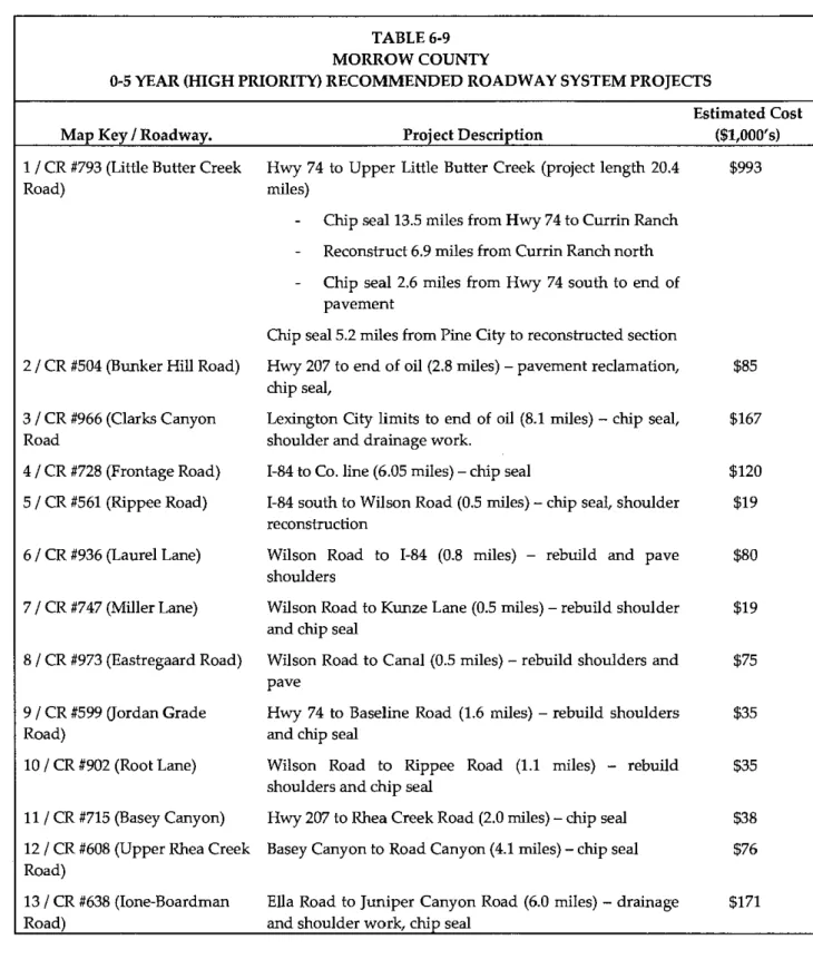
Construction projects in the latest STIP are shown in Table 3-4. These projects represent the County's major roadway and bridge construction projects over the next three years, and together represent an investment of about $30 million to be provided by a combination of public and private funding sources. Table 3-4 includes projects listed in the 2004-2007 approved STIP,
the 2006-2009 proposed STIP, and the OTIA III bridge delivery program. The Olson Road
overpass is also listed, which appears in the approved City of Boardman TSP. The overpass would provide access between the Port of Morrow and the City of Boardman.
Functional Classifications
The County's roadways are classified according to the function of each within the system. Functional classifications are shown in Figure 3-1. The County uses the following classifications based on the amount of traffic using a road or street and the origin and destination of the traffic:
Rural Arterial I Rural Arterial I1 Rural Collector I Rural Collector
II
Rural Collector 111 Rural Access I Rural Access I1Rural Gravel (proposed classification for gravel surface with a range of aggregate base requirements based on roadbed soil quality and existing traffic level)
Chapter 3 Existing Conditions and Inventory ....p 16
TABLE 3-4
PROGRAMMED IMPROVEMENTS IN MORROW COUNTY
Program Project Amount
Project Key Year Program Description Action (~1,000)
Port of
Morrow Rail New rail access;
13985 2005* 2004-2007 STIP Access Loop widen Columbia Blvd. $6,350
2006-2009 Draft Kunze Road Reconstruct roadway
13610 2008 STIP (OTIA 111) (Boardman) from Main to Tower $2,700
2006-2009 Draft Cutsforth Add restroom
14104 2007 STIP Park facilities 535
1-84 Irrigon Repair eastbound,
n/a n/a OTIA I11 Junction westbound bridges $9,800
City of Olson Road Construct overpass
n/a n/a Boardman TSP overpass over 1-84 $8-10,000
XEFERENCE: ODOT Approved 2004-2007 Statewide Transportation Improvement Program :STIF); ODOT Draft 2006-2009 STIP; City of Boardman Transportation System