CONTENTS
PAGE
FOREWORD BY EASTERN DIVISIONAL MANAGER iii
1.0 INTRODUCTION 1
2.0 STRATEGIC ROAD IMPROVEMENTS 9
2.1 York Street Interchange Scheme 10
2.2 A2 Sydenham Bypass Improvement Scheme 11
2.3 A55 Knock Road Improvement Scheme 11
3.0 NETWORK DEVELOPMENT 13
3.1 Minor Works 14
3.2 Bus Measures and Belfast Rapid Transit 14
3.3 Maintenance of Structures 15
3.4 Belfast On The Move 18
3.5 Belfast City Centre Ring-South Section 20
4.0 NETWORK TRAFFIC AND STREET LIGHTING 21
4.1 Collision Remedial Schemes 22
4.2 Traffic Schemes 22
4.3 Pedestrian Measures 24
4.4 Safer Routes to School 26
4.5 Traffic Signs 27
4.6 Carriageway Markings 29
4.7 Legislation 32
4.8 Disabled Parking Bays 34
4.9 Street Lighting 35
4.10 Cycle Measures 38
4.11 Traffic Calming 39
4.12 Car Parking 40
4.13 Residents’ Parking 41
5.0 NETWORK TRANSPORT TELEMATICS 43
5.1 Network Transport Telematics 44
6.0 NETWORK MAINTENANCE 47
6.1 Carriageway Resurfacing 48
6.2 Footway Resurfacing 50
6.3 Drainage 52
6.4 Public Realm 53
6.5 Streets Ahead Project 53
6.6 Liaison with Utilities 53
7.0 NETWORK PLANNING 55
7.1 Adoptions 56
FOREWORD BY THE EASTERN DIVISIONAL MANAGER
Kevin Monaghan
Divisional Manager
Mayor, Aldermen and Councillors
I am very pleased to present my Spring Report on TransportNI work to Belfast City Council.
Eastern Division now covers the two Council areas of Belfast and Lisburn & Castlereagh. It
is one of four Divisions, each of which manages, improves and maintains the transport
network and is the primary contact point for road users and public representatives.
This report deals with works completed in the Belfast City Council area during the year
2014/2015 and sets out our initial proposals for schemes to be undertaken in the year
2015/2016. The capital funding available for improvement schemes and road maintenance
is greatly reduced this year and there is very limited resource funding available for routine
maintenance activities. This will result in TransportNI only being able to provide a skeleton
routine maintenance service in most areas.
I am pleased to report that a wide programme of Local Transport and Safety Schemes was
delivered last year. I am also pleased to report that a large programme of maintenance
schemes was delivered in 2014/2015, through successful in-year monitoring bids, despite a
low level of funding being available at the start of the financial year.
I hope that you find this report informative. TransportNI values constructive comment on all
its activities and I look forward to meeting Council members on 10
thJune 2015.
Kevin Monaghan Divisional Manager Eastern Division ‘Hydebank’ 4 Hospital Road Belfast BT8 8JL
1.0 INTRODUCTION
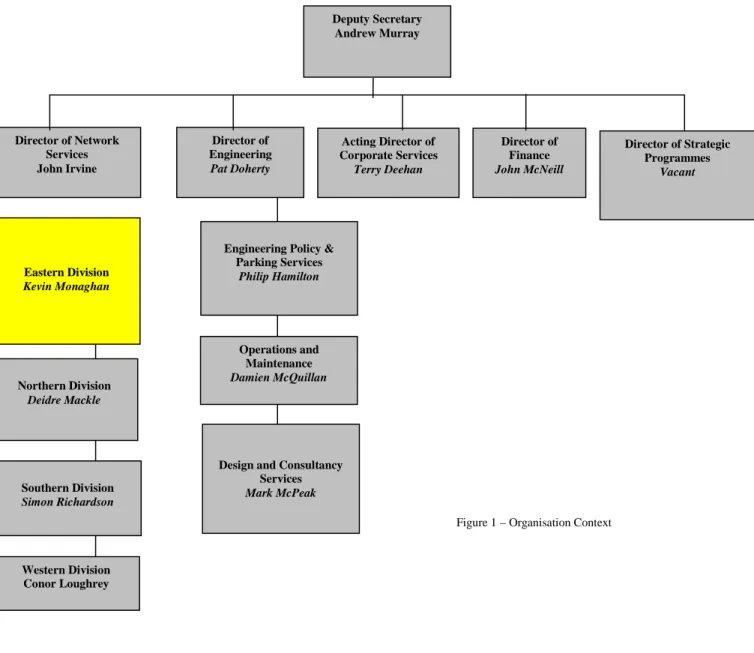
Eastern Division is part of the overall structure of TransportNI (see figure 1 below) which is based on separate business units for those who order services (clients) and for those who provide services (Design and Consultancy Services and Operations and Maintenance).
Figure 1 – Organisation Context
Deputy Secretary Andrew Murray
Engineering Policy & Parking Services
Philip Hamilton
Operations and Maintenance Damien McQuillan
Design and Consultancy Services Mark McPeak Northern Division Deidre Mackle Southern Division Simon Richardson Western Division Conor Loughrey Eastern Division Kevin Monaghan Director of Finance John McNeill Director of Engineering Pat Doherty Director of Network Services John Irvine Acting Director of Corporate Services Terry Deehan Director of Strategic Programmes Vacant
2
Colin Sykes (9025 3111) [email protected] Network Maintenance
Maintenance of adopted roads and footways including inspections, resurfacing, drainage, grass cutting and weed control, winter gritting and liaison with the utility companies.
Roy Spiers(9025 3002) [email protected] Strategic Route Improvements
Developing and progressing Strategic Highway Improvements within Eastern Division.
Stephen Pollock (9025 3071) [email protected] Network Development
Minor works programme, maintenance and strengthening of structures, QBC & bus priority, ‘Park and Ride schemes, Forward Planning, BoTM, and BRT infrastructure delivery.
Philip Robinson (9025 3080) [email protected] Network Planning
Development Control, Private Streets and Transport Assessments
Attracta Tremers (9025 3036) [email protected] Business Support
Financial control, land acquisition and disposal, retained human resources, building management and office supplies, council reports, business plan and communications.
Brian Maxwell (9025 4500) [email protected] Network Transport Telematics
Traffic signal control, operation of the Traffic Information and Control Centre, Traffic and travel information and European projects INSTANT and STREETWISE.
Norman Chambers (9025 3006)[email protected]
Network Traffic and Street Lighting
Traffic Management minor improvements, pedestrian priority, traffic orders, signing, collision remedial schemes, Street Lighting, resident and disabled parking, car parks and pay and display spaces, cycling and traffic calming.
Kevin Monaghan
(9025 3001) [email protected]Divisional Manager
Belfast City Council area – Key Statistics
Roads infrastructure Eastern Division Belfast City Council area
Length of public road (km)
2407
1091
Length of footway (km)
3063
2133
Number of bridges
395
133
Number of street lights
72629
45874
Number of car parks
46
33
Number of car parking spaces
3742
2736
WHAT WE DO
Maintaining the road network
Structural maintenance
Maintaining the network in a safe and serviceable condition remains one of our highest priorities. Structural maintenance includes:
The resurfacing and surface dressing of roads and footways
The repair of surface defects, such as potholes and broken flagstones The replacement and repair of road gullies, culverts and manholes Within the Eastern Division area in 2014/15 we:
Invested £14.8 million on structural maintenance resurfaced 102 lane km of the road network resurfaced 25 km of footways
Condition of the network
Monitoring the condition of our road network is an essential part of planning maintenance work and, in order to detect deterioration at an early stage, we undertake a number of annual road condition surveys using specialist vehicles to measure the strength, surface condition and skidding resistance of our roads.
In 2014/15 71.9% of the motorway and 76.8% of trunk road network had a residual life of more than 5 years compared to a target of 70% respectively. The information from the survey gives us an indication of areas of the road network which require further investigation and are likely to require maintenance.
Routine maintenance
Routine maintenance is important, both to enhance user safety and to help prevent more significant and costly maintenance problems building up over time.
In Eastern Division during 2014/15 we:
invested around £2.2 million replacing road markings, cutting grass verges to maintain visibility, emptying gullies and maintaining or replacing safety barriers, and maintaining street trees, verges and fences.
repaired 53,217 road defects following inspections.
Managing the road
We manage the road network to promote its safety and efficient operation. We have continued to make use of the latest technology and traffic management techniques to improve road safety, provide facilities for all road users, and effectively manage the network. This has included:
Monitoring and management of traffic signal timings
Responding to at least 97% of urgent traffic signal faults within 24 hours The use and extension of traffic control and monitoring systems
The promotion and introduction of Puffin crossings
The provision and management of motorway control systems The provision of accurate and reliable traffic information to the public Within Eastern Division during 2014/15 we:
• Completed the migration of the BusTrak system (Real Time Passenger Information) to a new operating platform to ensure its continued robustness and expandability.
• Installed real-time passenger displays in 15 metro bus shelters on the Lisburn Road, Belfast.
Provided pre-trip information on the trafficwatchni website, www.trafficwatchni.com,via radio broadcasts and our traffic information telephone line 08457123321. Carried out further enhancements to the trafficwatchni website to ensure its continued robustness and added information on Weight Restricted roads and the Strangford Lough Ferry Information to the website.
Replaced traffic signals at 2 signalised junctions.
Installed the advanced traffic signal control system, called MOVA (Microprocessor Optimised Vehicle Actuation), at 2 locations.
Commenced migration of the Urban Traffic Control Communications system (UTC) to a new operating platform to ensure its continued robustness and expandibility.
Winter Service
The aim of winter service is to help, as far as possible, main road traffic to move safely and freely in wintry conditions by spreading salt at the most effective times.
Eastern Division, has a fleet of 22 gritters and over 100 personnel available to salt approximately 1,239km of main roads.
There were 78 call-outs this year, using around 11,800 tonnes of salt, at a cost of approximately £15k per call-out to treat all roads on the salting schedule. Eastern Division completed 95% of winter salting actions within 4 hours, exceeding the target.
Emergency Response Service
We have procedures in place to assist with roads related emergency incidents to ensure a response, 24 hours a day, 7 days a week.
Our emergency response procedures are supported by a well established reporting system to gather operational information from across Northern Ireland during an emergency. A lead communicator is available out of hours all year round to ensure that the latest news on road conditions is available to the travelling public and we have enhanced the trafficwatch website to enable the lead communicator to keep this information updated including Social Media System and Twitter.
Development Control and Private Streets
Development Control staff act as consultee to DOE Planning, providing advice on road safety, traffic progression, transportation, roads layout/standards and policy compliance.
During the 2014/15 financial year, Eastern Division dealt with over 2,620 planning application consultations and processed an average 76% of these within 15 working days. (A 70% return is the target set in the Service Level Agreement with Planning Service).
In relation to new housing developments, 17.2km of Private Streets have been determined in 2014/15. This means that if and when the streets are built to the agreed layout and standard, they will be adopted into the public roads network.
61 new sites have started since April 2014 representing approximately 5km of new roads and footways. At 31 March 2015 we held £23.6M in bonds, and during 2014/15, £2.3M bonds were processed with £3.3M released on adoption.
Street Works
Our road network is a major public asset valued at over £32 billion. It accommodates a network of underground pipes and cables which deliver key services to the public including water supply, waste water disposal, electricity, gas and telecommunications.
Utility companies have the right to open the public road to place or maintain their equipment. In 2014/15 there were 48,666 utility company road openings across Northern Ireland, with some 15,708 in Eastern Division. We work closely with utility companies to minimise disruption caused by street works and ensure better quality reinstatements.
Our Inspectors in Eastern Division have carried out over 4,500 visits to streetworks sites to inspect work in progress and completed reinstatements.
Improving the Road Network
Major Road Improvements
The budget to the end of the 2015 Budget period will allow development work to continue on a range of other major projects which are of a higher priority. Delivery of these schemes is dependent on funding levels envisaged through the Investment Strategy for Northern Ireland 2011-21 and future budget settlements.
While the A2 Shore Road scheme now lies within boundary of the new Northern Division, Eastern Division has continued with the management of the construction of the scheme.
A2 Shore Road Greenisland – Work commenced on site in March 2013 and completion is expected in summer of 2015.
Within Eastern Division there are currently three road schemes being developed. These are the York Street Interchange, the A55 Knock Road and the A2 Sydenham Bypass.
York Street Interchange - Following the publication of the Statutory Orders for the York Street Interchange on 28th January and 4th February 2015, the Formal Consultation period ran until 10th March 2015. Following an assessment of the objections received, the Minister has announced that a Public Inquiry will be held in the Autumn of 2015 to hear the issues raised during the Consultation.
A55 Knock Road - Roads Service published the Notice of intention to Proceed and the Direction Order in September 2012 following the completion of a Departmental Statement. While there is currently no funding for this scheme, work can be progressed should additional funds become available.
A2 Sydenham Bypass – the preferred option for the scheme was published in February 2010. Scheme development work is ongoing.
The commencement of construction for the York Street Interchange, the A55 Knock Road and the A2 Sydenham Bypass will depend on the satisfactory completion of an economic assessment, completion of the statutory process and subject to funding being made available by the Executive in future budget settlements.
Bridge Strengthening
TransportNI regularly inspects its stock of bridges and other structures on the public road network.
Last year across Eastern Division we inspected 179 structures and carried out maintenance and repair work to 16 structures. In 2014/15 we spent a total of £188k on strengthening and maintaining our current stock of bridges, culverts and retaining walls.
Local Transport and Safety Measures
In 2014/15 we spent over £5.1million on a range of measures to improve the safety and efficiency of the road network. In Eastern Division this included implementation of:
24 Minor Works improvement schemes
6 Collision Remedial measures at specific sites 2 Traffic Calming measures;
0.2 kms of new cycle facilities 5 Safer Routes to School Schemes; 10 Controlled Pedestrian Crossings
0.52 kms of new/enhanced footway provision
Improvements to the trafficwatch website and the motorway control system as well as continuously ongoing work to improve the performance of our traffic signals and pedestrian controlled crossings.
Street Lighting
We provide and maintain street lighting on all adopted roads in urban areas and in certain circumstances, on rural roads.
In 2014/15 we spent £3.6 million installing new and maintaining existing lighting systems in Eastern Division. This excludes the energy costs which were £2.5 million.
Regrettably, because of budget constraints the Department is facing very significant resource pressures going into 15/16.
will only allow us to provide an in-house skeleton service for routine maintenance activities. We anticipate that we will only be able to repair around 25% of street light outages using our internal workforce.
We will prioritise our responses to deal with street lighting faults.
1. Priority will be given to faults that are posing an electrical hazard. 2. Secondly we will deal with with group outages.
3. Group day burners.
4. Unfortunately, single outages and single day burners, are a lower priority and may take some time to be repaired as they are being dealt with in chronological order.
Customer Service
TransportNI aims to inform, consult and involve customers by:-
supplying up-to-date information through our publications, at shows and exhibitions and via our website http://www.drdni.gov.uk and;
listening to customer needs; and
remaining open, transparent and visible at all times.
We publish a wide range of information leaflets on specific road schemes and on the services we provide. Our free newspaper, “On the Move”, is published twice a year and distributed through our local offices and public libraries.
We provide up-to-date travel news through our travel information website www.trafficwatchni.com and our traffic hotline for Greater Belfast on 08457 123321. Traffic information is updated at 10 minute intervals and broadcast on BBC Radio Ulster during peak times.
During the development phase of major roads projects, we consult with a wide range of stakeholders, including elected representatives and the public and, particularly, those likely to be directly affected by the works. We hold exhibitions at local venues and inform the public through press articles, leaflet drops and individual visits, as necessary.
During 2014/15 we received 4,579 written enquiries from the general public and responded to 93.8% of these within 15 days.
2.0 STRATEGIC ROUTE IMPROVEMENTS
Pri Principal Engineer – Roy Spiers(9025 3129)
[email protected]He is supported by the following staff:
Strategic Road Improvement 2 – Basil Hassard (9025 3272)
[email protected]
Basil is responsible for development of the A2 Shore Road dual
carriageway scheme, the M1 / A1 Link at Sprucefield and the
Sydenham By-pass scheme. Basil is supported by Bobby Murray
(ext 53232).
Strategic Road Improvement 1
–Colin Pentland (ext 53212)
[email protected]
Colin is responsible for progressing development of the York
Street Scheme and the A55 Knock Road widening. Colin is
supported by Colin McBurney (ext 53016)
2.1 YORK STREET INTERCHANGE SCHEME
The Westlink / York Street junction is a key link on the Strategic Road Network that presently connects Westlink and the M2 and M3 motorways through a complex traffic signal controlled gyratory system, which also connects with the local road network. This arrangement (and its high traffic usage) causes significant congestion and long delays, particularly at peak times. The recent improvements to the M1/Westlink and M2 Motorway also mean that traffic is now being delivered much more quickly to this junction.
In March 2009, Eastern Division completed the Preliminary Options Report, which assessed six options to grade separate the Westlink / York Street junction and provide direct links between Westlink and the M2 and M3 motorways. The Report recommended that four preliminary options be taken forward for further detailed consideration at the next stage of development, the Stage 2 Scheme Assessment. This work included a public consultation event into the scheme options at the Ramada Encore Hotel, Belfast A Ministerial Announcement was made on 6 December 2012 outlining the Preferred Option for the York Street Interchange at an event in the Ramada Encore Hotel.
Following this announcement, work on scheme design and preparation of the Statutory Orders was undertaken. The Draft Statutory Orders for this scheme were published on 28th January and 4th February 2015 following a Ministerial Announcement on 27th January 2015, with an Orders Exhibition being held in the Ramada Encore Hotel, Belfast on 9th and 10th February 2015. The Public Consultation period for the Orders ran until the 10th March and following due consideration, The Minister has announced that a Public Inquiry into the scheme will be held in the Autumn of 2015.
The timescale for construction of the new junction will be dependent upon the successful completion of the necessary statutory procedures, an economic appraisal and the provision of funding through the normal budgetary processes.
2.2 A2 SYDENHAM BYPASS IMPROVEMENT SCHEME
The A2 Sydenham Bypass is one of the most heavily trafficked carriageways in the Belfast Metropolitan Area and forms a vital section of the strategic highway network, linking Bangor and Belfast. The road also provides access to the key gateways of George Best Belfast City Airport, Belfast Port and to several large residential areas. The proposed scheme will widen a 2.5km stretch of the existing A2 Sydenham Bypass from a dual 2-lane carriageway to a dual 3-lane carriageway.
The scheme is currently in the third stage of a three stage assessment process. Stage 1 focused on identifying the environmental, engineering, economic and traffic advantages and disadvantages, as well as the constraints associated with broadly defined improvement strategies. This concluded in the selection of the Proposed Corridor in May 2008. In Stage 2, a detailed assessment of a range of options within the Proposed Corridor was considered. This concluded in the selection of the Preferred Option in February 2010. Stage 3, currently underway, involves detailed assessment of the Preferred Option and ongoing consultation with key stakeholders. This will result in the publication of the Statutory Orders; the draft Direction Order, Environmental Statement and Notice of Intention to Make a Vesting Order. The Budget for the current period should allow development work on Stage 3 to continue. Progress of the scheme beyond this is subject to the satisfactory outcome of the statutory processes and future years funding.
2.3 A55 KNOCK ROAD IMPROVEMENT SCHEME
The public inquiry for this scheme was held in November 2010. The Inspector’s Report, received in March 2011, made a number of recommendations and we carried out further traffic surveys and assessments in consideration of the report. The Inspector’s Report and a response to the Inspector’s recommendations have now been considered and included in the Departmental Statement. The Notice of Intention to Proceed and the Direction Order were published in September 2012.
The Department proposes to proceed with the scheme, however, there is no funding currently identified for its implementation. While the funding has not been identified, this is one of several schemes which the Department continues to progress to a procurement ready position should additional funding become available.
3.0 NETWORK DEVELOPMENT
Principal Engineer – Stephen Pollock (9025 3071)
[email protected]Bus Priority - Harry Armstrong (9025 3022)
This team is responsible for delivery of BRT Infrastructure, the Quality Bus Corridor (QBC) programme, other bus priority Measures and park and ride.
He is supported by the following staff:
Forward Planning Team 2- Stephen Gardiner (9025 3164) [email protected] This team is responsible for the development of schemes on the non-strategic route network through route improvement studies. It is also developing and progressing the management of the Belfast on the Move Transport Masterplan proposals for the City Centre and is a point of contact for Belfast Metropolitan Area Plan inquiries and Regeneration Initiatives.
Works and Structures - David Grills (9025 3153) [email protected] This team is responsible for major works, minor works and Structures.
3.1 MINOR WORKS 2015/16 Programme of Works
Scheme
Status
No Minor Works schemes are currently programmed. Councillors are invited to suggest improvement schemes for consideration.
3.2 BUS MEASURES 2014/15 Works Completed
Scheme
Status
Extension of the existing waiting restrictions at the coach lay-bys in Chichester Street and High Street from 6 days a week to seven days a week
Completed
Provision of Traffic Light Priority at the following junctions:-
• Newtownards Road at Dee Street
• Newtownards Road at Templemore Avenue
• Oxford Street at Lanyon Place
• Knocknagoney Road at Tillysburn
• Holywood Road at Parkway
Completed
Belfast Rapid Transit
Upper Newtownards Road (Sandown Road to Knock Road) - Carriageway widening, resurfacing and improvements to drainage and pedestrian crossing facilities.
Completed
BUS MEASURES 2015/16 Programme of Works
Scheme
Status
Belfast Rapid Transit
Albertbridge Road (Castlereagh Street to Newtownards Road) - Carriageway widening, resurfacing and improvements to drainage and pedestrian
crossing facilities.
Design work in progress.
Upper Newtownards Road (Albertbridge Road to Sandown Road) – Carriageway widening, resurfacing and improvements to drainage and pedestrian crossing facilities.
Design complete. Works
commenced May 2015
Scheme
Status
Upper Newtownards Road (Knock Road to Dunlady Road - Carriageway widening, resurfacing and improvements to drainage and pedestrian crossing facilities.
Design work in progress.
Divis St/ Falls Road (Millfield to Grosvenor Road) – Carriageway widening, resurfacing and improvements to drainage and pedestrian crossing facilities.
Design complete. Works due to commence on site July 2015.
Falls Road (Grosvenor Road to Whiterock Road) – Carriageway widening, resurfacing and improvements to drainage and pedestrian crossing facilities.
Works
commenced on site September 2014.
Falls Road /Andersonstown Road (Whiterock Road to Finaghy Road North) - Carriageway widening, resurfacing and improvements to drainage and pedestrian crossing facilities.
Design work in progress.
Andersonstown/Stewartstown Road (Finaghy Road North to Michael Ferguson Roundabout) -
Carriageway widening, resurfacing and improvements to drainage and pedestrian crossing facilities.
Design complete. Works due to commence on site Spring 2016
3.3 MAINTENANCE OF STRUCTURES 2014/15 Works Completed
Scheme
Status
Principal Inspections
Bridge No 20139 – Ballysillan Road Completed
Scheme
Status
Bridge No 20130 – Clowney Culvert Completed
Bridge No 20135 – Islandbawn St/Clowney Completed
Bridge No 20247 – Abington Street, Footbridge Completed
Bridge No 20189 – Sydenham By-Pass Completed
Bridge No 20222 – Lislea Avenue, Footbridge Completed
Bridge No 20234 – Blacks Road Rail Bridge Completed
Bridge No 20252 – Lisburn Road/University Road Completed
Bridge No 20253 – Botanic Avenue Completed
Bridge No 20254 – Ormeau Road, Railway Bridge Completed
Bridge No 20333 – Forthriver Primary School, Culvert Completed
Bridge No 20136 – Legoniel Rd (A) *Completed
Bridge No 20185 – Newtownards Rd/Connswater * Completed
Bridge No 20222 – Lislea Avenue footbridge * Completed
Bridge No 20247 – Abingdon Street footbridge * Completed
Concrete/Composite Structures
Bridge No 20179 - Bridge End Flyover – Repainting of Steel Parapets Completed Bridge No 20245 – Stockmans Lane, Subway – Defective Manhole Cover *Completed Bridge No – 20232 - Finaghy Rd North Bridge – Removal of offensive graffiti *Completed Masonry Structures
Stranmillis Retaining Wall – Concrete Repairs and Replacement of Metal Railings as part of an Environmental Improvement Scheme.
Substantially Complete
Bridge No 20261 - Ladas Way/Loop River – Parapet repairs *Completed
Bridge No 20126 – East Bridge Street – Fence repairs and debris removal *Completed Steel Structures
Bridge No 20189 - Sydenham By-Pass, Footbridge – Repairs to Handrails *Completed Bridge No 20251 – Lower Windsor Avenue – Repairs to defective handrail
sections *Completed
Miscellaneous
Forfar Road – Repairs to damaged section of metal fencing *Completed
Montgomery Rd/Sterling Avenue – Temporary repairs to collapsed culvert *Completed * Additional to programme
MAINTENANCE OF STRUCTURES 2015/16 Programme of
Inspections & Works
Scheme
Status
Bridge No 20124 – East Bridge Street (Road) Programmed
Bridge No 20126 – East Bridge St(ACCOM) Programmed
Bridge No 20129 – Sunningdale Park Programmed
Bridge No 20162 – Ann St Subway Programmed
Bridge No 20194 – High St Subway Programmed
Bridge No 20180 – Tillysburn Underpass at city Airport Programmed
Bridge No 20185 – Newtownards Rd / Connswater Programmed
Bridge No 20188 – Victoria Pk S’Way Programmed
Bridge No 20191 – Tillysburn S’Way A Programmed
Bridge No 20192 – Tillysburn S’Way B Programmed
Bridge No 20193 – Tillysburn S’Way C Programmed
Bridge No 20195 – North Rd Bridge Programmed
Bridge No 20241 – Lisburn Road Programmed
Bridge No 20242 – Boucher Crescent 1 Programmed
Bridge No 20243 – Boucher Crescent 2 Programmed
Bridge No 20244 - Glenmachan Place Programmed
Bridge No 20245 – Stockmans Lane Subway Programmed
Bridge No 20249 – Fane St.FootBridge Programmed
Bridge No 20250 – Tates Ave Bridge Programmed
Bridge No 20256 – Kings Bridge Programmed
Bridge No 20259 – Beersbridge Road Programmed
Bridge No 20261 – Ladas Way/Loop River Programmed
Bridge No 20263 – Grand Parade Programmed
Bridge No 20264 – Orby Link Bridge Programmed
Bridge No 20266 – Knockvale Grove Programmed
3.4 BELFAST ON THE MOVE
The Belfast on the Move project was undertaken by the Department to help create a more accessible city centre. By reorganising traffic management in Belfast city centre, the project set out to encourage greater walking, cycling and public transport use in line with the aims of the Belfast Metropolitan Transport Plan.
The project has delivered:
• Over 2.6km of new bus lanes, which also accommodate cyclists and permitted
taxis;
• A new ’two-way’ traffic flow in Hope Street ;
• 23 new controlled pedestrian crossing points;
• 340m of new dedicated service bays;
• 0.5km of new dedicated cycle lanes; and
• 37 additional dedicated disabled parking bays
‘Before’ and ‘after’ surveys were undertaken to assess the impact of the project in relation to its main aims:
• a more accessible city
• a reduction in general traffic levels
The analysis of the surveys shows that since the traffic management changes were completed in October 2013:
The city centre is more accessible:
• An increase of over 6% in the number of people entering the city centre in the morning peak.
• This is over 2,200 additional people.
There has been a reduction in general traffic levels in the city centre:
• An average reduction of over 1,900 in the number of vehicles entering the city centre core area during the morning peak.
• An average reduction of around 10,900 in the number of vehicles entering the city centre core area over a 24 hour period.
There has been an increase in walking:
• An increase of over 12% in the number of pedestrians entering the city centre during the morning peak.
There has been an increase in cycling:
• An increase of over 18% in the number of cyclists entering the city centre during the morning peak.
There has been an increase in public transport use:
• An increase of over 36% in the number of rail passengers entering the city centre during the morning peak.
• An increase of over 17% in the number of bus passengers entering the city centre during the morning peak.
A comparison of the ‘before and after’ survey data also revealed the following: In the morning peak (08:00 – 09:00):
• An increase of over 6% in the number of people entering the city centre.
• A decrease of over 4% in the number of people entering the city centre by private car.
• More than half (53%) of the people entering the city centre in October 2013 did so using public transport, taxis, walking or cycling – compared to less than half (47.3%) in 2011.
In an average 24 hour period:
• Almost 11,000 fewer vehicles entering the core city centre streets
• Associated reductions in traffic flows through inner city residential areas. Public transport patronage
• An increase of around 2% in the annual number of public transport journeys – 77 million in 2011/12 to 78.5 million in 2012/13.
• A further annual increase of around 2% to over 80 million public transport journeys in 2013/14.
Car parking
• The number of cars parking in Belfast city centre has increased by more than 500 on weekday mornings and by more than 1,000 on Saturday mornings.
Based on the results set out in the Report, the Belfast on the Move project has been a success in that it has met its main aims of making Belfast a more accessible city, reducing general traffic levels in the city centre and encouraging greater walking, cycling and public transport use.
3.5 BELFAST CITY CENTRE RING – SOUTH SECTION
TransportNI, Eastern Division has been developing proposals for road improvements along the south section of the City Centre Ring. This scheme will be much reduced in scale from that proposed in the Belfast Metropolitan Transport Plan (BMTP). It will focus on the needs of public transport, pedestrians and cyclists, as well as general traffic, and take cognisance of potential redevelopment opportunities.
An acceptable road ‘footprint’ would identify a number of viable and attractive sites for
redevelopment to the south of the office district, between Sandy Row and Cromac St, and help to remove the blight that this area has suffered for many years.
4.0 NETWORK TRAFFIC AND STREET LIGHTING
Principal Engineer – Norman Chambers (9025 3006)
[email protected]Street Lighting - David Wright (9025 3057)
[email protected]
This team is responsible for Street Lighting, traffic bollards
and the illumination of signs.
Traffic Management 1 - Roy Gordon (9025 3007)
[email protected]
This team deals with traffic improvement schemes in
Belfast.
Traffic Management 2 - Graeme Salmon (9025 3026)
[email protected]
This team deals with traffic improvement schemes in Lisburn
and Castlereagh and collision remedial schemes in all
council areas.
He is supported by the following staff:
Traffic Management 3 - Paul King (9025 3029)
[email protected]
This team is responsible for residents’ parking,
development of car parking, cycle measures and
traffic calming.
4.1 COLLISION REMEDIAL SCHEMES 2014/15 Works Completed
Scheme
Status
Upper Springfield Road / Hannahstown Hill Completed
Millfield / Wilson Street Completed
Ormeau Road / Annadale Embankment Completed
COLLISION REMEDIAL SCHEMES 2015/16 Programme of Works
Scheme
Status
A2 Shore Road / Fortwilliam Park In Progress
4.2 TRAFFIC SCHEMES 2014/15 Works Completed
Scheme
Status
Finaghy Road South, between Erinvale Avenue & Upper Malone Road –
Channelisation (central carriageway hatching & edge of carriageway lines) Completed
Scheme
Status
Oxford Street at May Street – Amend road layout Completed
Shore Road at Donegall Park Avenue – New right turn filter for traffic signals Completed
Shore Road at Donegall Park Avenue – right turn filter
Springfield Road – upgrade of zebra crossing Completed
Upper Lisburn Road / Finaghy Crossroads – Fully controlled right turn
facilities at traffic signals Completed
TRAFFIC SCHEMES 2015/16 Programme of Works
Scheme
Status
Scheme
Status
Glen Road / Suffolk Road - signalisation In Abeyance
Oldpark Road at Torrens Avenue – Build-out and road markings Programmed
Whitewell Crescent at Serpentine Road – Amendment to junction layout Programmed
4.3 PEDESTRIAN MEASURES 2014/15 Works Completed
Scheme
Status
Alfred Street - Pedestrian crossing points / lowered kerbs & tactiles Completed
Bell’s Bridge Roundabout – Zebra crossings upgrade Completed
Brown’s Square – Pedestrian crossing points / lowered kerbs & tactiles Completed Circular Road - Pedestrian crossing points / lowered kerbs & tactiles Completed Dundela Avenue at North Road – Refuge island & footway widening Completed
Scheme
Status
East Bridge Street - Pedestrian crossing points / lowered kerbs & tactiles CompletedFalls Road at Beechview Park – puffin crossing Completed
Hawthornden Way – puffin crossing Completed
Hawthornden Way – Puffin crossing
Library Street - Pedestrian crossing points / lowered kerbs & tactiles Completed
Ravenhill Road near Rosetta Park – relocate traffic island Completed
Sandown Road at King’s Road – footway improvement Completed
Springfield Road at Cupar Street – change zebra crossing to puffin crossing Completed Suffolk Road near Old Suffolk Road – relocation of a pedestrian refuge island Completed Upper Lisburn Road at Balmoral Golf Course – remove traffic island Completed Willowfield Street - Pedestrian crossing points / lowered kerbs & tactiles Completed
PEDESTRIAN MEASURES 2015/16 Programme of Works
Scheme
Status
Botanic Avenue at College Park – puffin crossing In Progress
Castlereagh Road at Montgomery Road – additional pedestrian phase Programmed
Crumlin Road at Mountainview Park – puffin crossing Programmed
Crumlin Road at Ardoyne Library – puffin crossing Programmed
Fortwilliam Park at Dominican College – puffin crossing Programmed
Fortwilliam Park near Dunlambert Park – pedestrian island In Progress
Lisburn Road at Fountainville Ave (The Bradbury Centre) – puffin crossing Programmed
Milltown Road at Belvoir Drive – pedestrian upgrade In Progress
Oldpark Road at Oldpark Terrace – puffin crossing and channelisation In Abeyance Shankill Road - Pedestrian crossing points / lowered kerbs & tactiles In Progress
Tate’s Avenue at Ebor Street – puffin crossing Programmed
Upper Lisburn Road near Kirklowe Drive – puffin crossing In Progress
4.4 SAFER ROUTES TO SCHOOLS 2014/15 Works Completed
Scheme
Status
Belvoir Park Primary School, Belvoir Drive Completed
Elmgrove Primary School, Beersbridge Road Completed
Holy Child Primary School, Andersonstown – Safer Routes to Schools
Springfield Primary School, Springfield Road Completed
Saint Rose’s High School, Beechmount Avenue Completed
SAFER ROUTES TO SCHOOLS 2015/16 Programme of Works
Scheme
Status
Requests for Safer Routes to Schools will be assessed and prioritised On-going
4.5 TRAFFIC SIGNS 2014/15 Works Completed
Scheme
Status
A55 Milltown Road – 50mph repeater signs Completed
Scheme
Status
Ballynahatty Road – ‘Pedestrians on road ahead’ and ‘Junction on left’ signs’ CompletedBallyutoag Road – 50mph speed limit signs Completed
Barrack Street – waiting restriction signs Completed
Castle Place – ‘Bus Tours’ signs Completed
Church Avenue at Malone Gardens, Dunmurry – New ‘Stop’ sign Completed
Connswater Street near Newtownards Road – warning signs for elderly
pedestrians Completed
Creighton Road – 50mph repeater signs Completed
Donegall Square South – laning signs Completed
Donegall Square South – laning signs
Dundela Avenue – waiting restriction plates Completed
Dunmurry Lane – 40mph speed limit signs Completed
Durham Street – waiting restriction plate Completed
Ebor Street – new ‘One Way’ arrow signs Completed
Scheme
Status
Gardiner Place – waiting restriction plate Completed
Greenville Street – waiting restriction time plate Completed
Hamill Street – waiting restriction plates Completed
Hawthornden Way – upgrade of 40mph repeater signs Completed
Holywood Road, Milltown Road & Sunnyside Street – direction signage for
Army Reserve Centres Completed
King’s Road – hazard warning sign Completed
Mount Eagles Avenue and Crescent – ‘Playground’ warning signs and plates Completed Peter’s Hill at Townsend Street – direction signage for Townsend Enterprise
Park & Townsend Presbyterian Church Completed
Rutherglen Street – 2 no. ‘Children/School’ signs Completed
Stewart Street – ‘Playground’ warning signs and plates Completed
Short Strand in lay-by – limited waiting signs Completed
Tomb Street – limited waiting signs Completed
TRAFFIC SIGNS 2015/16 Programme of Works
Scheme
Status
Belfast Signing Strategy - Direction Signage for City Centre / Inner City &
Arterial Routes In Progress
Stranmillis area – Upgrade of existing direction signage In Progress
Sydenham Bypass at Dee Street – new direction sign In Progress
4.6 CARRIAGEWAY MARKINGS 2014/15 Works Completed
Scheme
Status
Alexandra Park Avenue – revocation of double yellow lines Completed*
Alloa Street at entrance to play park – 3 no. Sections of pedestrian guard rail Completed
Scheme
Status
Baltic Avenue - waiting restriction Completed*
Bilston Road at Crumlin Road – corner restrictions Completed
Boucher Place at Boucher Crescent – corner restrictions Completed
Blythe Street – ‘I’ bar marking Completed*
Cairnburn Road at Old Holywood Road / Glenmachan Road – warning lines
on approach to junctions Completed
Castlereagh Road, Tesco store to Ormonde Gardens – improvements to and
extending of central hatching / right turn pockets Completed
Cavehill Road – 4 no. ‘I’ bar markings Completed*
Cavehill Road – yellow box junction markings Completed*
Clifton Street – waiting restriction Completed*
Cromac Street at East Bridge Street – yellow box junction Completed
Crumlin Road at White Brae – edge of carriageway markings Completed
Deramore Park South at Malone Road – ‘Give Way’ junction markings Completed Dock Street at Garmoyle Street – hatched nose markings at end of island Completed Donegall Square North at Linenhall Street – extension of yellow box junction Completed Divis Street at Millfield – 2 no. ‘Straight ahead’ arrows & 1 no. ‘turn right’ Completed
Dundela Avenue at North Road – junction markings Completed*
Dunluce Avenue at Lisburn Road – 3 no. hazard markings Completed*
Eastleigh Drive at Library Court – new hatched markings at car-park entrance Completed
Finaghy Road South – central hatching Completed*
Finbank Gardens – 2 no. sections of pedestrian guard rail Completed*
Fitzwilliam Avenue at Ormeau Road – corner restrictions Completed
Gardiner Place – waiting restriction Completed*
Glenmachan Place at Boucher Road – corner restrictions Completed
Gransha Avenue at Glen Road – corner restriction Completed*
Harrisburg Street & Pittsburg Street, Shore Road – corner restrictions Completed
Iveagh Drive – waiting restrictions (double yellow lines) Completed
Scheme
Status
Kings Road – extension to yellow box marking and ‘Slow’ marking Completed*
Kings Street Mews – waiting restriction Completed*
Knock Road at PSNI HQ – yellow box marking Completed*
Knocknagoney Drive at Community Centre – on-street parking spaces
marked Completed
Ligoniel Road at Saint Vincent de Paul Primary School – pedestrian guard
rail installed Completed
Lislea Avenue – across alleyway ‘I’ bar road marking Completed
Lockview Road - ‘end of parking’ marks Completed
Massey Avenue – waiting restrictions Completed
Massey Avenue at Stormont Estate – corner restrictions and bay markings Completed
Orby Link – waiting restrictions Completed*
Ormeau Road – Cromac Place to Cooke Street – waiting restrictions (double
yellow lines) Completed
Ormeau Road at Annadale Avenue – re-alignment of lane markings Completed*
Mount Eagles, Dunmurry – ‘Give Way’ junction markings and warning lines Completed
Ravenhill Road (link to Albert Bridge) – corner restriction Completed*
Regent Street at Denmark Street – corner restrictions, central hatching and
edge of carriageway markings Completed
Renfrew Street at Fletcher Street – ‘I’ bar marking Completed*
Roden Street/Lemberg Street – 4 no. Sections of pedestrian guard rail Completed*
Roden Street at Distillery Street – corner restriction Completed*
Rocky Road at Upper Knockbreda Road – corner restrictions Completed
Rosehead, Oldpark area – ‘Give Way’ junction marking and warning lines Completed
Saint John’s Avenue – ‘I’ bar marking Completed*
Saint John’s Avenue at Ormeau Road – bollards installed at back of footway Completed
Seymour Lane at Seymour Street – corner restrictions Completed
Short Strand near Albert Bridge – waiting restriction Completed*
Tomb Street – limited waiting Completed*
Scheme
Status
University Avenue – ‘I’ bar marking Completed*
Upper Galwally at Saintfield Road – new lane guideline marks Completed
Upper Knockbreda Road at Cregagh Road – lane/guide lines through junction
Completed* Upper Knockbreda Road (near Knockbreda High School) – extension to lane
markings
Completed*
Upper Newtownards Road at Astoria Gardens – hatched marking in lay-by Completed
Upper Riga Street – ‘School Keep Clear’ marking Completed
Wandsworth Road at Belmont Road – waiting restrictions Completed*
Woodstock Place – waiting restrictions Completed*
*Additional to programme
CARRIAGEWAY MARKINGS 2015/16Programme of Works
Scheme
Status
Road markings will be provided as required On-going
4.7 LEGISLATION 2014/15 Works Completed
Scheme
Status
WAITING RESTRICTIONS
Alexandra Park Avenue near Dunmore Drive – Revocation of a section of
double yellow lines Completed
Balfour Avenue – Mon – Sat 8.00am to 6.00pm Completed
Baltic Avenue – At Any Time Completed
Barrack Street – Mon – Sat 8.00am to 6.00pm Completed*
Scheme
Status
Crumlin Road, near Mater Hospital – At Any Time Completed
Crumlin Road near Stanhope Street – At Any Time Completed
Durham Street – Mon - Sat 8.00am to 6.00pm Completed
Gardiner Place – Mon - Sat 8.00am to 6.00pm Completed
King Street Mews – At Any Time Completed*
Massey Avenue – At Any Time Completed
North Queen Street – Mon - Fri 8.00am to 6.00pm Completed
Orby Link – At Any Time Completed
Tomb Street – Mon – Fri 8.00am to 6.00pm, waiting limited to 1 hour, return
prohibited within one hour Completed
Wandsworth Road – At Any Time Completed
Woodstock Place – At Any Time Completed
TRAFFIC ORDERS
Artana Street, Dromara Street & Kinallen Street – One way traffic system Completed
Ballyutoag Road / Upper Crumlin Road – new ‘50mph’ speed limit Completed
Dunmurry Lane – new ‘40mph’ speed limit Completed
Newington Avenue & Newington Street – One way traffic system Completed
*Additional to programme
LEGISLATION 2015/16 Programme of Works
Scheme
Status
WAITING RESTRICTIONS
Cadogan Park – At Any Time Programmed
Claremont Street – At Any Time In Progress
Exchange Place – At Any Time Programmed
Walnut Street – At Any Time Programmed
Scheme
Status
TRAFFIC ORDERSBelfast City centre – Proposed ‘20mph’ speed limit In Progress
Fairhill Park – One way traffic system In Progress
Mount Eagles Square – One-way traffic system In Progress
4.8 DISABLED PARKING BAYS 2014/15 Works Completed
Scheme
Status
24 Ardenlee Gardens, Belfast Completed
75 Cedar Avenue, Belfast Completed
17 Clarendon Gardens, Belfast Completed
19 Fernwood Street, Belfast Completed
86 Mountcollyer Avenue, Belfast Completed
88 Roseberry Road, Belfast Completed
27 Stranmillis Park, Belfast Completed
270 Tennent Street, Belfast Completed
101 Tildarg Street, Belfast Completed
27 Larkfield Gardens, Belfast Completed
59 Oberon Street, Belfast Completed
12 Ohio Street, Belfast Completed
22 Wheatfield Gardens, Belfast Completed
Bays removed:
15 Glandore Gardens Completed
16 Willowfield Parade Completed
12 Ohio Street, Belfast Completed
Scheme
Status
13 Rugby Road Completed
20 College Park Avenue Completed
DISABLED PARKING BAYS 2015/16 Programme of Works
Scheme
Status
49 Fairhill Park Programmed
45 Lomond Avenue Programmed
56 Wilgar Street Programmed
54 Jocelyn Street Programmed
12 Sinclair Street Programmed
78 Belmont Road Programmed
13 Castleview Terrace Programmed
14 Holland Drive Programmed
45 Veryan Gardens Programmed
32 Ardcarn Drive Programmed
12 Knocknagoney Park Programmed
61 Ulsterville Gardens Programmed
11 Eastleigh Crescent Programmed
19 Tynedale Green Programmed
27 Newington Avenue Programmed
4.9 STREET LIGHTING 2014/15 Works Completed
Scheme
Status
Scheme
Status
Suffolk Road Completed
Ormonde Gardens Completed
Willisfield Park / Gardens / Avenue Completed
Wedderburn Park / Gardens / Avenue Completed
Rathmore Park / Gardens Completed
Percy Street Completed
Bristow Park Completed
Cupar Street Lower Completed
Deramore Drive / Crescent Completed
Chadwick Street Completed
Ardavon Park Completed
Ardavarna Park / Crescent Completed
Ascot Park / Gardens Completed
Ventry Street Completed
Belmont Park Completed
Belmont Drive Completed
Seaview Gardens / Seamount Completed
Balholme Drive Completed
Norglen Gardens Completed
York Park Completed
Iris Drive Completed
Fairway Gardens / Avenue Completed
Berwick Road Completed*
Balholme Drive Completed*
Windsor Drive Completed*
Deramore Park South Completed*
Scheme
Status
Gainsborough Drive Completed*
Florence Court/Walk/Drive Completed*
Forfar Street Completed*
Forest street Completed*
Fort Street Completed*
Duffield Park Completed*
Hazelbrook Drive Completed*
Myrtlefield Park Completed*
Green Road Completed*
Knock Dual Carriageway Completed*
Ormiston Gardens Completed*
*Additional to programme
STREET LIGHTING 2015/16 Programme of Works
Scheme
Status
Blacks Road Programmed
Mountforde Drive/Road Programmed
Agnes Street Programmed
Cregagh Estate Ph1 & Ph2 Programmed
Robina Street Programmed
Leopold Street Programmed
Parkway Programmed
Harrowgate Street Programmed
Scheme
Status
Iris Street Programmed
Forthriver Way Programmed
Whitla Street Programmed
Herbert Street Programmed
Springfield Road (Monagh Road Junction) Programmed
Duncrue Street (Whitla Street underpass) Programmed
Northland Street Programmed
Lenadoon Avenue Ph1 & Ph2 Programmed
Kingswood Street Programmed
Lord Street Programmed
New Lodge Road Programmed
Markets Area Ph1 & Ph2 Programmed
Osbourne Gardens *Programmed
Governors Bridge *Programmed
Halidays Road *Programmed
Belmont Church Road *Programmed
4.10 CYCLE MEASURES 2014/15 Works Completed
Scheme
Status
Milewater Road footbridge - Wheeling ramps *Completed
Sandown Road at Greenway - Toucan Crossing Completed
A55 Milltown Road - Toucan Crossing **Completed
*Additional to 2014/15 Programme
CYCLE MEASURES 2015/16 Programme of Works
Scheme
Status
A2 Bridge End on Queens Bridge Belfast – New Toucan Crossing
*Programmed A2 Queen Elizabeth Bridge - Upgrade to Toucan Crossing
*Programmed Albertbridge Road – cycle lanes and cycle track.
*Awaiting signage Alfred Street / Upper Arthur Street cycleway
Programmed Castle Street/ Donegall Place to Middlepath Street cycleway
Programmed College Avenue to Castle Street/ Donegall Place cycleway
Programmed Duncrue Street – New Toucan Crossing
*In progress Various locations - Sheffield cycle stands
*In progress Westlink /Grosvenor Road to College Avenue cycleway
Programmed Whitla Street at Nelson Street underpass–Upgrade to Toucan Crossing
*In progress *Carried over from 2014/15 Programme.
4.11 TRAFIC CALMING 2014/15 Works Completed
Scheme
Status
TRAFFIC CALMING 2015/16 Programme of Works
Scheme
Status
Belvoir Drive – Traffic Calming Scheme Construction work
ongoing. To be completed May 2015.
Flax Street - Traffic Calming Scheme *DOJ to provide funding
Glenburn Road & Ulster Avenue – Traffic Calming Scheme * Objections received and under consideration.
Sicily Park area - Advisory 20mph Zone Signs to be erected in May
2015.
Whitewell Crescent & Parade – Traffic Calming Modifications Legislative process successfully completed. No funding available to proceed with the works at present.
*Carried over from 2014/15 Programme.
It should be noted that all Traffic Calming schemes are subject to a legislative process and to the availability of funding before they can proceed.
The legislative process provides for representations / objections to be received on our proposals. Where residents do not support individual schemes or where objections are received, it may not be possible to deliver our intended programme. In this event substitutions, on a Division-wide basis, may be made throughout the financial year.
4.12 CAR PARKING 2014/15 Works Completed
Scheme
Status
Motorcycle Parking We continued to develop the design of and
drafting of the legislation for free on-street parking bays for motorcycles in several locations in Belfast City Centre.
Provision of additional On-Street Pay and Display spaces as identified.
A letter has been sent to Council indicating the streets where we propose providing additional on-Street Pay and Display parking.
Review of our off and on-street parking charges.
We noted any necessary remedial actions and these were attended to on a priority basis.
Scheme
Status
Car Park Management We are working closely with Council officials to
ensure the smooth transfer of management responsibility to the Council.
Motorcycle Parking We will proceed to formal consultation this Autumn.
Provision of additional On-Street Pay and Display spaces as identified.
We await a reply from Council and an indication of support before we progress with this issue.
4.13 RESIDENTS’ PARKING
The formal consultations for the Lower Malone and the College Park Avenue/Rugby Road areas were carried out between 29 October 2014 and 19 November 2014. During this time we received a significant number of objections and representations on the two proposals.
Officiers met with objectors throughout March 2015 and the issues which they raised are now being considered with a view to deciding on the way forward. It is envisaged the earliest a scheme could be implemented on the ground in these areas would be towards the end of the 2015/2016 financial year, although this is very much dependent upon there being a positive outcome of a further consultation process.
5.0 NETWORK TRANSPORT TELEMATICS
Principal Engineer – Brian Maxwell (9025 4500)
[email protected]He is supported by the following staff:
TICC’s TrafficwatchNI website
James Middleton (90254529)
[email protected]
This team has specific responsibilities for issues of Road
Safety including the development of the Road Safety
Engineering Report and the establishment of Central Road
Safety Unit. It is also responsible for compiling traffic census,
vehicle kilometre travel surveys and managing the road works
website
.Declan Murphy (9025 4536)
[email protected]
This team is responsible for the day to day running of the
Traffic Information and Control Centre. It is responsible
for the installation, maintenance and operation of Intelligent
Transport Systems (ITS) including traffic control
on the urban and motorway networks and the provision of
traffic and travel information.
5.1 NETWORK TRANSPORT TELEMATICS 2014/15 Works Completed
Scheme
Status
TRAFFIC AND TRAVEL INFORMATION
We will continue to enhance the trafficwatchni website and improve our social media facilities as appropriate.
8 No. M2 foreshore Variable Message Signs (VMS) have been upgraded to ensure their continued effectiveness.
Ongoing
Complete
URBAN CLOSED CIRCUIT TELEVISION (CCTV) CAMERAS
Review CCTV coverage to ensure its continued adequacy and identify camera locations that are in need of upgrade.
Ongoing
TRAFFIC SIGNALS
We will monitor traffic signal timings to ensure they are appropriate for the prevailing traffic conditions and subject to adequate funding we will upgrade traffic signal equipment where necessary.
Replacement of Traffic Signals Blacks Road / M1 On-Slip. This work is currently on site and should be substantially complete by end of March 2015. Migrate traffic signals to utilise IP (internet protocol) based communications between site and Traffic Information and Control Centre
Implement MOVA, an advanced form of traffic signal control, at Antrim Road / North Circular Road.
Ongoing
Ongoing
Commenced
Ongoing MOTORWAY COMMUNICATIONS AND CONTROL
Utilise TICC’s motorway communications & control infrastructure together with CCTV traffic monitoring facilities to efficiently manage traffic on motorways and the Westlink.
Ongoing
CENTRAL ROAD SAFETY UNIT
This unit will continue to have a strategic overview of road safety and the analysis of collision data on roads across the Province.
Installation of additional permanent traffic counting sites.
Ongoing
Deferred due to contract issues.
NETWORK TRANSPORT TELEMATICS 2015/16 Programme of Works
Scheme
Status
TRAFFIC AND TRAVEL INFORMATION
We will continue to enhance the Trafficwatchni website and improve our social media facilities as appropriate.
Ongoing
URBAN CLOSED CIRCUIT TELEVISION (CCTV) CAMERAS
Review CCTV coverage to ensure its continued adequacy and identify camera locations that are in need of upgrade.
Ongoing
Identify new locations where the provision of cameras will enhance the coverage of the CCTV network, to improve traffic control capabilities.
Ongoing
TRAFFIC CONTROL SYSTEMS
Utilise TICC’s communications and control infrastructure together with the CCTV network to ensure traffic flows are monitored and effectively managed on the urban and motorway networks.
Ongoing
We will monitor traffic signal timings to ensure they are appropriate for the prevailing traffic conditions.
Ongoing
Subject to adequate funding be made available we will upgrade traffic signal equipment as required.
Ongoing
Provide increased resilience to the traffic control system by migrating traffic signals to utilise more reliable IP (internet protocol) based communications
Ongoing
CENTRAL ROAD SAFETY UNIT
This unit will continue to have a strategic overview of road safety and the analysis of collision data on roads across the Province.
6.0 NETWORK MAINTENANCE
Principal Engineer – Colin Sykes (9025 3111) [email protected]
He is supported by the following staff:
Belfast North Section Engineer – Brian O’Neill
(9025 4044)
[email protected]
148 – 158 Corporation Street, Belfast, BT1 3DH
This team is responsible for contacts with the public and
elected representatives, highway inspections, resurfacing,
responsive repairs, routine maintenance, winter gritting,
road opening consents and licences, public liability claims
and liaison with the service utility companies.
Maintenance Support Engineer- Trevor McClay
(9025 3098) [email protected]
This team is based at Hydebank and is responsible
for general co-ordination, bidding, allocating and
monitoring finances, maintenance of safety
fences, contract monitoring, statistics and
enforcement.
Belfast South Section Engineer - Gareth McKibbin
(9025 4609
)
[email protected]
1a Airport Road, Belfast, BT3 9DY
(As Belfast North below)
6.1 CARRIAGEWAY RESURFACING 2014/15 Works Completed
Scheme
Status
BELFAST SOUTH
From April 2014 to March 2015, 15.69km of carriageway has been resurfaced in the Belfast South area. This equates to 60890sqm and includes the schemes listed below.
Middlepath Street/ Bridge End - Part Completed
Cyprus Avenue Completed
Bloomfield Road Completed
Donegall Road – Shaftesbury Square to Euterpe Street Completed
Sandown Road - Part Completed
Bell’s Bridge Roundabout Completed
Lord Street/Constance Street Completed
Kinedar Crescent/ Pirrie Road Completed*
Ballymiscaw Road - part Completed*
Bridge End – Dalton Street to Queen’s Bridge Completed*
Sharman Road Completed*
Gilnahirk Road - Part Completed*
A55 Knock Road - Part Completed*
BELFAST NORTH
From April 2014 to March 2015, 20.15km of carriageway has been resurfaced in the North Belfast area. This equates to approximately 80,347sqm and includes the completed schemes listed below.
Azalea Gardens Completed*
Almond Drive Completed*
Ben Madigan Park Completed
Bradbury Place Completed
Castle Park Completed*
Colin Glen Road Completed
Duncrue Crescent Completed*
Duncrue Street Completed*
Forthriver Road Completed
Garvey Glen Completed*