Spatial Multi-Criteria Decision Process
to Define Maintenance Priorities of Forest
Road Network: an Application in the Italian
Alpine Region
Marco Pellegrini, Stefano Grigolato, Raffaele Cavalli
Abstract – Nacrtak
The combination of GIS tools and Analytic Hierarchy Process (AHP) techniques is used to develop a Decision Support System to rank the maintenance priorities of a forest road network according to the actual conditions and needs. The decision-making process is divided into 4 stages. The first stage fixes the objectives of the analysis as the minimization of the sediment production from road surface and the maximization of the social value of the road. The second stage defines the hierarchical structure of the decision problem. At this stage the set of factors (criteria) to maximize each objective and the evaluation methods are defined. At the third stage AHP analysis is applied using a specific application running on ArcGIS, to calculate the evaluation layer that represents the importance of each road according to the set objectives. The values of the evaluation layer are used at the fourth stage to rank the maintenance inter-ventions according to the given benefit. The methodology has been tested in a forest road network with an extension of 107.8 km including in the analysis the real budget constraints and maintenance costs.
The results show that the integrated use of GIS and AHP analysis represents a valuable tool to rate the importance of the forest road network for the management of a mountain territory and to define priorities among maintenance operations of the road network, in order to maxi -mize the overall benefit with limited economic resources.
Keywords: forest road maintenance, maintenance cost, AHP, GIS, Decision Support System
and environmental goals. The resulting task is com -plex because of the many aspects involved in forest road management, including the natural environment and the socio-economic context in which the road net -work is located. For that reason, the management of forest road networks needs methods to integrate mul -tiple objectives and set priorities across these different goals.
Existing studies generally focus on a single aspect in order to better understand the conditions of the road network and the processes related to this road. The Washington Department of Natural Resources and Boise Corporation has created an empirically based model (SEDMODL) used to estimate road-relat
-1. Introduction –
Uvod
ed sediment production and transport to streams (Dubè et al. 2004). Potočnik et al. (2006) investigate a traffic management strategy in the preserved forest area of the Pokljuka highland (Slovenia) considering the touristic importance of the roads. Hruza and Vys -kot (2010) evaluate a forest road network according to the social-recreation value in order to define the opti -mal path for touristic trails.
Spatial multi criteria decision techniques provide tools for aggregating the geographical data and the decision-makers preferences into unidimensional value or utility of alternative decisions, combining a set of criteria to achieve a single composite basis for a decision according to a specific objective (Malczewski 1999).
Although there is a variety of techniques for the determination of the weight of a given set of criteria, one of the most promising seems to be the pairwise comparisons developed by Saaty(1980) in the context of a decision-making process known as the Analytical Hierarchy Process (AHP). In the pairwise comparison method, the decision-maker is asked to give the rela
-tive importance to the criteria by comparing them two by two. Schmoldt et al. (2001) describes the basis of the application of the AHP in natural resource and envi -ronmental decision-making.
The use of AHP appears to have the potential to help managing the existing road systems where re -search has not yet uncovered quantifiable relation -ships between cause and effect, meaning that the syn -thesis of road inventory data to set investment priorities should depend in part on professional judg -ment. According to this idea, Coulter et al. (2006) de -veloped a maintenance priority definition methodol -ogy that uses AHP analysis in order to minimize the environmental impact to soil and water resources from forest roads. Shiba (1995) used an AHP based approach to improve the development strategy of road network in mountainous areas of Japan consider -ing complex socio-economic problems. AHP analysis and GIS tools have been recently applied to evaluate the needs of forest roads in a mountainous area of It -aly (Cavalli et al. 2010) and to evaluate new forest road location alternatives (Abdi et al. 2009).
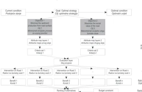
Fig. 1 General layout of the analysis
The present study combines GIS tools and AHP techniques to rank the maintenance priorities in a for -est road network. In particular, the proposed method -ology integrates the evaluation of the risk of erosion from road surface and the evaluation of the multi-functionality of forest roads, resulting particularly suitable for areas where the management of the roads have to consider many different functions. The result of the analysis is applied to support the use of the eco -nomic resources for the maintenance of a forest road network in the Italian Alpine region.
2. Material and methods – Materijal
i metode
2.1 Analysis structure – Struktura analize
Any decision-making process begins with the recog-nition of decision problems. A spatial decision problem is the difference between the desired and the existing state of a real-world geographical system (Mal czew ski 1999). Simon (1960) suggests that any decision-making process can be structured in three major phases: intel -ligence (is there a problem or an opportunity for change?), design (what are the alternatives?), choice
(which alternative is better?). The procedure passes through the evaluation of the actual status of a forest road network and the actual maintenance strategies to search for the improving elements (Fig. 1). The pro -duction of sediment from the gravel road surfaces represents one of the most frequent and hazardous processes directly connected with the presence and maintenance of the forest road network. The minimi -zation of this process is directly related to the correct execution of the maintenance interventions and has been considered as the first objective. The other lead -ing elements in determin-ing maintenance interven -tions are the type and level of use of the forest road. Following a multi-functional approach, the maximiza -tion of the social values has been considered as second objective in the priorities definition.
The set of criteria and the hierarchical structure of the decision problem have been developed through the examination of the relevant literature regarding the analyzed aspect and through the opinion of ex -perts and stakeholders.
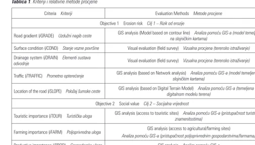
2.2 Criteria evaluation – Kriteriji procjene
Minimization of the risk of sediment production from forest road surface (Objective 1): sediment can be
Table 1 Considered criteria and relative evaluation methods
Tablica 1. Kriteriji i relativne metode procjene
Criteria – Kriteriji Evaluation Methods – Metode procjene
Objective 1 – Erosion risk – Cilj 1 – Rizik od erozije
Road gradient (iGRADE) – Uzdužni nagib ceste GIS analysis (Model based on contour line) – na slojničkim kartama)Analiza pomoću GIS-a (model temeljen
Surface condition (iCOND) – Stanje vozne površine Visual evaluation (field survey) – Vizualna procjena (terensko istraživanje)
Drainage system (iDRAIN) – Elementi sustava
odvodnje Visual evaluation (field survey) – Vizualna procjena (terensko istraživanje)
Traffic (iTRAFFIC) – Prometno opterećenje GIS analysis (based on Network analysis) – slojničkim kartama)Analiza pomoću GIS-a (model temeljen na
Location of the road (iSLOPE) – Položaj šumske ceste GIS analysis (based on Digital Terrain Model) – digitalnom modelu terena)Analiza pomoću GIS-a (temeljena na
Objective 2 – Social value – Cilj 2 – Socijalna vrijednost
Touristic importance (iTOUR) – Turistička uloga GIS analysis (access to touristic sites) – znamenitostima)Analiza pomoću GIS-a (pristupačnost turističkim
Farming importance (iFARM) – Poljoprivredna uloga GIS analysis (access to agricultural/farming sites)
Analiza pomoću GIS-a (pristupačnost poljoprivrednim gospodarstvima/farmama)
Productive importance (iPROD) – Gospodarska uloga GIS analysis – Analiza pomoću GIS-a
eroded from all road features but road surface erosion is generally the dominant source of sediment (Ramos-Scharron and MacDonald 2005). A recent review paper on surface erosion and sediment delivery model for unsealed road (Fu et al. 2010) effectively describes the main factors highlighted in literature. These factors include rainfall intensity and duration, snowfall, char-acteristic of road surface and used materials, road slo pe, traffic, construction standards and level of main te nan ce (MacDonald and Coe 2008). The gradient, or slope, of a road segment influences the erosion rate. Water flows down steeper road segments more quickly, resulting in a greater erosive power and in a higher shear stress (Bilby et al. 1989; Elliot and Tysdal 1999; Luce and Black 1999a). The width of the road and the extent of traffic on a road both influence the amount of erosion pro -duced from the road surface. Researches by Reid and Dunne (1984); Grayson et al. (1993); Luce and Black (1999b); Ziegler et al. (2001a); Sheridan and Noske (2007) were specifically aimed at determining the effects of traffic on road erosion. All of these studies showed increasing erosion rates with increased traffic use. Ac -cording to the literature, the set of criteria considered for Objective 1 are: road gradient, surface condition, presence of drainage structure, level of traffic and loca -tion of the road on the hill-slope (Table 1).
Maximization of the social value of the road net -work (Objective 2): to evaluate the social value, the different functions that each road can perform have been considered. After discussion with stakeholders of the studied area, we considered the following func-tions: touristic importance (access to important tourist sites), farming importance (access to farming activi -ties), productive importance (access to productive for -ests) and operative class (actual constructive param -eters of the road and ease of transit) (Table 1). Once the hierarchical structure of objectives and attributes has been established, each criterion can be represented as a raster map layer in the GIS database. Information about surface condition, presence of drainage struc -tures, operative class, touristic and farming impor -tance, were collected during the field surveys and re -ported as attributes to the layer representing the forest road network. To determine road gradient, hill-slope and level of traffic in a representative layer, three semi-automated analysis procedures have been developed using geo-processing tool for surface analysis and Net -work Analysis techniques. The analyses have been supported by ArcGIS 10 (ESRI 2011) and ModelBuild -er int-erface. In all the cases, the inputs needed to run the models are the digital terrain model (DTM) and forest type regional map.
Multi-criteria decision analysis requires that the values contained in the various criterion map layers
be transformable to comparable units. For this reason all of the data have been converted into standardized values using the maximum score procedures.
X X X ' ij ij = max (1) Where: X’
ij the standardized score for the ith object (alterna -tive),
jth attribute and x
ij is the raw score and xmax is the maximum score for the jth attribute.
The scale of standardized scores range from 0 to 1000, where higher overall score values indicate greater benefit. A pairwise comparison matrix was completed according to expert judgment and opinions of different people representing local perceptions regarding the importance of the different criteria. The following AHP analysis was supported by the use of a specific applica -tion (AHP 1.1 – Decision support tools for ArcGIS) for multi-criteria analysis based on pairwise comparison (Marinoni 2004a; Marinoni 2004b).
2.3 Evaluation of road conditions and
maintenance costs – Procjena stanja i troškovi održavanja šumskih cesta
The basis for the development of a road mainte -nance plan is a thorough understanding of the road system, its characteristics, and its needs. This is ac -complished by establishing and maintaining an inten -sive inventory of the road system. The inventory has to provide the information necessary for identifying and prioritizing the required maintenance such as cat -egorization of roads, identification of drainage struc -tures and their state and information related to the condition of the road surface (Cavalli et al. 2010).
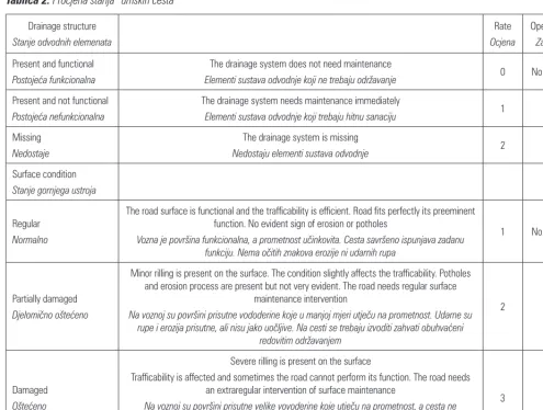
The most important characteristics of each forest road have been collected and organized in a geodata -base structure. Road survey information included road width, surface type, surface condition, traffic limitation, presence and efficiency of drainage struc -tures, functional and operative classification. To esti -mate the maintenance needs, the drainage system and surface condition were visually evaluated and rated as reported in Table 2.
The cross-drain culvert spacing (CS) is calculated in relation to the road gradient (slope, in %) using the following formula reported in the forest road manual (Oregon Department of Forestry 2000):
CS = 800/slope (2)
each road segment, where drainage structures are miss ing. The result has to be considered only as an in dication of how detailed placement of cross-drain -age culverts has to be evaluated taking into account the specific conditions of individual sites. The evalua -tion of maintenance needs is conducted to understand the current state of the forest road network and the gap between the actual and optimal conditions that repre -sents the area in which the definition of the best main -tenance strategy will be defined.
The result of the survey is a map representing all the maintenance operations needed to upgrade the forest road network. The sum of the maintenance interven -tions on each road section (node to node) represents one possible alternative in the ranking procedures.
Finally four types of possible maintenance opera -tions were defined. The mean cost for each type of ope-ration was determined through project analysis (Table
3) and the derived mean cost has been used to calculate the economic resources needed to complete each inter -vention (alternatives) on the forest road network.
3. Results – Rezultati
The methodology was applied to a test area of 3991 ha located in the »Altopiano dei Sette Comuni« in the North-Eastern part of Italy (latitude N of 45.56–45.52 longitude E of 11.23–11.28). The region is mainly cov -ered by Norway Spruce (Picea abies) and Beech (Fagus sylvatica) forests. The area represents a meaningful case study because the forest road network has to solve many different preeminent functions.
The recreational function is primarily a conse -quence of the presence of many historical sites related to the First World War and scenic hiking trails in the area. The silvicultural function is also important as
Table 2 Adopted code in the evaluation of the road conditions
Tablica 2. Procjena stanja šumskih cesta
Drainage structure
Stanje odvodnih elemenata
Rate Ocjena
Operation
Zahvat
Present and functional
Postojeća funkcionalna
The drainage system does not need maintenance
Elementi sustava odvodnje koji ne trebaju održavanje 0 No – Bez
Present and not functional
Postojeća nefunkcionalna
The drainage system needs maintenance immediately
Elementi sustava odvodnje koji trebaju hitnu sanaciju 1 A
Missing Nedostaje
The drainage system is missing
Nedostaju elementi sustava odvodnje 2 D
Surface condition
Stanje gornjega ustroja
Regular
Normalno
The road surface is functional and the trafficability is efficient. Road fits perfectly its preeminent function. No evident sign of erosion or potholes
Vozna je površina funkcionalna, a prometnost učinkovita. Cesta savršeno ispunjava zadanu funkciju. Nema očitih znakova erozije ni udarnih rupa
1 No – Bez
Partially damaged
Djelomično oštećeno
Minor rilling is present on the surface. The condition slightly affects the trafficability. Potholes and erosion process are present but not very evident. The road needs regular surface
maintenance intervention
Na voznoj su površini prisutne vododerine koje u manjoj mjeri utječu na prometnost. Udarne su rupe i erozija prisutne, ali nisu jako uočljive. Na cesti se trebaju izvoditi zahvati obuhvaćeni
redovitim održavanjem
2 B
Damaged
Oštećeno
Severe rilling is present on the surface
Trafficability is affected and sometimes the road cannot perform its function. The road needs an extraregular intervention of surface maintenance
Na voznoj su površini prisutne velike vovoderine koje utječu na prometnost, a cesta ne ispunjavaju svoju funkciju u potpunosti
Na cesti se trebaju izvoditi zahvati obuhvaćeni periodičnim održavanjem
expected due to the presence of productive forest. Fi -nally, the forest road network has to guarantee access for the farming activities. The length of the primary forest road network inside the area is 107.8 km (of which 80 km are gravel roads) with a density of 26 m/ha. Lastly, 68.1 km (65.4%) of the road network is acces -sible without restriction (public roads) while 39.7 (34.6%) presents restrictions.
3.1 Definition of alternatives and maintenance
cost analysis – Određivanje varijanti i troškovna analiza održavanja
The field survey shows that 12% of the total exten -sion of the forest road network is in good conditions,
while the remaining 88% requires maintenance inter -ventions. 390 maintenance interventions have been iden tified among a total of 44 road segments (alternati-ves). The majority of maintenance operations involve the improvement of the drainage system, including the installation of new structures (53% of the total exten -sion) and cleaning of the existing ones (23%). Surface maintenance is required on 11 road segments (20%).
The total investment to complete the maintenance of the project was estimated to 68 297 €. Table 4 shows the number of needed interventions and the estimated budget to complete all the interventions. During the observed period, 2008–2010, the management author -ities carried out interventions on 27 forest roads with
-Table 3 Types of road maintenance operations performed and related costs
Tablica 3. Vrste i relativni troškovi izvođenih radova pri održavanju šumskih cesta
Operation type Vrsta radova
Operational details
Detalji pri izvođenju pojedine vrste radova
Cost Trošak
A, Drainage structure cleaning
A, čišćenje elemenata odvodnje
2 operators
2 radnika 1.10 € DS
–1*
B, Regular surface management**: addition of crushed aggregate and consolidation
B, redovito održavanje**: dovoz rasutoga materijala i ugradnja
1 Tractor with grader – Traktor s grejderskom daskom
1 Truck for gravel transportation – Kamion za transport šljunka
3 operators – 3 radnika
1.21 € m–1
C, Extraordinary surface management**
C, periodično održavanje**
1 Tractor with grader – Traktor s grejderskom daskom
1 Truck for gravel transportation – Kamion za transport šljunka
Excavator – Bager
3 operators – 3 radnika
6.32 € m–1
D, Drainage structure installation
D, Ugradnja odvodnih elemenata
Excavator – Bager
2 operators – 2 radnika Materials – Materijal
52 € DS–1*
* DS: drainage structure (standard length 5 m) – *DS: odvodni elementi (standardna duljina 5 m)
** standard road width 3.50 m – **Standardna širina ceste 3,50 m
Table 4 Required maintenance interventions and estimated costs
Tablica 4. Potrebni radovi pri održavanju i procijenjeni troškovi
Operation type – Vrsta radova Interventions, n
Učestalost izvođenja pojedine vrste radova, n
Total cost, €
Ukupni troškovi, €
A (Drainage structure cleaning) – A (Čišćenje elemenata sustava odvodnje) 98 107.8 B (Regular surface management) – B (Redovito održavanje) 6 10 350
C (Extraordinary surface management) – C (Periodično održavanje) 5 34 617 D (Drainage structure installation) – D (Ugradnja odvodnih elemenata) 281 14 612
in the area for a total of 30.7 km of roads maintained, with the total expense of 87 000 €. According to this, the assumed annual budget for regular maintenance equals 29 000 € (budget constraint).
3.2 Rating and ranking of alternatives
Ocjenjivanje i vrednovanje varijanti
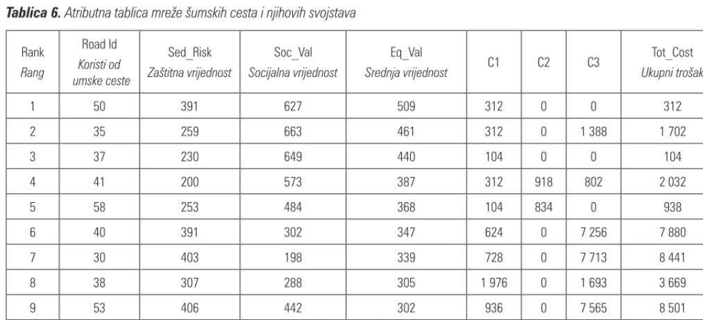
Table 5 shows the output weights for the different factors taken into consideration, after the AHP pair -wise grid evaluation.
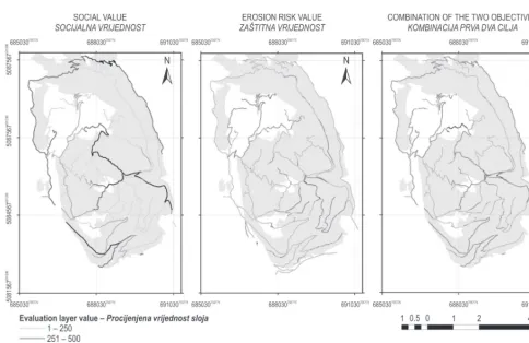
Application of the spatial AHP analysis led to the creation of the two raster layers that represent the ben
-efit score referred to the relative objective for each cell of the road surface. The combination of the two layers at the highest level of the AHP analysis, produced the final evaluation layer that represented the overall ben -efit score for each cell. The evaluation layer maps made as a result of the application of the AHP process are presented in Fig. 2.
Through the use of a zonal statistic tool, the cell values on the evaluation layer were summarized with -in the forest road network features and the statistics relative to the benefit value of each road have been calculated. Table 6 is an example of the attribute table
Table 5 Criteria weights as resulted from pairwise grid evaluation
Tablica 5. Procjena kriterija udvojenoga vrednovanja
Objective 1 – Erosion risk – Cilj 1 – Rizik od erozije Objective 2 – Social value – Cilj 2 – Socijalna vrijednost
Sub-criteria – Potkriterij Weight – Težina Sub-criteria – Potkriterij Weight – Težina
iGRADE 0.5661 iTOUR 0.4236
IDRAIN 0.2012 iOPER 0.2903
ICOND 0.1319 iFARM 0.1745
iSLOPE 0.1007 iPROD 0.1114
Consistency ratio* (CR): 0.0434
Faktor dosljednosti* (CR): 0,0434
Consistency ratio* (CR): 0.0750
Faktor dosljednosti* (CR): 0,0750
*Revision of preference values is recommended if CR > 0.1
*Preporučuje se preispitivanje vrijednosti ako je CR > 0,1
Table 6 Attribute tables of the features of forest road network
Tablica 6. Atributna tablica mreže šumskih cesta i njihovih svojstava
Rank
Rang
Road Id Koristi od šumske ceste
Sed_Risk
Zaštitna vrijednost
Soc_Val
Socijalna vrijednost
Eq_Val
Srednja vrijednost C1 C2 C3
Tot_Cost
Ukupni trošak
1 50 391 627 509 312 0 0 312
2 35 259 663 461 312 0 1 388 1 702
3 37 230 649 440 104 0 0 104
4 41 200 573 387 312 918 802 2 032
5 58 253 484 368 104 834 0 938
6 40 391 302 347 624 0 7 256 7 880
7 30 403 198 339 728 0 7 713 8 441
8 38 307 288 305 1 976 0 1 693 3 669
9 53 406 442 302 936 0 7 565 8 501
10 28 309 259 298 104 0 0 104
of the features of forest road network after the applica -tion of the AHP analysis. Roads (ROAD ID) are ranked according to their benefit value, where SED_RISK rep -resents the risk value of sediment production from the road surface, SOC_VAL represents the social value of the road and EQ_VAL represents the combination of the two values (evaluation layer). C1, C2 and C3 rep -resent the costs of different maintenance operations, while TOT_COST represents the total cost to upgrade the road.
3.3 Definition of the optimal maintenance
strategies – Utvrđivanje optimalnih strategija održavanja
Information contained in the AHP output table (Table 6) can be used to rank the maintenance needs and thus define the priority intervention that should be funded in order to have the highest benefit. For example roads that present a higher erosion risk re -quire more efforts to be maintained in good condition; on the other hand, according to the importance of the territory accessibility, roads with higher social value should be preferably maintained in good conditions.
Fig. 3 shows the mapping of the forest road net -work highlighting the parts that will be maintained with the budget of 29 000 € for regular maintenance, in accordance with different objectives. When only the social value of the roads is considered, the mainte -nance operations will regard a road extension of 40 km of which 31 km (77%) are actually open to traffic. Con -sidering only the minimization of the erosion, the maintenance operations will regard 8.5 km of which 4.2 km (49%) are open to traffic. In this case, mainte -nance is concentrated on few roads that are evaluated as more problematic because the condition of the road is critical and maintenance interventions are more ex -pensive.
Finally, considering the combination of the two ob -jectives, the maintenance operations will regard an extension of 29 km of which 25.5 km (89%) are open to traffic.
Evaluating the correspondence between the pri -orities resulting from the AHP analysis and the actual maintenance strategies, the highest correspondence (65%) is reached with equal consideration of the two objectives, where 18.8 km of the road considered a pri
-Fig. 2 Maps representing the evaluation layers considering different objectives
ority had maintenance intervention in the last three years. In contrast, the consideration of the erosion risk has the lowest correspondence (25%) with 2.2 km that have been maintained. Finally, when the priorities de -fined considered only the social value, a correspon -dence of 56% was found, with 22.7 km that have been maintained.
4. Discussion and conclusion – Zaključci
s raspravom
The economic resources necessary to completely upgrade the forest road network are equal to 67 000 €. Additionally, the yearly regular maintenance cost is 29 000 €. These values highlight the inadequacy of the
Fig. 3 Maps representing the optimal feasible maintenance strategies considering different objectives
Slika 3. Karte predstavljaju optimalne strategije održavanja s obzirom na različite ciljeve
Table 7 Description of maintenance strategies considering different objectives
Tablica 7. Opis strategija održavanja s obzirom na različite ciljeve
Total interventions
Ukupno zahvata
Interventions on public roads
Zahvati na javnim cestama
Correspondence with actual management
Podudaranje sa stvarnim upravljanjem
km km %
Considering social value – S obzirom na socijalnu vrijednost 40 31 56
Considering erosion risk – S obzirom na rizik od erozije 8.5 4.2 25
current annual budget to meet the maintenance re -quirements of a forest road network in the considered mountainous area. The lack of economic resources af -fects the »modus operandi« of the management au -thority that constantly has to choose which roads to keep in good condition. The current strategy guaran -tees constant maintenance mainly on the roads open to traffic, where road standards and level of traffic need to be higher.
Field surveys suggest that the management strat -egy should be reconsidered. Erosion and consequent production of sediment from the gravel road surface is a frequent process, directly connected with the worsening of the road conditions. In particular, the general lack of drainage structures seems to be one of the most important factors leading to a consistent de -livery of sediment from forest road surface. Due to this situation, the opportunities for structural improve -ment of the manage-ment strategies have been evalu -ated.
In this context the integrated use of GIS tools and AHP analysis proved to be a valuable tool to better understand the ongoing processes and to give guide -lines for determining the maintenance operations. The proposed methodology integrates two different as -pects through the pairwise comparison process; the evaluation of the erosion risk and the evaluation of the social value of the roads considering a total of eight criteria. Additionally, the model can be adapted to the preferences of the stakeholders, who can specify which function of the forest road network should be considered preeminent for the specific vocation and needs of the analyzed area.
The resulting evaluation layer has been used to un -derstand the benefits of the required maintenance op -erations and to define the priorities. The distribution of the priorities considering the combination of the two objectives justifies the maintenance strategy cur -rently practiced, as it indicates that the available bud -get (29 000 €) is in large part (89%) allocated to the maintenance interventions on the public roads, and that 65% of the resources involve roads that have been recently maintained. On the other hand, the risk of erosion seems to be considered minor because only 25% of the roads with high risk of erosion have been recently maintained.
In conclusion, the use of integrated GIS tools and AHP analysis shows that different aspects can be ef -fectively integrated. Consequently, this approach could be used to improve the efficiency of administra -tion and management of maintenance planning, espe -cially considering that the existing forest road system needs to evolve toward a paradigm where other ben
-efits (e.g. recreational value) and priorities (e.g. envi -ronmental aspects) are included. Methods for the con -sideration of these objectives should be developed.
Acknowledgement – Zahvala
This study has been developed within the Test site Asiago of the NEWFOR project financed by the Euro -pean Territorial Cooperation »Alpine Space« (5-3-2-FRA).
5. References –
Literatura
Abdi, E., Majnounian, B., Darvishsefat, A., Mashayekhi, Z., Sessions, J., 2009: A GIS-MCE based model for forest road planning. Journal of Forest Science 55 (4): 171–176.
Bilby, R. E., 1985: Contributions of road surface sediment to a western Washington stream. Forest Science 31(4): 827–838. Cavalli, R., Grigolato, S., 2010: Influence of characteristics and extension of a forest road network on the supply cost of forest woodchips. Journal of Forest Research 15(3): 202–209. Cavalli, R., Cappellari, E., Grigolato, S., 2010: Metodologia per la valutazione delle esigenze di viabilità silvo-pastorale in un contesto montano (Method for assessment of forest road network requirement in a mountain area). L’Italia Fore
-stale e Montana 65(3): 313–330.
Coulter, E. D., Sessions, J., Wing, M. G., 2006: Scheduling forest road maintenance using the analytic hierarchy process and heuristics. Silva Fennica 40(1): 143–160.
Dubè, K., Megahan, W., Mccalmon, M., 2004: Washington
Road Surface Erosion Model (WARSEM) Manual. Depart
-ment of Natural Resources, State of Washington, 189 p. Elliot, W. J., Tysdal, L. M., 1999: Understanding and reducing erosion from insloping roads. Journal of Forestry 97(8): 30– 34.
ESRI, 2011. ArcGIS 10. Redland, CA: Environmental System Research Institute. <http://webhelp.esri.com> (Accessed 28 Febbruary 2012).
Feng, Zhen-Wei, Douglas, R. A., 1993: Logging truck vehicle performance prediction for efficient resource transportation system planning: Computer Modelling Approach. Journal of Forest Engineering 4(2): 7–18.
Fu, B., Lachlan, T. H., Newham, L. T. H., Ramos-Scharron, C. E., 2010: A review of surface erosion and sediment deliv
-ery models for unsealed roads. Environmental Modelling and Software 25 (1): 1–14.
Grayson, R. B., Haydon, S. R., Jayasuriya, M. D. A., Finlay
-son, B. L., 1993: Water quality in mountain ash forests – sep
-arating the impacts of roads from those of logging opera
-tions. Journal of Hydrology 150(2–4): 459–480.
-plex Approach. Croatian Journal of Forest Engineering 31(2): 127–135.
Luce, C. H., Black, T. A., 1999a: Sediment Production from Forest Roads in Western Oregon. Water Resources Research 35(8): 2561–2570.
Luce, C. H., Black, T. A., 1999b: Changes in erosion from gravel surfaced forest roads through time. In Proceedings of the International Mountain Logging and 10th Pacific North
-west Skyline Symposium. International Union of Forestry Research Organizations and Oregon State University, Cor
-vallis, Oregon, p. 204–218.
MacDonald, L. H., Coe, D. B. R., 2008: Road sediment pro
-duction and delivery: processes and management. In: Pro
-ceedings of the First World Landslide Forum, International Programme on Landslides and International Strategy for Disaster Reduction. United Nations University, Tokyo, Ja
-pan, p. 381–384.
Malczewski, J., 1999: GIS and Multicriteria Decision Analy
-sis. New York: John Wiley.
Marinoni, O., 2004a: Implementation of the analytical hier
-archy process with VBA in ArcGIS. Computers and Geo
-sciences 30(6): 637–646.
Marinoni, O., 2004b: Some words on the analytic hierarchy process and the provided ArcGIS extension ext_ahp. <http:// arcscripts.esri.com/details.asp?dbid=13764> (Accessed 28 Febbruary 2012).
Oregon Department of Forestry, 2000: State Forest Program – Forest Road Manual. <http://www.oregon.gov/ODF/ STATE_FORESTS/roadsmanual.shtml> (Accessed 28 Febru
-ary 2012).
Potočnik, I., 2006: Road traffic in Protected Forest Areas – Case Study in Triglav National Park, Slovenia. Croatian Jour
-nal of Forest Engineering 27(2): 116–121.
Ramos-Scharron, C. E., MacDonald, L. H., 2005: Measure
-ment and prediction of sedi-ment production from unpaved
roads, St John, US Virgin Islands. Earth Surface Processes and Landforms 30(10): 1283–1304.
Reid, L. M., Dunne, T., 1984: Sediment production from for
-est road surfaces. Water Resources Research 20(11): 1753– 1761.
Saaty, T. L., 1980: The Analytic Hierarchy Process: Planning, Priority Setting, Resource Allocation. McGraw-Hill, New York.
Schmoldt, D. L., Kangas, J., Mendoza, G. A., Pesonen, M., 2001: The Analytic Hierarchy Process in Natural Resource and Environmental Decision Making. Dordrecht, The Neth
-erlands: Kluwer Academic Publishers.
Sheridan, G. J., Noske, P. J., 2007: A quantitative study of sediment delivery and stream pollution from different forest road types. Hydrological Processes 21(3): 387–398.
Shiba, M., 1995: Analytic hierarchy process (AHP) based multi attribute benefit structure analysis of road network system in mountainous rural areas of Japan. International Journal of Forest Engineering 7(1): 14–50.
Simon, H. A., 1960: The new science of management deci
-sion. New York: Harper and Row.
Talbot, B., Nitteberg, M., 2011. Using transloading times in determining the effect of reduced road standards on the de
-livered cost of timber. In: Pushing the boundaries with re
-search and innovation in forest engineering. FORMEC 2011 Proceedings. Graz, October 9–13.
Thompson, M., Sessions, J., Boston, K., Skaugset, A., Tomber
-lin, D., 2010: Forest Road Erosion Control Using Multiobjec
-tive Optimization. Journal of the American Water Resources Association 46(4): 712–723.
Ziegler, A. D., Sutherland R. A., Giambelluca, T. W., 2001: Interstorm surface preparation and sediment detachment by vehicle traffic on unpaved mountain roads. Earth Surface Process and Landforms 26(3): 235–250.
Sažetak
Određivanje prioriteta pri održavanju šumskih cesta pomoću višekriterijskih
modela odlučivanja: primjena u alpskom području u Italiji
U ovom radu kombinacijom GIS-a i analitičkoga hijerarhijskoga procesa (AHP) razvijen je sustav potpore pri odlučivanju (DSS) i vrednovanju prioriteta u održavanju mreže šumskih cesta.
U procesu donošenja odluka čini se da AHP ima mogućnost unaprijediti upravljanje postojećim prometnim sustavima gdje još u potpunosti nisu određeni mjerljivi odnosi između uzroka i posljedica oštećenja.
Predložena metodologija integrira procjenu rizika od erozije s vozne površine šumske ceste uz određivanje mul -tifunkcionalnosti šumskih cesta, što se pokazalo posebno pogodnim za područja gdje se pri upravljanju šumskim cestama moraju uzeti u obzir mnoge različite funkcije koje promatrana šumska cesta obnaša.
analize te su definirane metode procjene. Skup kriterija i hijerarhijska struktura DSS-a razvijeni su istraživanjem relevantne literature i analiziranjem mišljenja stručnjaka i ostalih interesnih skupina. Kriteriji koji su korišteni pri procjeni erozijskih procesa su: uzdužni nagib ceste, stanje gornjega ustroja, stanje sustava (elemenata) odvodnje, učestalost prometa (prometno opterećenje), položaj šumske ceste s obzirom na poprečni nagib. Kriteriji korišteni pri procjeni socijalne vrijednosti šumskih cesta su: turističko značenje (pristupačnost turističkim znamenitostima), kategorija šumske ceste, poljoprivredno značenje (pristupačnost poljoprivrednim gospodarstvima/farmama) i gospo -darska važnost (pristup šumskoj površini).
U trećoj je fazi primijenjena analiza AHP-a, uz uporabu specijalne aplikacije u GIS-u, pri izračunu (ocjeni) po -jedinih slojeva koji predstavljaju važnost svake ceste s obzirom na zadane ciljeve. Vrijednost po-jedinih slojeva korištena je u četvrtoj fazi pri rangiranju zahvata u održavanju šumskih cesta.
Navedena metodologija testirana je na mreži primarnih šumskih prometnica u alpskom području u Italiji ukupne duljine od 107,80 km.
Na terenu su prikupljeni podaci o najvažnijim obilježjima pojedine šumske ceste. Terenska je izmjera uključivala širinu šumske ceste, tip gornjega ustroja, stanje vozne površine, prometna ograničenja, pojavnost i učinkovitost el -emenata sustava odvodnje, funkcionalnu i operativnu raščlambu. Potreba za održavanjem el-emenata sustava odvod -nje i sta-nje vozne površine procjenjivana je vizualno.
Definirane su četiri vrste radnih operacija pri održavanju šumskih cesta te su projektnom analizom ustanovljeni prosječni jedinični troškovi svake radne operacije. Stvarni je proračunski limit određen kao iznos sredstava koja se najčešće utroše pri održavanju šumskih cesta.
Rezulat je analize niz karata na kojima su prikazani prioriteti održavanja za svaku istraživanu šumsku cestu. Usporedba navedenih rezultata sa stvarnim stanjem šumskih cesta na terenu pokazala je da je integrirana upotreba GIS-a i AHP-a vrijedan alat pri vrednovanju gospodarske važnosti pojedine šumske ceste i pri definiranju prioriteta u održavanju mreže primarnih šumskih prometnica radi povećanja ukupnih koristi uz minimalni utrošak novčanih sredstava.
Prikazana se metoda može primijeniti za poboljšanje učinkovitosti pri upravljanju i planiranju održavanja šumskih cesta, uzmajući u obzir činjenicu da se postojeća mreža šumskih cesta mora razvijati prema pretpostavci da su ostale koristi (npr. rekreativna vrijednost) i prioriteti (npr. ekološke značajke) uključeni.
Ključne riječi: održavanje šumskih cesta, troškovi održavanja, AHP, GIS, DSS
Received (Primljeno): April 17, 2012 Accepted (Prihvaćeno): December 10, 2012
Authors’ address – Adresa autorâ: Marco Pellegrini, PhD.*
e-mail: [email protected] Stefano Grigolato, PhD.
e-mail: [email protected] Prof. Raffaele Cavalli, PhD. e-mail: [email protected] University of Padua
Department of Land, Environment, Agriculture and Forestry
Viale dell’Università 16 35020 Legnaro (PD) ITALY