World Maritime University
World Maritime University
The Maritime Commons: Digital Repository of the World Maritime
The Maritime Commons: Digital Repository of the World Maritime
University
University
World Maritime University Dissertations
Dissertations
1996
Policy and management proposal for sustainable development of
Policy and management proposal for sustainable development of
coastal areas of Cambodia : Sihanoukville as a case study
coastal areas of Cambodia : Sihanoukville as a case study
Vann Monyneath
WMU
Follow this and additional works at:
https://commons.wmu.se/all_dissertations
Part of the
Transportation Commons
Recommended Citation
Recommended Citation
Monyneath, Vann, "Policy and management proposal for sustainable development of coastal areas of
Cambodia : Sihanoukville as a case study" (1996). World Maritime University Dissertations. 917.
https://commons.wmu.se/all_dissertations/917
This Dissertation is brought to you courtesy of Maritime Commons. Open Access items may be downloaded for
non-commercial, fair use academic purposes. No items may be hosted on another server or web site without express
WORLD MARITIME UNIVERSITY Malmo, Sweden
POLICY AND MANAGEMENT PROPOSAL FOR
SUSTAINABLE DEVELOPMENT OF COASTAL
AREAS OF CAMBODIA--SIHANOUKVILLE AS A
CASE STUDY
By
VANN MONYNEATH
Kingdom of Cambodia
A dissertation submitted to the World Maritime University in partial fulfilment of the requirement for the award of the decree of
MASTER OF SCIENCE
in
GENERAL MARITIME ADMINISTRATION
ENVIRONMENT PROTECTION
1996
DECLARATION
I certify that all the material in this dissertation that is not my own work has been identified, and that no material is included for which a decree has previously been
conferred on me.
The contents of this dissertation reflect my own personal views, and are not necessarily endorsed by the University.
(Signature)
...
(Date)
,/
Supervised
by.
7/C‘/)y/,,‘/)7
)
ProfessorT. J. Sampson /
Course Professor
General Maritime Administration and Enviromnent Protection World Maritime University
/
Assessed by:
Professor Hugh R. Williamson Visiting Professor
6188 Pepperell Street, Halifax, Nova Scotia CANADA B3H 2N9
Co-assessed by:
Dr. Jean Snider
Director of Program Development for HAZMAT National Ocean Service
ACKNOWLEDGEMENT
I dedicated this work to my parents Mr. and Mrs. Vann Sithun; my wife
Beng Parikhar and son Vann Yuvakteip. You are all the Light in My life.
My greatest thanks to :
His Majesty the King of the Kingdom of Cambodia, Preah Bat Samdeach
Norodom Sihanouk Varaman; the first Prime Minister Samdeach Krom Preah
Norodom Naranariddh; the second Prime Minister Samdeach Hun Sen; His
Excellency the Minister of Environment, Dr. Mok Mareth who gave me this
opportunity to attend this course.
My sincerest appropriation to my sponsor the Carl Duisberg Gesellschafi
CDG (Germany) which provided the fellowship for me to attend this course. Special
thinks also to Ms. Birgitt Ory Prime secretary of Germany Embassy in Cambodia and
her colleagues for their best support and for their assistance to me in helping to get
this scholarship.
I am very much indebted to the resident and visiting professors for their
uncountable and meaningful lectures. Particularly Professor T. J. Sampson my
course professor and T. Callahan who were both very helpful and wonderfiil in
giving their priceless advice, guidelines and support throughout the duration of my
studies and preparation of this dissertation. I would very much thinks to my assessor
Professor Hugh R. Williamson for his suggestions and advice.
Special thanks go to all academic staff of World Maritime University for their
help and assistance in many ways during my study at this university. Particularly I
extend a big thanks to English Language Lecturer Clive Cole who has tried his best
I would like to express my gratitude to Mr. Sen Saroeun, Cabinet chief of the MoE; Mr. Kanthien Koy Programme Officer, UNDP-Carnbodia; Mr. Ly Kim Chhun,
Sihanoukville Port director; Mr. Sum Sannisith, Director General Planning of the
Department, (MoP); Mr. Ruos Sam Ear, Deputy Director of the Planning Department
(MoT); Mr. I-Io Vichet, Director Planning of the Department (MIME); and to Mr.
Hun Phea, Secretary of Sihanoukville Sub-CLMU, for their support and assistance
throughout the period of my field research in the Kingdom of Cambodia.
Many thinks are also due to Mr. Paul D. Moen NOAA-Manager Upper Keys
Region, Florida Keys National Marine Sanctuary; Mr. Charles D. Beeker Director
Underwater Science and Educational Resources, Indiana University; Mr. Leo
Francendese, Federal Scenic Co-ordinator, USEPA Region IV; Capt Larry L. Hereth,
Commanding Officer US Coast Quard National Strike Force, all who took time and
effort to assist me to get valuable information and materials during my field hip to
United States.
Very much thinks are to Mr. Andrew Brabury Coastal Engineer; and Mr. Mel
Watkins, Coastal Projects Offier, Hampshire County Council, Marine Protective
Area, for their excellent explanation and materials provided during the field studies
in the United Kingdom.
I wish to think Persons in charge of Port of Tallin and Estonian Marine
Tourism Association for the assistance provided during field studies in Estonia
And last but not least, special gratitude is extended to my heartfelt parent-in
law Mr. and Mrs. Beng Siphon, elder brother and wives Mr. and Mrs. Long Sophea,
Mr. and Mrs. Kung Sanmang, Mr and Mrs. Unn Navarm, Mr. and Mrs. Sok Sareth,
Mr. and Mrs. Varm Moniroth, who have always been by my side and assisted me in
ABSTRACT
Title of Dissertation : Policy and Management Proposal for Sustainable
Development of Coastal Areas of Cambodia—Sihanoukvil|e
as a Case Study
Degree : Master of Science
The dissertation is a study of coastal resources policy and management
strategy for the development of the Sihanoukville Coastal Region which can be
followed and implemented. It consists of five chapters.
A brief look is taken at Carnbodia’s existing biophysical coastal enviromnent,
the significant coastal and socio-economic features, as well as coastal economic
activities of the Sihanoukville region.
Development and growth in the Sihanoukville coastal planning region in the
areas of tourism and recreation, sea-port expansion, residential, airport expansion,
construction and industrialisation, fishing, agriculture are investigated.
The integral environmental considerations concerning the coastal issues and
the potential impacts on a wide diversity of marine life from a newly planned coastal
developments are discussed. In addition, the conflicts between those activities are
identified and analysed.
Further, current policies, legislation, and institutions involved in the
Finally, proposals are made for coastal resources policy and strategy to
achieve sustainable development and management of coastal resources. A proposed
mechanism and structure responsible for an Integrated Management of Coastal and
Marine Environment is included as is the Sihanoulcville master plan in order to
ensure that the embedded threats to the environment from development of this
TABLE OF CONTENTS
Declaration
Acknowledgements
Abstract
Table of Contents
List of Tables
List of Figures
List of Abbreviations
Introduction
1 Cambodia's Coastal Environment and Use of Resources
1.1 Biophysical coastal environment
1.2 Significant coastal feature
1.2.1 Mangrove Forest 1.2.2 Estuaries 1.2.3 Coral Reefs 1.2.4 Seagrasses 1.2.5 Oil and Gas 1.3 Socio-ecomonic features
1.3.1 Population and Employment 1.3.2 Institution and Legislation 1.3.3. Economic Performance 1.4 Coastal ecomonic activities
1.4.1 Agriculture 1.4.2 Fisheries 1.4.3 Aquaculture
1.4.4 Mangrove Harvesting
1.4.5 Industry 1.4.6 Tourism
1.4.7 Ports and Shipping
The Coastal Sihanoukvllle Region
2.1 Sihanoulcville Region
2.1.1 Geographical description of Sihanoulcville
2.1.2 Climate
2.1.3 Population and Density
2.2 Human activities in coastal Sihanoulcville region 2.2.1 Agriculture
2.2.2 Fisheries 2.2.3 Industry 2.2.4 Sihanoukville Port 2.2.5 Tourism
2.2.6 Coastal Conservation and Protection 2.3 Socio-economic profile
2.4 Sihanoukville national planning development
2.4.1 General status
2.4.2 Description of plan 2.4.2.1 Port development zone 2.4.2.2 Industrial development zone 2.4.2.3 Tourism development zone
2.4.3 Rules for protection of Port, Industry, and Tourism zones 2.4.3.1 Port and Industrial zone
2.4.3.2 Tourism installations 2.5 Summary
Integrating Environmental Considerations into the Sihanoukville Coastal Development
3.1 The current coastal and marine enviromnental issues and causes 3.1.1 Fisheries issues
3.1.1.1 Overfishing
3.1.1.2 Use of harmful traditional methods 3.1.1.3 Ineffective enforcement of fisheries law 3.1.1.4 Data collection problems 3.1.2 Port issues
3.1.3 Mangrove forestry issues 3.1.4 Coastal habitat issues 3.1.5 Pollution issues
3.1.5.1 Transportation of oil 3.1.5.3 Urbanisation
3.2 The major impacts of new plans for coastal development 48
3.2.1 Consideration and Analysis of impacts of development port 48
3.2.1.1 Impact of port location 49
3.2.1.2 Impact of port construction 50
3.2.1.3 Sectors affected by these problems 51
3.2.2 Consideration and Analysis of impacts of tourism development 52
3.2.2.1 Impact on the coastal inland resources 5
3.2.2.2 Impact on the coastal water resources 54
3.2.3 Impacts of oil and gas industrial development and expansion 55
3.3 Summary 56
Policy, Legal and Institutional Framework for Sihanoukville Coastal Management
4.1 Current national policy 61
4.2 Laws and Decree/Sub decree related to coastal planning and 62
management
4.2.1 Law on Fisheries 62
4.2.2 Law on Forestry 63
4.2.3 Royal decree on the Creation and Designation of 63
Protection Areas
4.2.4 Law on Land Management, Urbanisation and Construction 63
4.2.5 Law on Investment 64
4.2.6 Sub-decree for the Zoning and Administration of Sihanoukville 64
4.3 International conventions 65
4.4 The main organisations involved in coastal planning development and 66 management in Sihanoukville
4.4.1 Ministries/agencies and their responsibility 66
4.5 Legislative, Organisational and Management issues 71
4.5.1 Legislation issues 71
4.5.2 Organisation and Management issues 73
4.5.2.1 The existing restructuring of the state 73
4.5.2.2 The existing co-ordination 73
4.6 Sununary 75
Recommendations for Policy and Management Strategy
5.1 An Integrated National Policy 77
5.1.1 Thleneed for an Integrated Coastal Resources ManagementP0 icy 78
5.2 Management Strategies 79 5.2.1 The need for Cambodian Coastal Management Act 79 5.2.2 The need for an Environmental Impact Assessment 80 5.2.3 The need for promoting Marine Protection Area(s) 81
5.2.4 The need for improving Marine Fisheries Management 82
5.2.5 ‘Theneed for Coastal Environmental Awareness, Education 83
and Training
5.2.6 The need for Regional and Intemational Co-operation 85
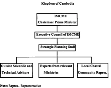
5.2.7 The need for Integrated Management of Coastal and 85
Marine Environment (IMCME) incorporating Strategic Planning
5.2.7.1 Objective of IMCME 85
5.2.7.2 Proposed National Body Responsible for an IMCME 86
5.2.7.3 IMCME Responsibilities 87
Conclusion 90
Bibliography 93
Appendices
Appendix 1 Royal decree on Creation and Designation of Protected Areas 97
Table 1 Table 2 Table 3 Table 4 Table 5 Table 6 Table 7
LIST OF TABLES
Rice production by year in the coastal provinces (T)
Population and growth rate in Sihanoukville 1980-1995
Estimated area of agriculture land 1985-1993
Land use for agriculture products in Sihanoukville
Fish production fiom 1988-1994
Fish capture exported from 1992-1994
Employment in Sihanoukville, 1995
Figure I Figure 2 Figure 3
Figure 4
Figure 5
Figure 6
Figure 7 Figure 8 Figure 9
LIST OF FIGURES
Administration map of Cambodia
The Major Rivers in the Coastal area of Cambodia
Map on Coral reefs and Sea grass beds
Map on Sihanoukville and Vicinity
Sihanoukville Master Plan, 1995
Conflicts between Human Activities
Impact Matrix of Conflicts in the Sihanoukville region
Proposed Organogram of the Ministry of Environment
Proposed Structure for Integrated Management of Coastal and
Marine Environment (IMCME) incorporating Strategic Planning
ADB API-IEDA AWB Cambodia CDC CFC DOF EIA FAO GDP GRT IDRC ILO IMCME IMDG IUCN LUMO MAFF MARPOL MEYS MoE MoEF MoND MoP MoRD MoT
LIST OF ABBREVIATIONS
Asian Development Bank
Australian People for Health and Education Abroad
Asian World Bank
Kingdom of Cambodia
Council on Development for Cambodia
Cambodia Fuel Company
Department of Fisheries
Environmental Impact Assessment
Food and Agriculture Organisation
Gross Domestic Product
Gross Registered Ton
International Development Research Centre
International Labour Organisation
Integrated Management of Coastal and Marine Environment
International Maritime Dangerous Goods
International Union for Conservation of Nature and Natural Resources
Land Use Mapping Office
Ministry of Agriculture, Forestry and Fisheries
International Convention for Prevention of Oil Pollution from Ship
Ministry of Education, Youth and Sports
Ministry of Industry, Mines and Energy
Minist:ryof Environment
Ministry of Economics and Finance
Ministry of National Defence
Ministry of Planning
Ministry of Rural Development
lvfl’WT
NCLMU
NGO
NPRD
OECD OPRC
PADCO
RGC SOLAS "Sub-CLMU
UNDP
UNEP
UNESCO
USEPA
UNICEF
USD
UNTAC
Ministry of Public Works and Transport
National Committee for Land Management and Urbanisation
Non-Govemmental Organisation
Natonal Programme for Rehabilitation and Development
Organisation for Economic Co-operation and Development
Oil Pollution Preparedness, Response and Cooperation
Planning and Development Collaboration
Royal Government of Cambodia
International Convention for Safety of Life at Sea
Sub-Committee for Land Management and Urbanisation
United Nations Development Programmes
United Nations Environmental Programmes
United Nations Educational, Scientific and Cultural Organisation
United States Environmental Protection Agency
United Nations Children's Fund
United States Dollar
INTRODUCTION
Many coastal waters of Southeast Asian countries have rich ecosystems
characterised by extensive coral reefs and dense mangrove forests. Endowed with
warm tropical weather and high rainfall, these waters are further enriched with
nutrients from the land which enable them to support a diversity of marine life.
Cambodia's Coastal Area, is one of these, and it is of great economic and
environmental significance. This significance is evident in the variety and types of
demands made on the coastal area and its resources. These demands consist of the
settlements at the coast, fishing, agriculture, infrastructure development, industrial
development, tourism and recreation, landscape, and wildlife, and habitat protection.
In particular, the Sihanoukville Coastal Region is of great importance as the
other coastal provinces are not subject to the same magnitude of demands by
increasing population and economic pressure. In Sihanoukville these demands are
manifested by a variety of coastal activities and newly planned activities that involve
fishing, port development, tourism development, construction and industrialisation.
This situation is aggravated by expanding economic planning developments
attempting to uplifi the standard of the living of the Kingdom of Cambodian people.
The government has formulated regulatory measures for management of the
coastal resources such as the issuance of permits for sea-ports, tourism, recreation,
fishing, and mangrove harvesting. However, most of such measures have not proven
effective impact due to enforcement failure but largely due to lack of support of the related communities.
Several coastal resources management issues continue to further complicate
arising fiom administration and legislation overlaps among different resource sectors
and between levels of government; the absence of sufficient data about coastal
resources and their wise utilisation and the limited range of instruments used to carry
out integrated coastal area management are also limiting factors.
Regarding the issues mentioned above, this dissertation concentrates on a
“Policy and Management Proposal for Sustainable Development of Coastal Areas of
Cambodia--Sihanoukville as a Case Study".
The purpose of this paper is to identify:
(1) the multitude of issues and problems that are being facts, as well the
sources of these issues;
(ii) the multiple institutions which varying responsibilities for different
aspects of the management; and
(iii) a legal and management framework to adequately address these issues.
The paper also defines an alternative institutional fiamework that could
effectively enhance and support the process of integrated coastal planning and
management. This can help to achieve the goals of sustainable development which
are applicable and need to be applied to the situation along the Cambodian coast and
CHAPTER I
CAMBODIA’S COASTAL ENVIRONMENT AND USE OF RESOURCES
This chapter points out the country's biophysical coastal environment, related
significant coastal, socio-economic features and human economic activities.
1.1 Biophysical Coastal Environment
The Kingdom of Cambodia is located in South-east Asia with covering a land
area of 181,535 square kilometres (MoE and UNDP, 1994). Its maximum extent is
about 580 kilometres from east to west and 450 kilometres from north to south.
Cambodia shares its 2,438 kilometres border in the west and north with Thailand, in
the north with Laos, in the east and south-east with Vietnam and in the south-west
with the Gulf of Thailand (see mapl).
Cambodia has a 445 kilometre coastline which is 1/6 of Carnbodia’s
boundary, stretching fi'om Koh Kong to Sihanoukville and Karnpot provinces. The
region is characterised by a coastal plain containing many small mountains which
gradually rise to the granite Cardarnon mountains, with peaks of over 1500 meters.
This acts as a barrier to protect storms and strong waves fiom invading the adjacent
plain areas.
There are about 20 rivers originating in Cambodia which drain into the Gulf
..__.:.._:....V._:9.2:c_..._.,._EE..< _ ...._..,.u_r_. _.._E._... _...._u..._>.:._o ._/.. ._»2.u....m-...., m._
r.|;.=....u... \92%»;J‘\.\.|/.»O\ _
52:gm/xutQ©%..,./Hwyf Q2<.3\:\./_... /3/..._KO..3:.¢o . H._ 7» .1
>.E_:...o: _a_u.__>:..._|.l.ll. .. 022:.\..K._._...._..._:..;. 0 .3: :0
.. :...U_...v,,-x..¢..,,
.c..._E..2. _...__..__...__.-...!l . J.--..z....:..cz...7..\‘H...:>3... . -...<. /. -.1_ /. \3.5.. =z.o... ..,.. x .._...:.a...<x .if
..\_-.1.3)\u...l|.h\. !\...w./_\.E.1.
\)9.../...w...,..../\\»..=._._...__..._..a.../.c...<2:..B.
\,...;.r,\
.._
3.
J
.3
\. .\/I(./1 Iv-\/...\ _..\. \\\\\\.\/u.L.<v.:..3«...I.. I /,._£_..._..2/../..__:x_,.//\.L./(..k.\ \.x../..
.fF /.... ..\/u/\._5.:.m.5.__..$_I0/
. ax... e.
./
/ _/
mi
5:.
.. o
J tea
\\953
J/\/./_.E:..qoS§:\ .\Wz.
\/
.__\..\nx\
\._.
LIX_.._... ...5...._ :K I.\
/ \
/ \H__
._..§:.6z9:<$._.v.../.
/..\...+..;u...n.u\.\.\|1/ ... /.. \a\|./ /,_.._\ A...,x/...._.m..\ r .../..\l(....~1..w...n...\u.__..m._...u.___.._,..,...,._...nll\...././l... .2_<z...B>2 _.._rw.5.. J.--,./J, .. ..,.5)<.,.i..
. E:::<E<x.11 ll\...35..as2}/ /\._...._...a_w.
J.
/.5
2
E.
...
\
. z Uthwfi. 623.5 _. . -_ \.\./. ..29..:5»5hr...2.5:.... ..../7 \..II\ ./..\r./.1..\265%\:.
a\.
\...
3.;.\..
<.
\_ (I..\//..\l..f.x\.//I\x\,.(\/;.._.\|. \ . _\ f/1/.II..."I\.\...x... \..
\_ ‘I...’1. ._\.|. .I.
. \\.\.. \..C...1I_.... \. |\.«/...\.\..\r.:L..)t...|I..l\
/ \2/.. /. \..../.... . /. y\. .. ..x . r. .. GZ< :<_.E. .
xi ...gQL\\\.
...I O<1_ .. ..,_,.... ..i =:_..__._<... ,. ... E.3....-.. \..1/. .1 ..\_..f_P
GULFOF
THAKAND 5
!'§.'\l\«ll‘\J.‘-'G$C";\-I PAY
LEG EN D
f . mt - Altitude above sea level
0 ,, _
.\‘lll:\N0l.'|\' V1-J-l=
3
oz - Provincial capital 0 gm [
SCALE
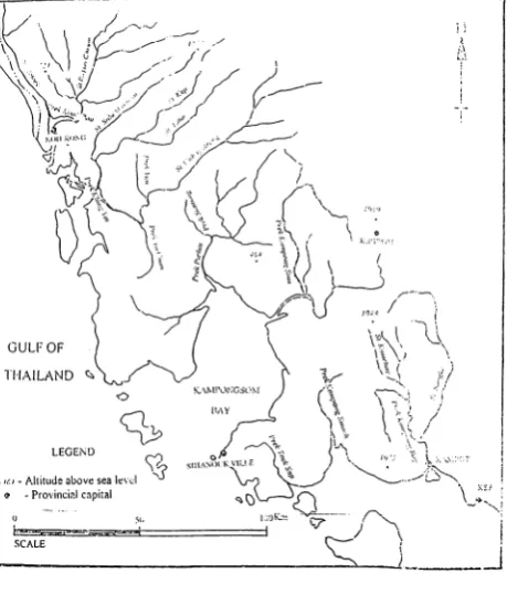
Figure 2 The Major Rivers in the Coastal Area of Cambodia Source: LUMO, MOAFF, 1995
\ .l‘.1 '1)...‘
\\uni}:N“) I“ I}/\ I/‘-..r\«'\\jJ-’/;
/
'1IQ:
I
I K‘ .. .°.. I ‘ l\.‘.':".
/—’—’fi
In \- /
' "". '1 \
l k\
u_V) ‘‘ ‘_"\(\,\ 1/ \"~‘~_¢. " "
\ __ ‘~' I
7 7 /
- \
The catchments of these rivers cover roughly 13,406 square kilometres.
Activities within the catchments of these rivers do not yet play an important role in
Carnbodia’s economy, but when taken into account there is unrealised potential for
hydroelectric power that could affect the functional integrity of the coastal areas.
A large part (73%) of the country's land area was under some form of forest
in 1969. However, the lastest forest inventory in 1991 by LandSat imagery measured the forest cover at 62% ( Thung, 1993 ). Sadoff, 1993 estimated the forest cover to be only 49% (MoE and UNDP, 1994).
Within Carnbodia’s coast, the mostly flat slope is dominated by mangrove
forests; raised beaches and sand deposits support land developments. The coastal
lands have an agriculture value and their best use is for urban, residential,
recreational, port development, and industrial developments. Considerable land
developments in this direction have taken place particularly along the coastal region
of Sihanoukville.
The average depth of Cambodia's sea is 50 meters with a maximum depth of
up to 75 meters. There are four main islands namely: Koh Kong, Koh Rong Sanlem,
and Koh Thmey and there are a lot of small islands near the coast such as Koh Tang,
Koh Pring, Koh Pous, and Koh Pol Waii.
Cambodia has a distinctly tropical climate characterised by high temperature
and rainfall. Thus, the country's coastal waters are relatively warm. Climatic
variation is minimal with a maximum average of 35°C in April and a minimum
average of 19°C in December (I-Ialcrow, 1994). The dominating monsoon winds
result in two distinct seasons: rainy and dry. The north-east monsoon prevails from
The armual rainfall accounts for more that one metre which occurs between May and October. The rainfall an coastal areas can be as high as in the inland areas
because of the south-west monsoon with the mountains serving as a natural wall.
The high rainfall promotes tropical rainforest growth, but at the same time induces
heavy erosion of exposed soils.
The coastal shoreline has tides twice daily with an amplitude of about 2.5
meters. Cambodia’s Gulf has a flat sea-bed and is not very deep with three types of
tides diurnal, semi-diumal, and mixed.
In accordance with oceanographic studies there is a rich fish and sea life in
the Cambodian Gulf. The coastal regional is favourable for agriculture, (coconut,
planatations) in particular due to the fact that it is rich in nitrogen, and potassium,
and phosphoric acid.
1.2 Significant Coastal and Marine Features
Cambodia’s coastal features are significant due to their contribution to the
coastal area’s biodiversity, productivity. The ftmctions of mangroves, coral and coral
reefs, islands and estuaries are presents their value to the national economy.
1.2.1 Mangrove Forest
The mangrove forest of Cambodia has an area of 83,700 hacters; it represents
0.7% of the country’s total land area (Mekong Secretariat and LUMO, 1992).
From an ecological point of view, mangrove forests are well know for their
high biological productivity and are significant for their input of nutrients into nearby
systems. They support valuable estuarine and near shore fisheries; act as nursery and
breeding grounds for many economically important fish and crustaceans; reduce
in turn prevent adjacent properties; and harbour unusual wildlife which provides
valuable opportunities for education, scientific study and tourism.
In Carnbodia’s coastal forests, there are 35 families, 53 genera, and 74 species
including plants that occur at the limit of salinity influence (Chhun, 1993). The
combination of these is to maintain a diversity of biota which is not only significant
for the conservation of biological diversity but also has direct economic significance
on Cambodia and all other countries situated around the Gulf of Thailand. The
coastal forests which are located in the catchments of the main rivers, as said, have
long been important in the protection of the soil and the regulation of the flow of
water and nutrients to the nearby coastal water.
1.2.2 Estuaries
Cambodia has two main estuaries which occur in the region around Koh
Kong province and near Kampot province. The estuaries are namely: Kaoh Poa and
Kep river. Scott, 1989, describes the estuary systems as a complex of tidal channels
and creeks, low island mangrove swamps, tidal mudflats and coastal lagoons. Both
rivers originate in the Cardamon range and discharge their flow in the Koh Kong
Bay. The Bay is protected fiom south-west storms by the large island of Koh Kong.
These estuaries are often highly productive areas due to the nutrients they receive
from the land and the sheltered environment that they provide.
There are significant mudflats areas in Cambodia characterised ofien
associated with estuaries. The main ones are situated adjacent to mangroves.
Mudflats serve as a habitat for very productive systems such as high diversities of
invertebrates living on and the mud, in particular molluscs, crustaceans a variety of
worms, and waterbirds. During low tide different birds feed on the biotic community
and during high tide, various vertebrates such as fish, shrimps, crabs and molluscs
Due to tidal effects, materials that come in to an estuary take time to be drawn out to sea. This forms the basis for to build up of nutrients and for estuaries to be
regarded as nutrient traps of high productivity.
1.2.3 Coral Reefs
In the Cambodia Sea, the coral and coral reefs are the most productive of the
marine ecosystem. They are found almost surrounding the islands in the Cambodia
sea (see map 3). However, there is limited information on the distribution of the
types of the corals and coral reefs.
Recently, some of the many species of coral on the reefs in the Cambodia
Sea have been identified as: Sarcophyton, Dploria, Pocillopora, Fungia, Hydrophora
Rigida, Moutiphore Aequituberculata, Favita, and Platygyra (Ouk, 1995).
1.2.4 Seagrasses
Seagrasses are found in the Kampong Som Bay and around some islands in
Kampot and Koh Kong provinces (see map 3). Some of the species of seagrass have
been identified as: Tropical Eelgrass (Enhalus acoroides), Fibber, Stand grass
(halodule pinifolia), Syringe grass (Syringodium isoetifolium), and Dugong grass
(Thela ria hempriehii) (Long, 1995).
From an ecological standpoint, seagrasses are known to:
contribute nursery areas, shelters and feeding sites for a large number of
invertebrates and fish;
give a significant proportion of the nutrients produced and transferred to adjacent
ecosystems such as the coral reefs;
Gulfof Thailand
3
o \ --- " Depth contour 1' 7‘J“ 7‘ Seagrass bed ' ,/j [/52 Well developed coral reef
£9 Coral reef in bad condition Q5 Mixed area
ro_'.'—_“““-“‘
for
Figure 3 Map ol'Cor.nl Reefs and S04:Grass BedsW5‘ 10.1.‘ Source: LUMO, MoAFF, 1995
1.2.5 Oil and Gas
At present, several zones in the marine and coastal area have been explored
and will continue to be explored for oil and gas. The country's economy may be
dominated by the oil and gas sector if these resources are found in sofficient
quantities in the offshore areas. Petroleum experts are of the opinion that Cambodia
has a high potential for natural gas and a modest potential _for oil. Tentative
estimates suggest that Cambodia's potential is of 1.5 to 3.5 trillion cubic fee of gas,
and 30 to 180 million barrels oil (MoE/UNDP, 1995).
1.3 Socio-Economic Features
This section will highlight the socio-ecomomic concerns of the coastal region
of the Kingdom of Cambodia.
1.3.1 Population and Employment
Cambodia has an estimated population of 10.4 million in 1995, (PADCO,
1995). By the year 2000, it is expected that the population will reach 14.6 million.
With 7.5% (675,000 people) of Cambodia’s inhabitants now recorded as
living in the coastal provinces, the population of the coastal region has grown rapidly
over the last year, but more that 80% of the people still live in the rural inland areas
(Sir. William, 1994). In particular, 77% of people live in Koh Kong; 58% in
Sihanoukville and 95% in Kampot provinces.
The population growth rate has been increasing during the last 20 years after
the civil war. From 1993-1995, the highest growth rate populations were in Koh
Kong province (4.6%); in Sihanoukville (2.7%); and in Kampot province (-0.6%)
In the coastal area, the average density of population is 79 people per square kilometre with household sizes between 5 and 6 persons per dwelling in the urban areas and slightly more than 5 persons per dwelling in the rural areas.
Similar to the country as a whole, approximately half of the population is
under 18 years of age. About 39% of the population is in the labour force. Of these
2.3% were openly unemployed (Minisu'y of Planning, 1995). Approximately 90% of
the people in the Sihanoukville and Koh Kong are ethnic Khmer and the other are
Vietnamese, Chinese, Cham, and Thai. For Kampot province no information was
available.
1.3.2 Institutions and Legislation
The Royal Government of Cambodia (RGC) was established by elections
supervised by the United Nations Transitional Authority of Cambodia (UNTAC) in
May 1993. The new Government institutions have been created with King Norodom
Sihanouk as head of state.
The Council of Ministers with responsibility over National Defence; Foreign
Affairs; Post and Communication; Public Works and Transport; Environment;
Agriculture, Forestry and Fisheries; Tourism; Economics and Finance; Commerce;
Information and Press; Education, Youth and Sports; Justice; Labour and Social
Welfare; Health; Rural Development; Industry, Mining and Energy; Religion Affairs;
Culture and Fine Arts; Planning; and Interior.
The country is divided into Provinces and Municipalities. The provinces are
divided into districts and communes. The Municipalities are divided into Khan and
The Ministry of Interior has taken direct responsibility for the supervision and
functioning of the 19 provinces and two municipalities (Sihanoukville and Kap City).
External services of the operational Ministry are now receiving functional direction
from their respective minist.ries from Phnom Penh city. The governor (and his
office) is the administrative and political representative of the central Govemment in
the province.
The country's highest court is the Supreme council chaired by the King. The
Supreme Court shall be establish by an organic law which shall determine its
composition and function.
The Ministry of Environment (established in 1993) is at present responsible
for environmental management in the country. The Government has already
recognised the importance of the environment for the future development of
Cambodia Recent studies, however, note that there are many agencies that have
been established at various levels, some concerned particularly with respect to coast
area management: highly sectoral and insufficiently co-ordinated efforts; overlapping
or duplication of statutory responsibilities.
Because the Ministry of Environment was recently established, the existing
legal authority is inadequate to ensure acceptable levels of environment quality and
administrative agencies have yet to implement their full legal power through their
proper translation into relevant rules and regulations.
The public awareness of the importance of the environment is poor.
HOWGVCI’.Step by step this can be improved by environmental education in the
primary schools at all levels. This is very important in regard to coastal issues.
Programme (UNEP), United Nations and Development Programme (UNDP) can play
an important role in needed educational endeavours.
1.3.3 Economic Performance
The main feature of the economy of Cambodia is the dominance of the
agriculture, industry and services sectors in terms of contribution to gross Domestic
Product (GDP). The contribution to GDP by industrial origin fi'om 1990-1995
indicated that GDP had increased at an annual average of 5.9% in real terms between
1990-1995. GDP growth in 1990-1995 was led by dynamic expansion in the
industry and services sectors of 10.9% and 8.3% per year. The 2.6% average annual
growth in the agricultural sector as a whole meant that agricultural production per
capita declined (Ministry of Planning, 1995).
With regard to the coastal region, there is very little information available
concerning the provinces’ economic activities. However, in 1994, Koh Kong’s GDP
was reported to be USD. 1.03 million of this, 52% is attributable to the industrial
sector, with 18% services sector, and 30% to agriculture (Provincial Department of
Finances and Economics, 1995). For Sihanoukville and Kampot provinces, is has
not been possible to obtain GDP data.
1.4 Coastal Economic Activities
1.4.1 Agriculture
The agricultural sector plays an important role in the economy. The main
agricultural crop is rice. This sector is the largest source of employment accounting
for approximately 80-85% of the labour force which contributes 63% to agriculture is
share of the GDP while livestock and fisheries 24%. Forestry contributes 10% and
The coastal land area covers 17,237 square kilometres and represents 9.5% of
the country with a population of 675,927 equal to 6.7% of the country's total
population (‘Ministry of Planning, 1995). Rice production from 1991 to 1995 represented in Table 1 below:
Tablel: Rice Production by year in the Coastal Provinces (T)
Year Coastal provinces
Kampot Sihanoulcville Koh Kong Total
1990-91 194,000 17,000 9,000 220,000 1991-92 147,000 15,000 8,000 170,000 1992-93 123,000 12,000 5,600 141,500 1993-94 128,000 63,000 6,000 197,000 1994-95 134,000 12,300 6,000 460,000
Source: Provincial Departments of Agriculture, 1995
(Kampot, Sihanoukville, and Koh Kong)
1.4.2 Fisheries
The fisheries of Cambodia are broadly categorised into the artisanal and
commercial sectors and contribute 5% of the GDP (World Bank, 1994). Fish
production comes fi'om inland, marine and aquaculture sources. The inland fisheries
is Cambodia's most important fishery in terms of both production and value. Marine
fishing is less developed but represents significant potential for growth.
The total commercial fisheries output between 1990 and 1992 averaged
(32%) marine fish; and 7,000 tons about (6%) aquacultural products (Fisheries Department, 1994).
Since 1990 to 1994, marine fisheries production has decreased from 39,900
tons to 30,000 tons. The decrease in marine products was reportedly due to over
fishing, destructive fishing methods, and depletion of fish habitats.
Approximately 10-13% of the total national fish catch was exported from
1992 to 1994 (DOF, 1995). However, more than half of the marine caught fish in
Koh Kong (67%) and Sihanoukville (52%) were exported in 1994. Kampot province
exported only 13% (DOF, 1995).
1.4.3 Aquaculture
From 1984 statistical data was collected separately for culture fish production
and showed an annual average growth rate of 28% per year between 1984 and 1992
(Fisheries Department, 1992). It appeared to have good prospects in terms of fish
production and economic contribution to Cambodia.
These activities consist of small-scale fish ponds and cages totalling an area
of 430.70 ha and 1386 cages (Chheng, 1993). The Department of Fisheries
identified 840 ha of potential coastal sites for shrimp farming. Among these are 238
ha in Koh Kong province which are currently under operation, 177 ha are under
construction and a fiirther 425 ha have been licensed but are not yet built. Most of
these areas identified for development lie in the inter-tidal mangrove forest.
1.4.4 Mangrove Harvesting
Mangroves have been exported on a limited scale for several uses in
In 1992, the 300 kilns were producing charcoal 24,000 tons of mangroves.
Approximately 100,000 tons of mangrove timber is yearly exported to foreign
countries, in particular Thailand. During 1992 the Government has made a contract
to provide 10,000 tons of mangrove timber with a Taiwan Company (Chheng, 1993).
In 1993, it is estimated that approximately 30% of charcoal product was for
local domestic use and 70% for illegal exported. It was reported that 244 large size
kilns were producing charcoal. An average size kiln of 6 meters diameter can covert
45 tons of mangrove wood into 15 tons of charcoal in one month (Ministry of
Enviromnent, Mangrove Working Group, 1994).
From these harvesting practicing point of view, mangrove forests are now
under embedded threats to the environment. The Ministry of Environment together
with the Ministry of Agriculture, Forestry and Fisheries should take steps in place to
regulate and control mangrove forests in order to ensure balance between the
economic interests and the environment protection.
The coastal inland forests are not exploited for commercial purposes but
some forests have been cleared and converted to sites for housing and industrial
projects.
1.4.5 Industry
In general, the industrial sector has been less developed within the coastal
region. However, in the whole country, it is noted that manufacturing GDP (at
constant prices) increased by 7.0% annually over the period of 1991 to 1995, despite
starting from a small base. The annual growth of industry as a whole was
significantly higher at 11.4% due to the much higher rate of expansion of the
As a result, the industrial share of GDP was 18.7% in 1995, with manufacturing accounting for 7.4%, mining 1.2%, electricity and water 0.2% and
construction 9.8% (Ministry of Planning, 1995).
There have been so far some small factories or plants constructed in the
coastal region of Cambodia, namely: a brewery, oil and gas refineries and factories, a
saw mill, a plywood factory, a silica mine, a cement plant, a salt recovery, industry,
and phosphate fertiliser plant. However, some of these industries are non-operational
at the present time due to a shortage of financial and technical assistance. Others are
still in operation including the brewery, the plywood, salt recovery and the industry.
1.4.6 Tourism
Cambodia is still limited in the development of tourism compared with other
countries in the region but the beaches of the coastal areas are important recreational
areas. The pristine beaches, blue seas, offshore coastal provinces with many islands,
shallow water, and easy accessibility make some of the beaches, in particular
Sihanoulcville, Kampot./Kep, and Koh Kong ideal for picnics, walking, bathing,
swimming, some fishing and other water-based recreational activities. The adjoining
forests give shade and resting places. The more important, and most accessible and
popular beaches get crowded during weekends and public holidays with local people
as well as foreign visitors. The number of tourists in the three coastal provinces in
1995 has been estimated at 110,206. Among these 90,000 were in Karnpot; 16,206
in Sihanoukville; and 400 in Koh Kong (Provincial Offices of Planning, 1995).
It is noted, therefore, that pure tourism arrivals for the whole country was
176,617 in 1994. An approximately 9% growth in tourism arrivals in Cambodia are
Japanese, Taiwan and Chinese. This indicated that positive growth in the potential
French, Chinese, American, and Japanese constitute the main source of
intemational tourists to Cambodia with American and Europeans showing strong
growth from 1993-1994. It was estimated that during the first nine months of 1995,
approximately a 22% increase would occur, corresponding to the same period in
1994 ( Ministry of Tourism, 1994).
1.4.7 Ports and Shipping
Sihanoukville and Phnom Penh Ports are the main ports of Cambodia. One
other in the Koh Kong province is involved in international trade with Singapore and
Thailand.
Sihanoukville port is the most important port of entry for sea going traffic
with offers port facilities of 10,000 to 12,000 dwt. The transit warehouse and the
container freight station are situated within the port area's approximately 21,600
square kilometers. The income was USD. 5.7 million in 1994 (Port Statistics, 1994).
Phnom Penh port is a river port, located at the confluence of the Mekong and
Tonle Sap River. It can discharge an average of only 200-250 tons a day (Curtis,
Grant, 1990). The port has 12 warehouses for 7,032 tonnes of cargo.
Koh Kong port can be accessible for vessels up to 300 tons at the dock or 500
tons at anchorage. This is port used for linking the vessels entering to Cambodia
from Singapore, Malaysia and Thailand. The 300 tonne vessels can proceed across
the Bay to Koh Kong town for loading to smaller ships, (Leng, 1995).
There are three vessels in the national merchant fleet with a total
displacement of 3,558 Gross Registered Tons (GRT). Among these one is a cargo
two ships are miscellaneous with ages of 23 years (Lloyd's register of Shipping,
1993).
1.5 Summary
Carnbodia’s coastal region including its marine and coastal water resources, is
important to the support of economic sectoral activities such as marine fisheries,
seaports, industry, tourism, and transportation. However, these waters have not
being used in a sustainable way. Therefore a new concept of sustainable
development and management needs to be established in Cambodia.
Chapter 2 will present the Coastal Sihanoukville Region as an example of a
coastal area in the Kingdom of Cambodia for further examination on the application
CHAPTER 11
THE COASTAL SIHANOUKVILLE REGION
This chapter focuses on the coastal Sihanoukville region and describes the
.local geographical area, the human activities and the initial land use zonings for the
region.
2.1 Sihanoukville Region
2.1.1 Geographical Description of Sihanoukville
Sihanoukville is a coastal municipality situated in the far south-westem part
of the Kingdom of Cambodia. It is bounded in the north by Koh Kong and in the
east by Kampot province. On the south and west is the Gulf of Thailand (see map 4).
Sihanoukville has an area of 868 kilometres and consists of three districts.
The town of Sihanoukville sprawls along its main arteries in a linear, low density
fashion. There are no identifiable central business districts but there are three zones
of development which can be identified: an administrative area; an industrial area
located close-by the port; and a large area of housing, commerce and tourism located
along the coast.
The city of Sihanoukville lies on several small undulating hills ranging from
42 meters to 100 meters in height. Fifteen kilometres outside the city lies Kang Keng
airport on a broad flat plain. To the south and west of the airport there are shallow
$-82 ...._QZD uosom
x::_o_> _E= u____$_:o:_::m._o222v9...»:
&
_u:w>;:>u
_
/\
Q
L
>\.I| T
«HWJ
..3
A
NV
w___> x:ocm£m .2a U
\/\.)\.
\.\...Q. 5.5. ..??2\5n.< .oQEmv_
wetlands and rice fields. The eastern side is dominated by a high mountain and Ream National Park.
The Sihanoukville coastline consists of approximately 40 kilometres of
undeveloped beaches. It winds unevenly with frequent bays and long narrow white
sandy beaches. There are numerous islands of varying size lying off the mainland,
including Koh Pous.
The Sihanoukville region is furnished with fresh water from two large rivers
the Teuk Sab and Kampong Smach.
2.1.2 Climate
The climate of the Sihanoukville is related to the monsoon periods. The
average daily temperature in Sihanoukville in 1994 was 27.1 degrees centigrade
peaking at 28.4 degrees centigrates in April, the hottest month, and falling to a
minimum of 26.1 degrees centigrade in January, the coolest.
Sihanoukville is in one of the provinces where largest precipitation. Rainfall
is on the ascent from May (424 mm), pea.king in June (994 mm), oscillating during
July (492 mm), and August (574 mm) before rising again in September (743.9), The
low precipitation rates are in November (63.5 mm) through to April (199.2)
indicating clearly the sharp fall during the north-eastem monsoon. ‘The average
rainfall is 333.3 mm (The Ministry of Agriculture, Forestry and Fisheries, 1994).
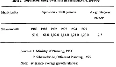
2.1.3 Population and Density
According to the lastest census in 1995, the population of Sihanoukville was
121,000 inhabitants: Sihanoukville proper - 47,000; Stung Hau - 10,500 and Prey
per sq.km well above the national figure of 52 persons per sq.km. Table 2 shows the
population growth in Sihanoukville.
Table 2: Population and growth rate in Sihanoukville, 1980-95
Municipality Population x 1000 persons Av.gr.rate/year
1993-95
Sihanoukville 1980 1987 1992 1993 1994 1995
51.0 61.0 l,07.0 1,l4.0 1,2l.0 1,20.0 2.7
Sources: 1. Ministry of Planning, 1994
2. Sihanoukville, Offices of Planning, 1995
Note: av.gr.rate- average growth rate/year
Approximately half of the population in Sihanoulcville is under 18 years of
age (UNDP, ILO, 1993). In Sihanoulcville about 90% of the people are ethnic
Khmer. Vietnamese represent 1.8%, Chinese 2.2%, and Cham 6% (Sihanoukville,
Department of Planning, 1995 ).
2.2 Human Activities in the Coastal Sihanoukville Region
2.2.1 Agriculture
There are approximately 20,000 ha of agricultural land in Sihanoukville. The
land cultivated decreased by 43% between 1985 and 1993 as indicated in table 3 below:
Table 3: Estimated Area of Agriculture Land in Sihanoukville, 1985-93
Years Estimated Area of Agriculture land (ha)
1985/87 35,300
1990 33,889
1991 22,672
1992/93 20,000
sources : 1. Cambodia Land cover Atlas (UNDP/FAO, 1987, 92, and 1993) 2. Sihanoukville, Agriculture Office, 1991
Table 4: The land use for agriculture products in Sihanoukville
Types of crop Area (ha) % of total
Annual plantations 12,848 79
- paddy fields 11,240 69
- other crops 1,608 10 Industrial land 2,149 13 - industrial land 1,000 6
- rubber 549 3
- fruit crops 600 4
Grass land 1,300 8
Total 16,297 100
Sources: Sihanoukville, Agriculture office, 1990
Note : data does not include Prey Nup district
Rice crops in Sihanoukville are naturally grown for consumption in the people and are considered to be the predominant production crops. In 1994/95 the total rice production was approximately 12,300 tons harvested from an area of 9,500 ha. However, in 1993/94 the rice harvested was only 6,300 tons harvested from areas
of only approximately 60% of this size due to a decline in harvest areas available due
to droughts and floods. On other reason, people are interested in perfonning more
work associated with the expanding tourism industry because of they make economic
survival sensitive to the tourism aspect (Sihanoulcville, Agriculture office, 1995).
The other crop productions like corn, black pepper, durian, and pineapple are
also produced in Prey Nup, Stung Hav Districts, and Mittapheap Khan in the
Sihanoukville.
2.2.2 Fisheries
Like other coastal provinces, the commercial and artisanal fishery in
Sihanoukville is carried out in inshore and offshore areas within the territory of
Cambodia’s Sea. There are many types of fishing gear used to catch fish in the
coastal Sihanoukville region. The primary fishing gear used are namely: purse
seiner, otter trawler, driftgillnetter, set gillnetter, bottom gillnetter, encircling
gillnetter, trapland liner, engine boat push netter, and boat seine. In 1995, there were
approximately 1,243 vessels. Among these 432 were not motorised and all of these
were less than 5 gross tons. Eight hundred and twenty were motorised with engines
of less than 10 hp., (Fisheries Department, 1995). All vessels are comparatively
small and are family owned. Boats with motors are used to fish further offshore
using purse seining, trawling, gillnetting, squid trapps, push netting and long living
In 1995 the volume of employment in the Sihanoukville fishing sector was
2,635 fishermen (about 755 families), representing 15% of the region's total
employment (Fisheries Department, 1995)
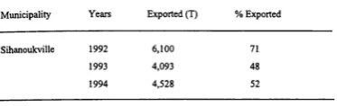
The fish production estimates of Table 5 from 1988-1994, indicate total fish
production at 60,625 tons. Of this 60,410 tons comes from fish caught and 215 tons
comes from aquaculture production.
The domestic price for marine fish is approximately USD. 0.2-0.3/kg and the
price for commercial marine fish for export is USD. 3-6/kg (FAO Mission, 1993). In
1994 more than 52% of the marine captu.reproduction of Sihanoukville was exported
(see table 6).
Table: 5 Fish Production from 1988-1994(T)
Municipality Years 1988 1989 1990 1991 1992 1993 1994
Sihanouk fish cap. 7,890 9,120 9,300 8,300 8,600 8,560 8,700
-ville fish aquac. 15 50 57 30 13 15 35
Source: Fisheries Department, 1995
Note : cap. capture; aquac. aquaculture
Table 6: Fish Capture Exported from 1992-94
Municipality Years Exported (T) % Exported
Sihanoukville 1992 6,100 71.
1993 4,093 48
1994 4,528 52
Source: Fisheries Department, 1995
2.2.3 Industry
In Sihanoulcville, the various types of industry include:
- Brewery
- Oil and Gas refineries and storage facilities
- Ice factory
- Saw mill
- Plywood factory
- Other handicraft and small-scale industry
The Brewery is located on the river just outside the Municipality of
Sihanoulcville. This beer can be purchased throughout the country. It is noted that
all the wastes discharged from this industry are released directly into the adjacent
rivers (fishermen, and local people reported, 1995).
The Oil and Gas refineries and storage facilities north of Sihanoukville port
were set up in 1967 to refine imported crude in a facility with an annual capacity of
600,000 tons. The refinery was expected to process 400,000 tons in 1969, and to
is leasing the site for use only as a storage and distribution facility for oil and gas. Oil and gas is distributed nation-wide via trucks from the Sihanoulcville petroleum storage facility.
The Plywood factory is located along the Prek Teok Sap river bank. It covers
an area of 17 ha and employs 400 local workers. It is run by a Taiwanese company.
The factory produces 3,500 cubis meters of plywood/month of which 95% is
exported to China and Taiwan (Sihanoukville, Office of Planning, 1995).
Within the small-scale industry, there are 233 handicrafis. They include
sewing, bakeries, brick making, fish steaming, shrimp processing, sewer line and jar
making, steal door factory, wood processing, fish source production, and purification
of drinking water.
2.2.4 Sihanoukville Port
The Port of Sihanoukville is located in the south-east part of Cambodia. It
was constructed in 1950 and 1960. The port has a well developed deep sea access
which handles approximately 40% of Carnbodia’s total port tonnage ($00,000 tons).
In 1994, the port had a total throughput of 522,000 tonnes with a vessel turnaround
of 403 vessels and 21,186 containers.
Sihanoukville’s oil terminal is also a part of this port, located 9 kilometres
fi'om the commercial port. This terminal, today, is operated by the Cambodian Fuel
Company (CFC) and Shell to import refined oil from Singapore. This terminal has a
storage of 60,000 cu.m capacity in operation and 80,00-100,000 cu.m (Diss. Leng,
A total employment of 1,009 people work for the port authority. It is estimated that in 1993 the combined total commodities passing through this port consisted of 68% import and 32% export (Diss. Leng, 1995).
Sihanoukville port revenue in 1994 was distributed 61% to stevedoring; 14%; to warehousingand port dues; and to 25% pilotage (Diss. Leng, 1995).
2.2.5 Tourism
Tourism is an activity which is increasing in importance in the region.
Current studies, noted that tourism demand is dominated by domestic tourism,
resident Cambodian nationals, NGO-persons and expatriates working in Cambodia.
In 1995, approximately 16,206 tourists were expected to visit Sihanoukville
region (Provincial Office of Planning, 1995). It is expected that 10% of the profit
made by the private tourism industry will go to the provincial government, mainly
through taxes (PADCO, 1995).
2.2.6 Coastal Conservation and Protection
Like other provinces, one of the national parks in coastal Sihanoukville was
established by HM King Norodom Sihanouk’s Decree concerning the creation and
designation of protected areas on 1 November, 1993 (see Royal Decree in appendix
1).
In the Park there are four subdistricts namely Rearn-Bot Rrong, Boeng
Taprum, Onha Heng and Ochrou and 23 villages. Under the decree this park is
directly managed by the Department of National Parks and Protected Area System
The park is named Preah Sihanouk National Park (Ream) and it covers a land
area of 15,000 ha. A full biological inventory of the park has not been undertaken.
A vegetation and land use map is currently under preparation by IUCN and MoE (IUCN and MoE, 1995).
Human activities in this park include farming, fishing, logging, and charcoal
production. The nature and extent of community use are dependent on the area's
natural resources. The extent of these future uses will depend upon the analysis by
the park planning team. This analysis will define more clearly the nature,
dependence and impact of various user groups regarding the natural resources (IUCN
and MoE, 1995).
2.3 Socio-Economic Profile
The Socio-economic profile is only available for Cambodia as a whole.
Sihanoukville is dominated by the port and to a lesser extent by the Carnbrew
brewery. However, unemployment levels are high. Primary sources of employment
include fishing, trade, and logging. The percent estimates of 1995 employment by
sector in Sihanoukville are shown table 7 below:
Table 7: Employment in Sihanoukville, 1995
1- farming 45%
2- trade and business 25%
and Enterprises
3- fishing 15%
4- govemment official 15%
Source: Sihanoukville, Department of Finance and Economics, 1995
According to United Nations Children's Fund (UNICEF), the per capita
income was approximately USD. 160 in 1992. In 1994, the United Nation Development Programme (UNDP) estimated that it had increased to USD. 252 ranking Cambodia as number 114 of 173 countries (173 having the lowest per capita
income). The figures fiom Sihanoukville city show that the majority of the
population are in the middle income bracket. The upper income (business people,
politician) constitutes 13%; middle income (public servants, petty traders) 48%; and lower income 39% (Ministry of Interior, 1994 cited in PADCO, 1995).
2.4 Sihanoukville National Planning Development
2.4.1 General status
Sihanoukville is a typical coastal region, in the sense that there are demands
for various production, services, and activities that the region and its environment
can fulfil. On the other hand, Sihanoukville can be considered a multiple use
resource and economical region for national and international economic
development.
In the short term, development of the region will face large demands for
urban expansion such as a new residential areas, industrial areas, port city centre,
tourism locations, and expanded airport facilities.
The Royal Govemment’s goals for Sihanoukville originally plarmed for
economic development in Cambodia through the rebuilding of tourism, industry, and
the expansion of the deep water port.
The Royal Government has already established initial land use zonings for
Sihanoukville development through direct research by expert teams with a Sub
National Committee for Land Management and Urbanisation. However, it is noted that the Master Plans are still with the Government and Assembly for approval.
The zonings and the land use (see map 5) have led to the definition of clear
and coherent zones as below: #
=fl==fl:=fl:=fl:=fl:=|I:
Zone 1- Port
Zone 2- Industries
Zone 3- City Centre
Zone 4- Residential
Zone 5- Tourism
Zone 6- Airport
Zone 7- Land Reserves
Source: Ly Chin Tomg, 1995
2.4.2 Description of Plans
The development plans for Sihanoukville are still under preparation by the
National Committee for Land Management and Urbanisation co-operating with the
Municipality. Some of the plans are involved directly with ministries to research and
response but for decided planning development must be approved by government.
2.4.2.1 Port Development Zone
The extension of the existing port zone is required to permit the expansion of
the port and to include a customs zone and a free trade zone. The maximum area
required is 140 ha of which 60 ha are proposed for reclamation from harbour.
The Petroleum Port, the discovery of layers of oil and gas demands the
creation at the refinery site of a petroleum port. A total extent: 600 ha on land + 400
The Port Development Zone is now under the responsibility of the Ministry
of Public Works and Transport. Lloyd's of London, 1995 reported that Japan's
International Co-operation Agency has signed a contract with the Cambodian
government to carry out a feasibility study on the development of the southern deep
seaport of Sihanoukville. The government and Japan signed a contract for the study
for 15 months, which they expect to start by early next year.
2.4.2.2 Industrial Development Zone
The industrial development zone was established in the Stung Hav district of
Sihanoukville called “Stung Hav - Sihanoukville Industry Zone" (sub-decree No 73,
1995). It is a special industrial development zone which includes general industry
activities, export processing industries, free industries, and all other services to assist
in the exploitation and production of the area.
The industry development zone covers approximately 1,150 ha. This area is
under study and the responsibility of the Ministry of Industry, Mines and Energy.
2.4.2.3 Tourism Development Zone
Two coastal zones are designed for tourism use in the Sihanoukville area:
Zone 1 covers a total land area of 321 ha, extending to the north beyond the
security area for the petrochemical industries.
Zone 2 covers 555 ha, extending to the south of Ochhoeu Teal to the southern
end of Phar Ream (Ly Chin Tomg, 1995).
The proposed study zones are now under the responsibility of the Ministry of
Tourism and a Malaysian company. At the end of 1995, tourism expansion in
Sihanokville was approved by the Royal Government as follows:
1. Three major developments for the south-west port-resort area of
Sihanoukville. All three projects form part of a USD. 1.3 billion casino resort and
infrastructure investment by Malaysia's Arison Sdn. Bhd Company.
2. A USD. 15 million renovation and expansion of the Independence Hotel,
to be completed by the YTL corporation of Malaysia, to be completed by 1997
3...5za.. $2.3... ft» 2.13 D 23.9.4: 2:3,. m .533. 2.2H... :5 ..:.5 B 9:33. 25.4.. _ _ :.22.. 2.3 G 3:61.10: c=.>_C« D :§.:3e._ 2.2 E n.=Sac.E:.. 3.239. ., ..I..,... .\..-2:. I:l::Ib.l|ral|i.l. 32 .2__a_8§.=m .:s:o-._=m 35cm W ENE .283. o___>x:o:a£m um o=._mE_. ..__...a . 31035:5 :32: -01 .2.. !i...-.._ §;_oN xanqflaz. 5: 8:3 21 m:=:s9_z.__» w.x_o....3 2w..5:o.. \_.. “mm....n.. I ..k. o>.ono_;-..mW.§~.. 5 .,\. ..s.. .
sfl
. / .3; .x.(C ,:./J./,..1...r.
./. r//J...,L...
., .
.... . ... .... ..um ..w\..%|.n$\l. .___ . .. ._Ag..." ...\. .. .I5.. T ._ .\.2.4.3 Rules for Protection of Port, Industry, and Tourism zones
The following directions for the development of these zones article 11 and 12
of sub-decree of zoning and administration of Sihanoulcvillepromulgated that:
2.4.3.1 Port and Industry Zones
To prohibit (solid) waste discharges in the sea, and of wastewater without
treatment.
For the petroleum port, to provide security arrangements to prevent the discharge
of oil in the event of an accident.
To require the installation of equipment for treatment of wastes, atmospheric
emissions of toxic gases or pollutions.
To require appropriate measures to eliminate industrial waste discharges.
To provide clear roadways specifically for the zones, which are independent of
road number 4.
2.4.3.2 Tourist Installations
Conceived to accommodate foreign tourists, these installations will have to meet
international standards, as to the level of rules of safety and sanitation for the
facilities and the grounds of these pennises.
The opening of these installations to the public is subject to obtaining certificates
of compliance.
The construction of new hotels will not be permitted outside tourist zones or
mixed zones (Tourism and Housing). The using of solar energy for these
facilities, will be recommended for the production of hot water and for air
2.5 Summary
Agriculture, tourism, the seaport, industry, and fisheries, play an important role in the local economic communities in the Sihanoukville region as in the national economy.
For the development of Sihanoukville to be sustainable, policy
recommendations and a management structure will be needed. Effective policy and
management processes will be required to preserve and protect the national resources
and pristine coastline.
Chapter 3 will consider and analyse the integration of environmental
CHAPTER III
INTEGRATING ENVIRONMENTAL CONSIDERATIONS INTO THE
SII-IANOUKVILLE COASTAL DEVELOPMENT
This chapter presents the current coastal and marine environmental issues,
problems and their causes in the coastal Sihanoukville region. It discusses the
possible impact fiom new national planning for development of this region. Plarmed
development activities include port expansion, increasing tourism, and oil and gas
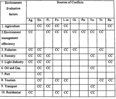
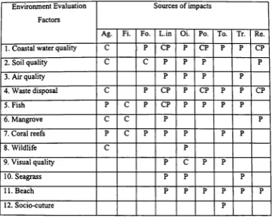
industrial development and expansion. Finally, conflicts between those activities
will be discussed and identified.
3.1 The Current Coastal and Marine Environmental Issues and Causes
There have been different types of issues and problems affecting the coastal
and marine environment in the Sihanoukville region. These are problems caused by
the human activities of the local community effort and national economic
development.
3.1.1 Fisheries Issues
Baseline information on the marine resources of this region is poor. No
reliable records on the composition of fish species in catches, or on stocks are
available (MoE and UNDU, 1994). However, inshore fish stocks in Sihanoukville
have been declining as a result of various factors, including:
. overfishing,
. use of harmfirl traditional methods, . ineffective enforcement of fisheries law, and
:50-3k)o—. data collection problems
3.1.1.1 Overfishing
The reports by fishermen and DOF indicate that fish stocks inshore in
Sihaoukville’s waters may be over-exploited. Poor fisheries management exists,
with no restrictions on the number of fishing vessels, or fishing licenses issued. Fish
stock depletion is indirectly evidenced by fishermen selling their vessels in
Sihanoukville showing that it is no longer economically viable to earn a living from
fishing in inshore areas. Fish catches, as shown in Table 5, have decreased steadily
since 1990.
Another reason for stock depletion is likely related to the fishermen using
gear, such as push nets and drag nets, in sea grass areas which depletes the stocks of
juvenile fish and destroys the sea grass ecosystem which is so vital to the existence
of many fish species. The degradation of juvenile fish stocks has a direct impact
both on the future inshore and offshore mature stocks.
3.1.1.2 Use of harmful traditional methods
The use of harmful traditional methods for fishing, such as dynamite, fish
poisons or intoxicants, have also affected fisheries production. The use of these
methods in the inshore areas, has resulted in the destruction of coral, mangrove, and
wetland areas. These methods can destroy the important breeding grounds for the
fish as well as the entire ecosystem needed to support the entire life cycle.
3.1.1.3 Ineffective enforcement of fisheries law
The institution and the enforcement of fisheries law to manage, monitor and
control fishing activities is weak. This is due in part to the lower financial salary of
governmental officials, and the lack of human resources trained in fisheries
management responsibilities.
3.1.1.4 Data collection problems
Data and dissemination of information on fish stocks, sustainable yield and
fishing grounds is either lacking or is not available to be used by DOF. This makes
assessing and controlling stock very difficult.
3.1.2 Port Issues
According to interviews with officials of the port authority, one of the biggest
problems is that there are no provisions for, or regulations related to, environmental
protection. Further, there are insufficient reception facilities (Ly, 1996). Thus,
marine pollution from activities such as cargo operations, 11111-Offfrom material
storage and spills fi'om bulk cargo handling are degrading the coastal water quality
and affecting marine resources with direct impact on fisheries, sea grass beds,
mangroves, and human health.
Impacts of port operations on the coastal area of Sihanoukville are greater
than they need to be. The main reason for this is that the government has not ratified
any international conventions such as the London Dumping Convention, Oil
Pollution Prepareness and Response Convention (OPRC), or the International
Maritime Dangerous Goods (IMDG) Code. The absence of these in the primary
legislation of the country is a major constraint in carrying out environmental
protection provisions relative to the shipping and port activities in Sihanoukville.