City of Echo
Transportation System Plan
Final Report
June 2001
Prepared by:
David Evans and Associates, Inc. and
Umatilla County in cooperation with
Oregon Department of Transportation
TABLE OF CONTENTS
CHAPTER 1: INTRODUCTION
...
1-1 PLANNING AREA...
1-1 PLANNING PROCESS...
1-1 Community Involvement...
1-2 Goals and Objectives...
1-2 Review and Inventory of Existing Plans, Policies, and Public Facilities...
1-2 Future Transportation System Demands...
1-3 Transportation System Potential Improvements...
1-3 Transportation System Plan...
1-3 Funding Options...
1-3 Recommended Policies and Ordinances...
1-3 RELATED DOCUMENTS...
1 - 4...
Other Transportation System Plans Prepared Concurrently with the Echo TSP 1-4 In-Process or Completed Plans
...
1-4 Other State Plans...
1-6 CHAPTER 2: GOALS AND OBJECTIVES...
2-1 OVERALL TRANSPORTATION GOAL ... 2-1 Goal 1...
2-1 Goal 2 ... 2-1 Goal 3...
2-2 Goal 4 ... 2-2...
CHAPTER 3: TRANSPORTATION SYSTEM INVENTORY 3-1
STREET SYSTEM ... 3-1 City Street Classification
...
3-1 Street Layout...
3-2 State Highways...
3-2 Lexington-Echo Highway...
3-3 GENERAL PAVEMENT CONDITIONS ... 3-3City Streets
...
3-3 State Highways...
3-3 BRIDGES ... 3-4 PEDESTRIAN SYSTEM ... 3-4 BIKEWAY SYSTEM ... 3-4 PUBLIC TRANSPORTATION ... 3-5 RAIL SERVICE ... 3-5 AIR SERVICE ... 3-6 PIPELINE SERVICE ... 3-6 WATER TRANSPORTATION ... 3-6 CHAPTER 4: CURRENT TRANSPORTATION CONDITIONS...
4-1TRAFFIC VOLUMES ... 4-1 Average Daily Traffic ... 4-1 Street Capacity ... 4-1 TRANSPORTATION DEMAND MANAGEMENT MEASURES ... 4-3 Alternative Work Schedules
...
4-3Echo Transportation System Plan June 2001
...
TRAVEL MODE DISTRIBUTION 4-4
ACCIDENT ANALYSIS ... 4-5 Historic
...
4-5 CHAPTER 5: TRAVEL FORECASTS...
,...
5-1 LAND USE ... 5-1 Historic Growth...
5-2 Projected Growth...
-5-2 TRAFFIC VOLUMES ... 5-3Historic
...
5-3 Future Traffic Volumes...
5-4 HIGHWAY SYSTEM CAPACITY ... 5-5 Analysis Results...
5-6 CHAPTER 6: IMPROVEMENT OPTIONS ANALYSIS...
6-1 EVALUATION CRITERIA...
6-2 COUNTY BRIDGE REPLACEMENT PROJECT ... 6-2 IMPROVEMENT OPTIONS EVALUATION ... 6-2 SUMMARY ... 6-10...
CHAPTER 7: TRANSPORTATION SYSTEM PLAN 7-1
STREET DESIGN STANDARDS ... 7-1 Existing Street Standards ... 7-1
...
Recommended Street Standards 7-1
ACCESS MANAGEMENT ... 7-5 Access Management Techniques
...
7-5...
Recommended Access Management Standards 7-6
Access Management on State Highways
...
7-7 MODAL PLANS ... 7-11...
Street System Plan 7 - 1 1
...
Pedestrian System Plan 7-13
...
Bicycle System Plan 7-14
Transportation Demand Management Plan
...
7 1 5...
Public Transportation Plan 7-16
...
Rail Service Plan 7-16
Air Service Plan ... 7-17 ...
Pipeline Service 7-17
Water Transportation ... 7-17
...
TRANSPORTATION SYSTEM PLAN IMPLEMENTATION PROGRAM 7-17
...
20-Year Capital Improvement Program 7-17
CHAPTER 8: FUNDING OPTIONS AND FINANCIAL PLAN
...
8-1...
HISTORICAL STREET IMPROVEMENT FUNDING SOURCES 8-1
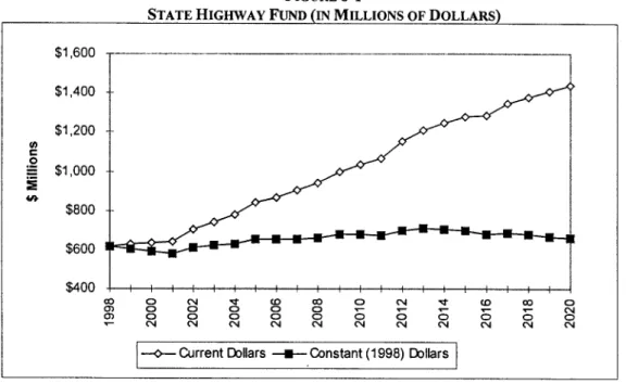
Transportation Funding in Umatilla County ... 8-2 Historical Revenues and Expenditures in the City of Echo ... 8-3 Transportation Revenue Outlook in the City of Echo ... 8-4 REVENUE SOURCES ... 8-7 Property Taxes ... 8-7 System Development Charges ... 8-8 State Highway Fund
...
8-8Local Gas Taxes
...
8-8...
Vehicle Registration Fees
. .
8-9Local Improvement Districts
...
8-9 GRANTS AND LOANS ... 8-9...
Bike-Pedestrian Grants 8-9
Access Management
...
8-10 Enhancement Program...
8-10 Highway Bridge Rehabilitation or Replacement Program...
8-10 Transportation Safety Grant Program...
8-10...
Federal Transit Administration (FTA) Section 53 1 1-Non-urbanized Area Formula Program 8-10 Surface Transportation Program (STP) Funds...
8-11 Department of Labor Welfare-to-Work Program...
8 - 1 1 FTA Section 53 10 Discretionary Grants...
8-11 Special Transportation Fund...
8-11...
County Allotment Program 8-11
Immediate Opportunity Grant Program
...
-8- 12...
Oregon Special Public Works Fund 8-12
...
Oregon Transportation Infrastructure Bank 8-12
ODOT FUNDING OPTIONS ... 8-13 FINANCING TOOLS ... 8-13 General Obligation Bonds
...
8 -14...
Limited Tax Bonds 8-14
...
Bancroft Bonds 8-14
FUNDING REQUIREMENTS ... 8-15
...
CHAPTER 9: RECOMMENDED POLICIES AND ORDINANCES 9-1
...
ELEMENTS REQUIRED BY THE TRANSPORTATION PLANNING RULE 9-1
APPROVAL PROCESSES FOR TRANSPORTATION FACILITIES ... 9-2 Recommended Policies for Approval Process
...
9-2 Recommended Ordinances for Approval Processc...
9-2 PROTECTING EXISTING AND FUTURE OPERATION OF FACILITIES ... 9-4...
Recommended Policies for Protection of Transportation Facilities 9-4 Recommended Access Control Ordinances
...
9-4 PROCESS FOR COORDINATED REVIEW OF LAND USE DECISIONS ... 9-8 Recommended Policies for Coordinated Review...
9-8 Recommended Process for Applying Conditions to Development Proposals ... 9-9 Recommended Regulations to Provide Notice to Public Agencies ... 9-9 Recommended Regulations to Assure that Amendments are Consistent with the Transportation System...
Plan 9-10
SAFE AND CONVENIENT PEDESTRIAN AND BICYCLE CIRCULATION ... 9-11 Recommended Ordinances for Bicycle and Pedestrian Circulation and Access ... 9-11
Echo Transportation System Plan June 2001
APPENDICES APPENDIX A: REVIEW OF CITY PLANS AND POLICIES APPENDIX B: 1997 MAJOR STREETS INVENTORY
APPENDIX C: UMATILLA COUNTY POPULATION DISCUSSION
-
UMATILLA COUNTY POPULATION ANALYSISLIST OF TABLES
TABLE 4-1 : LEVEL OF SERVICE CRITICAL FOR ARTERIAL AND COLLECTOR STREETS ... 4-2 TABLE 4-2: SUMMARY OF OPERATIONS AT LEXINGTON ECHO HIGHWAY AND DUPONT STREET ... 4-3 ...
TABLE 4-3: DEPARTURE TO WORK DISTRIBUTION 4-4
...
TABLE 4-4: JOURNEY TO WORK TRIPS 4-5
...
TABLE 4-5: HISTORIC ACCIDENT RATES FOR STATE HIGHWAYS 4-5
TABLE 4-6: ACCIDENT SUMMARY FOR LEXINGTON ECHO HIGHWAY ... 4-6
...
TABLE 5- 1 : UMATILLA COUNTY POPULATION TRENDS 5-1
...
TABLE 5-2: HISTORIC TRAFFIC GROWTH RATES ON STATE HIGHWAYS 5-4
...
TABLE 5-3: FORECAST TRAFFIC VOLUMES AND TOTAL GROWTH ON STATE HIGHWAYS 5-5
TABLE 5-4: SUMMARY OF FUTURE OPERATIONS AT LEXINGTON ECHO HWY AND DUPONT STREET 5-5 TABLE 6-1 : ROAD MAINTENANCE AND IMPROVEMENT PROGRAM PROJECT LIST ... 6-9
...
TABLE 6-2: TRANSPORTATION IMPROVEMENT OPTIONS: RECOMMENDATION SUMMARY 6-11
TABLE 7-1 : RECOMMENDED STREET DESIGN STANDARDS ... 7-2 TABLE 7-2: RECOMMENDED ACCESS MANAGEMENT STANDARDS ... 7-6
...
TABLE 7-3: MINIMUM SPACING STANDARDS APPLICABLE TO FREEWAY INTERCHANGES 7-13
TABLE 7-4: RECOMMENDED STREET SYSTEM PROJECTS ... 7-13 TABLE 7-5: RECOMMENDED PEDESTRIAN PROJECTS ... 7-11
...
TABLE 7-6: CAPITAL IMPROVEMENT P R O G M 7-18
...
TABLE 8- 1 : SOURCES OF ROAD REVENUES BY JURISDICTION LEVEL 8-1
TABLE 8-2: UMATILLA COUNTY TRANSPORTATION-RELATED REVENUES ... 8-2
...
TABLE 8-3: UMATILLA COUNTY TRANSPORTATION-RELATED EXPENDITURES 8-3
...
TABLE 8-4: UMATILLA COUNTY BICYCLE PATH FUND REVENUES AND EXPENDITURES 8-3
...
TABLE 8-5: CITY OF ECHO STREET FUND REVENUES 8-4
...
TABLE 8-6: CITY OF ECHO STREET FUND EXPENDITURES 8-4
TABLE 8-7: ESTIMATED RESOURCES AVAILABLE TO CITY OF ECHO FROM STATE HIGHWAY FUND .. 8-6 TABLE 8-8: RECOMMENDED PROJECTS AND FINANCIAL RESPONSIBILITY ... 8-16
...
Echo Transportation S. ystem Plan June 2001
LIST OF FIGURES
Follows Page FIGURE 1 . 1 : PLANNING AREA ... 1-2
FIGURE 3-1: ROADWAY FUNCTIONAL CLASSIF-ICA~ON ... 3-2
FIGURE 3-2: PEDESTRIAN AND BIKEWAY SYSTEM INVENTORY ... 3-4
FIGURE 4- 1 : EXISTING AVERAGE DAILEY TWO-WAY TRAFFIC VOLUMES ... 4-2
FIGURE 6- 1 : POTENTIAL TRANSPORTATION SYSTEM IMPROVEMENTS ... 6-2
FIGURE 6-2: POTENTIAL TRANSPORTATION SYSTEM IMPROVEMENTS (OPTION 12) ... 6-3
...
FIGURE 7-1: RECOXL~LENDED STREET S T ~ D A R D S - ARTWAL STREETS, COLLECTOR STRRETS AND ALLEYS 7-3 FIGURE 7-2: RECOMMENDED STREET STANDARDS - LOCAL STREETS (OPTION 1) ... 7-2 FIGURE 7-3: RECOMMENDED STREET STANDARDS - LOCAL STREETS (OPTION 2) ... 7-2 FIGURE 7-4: RECOMMENDED STREET STANDARDS
-
LOCAL STREETS (OPTION 3) ... 7-2 FIGURE 7-5: MINIMUM SPACING STANDARDS APPLICABLE TO FREEWAY INTERCHANGES ... 7- 10...
CHAPTER 1: INTRODUCTION
The City of Echo Transportation System Plan (TSP) guides the management of existing transportation facilities and the design and implementation of future facilities for the next 20 years. This Transportation System Plan constitutes the transportation element of the city's Comprehensive Plan and satisfies the requirements of the Oregon Transportation Planning Rule established by the Department of Land Conservation and Development. It identifies and prioritizes transportation projects for inclusion in the Oregon Department of Transportation's (ODOT's) Statewide Transportation Improvement Program (STIP).
PLANNING AREA
The City of Echo Transportation System Plan planning area covers the entire area within the Echo Urban Growth Boundary (UGB). The planning area is shown on Figure 1-1. Roadways included in the Transportation System Plan fall under three jurisdictions: the City of Echo, Umatilla County, and the state of Oregon.
Echo is located in the northwestern portion of Umatilla County in the northeastern corner of Oregon. It is a small agricultural community with a population of approximately 630 people. The City is divided into two distinct grids by the Union Pacific Railroad track. The Umatilla River bound it on the west and development is restricted in the east by the existence of Furnish Ditch and Feed Canal; however, there are residential dwellings above these canals and Golf Course Road. The canals cut westward through the largely undeveloped area north of the City but within the UGB. Commercial and city services are concentrated along Main Street (Lexington-Echo Highway) east to west, and Thielsen Street (County Road 1300) north to south. There is a light industrial area located along the railroad line and Thielsen Street near the northern city limits, and an area zoned for commerciaVlight industrial off Thielsen Road near the 1-84 freeway interchange.
Most of the city streets in Echo are paved, with the exception of a few dead-end streets. County and state roads function as arterials and collectors within Echo. The Lexington-Echo Highway is the only state roadway within the UGB, and county roads 1300 (locally called Thielsen Street and Rieth Road) and 1357 (locally called Kennedy Road) are the only county roads. The City has jurisdiction over the rest of the existing roadways.
Thielsen Street becomes Thielsen Road north of Main Street. This road is paved and connects Echo to 1-84, US 395, and the Stanfield UGB north of the City. Kennedy Street extends to Ramos Lane south of the UGB. Also, the Lexington-Echo Highway (Main Street and Gerone Street through town) connects with 1-84 east of the City and OR 207 west of Echo.
The Union Pacific Railroad runs northwest to southeast through the middle of the City.
Agriculture, food processing, wood products, tourism, manufacturing, and recreation serve as the principal industries within Umatilla County. Employment in agriculture and wood products is subject to seasonal variations, which tend to parallel growing and construction seasons.
PLANNING PROCESS
The Echo Transportation System Plan was prepared as part of an overall effort in Umatilla County to prepare TSPs for Umatilla County and eight small municipalities: the cities of Adams, Athena, Echo, Helix, Pilot Rock, Stanfield, Ukiah, and Weston. Each plan was developed through a series of technical analyses
Echo Transportation System Plan June 2001
combined with systematic input and review by the county, the cities, the management team, the Transportation Advisory Committee (TAC), ODOT, and the public. The TAC consisted of staff, elected and appointed officials, residents, and business people from Umatilla County, and the eight cities. Key elements of the process include:
Involving the Echo community (Chapter 1) Defining goals and objectives (Chapter 2)
Reviewing existing plans and transportation conditions (Chapters 3 , 4 ; Appendices A and B) Developing population, employment, and travel forecasts (Chapter 5, and Appendix C) Developing and evaluating potential transportation system improvements (Chapter 6) Developing the Transportation System Plan and a capital improvement plan (Chapter 7) Evaluate funding options and develop financial plan (Chapter 8)
Developing recommended policies and ordinances (Chapter 9) Community Involvement
Community involvement is an integral component in the development of a TSP for the city of Echo, Umatilla County and each of the other seven cities covered under the Umatilla County TSP process. Since the communities faced many similar transportation and land use issues, a public involvement program involving all the jurisdictions, was used. The process allowed for individual attention when needed, and general problem solving for all jurisdictions as appropriate. Several different techniques were utilized to involve each local jurisdiction, ODOT, and the general public.
A combined management team and transportation advisory committee (TAC) provided guidance on technical issues and direction regarding policy issues to the consultant team. Staff members from each local jurisdiction, from ODOT, and a local resident from each community served on the TAC. This group met
several times during the course of the project.
The second part of the community involvement effort consisted of community meetings within Umatilla County. The first public meeting was held in June 1998. The Echo general public was invited to learn about the TSP planning process and provide input on transportation issues and concerns. A second public meeting was held in July 1998. The third and final public meeting was held in September 1998. The public was notified of the public meetings through public announcements in the local newspapers and on the local radio station.
Goals and Objectives
Based on input from the community, the county, and the management team/TAC, a set of goals and objectives were defined for the TSP. These goals and objectives were used to make decisions about various potential improvement projects. They are described in Chapter 2.
Review and Inventory of Existing Plans, Policies, and Public Facilities
To begin the planning process, all applicable Echo and Umatilla County transportation and land use plans and policies were reviewed and an inventory of public facilities was conducted. The purpose of these efforts -
June 2001 Echo Transportation System Plan
was to understand the history of transportation planning in the Echo area, including the street system improvements planned and implemented in the past, and how the City is currently managing its ongoing development. Existing plans and policies are described in Appendix A of this report.
The inventory of existing facilities catalogs the current transportation system. The results of the inventory are described in Chapter 3, while Chapter 4 describes how the system operates. Appendix B summarizes the inventory of the existing arterial and collector street system.
Future Transportation System Demands
The Transportation Planning Rule requires the Transportation System Plan to address a 20-year forecasting period. Future traffic volumes for the existing and committed transportation systems were projected using ODOTYs Level I
-
Trending Analysis methodology. The overall travel demand forecasting process isdescribed in Chapter 5.
Transportation System Potential Improvements
Once the travel forecasts were developed, it was possible to evaluate a series of potential transportation system improvements. The evaluation of potential transportation improvements was based on a qualitative review of safety, environmental, socioeconomic, and land use impacts, as well as estimated cost. These improvements were developed with the help of the local working group, and they attempt to address the concerns specified in the goals and objectives (Chapter 2). After evaluating the results of the potential improvements analysis, a series of transportation system improvements were selected. These recommended improvements are described in Chapter 6.
Transportation System Plan
The Transportation System Plan addresses each mode of transportation and provides an overall implementation program. The street system plan was developed from the forecasting and potential improvements evaluation described above. The bicycle and pedestrian plans were developed based on current usage, land use patterns, and the requirements set forth by the Transportation Planning Rule. The public transportation, air, water, rail, and pipeline plans were developed based on discussions with the owners and operators of those facilities. Chapter 7 details the plan elements for each mode.
Funding Options
The city of Echo will need to work with Umatilla County and ODOT to finance new transportation projects over the 20-year planning period. An overview of funding and financing options that might be available to the community are described in Chapter 8.
Recommended Policies and Ordinances
Suggested Comprehensive Plan policies and implementing zoning and subdivision ordinances are included in Chapter 9. These policies and ordinances are intended to support the TSP and satisfy the requirements of the Transportation Planning Rule (TPR).
RELATED DOCUMENTS
The City of Echo TSP addresses the regional and rural transportation needs in the City. There are several other documents which address specific transportation elements or areas in Umatilla County that may directly or indirectly impact transportation elements in and around Echo.
Other Transportation System Plans Prepared Concurrently with the Echo TSP
In addition to the Echo TSP, seven small city TSPs were prepared in conjunction with the Umatilla County TSP project. These documents include:
City of Adams TSP City of Athena TSP City of Helix TSP City of Pilot Rock TSP City of Stanfield TSP City of Ukiah TSP City of Weston TSP I n Process o r Completed Plans
The following references were reviewed for relevance to the city of Echo TSP process:
Echo Comprehensive Plan
The Echo Comprehensive Plan was adopted in 1979 and was due for a periodic review in 1998. The plan provides a statement of the City's goals and policies for guiding the future growth and development of the City. Two of the City's 13 goals strongly impact the development of the Transportation System Plan; Public Facilities and Services. The City's transportation goal is, "To provide and encourage a safe, convenient and economic transportation system." Four policies are listed to implement this goal. They include repaving city streets and providing curbs and sidewalks as resources are available; encouraging the Union Pacific Railroad to landscape its right-of-way through the City; to encourage Umatilla County to improve County Road Number 1300 (Thielsen Road) between the City and the 1-84 Freeway interchange and to plan for adequate access to adjacent property; and to work with Umatilla County to develop joint policies concerning local roads and streets within the Urban Growth Boundary.
The City's overall goal for public facilities and services is, "To plan and develop a timely, orderly, and efficient arrangement of public facilities and services to serve as a framework for urban development." Applicable policies include: J) 4. To develop, maintain, update, and expand police and fire services, streets and sidewalks. J) 10. To identify approximate location of future streets, water tank sites, and other public facilities; and J) 11. to require necessary on-site public facilities to be provided in new subdivisions including ... streets.
The Echo Comprehensive Plan Technical Report gives a good economic and social history of the City, but is highly outdated regarding current economic and land use conditions. The population projections exemplify
June 2001 Echo Transportation System Plan
this problem. In 1977, the Technical Report population projections for 1995 were 2,514 to 4,064 people. In reality, Echo's population was 630 in 1999.
Umatilla County Comprelrensive Plan
The Umatilla County Comprehensive Plan was written in 1983 to meet the statewide requirements for planning. It was last amended in 1987. The plan is broken into three sections: the Introduction; Plan Elements - Findings, Recommended Policies; and the Plan Map. The Plan Elements section is broken into sections dealing with the fourteen goals. This includes a Transportation Element with findings and recommended policies.
Urnatilla County Development Code
The Umatilla County Development Ordinance was adopted in 1983, and last amended in November of 1991. In 1997 this ordinance was recodified and retitled as Chapter 1528 Development Code. The portions of the code most relevant to the Transportation System Plan include sections on off-street parking requirements, driveways, and road standards. Amendments to the development code include road standards for county roads.
Traffic Impact Analysis
A Traffic Impact Analysis for the Wal-Mart Distribution Center, located on 220 acres in rural Umatilla County, approximately 1 112 miles north of Stanfield, and 2 miles south of Hermiston was prepared in October 1994, and revised in August 1995. The project includes a distribution center with approximately 1.2 million square feet of floor area and paved parking, receiving and shipping areas. Traffic generated is estimated at about 700 trucks per day and about 300 passenger vehicles per day. The purpose of the study was to assess the traffic impact of the proposed development on the nearby road system and to recommend any required mitigation measures. Primary roadways impacted by the development include: Feedville Road, US 395, US 730, 1-82? and 1-84. A more detailed summary of the report findings is available in Appendix A of this TSP.
Stanfield Community Visioning and Buildable Land Inventory
The Stanfield Community Visioning and Buildable Lands Inventory project addresses the following issues and community needs:
An influx, currently in progress, of numerous large industrial and institutional employers in western Umatilla County and northeastern Morrow County including: the Two Rivers Prison, a Wal-Mart distribution center north of Stanfield, the Hinkle Railyard expansion, and increased activity at the Umatilla Army Depot.
Anticipated rapid population growth will generate demand for residential and commercial land development as workers and their families migrate to the area. This growth, together with major increases in freight movement associated with the new employment centers, will produce significant travel demand increases and pattern changes.
The capacity of the existing town center to accommodate growth and redevelopment is severely *-. constrained. The central business district and much of the residential area around it are within the
100-year floodplain boundary. In addition, Highway 395 through the center of town is expected to carry increasing freight movement between 1-84 and the new Wal-Mart distribution center.
US 395 North Corridor Plan
The US 395 Corridor Plan prepared by OTAK, Inc. and Kittelson and Associates, Inc., covers a section of US 395 extending from 1-84 (including the city of Echo) to US 730 in the city of Umatilla. This plan addresses transportation system improvement projects and an access management plan for the entire US 395 north corridor.
Airport Master Plans
The 1986 Hermiston Municipal Airport Master Plan Update provides a comprehensive analysis of the Hermiston Airport including an inventory of facilities, a discussion of use for a twenty-year planning period (ending in 2006), and recommendations for facility improvements. The introduction of the plan also provides a good overview of all the major transportation facilities serving Hermiston and northeast Oregon. This plan is currently being updated by Aaron Fagre & Associates.
The primary objective of the Master Plan Update for Eastern Oregon Regional Airport at Pendleton was to re-evaluate the recommendations of previous airport planning studies, to determine the long-range requirements for airport development, to identify and assess development alternatives, and to produce an airport development/improvement plan that will yield a safe, efficient, economical, and environmentally acceptable public facility with capacity for future air transport needs of the eastern Oregon area. When approved by the various local, regional, state, and federal agencies, the Airport Master Plan represents the long-term intentions of all agencies regarding the location and extent of airport improvements. This permits long-range programming and budgeting, reduces lengthy review periods for each project, and provides for orderly and timely development. A more detailed summary of this reference is provided in Appendix A.
Other State Plans
In addition to the ODOT corridor strategy, coordination with the following state plans is required: Oregon Transportation Plan (1992)
Oregon Highway Plan (1999)
Oregon Bicycle and Pedestrian Plan (1995) Oregon Public Transportation Plan (1996) Oregon Rail Freight Plan (1994)
Oregon Rail Passenger Policy and Plan (1 992) Oregon Traffic Safety Action Plan (1 995) Oregon Aviation System Plan (in development).
June 2001 Echo Transportation System Plan
CHAPTER 2: GOALS
AND
OBJECTIVESThe purpose of the TSP is to provide a guide for Echo to meet its transportation goals and objectives. The following goals and objectives were developed from information contained in the city's Comprehensive Plan and reflect public concerns as expressed during public meetings. An overall goal was drawn from the plan, along with more specific goals and objectives. Throughout the planning process, each element of the plan was evaluated against these parameters.
OVERALL TRANSPORTATION GOAL
To provide and encourage a safe, convenient, and economic transportation system.
Goal 1
Preserve the function, capacity, level of service, and safety of the nearby highways. Objectives
A. Develop access management standards.
B. Develop alternative, parallel routes where practical. C. Promote alternative modes of transportation.
D. Promote transportation demand management programs. E. Promote transportation system management.
F. Develop procedures to minimize impacts to and protect transportation facilities, corridors, or sites during the development review process.
Goal 2
Ensure that the road system within the City is adequate to meet public needs, including those of the transportation disadvantaged.
Objectives
A. Meet identified maintenance level of service standards on the county and state highway systems.
B. Pave city streets and provide curbs and sidewalks as resources are available.
C. Deveiop and adhere to a five-year road program for maintenance and improvement of the existing city road system.
D. Review and revise, if necessary, street cross section standards for local, collector, and arterial streets to enhance safety and mobility.
F. Evaluate the need for traffic control devices.
G. Evaluate the safety of the street system and develop plans to mitigate any safety hazards.
H. Encourage Union Pacific Railroad to landscape its right-of-way through the City. Goal 3
Improve coordination among Echo and nearby cities, the Oregon Department of Transportation (ODOT), the US Forest Service (USFS), the Federal Highway Administration (FHWA), and the county.
Objectives A. B. C. D. E. F. G. Goal 4
Work with Umatilla County to coordinate roadway maintenance and improvements and to develop joint policies concerning local roads and streets within the Urban Growth Boundary. Cooperate with ODOT in the implementation of the Statewide Transportation Improvement Program (STIP).
Work with the county in establishing right-of-way needed for new roads identified in the Transportation System Plans.
Take advantage of federal and state highway funding programs.
Encourage the county to improve the existing road systems to and within the City. In particular, encourage Umatilla County to improve County Road No. 1300 (Thielsen Street) between the City and the 1-84 freeway interchange and plan for adequate access to adjacent property. This may include widening the road, additional signage, and adequate pedestrian amenities.
Work with ODOT to improve safety conditions at the 1-84 and Thielsen Road Interchange. Consider pooling resources with other cities and the county to provide services that benefit areas both in and outside the City.
Increase the use of alternative modes of transportation (walking, bicycling, and public transportation) through improved access, safety, and service.
Objectives
A. Cooperate with other cities and the county to pursue an inter-city transit service. B. Encourage the rerouting of Greyhound to pass through the community.
C. Provide sidewalks or shoulders and safe crossings on collectors and arterials.
D. Explore opportunities for bicycle facilities and coordinate with the county bicycle plan. E. Seek Transportation and Growth Management (TGM) and other funding for projects
June 2001 Echo Transportation System Plan
CHAPTER 3: TRANSPORTATION SYSTEM INVENTORY
As part of the planning process, David Evans and Associates, Inc, conducted an inventory of the existing transportation system in Echo. This inventory covered the street system as well as the pedestrian, bikeway, public transportation, rail, air, water, and pipeline systems.
STREET SYSTEM
The most common understanding of transportation is of roadways carrying cars and trucks. Most transportation dollars are devoted to building, maintaining, or planning roads to carry automobiles and trucks. The mobility provided by the personal automobile has resulted in a great reliance on this form of transportation. Likewise, the ability of trucks to carry freight to nearly any destination has greatly increased their use.
Encouraging the use of cars and trucks must be balanced against costs, livability factors, the ability to accommodate other modes of transportation, and negative impacts on adjacent land uses; however, the basis of transportation in nearly all American cities is the roadway system. This trend is clearly seen in the existing Echo transportation system, which consists almost entirely of roadway facilities for cars and trucks. Because of the rural nature of the area, the street system will most likely continue to be the basis of the transportation system for at least the 20-year planning period; therefore, the emphasis of this plan is on improving the existing street system for all users.
The existing street system inventory was conducted for all highways, arterial roadways, and collector roadways within Echo, as well as those in Umatilla County that are included in the TSP planning area. Inventory elements include:
Street classification and jurisdiction Street width
Number of travel lanes
Presence of on-street parking, sidewalks, or bikeways Speed limits
General pavement conditions
Figure 3-1 shows the roadway functional classification and jurisdiction. Appendix B lists a complete inventory.
City Street Classification
The current Comprehensive Plan for the city of Echo does not provide functional classifications for the streets within the City. Typically, streets are classified as either arterials, collectors or local streets. Based on conditions observed during the field reconnaissance (traffic volumes, street widths, etc.), DEA classified all streets within the City. The classification system includes city, county, and state roadways.
Arterials
Arterials form the primary roadway network within and through a region. They provide a continuous road system that distributes traffic between cities, neighborhoods and districts. Generally, arterials are high capacity roadways that carry high traffic volumes entering or leaving the City.
In Echo, the Lexington-Echo Highway and Thielsen Road function as arterial roadways. The Lexington-Echo Highway shares alignment locally with Main, Thielsen, and Gerone Streets within the Echo urban area. This roadway serves as the focus for much of the commercial development in the urban area. Thielsen Road carries the highest amount of traffic in the urban area by providing a direct connection between Echo and the interchange of two major highways to the north: 1-84 and OR 395. Most of Main Street and Thielsen Road is under the jurisdiction of the county. It is a two-lane road with narrow shoulders.
Collectors
Collectors serve traffic within the commercial, industrial and residential neighborhood areas. They connect local neighborhoods or districts to the arterial network. Collectors help form part of the grid system; however, they are not intended to function as alternate routes to the arterial system.
Three streets in Echo were identified as functioning as collectors: Bonanza Street, Dupont Street and Rieth Road (County Road 1300). Bonanza Street runs nortldsouth from Halstead Street collecting traffic from many local streets to the south of the Lexington-Echo Highway; it eventually connects with Dupont Street at Garden Street. Dupont Street provides a more direct connection to the downtown commercial and residential areas from Thielsen Road and a quicker route to the west along the Lexington-Echo Highway. Rieth Road begins south of Gerone Street and connects Echo with several smaller communities to the southwest such as N o h , Barnhart, and Rieth. It also provides an alternative route to the city of Pendleton, other than along 1-84.
Local Streets
Local streets provide access to all parcels of land and serve travel over relatively short distances. They are designed to carry the very low traffic volumes associated with the local uses that abut them. Through traffic movements are discouraged on local streets.
The local streets in Echo are comprised of all streets not classified as either arterials or collectors. Local streets in Echo also form part of the grid system.
Street Layout
The majority of the Echo streets are positioned in a grid pattern. Block sizes vary but are typically 200 feet square. The grid system loses its rigidity on the fringes of the urbanized area. Figure 3-1 shows the roadway functional classification and jurisdiction. Appendix B lists the complete inventory.
State Highways
Discussion of the Echo street system must include the state highways that traverse the planning area. Although Echo has no direct control over the state highways, adjacent development and local traffic patterns are heavily influenced by the highways. Echo is served by one state highway: The Lexington-Echo Highway. This highway serves as a major route through town with commercial and industrial development focused along the corridor. Echo's Urban Growth Boundary extends to, but does not encompass, 1-84 in the vicinity of the US 395 interchange. Discussion of the physical inventory and operating conditions on 1-84 can be found in the Umatilla County TSP.
Lexington-Echo Highway
The 1999 Oregon Highway Plan (OW) classifies the state highway system into five categories: Interstate, Statewide, Regional, District, and Local Interest. ODOT has established primary and secondary functions for each type of highway and objectives for managing the operations for each one.
The Lexington-Echo Highway (Highway 320) is a district highway. The primary function of a district highway is to provide connections and links between small urbanized areas, rural centers and urban hubs, and also serve local access and traffic. The management objective is to provide for safe and efficient, moderate to high-speed continuous-flow operation in rural areas reflecting the surrounding environment and moderate to low-speed operation in urban and urbanizing areas for traffic flow and for pedestrian and bicycle movements. "provide connections and links to areas within regions of the state, between small urbanized areas and larger population centers, and to higher level facilities."
Crossing the Umatilla/Morrow County line and extending through the town of Echo, the Lexington-Echo Highway continues east to the 1-84 junction. This stretch of highway is a two-lane roadway with a speed limit of 55 mph, except within a speed transition zone where the posted speed is 45 mph, which is further reduced to a speed limit of 25 mph inside the Echo city limits.
GENERAL PAVEMENT CONDITIONS
City Streets
The ODOT Pavements Unit published a 1994 report entitled, Pavement Rating Workshop, Non-National Highway System. This report thoroughly defines the characteristics that pavements must display to be categorized as Very Good and so on. The report also provides color photographs of roadways that display these characteristics, which aids in field investigation and rating of pavement condition. These established guidelines were employed by DEA in conducting a subjective evaluation of pavement condition for all collectors within the city of Echo.
An inventory of collector roadways was conducted in November 1997 by DEA. Both collectors, Thielsen and Dupont Streets, were rated as being in fair pavement condition.
State Highways
The Oregon Department of Transportation's (ODOT) Pavement Unit surveys the state highway system on an annual basis. Observed severity levels of certain distress types are used to determine a pavement condition rating score. These scores are used to stratify pavement segments into five condition categories: (1) Very Good, (2) Good, (3) Fair, (4) Poor, and (5) very Poor. The Umatilla County Transportation System Plan briefly defines these condition categories.
According to the 1997 ODOT Pavement Condition Report, the section of the Lexington-Echo Highway that runs through the Echo urban area is in fair pavement condition.
Echo Transportation System Plan June 2001
BRIDGES
r;r^ The Oregon Department of Transportation maintains an up to date inventory and appraisal of Oregon bridges. Part of this inventory involves the evaluation of three mutually exclusive elements of bridges. One element identifies which bridges are structurally deficient. This is determined based on the condition rating for the deck, superstructure, substructure, or culvert and retaining walls. It may also be based on the appraisal rating of the structural condition or waterway adequacy. Another element identifies which bridges are functionally obsolete. This element is determined based on the appraisal rating for the deck geometry, under clearances, approach roadway alignment, structural condition, or waterway adequacy. The third element summarizes the sufficiency ratings for all bridges. The sufficiency rating is a complex formula which takes into account four separate factors to obtain a numeric value rating the ability of a bridge to service demand. The scale ranges from 0 to 100 with higher ratings indicating optimal conditions and lower ratings indicating insufficiency. Bridges with ratings under 55 may be nearing a structurally deficient condition.
There are a total of two bridges within the Echo city limits; both are located along the Lexington-Echo Highway and are state-owned and maintained. The ODOT bridge inventory information indicates that one of the two bridges is functionally obsolete. This bridge, known as the Echo Bridge (ODOT bridge No. 01 165), is located at the Echo west city limits. This bridge is scheduled for replacement according to ODOT's final 1998-2001 Statewide Transportation Improvement Program (STIP). This project is scheduled for completion around the beginning of the year 2000. No bridge improvements are scheduled within Echo under ODOT's 2000-2003 STIP update.
PEDESTFUAN SYSTEM
The most basic transportation option is walking. Walking is the most popular form of exercise in the United States and can be performed by people of all ages and all income levels. However, it is not often considered as a means of travel. Because pedestrian facilities are generally an afterthought, they are not planned as an essential component of the transportation system.
The relatively small size of Echo indicates that walking could be employed regularly, weather permitting, to reach a variety of destinations. Encouraging pedestrian activities may not only decrease the use of the personal automobile, but may also provide benefits for retail businesses. Where people find it safe, convenient, and pleasant to walk, they may linger and take notice of shops overlooked before. They may also feel inclined to return to renew the pleasant experience time and again.
As is typical of most towns the size of Echo, the sidewalk system in the older core of the City is more complete than fringe areas. Sidewalks are generally complete along Main Street from Front Street to east of Bonanza Street and along Dupont and Bonanza Streets between Bridge and Sprague Streets. Additional, but incomplete, segments of sidewalk exist along Bonanza and Dupont Streets. The completeness of the sidewalk system defines the downtown as shown in Figure 3-2. Sidewalks and other pedestrian facilities are notably lacking outside of this area. Curb cuts for wheelchair access are largely lacking even where sidewalks exist.
BIKEWAY SYSTEM
Like pedestrians, bicyclists are often overlooked when considering transportation facilities. Bicycles are not often considered as a serious mode of transportation. However, cycling is a very efficient mode of travel. Bicycles take up little space on the road or parked, do not contribute to air or noise pollution, and offer ,:.:
t4 CROSSWALK
>AVID EVANS
Pedestrian
and
Bikeway
WD ASSOCIATES, NORTH
raa8 S.W. C O R 6 a f i A v a m wet to scale)
System
Inventory
June 2001 Echo Transportation System Plan
relatively higher speeds than walking. Because of the small size of Echo, a cyclist can travel to any destination in town within a matter of minutes.
Bicycling should be encouraged for short trips in order to reduce some of the negative aspects of urban growth and automobile use. Noise, air pollution, and traffic congestion could be mitigated if more short trips were taken by bicycle or on foot. Typically, a short trip that would be taken by bicycle is around two miles; on foot, the distance commonly walked is around one half mile.
Echo currently has no designated bikeways, however the field inventory did reveal the presence of a short multi-use asphalt path connecting Thielsen and Buckley Streets as shown in Figure 3-2. In general, bicyclists must share the roadways with motorized vehicles. On low volume roadways, such as many of the local streets, bicyclists and automobiles can both safely and easily use the roadway. On higher volume roadways, particularly the arterial streets, safety for the bicyclists is an important issue.
The City currently has one bike rack installed downtown on Main Street at the grocery store and a second rack at the city school, and a third at the city hallllibrary.
PUBLIC TRANSPORTATION
The only intercity bus service in Umatilla County is provided by Greyhound bus lines that provides service along 1-84, US 395, and OR 11 within Umatilla County. Greyhound has terminals located in Hermiston and Pendleton that connect these cities to each other and major population centers outside of the county. The Hermiston terminal has two departures heading southeast (with stops in Pendleton, La Grande, Boise, and Salt Lake City); three buses running west to Portland; and two buses heading north on US 395 to Pasco and Spokane daily. The Pendleton terminal has three departures southeast (with stops in La Grande, Boise and Salt Lake City); three departures west to Portland; and two departures north to Seattle via Walla Walla, Pasco, and Spokane daily, The line to Seattle could serve Milton-Freewater as it runs through the City along OR 11.
Although Pendleton, Hermiston, Pilot Rock, and the Umatilla Indian Reservation have dial-a-ride type transit service available for the transportation disadvantaged, it is not available in Echo at this time. Dial-a- ride service is defined as door-to-door service initiated by a user's request for transportation service from their origins to specific locations on an immediate or advance reservation basis. These services are provided by the Pendleton Senior Center in Pendleton, the Confederated Tribes of the Umatilla Indian Reservation on the Umatilla Indian Reservation, the Hermiston Senior Center in Hermiston, and the Pilot Rock Lions Club
in Pilot Rock. A similar kind of service could be appropriate for Echo.
Echo has no local fixed-route transit service at this time. The small size and low traffic volumes on city streets indicate that mass transit is not necessary or economically feasible at this time. The Transportation Planning Rule exempts cities with a population of less than 25,000 from developing a transit system plan or a transit feasibility study as part of their Transportation System Plans.
RAIL SERVICE
Echo has no passenger or freight rail service. Until recently, AMTRAK service was available in Hermiston and Pendleton along the rail line that follows the 1-84 corridor from Portland to Boise, Idaho and points east. Amtrak is currently experiencing a funding crisis. As a result, passenger service between Portland and Denver, including service to cities within Umatilla County, was discontinued in May 1997. This line serves only freight traffic now.
The nearest freight connection in Echo is at Hinkle, west of Stanfield. This major freight line is owned and operated by Union Pacific Railroad, a Class I line-haul freight railroad. There is also a Union Pacific main
line that runs through Echo and east through Pendleton.
AIR SERVICE
The city of Echo is served by Hermiston Municipal Airport, which is approximately seven miles north of Echo and by Eastern Oregon Regional Airport in Pendleton, which is approximately 20 miles east of Echo. The city of Hermiston owns and operates a municipal airport. No commercial flights are available at the present time, but there is charter service available. The Hermiston Municipal Airport is located one and a half miles from downtown Hermiston and had 12,380 annual operations in 1995. The airport is at an elevation of 641 feet above Mean Sea Level and has one runway that is 4,500 feet long and positioned in a northeast-southwest direction. The airport is often used by businesses such as Simplot, Gilroy Foods, Les Schwab Tires, UPS, and other large organizations such as PGE, Bonneville Power, and the Army Corps of Engineers. There is an agricultural spray operation based at the airport, and local residents also use the airport for recreational purposes.
Eastern Oregon Regional Airport in Pendleton is a tower-controlled airport with 40,600 annual operations. Passenger service includes 16 scheduled flights per day by Horizon Airlines, with flights to Portland and Seattle. The airfield is also home to 60 locally owned fixed-wing aircraft, four rotor, and eight CH-47 Chinook helicopters with the Oregon Army Air Guard.
PIPELINE SERVICE
Although not often considered transportation facilities, pipelines carry liquids and gases very efficiently. The use of pipelines can greatly reduce the number of trucks and rail cars carrying fluids such as natural gas, oil, and gasoline. There are currently no pipelines serving Echo. However there is a natural gas line that runs within four miles of the City. This line could be used to extend natural gas service to the City.
WATER TRANSPORTATION
Echo has no water-borne transportation services. The nearest commercial port is the Port of Umatilla located in the northwest corner of the county along the Columbia River.
June 2001 Echo Transportation System Plan
CHAPTER 4: CURRENT TRANSPORTATION CONDITIONS
As part of the planning process, the current operating conditions for the transportation system were evaluated. This evaluation focused primarily on street system operating conditions since the automobile is by far the dominant mode of transportation in Echo. Census data were examined to determine travel mode distributions. Traffic counts were used to determine how well traffic is currently flowing.
TRAFFIC VOLUMES
Historic traffic volume counts, documented in the ODOT Trafic Volume Tables, exist for the Lexington- Echo Highway in Echo. ODOT also performed a traffic count where Thielsen Road intersects US Highway 395 and the 1-84 eastbound odoff ramps, in June 1998.
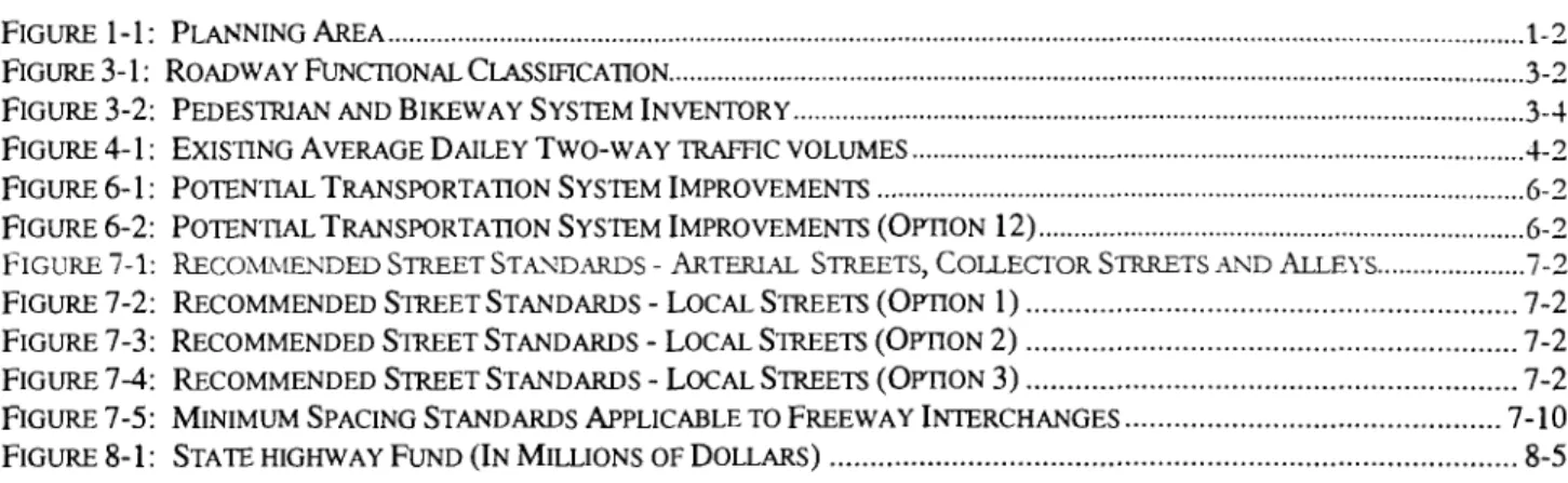
Average Daily Traffic
The Average Daily Traffic (ADT) on the Lexington-Echo Highway for 1996 is shown in Figure 4-1, along with the June 1998 ADT along Thielsen Road, just south of the 1-84 interchange.
Traffic volumes on the Lexington-Echo Highway increase from 590 vehicles per day (vpd) at the east city limits to a high of 1,100 vpd on Thielsen Street between Sprague and Bridge Streets, decreasing to 660 vpd at the west city limits. Average daily traffic growth, compounded annually since 1990, has ranged from approximately negative one percent immediately east of Front Street to zero percent immediately south of Main Street to a high of approximately four percent immediately east of Thielsen Street.
The traffic volumes shown on Figure 4-1 and other volume figures are average volumes for the year. Summer is the season when volumes are highest. ODOT data on area highways (US 730,I-82 and US 395 south of 1-84) indicate that during the summer season, volumes are about 20 to 30 percent higher than average volumes.
The June 1998 ADT volume along Thielsen Road, south of 1-84, reached 2,150 vpd, with a p.m. peak hour volume of 155 vph. No other daily or hourly traffic data were available for the city streets in Echo, nor were any counts taken. Because the 1996 daily volumes along the Lexington-Echo Highway and the June 1998 daily volume along Thielsen Road were so low, traffic volumes on the other city streets were expected to be much lower. The low level of traffic indicates capacity deficiencies on city streets are not an issue in Echo.
Street Capacity
Transportation engineers have established various standards for measuring traffic capacity of roadways or intersections. Each standard is associated with a particular level of service (LOS). In the 1991 OHP, levels of service were defined by a letter grade from A-F, with each grade representing a range of volume to capacity (v/c) ratios. A volume to capacity ratio (v/c) is the peak hour traffic volume on a highway divided by the maximum volume that the highway can handle. If traffic volume entering a highway section exceeds the section's capacity, then disruptions in traffic flow will occur, reducing the level of service. LOS A represents relatively free-flowing traffic and LOS F represents conditions where the street system is totally saturated with traffic and movement is very difficult. The 1999 OHP maintains a similar concept for measuring highway performance, but represents LOS by specific v/c ratios to improve clarity and ease of implementation. Table 4-1 presents the level of service criteria and associated range of v/c ratio for arterial and collector roadways.
TABLE 4-1
LEVEL OF SERVICE CRITERIA FOR ARTERIAL AND COLLECTOR STREETS
Service Level Typical Traffic Flow Conditions
C (0.60-0.69) C-D (0.70-0.73) D (0.74-0.83) D-E (0.84-0.87) E (0.84-0.97) E-F (0.98-0.99)
Relatively free flow of traffic with some stops at signalized or stop sign controlled intersections. Average speeds would be at least 30 miles per hour.
Stable traffic flow with slight delays at signalized or stop sign controlled intersections. Average speed would vary between 25 and 30 miles per hour.
Stable traffic flow with delays at signalized or stop sign controlled intersections. Delays are greater than at level B but still acceptable to the motorist. The average speeds would vary between 20 and 25 miles per hour.
Traffic flow would approach unstable operating conditions. Delays at signalized or stop sign controlled intersections would be tolerable and could include waiting through several signal cycles for some motorists. The average speed would vary between 15 and 20 miles per hour. Traffic flow would be unstable with congestion and intolerable delays to motorists. The average speed would be approximately 10 to 15 miles per hour.
Traffic flow would be forced and jammed with stop and go operating conditions and intolerable delays. The average speed would be less than 10 miles per hour.
Source: (1) Transportation Research Board, High19 Capado Manual, Special Report 209. National Research Counul, 1985. (2) ODOT, S I G W Users Manual. ODOT, 1994.
The 1999 Oregon Highway Plan (OHP) establishes mobility standards for the state highway system1. Regional Highways, such as Highway 82, should operate at a maximum volume to capacity ratio of 0.80 where the speed limit is less than 45 mph inside the urban growth boundary. For highways of district importance, such as Highway 350, the roadways should operate at a volume to capacity ratio of 0.85 where the speed limit is less than 45 mph.
Traffic operations were determined at one representative intersection along the Lexington-Echo Highway at Dupont Street using the 1985 Highway Capacity Software for unsignalized intersections. This software is based on the 1985 Highway Capacity Manual, Special Report 209, published by the Transportation Research Board. Since all intersecting streets and driveways are controlled by stop signs in the City, the analysis was performed for an unsignalized intersection. The peak hour traffic on the highway was assumed to be 10 percent of the 24-hour ADT volume and the directional split was assumed to be 60140. Because side street traffic volumes were unavailable, an assumed volume of 30 vph was used and unsignalized intersection level-of-service calculations were generated for the intersection. The peak hour operations at the intersections are shown in Table 4-2.
1999 Oregon Highway Plan, Table 6, MAXIMUM VOLUME TO CAPACITY RATIOS OUTSIDE METRO.
LEGEM): AR'IERUL URBAN G R O W BOUNDARY
---
O Rm m
LOCUSlREET 1OOO- 1996 AVERAGE DAILY TRAFFIC
/ 2,150'- 1998 AVERAGE DAILY 'IRAFRC
FIGURE 4-1
1
Existing Average
Daily
Two-way
Trac Volumes
-Echo
TABLE 4-2
SUMMARY OF OPERATIONS AT LEXINGTON-ECHO HIGHWAY
AND
DUPONT STREETIntersection Location Direction Movement 1996 LOS
Lexington-Echo Highway (E-W) & Dupont Street (N-S) Northbound Left, Through, Right A (<0.48)
southbound Left, Through, Right A (<0.48)
Eastbound Left A (<0.48)
Westbound Right A (<0.48) Note: The level of service is shown for all evaluated movements of the unsignalized intersection.
In general, the intersection of the Lexington-Echo Highway (Main Street) and Dupont Street currently operates very well based on the traffic volume assumptions made. Traffic volumes on both roadways are very low. Traffic on the highway, and at the minor street approaches on Dupont Street, flows smoothly at LOS A for all movements, which correlates to maximum volume to capacity ratio of less than .48.
Observing the June 1998 p.m. peak hour volumes along Thielsen Road indicates intersection operations are favorable (LOS A or vlc ratio <.48) for all intersecting minor streets along this road.
TRANSPORTATION DEMAND MANAGEMENT MEASURES
In addition to inventorying the transportation facilities in Echo, an inventory was performed of any Transportation Demand Management (TDM) strategies that may currently be in place. TDM strategies are designed to relieve congestion on the street system by spreading peak hour traffic over a longer period of time, encouraging the use of alternative modes of transportation (i.e. sidewalks, bike lanes, public transit), and encouraging the single car driver to ride with others through local carpool programs. Other than the sidewalk and bicycle facilities that exist in Echo, no formal TDM strategies exist in the City.
This following sections briefly describe two elements that may impact future transportation demand management decisions in the City: 1) distribution of departure time to work, and 2) distribution of travel modes.
Alternative Work Schedules
One way to maximize the use of the existing transportation system is to spread peak traffic demand over several hours instead of a single hour. Statistics from the 1990 Census show the spread of departure to work times over a 24-hour period (see Table 4-3). Approximately 27 percent of the total employees (those not working at home) depart for work between 7:00 and 8:00 a.m. Another 39 percent depart in either the hour before or the hour after the peak. Therefore, two-thirds of all morning commute trips occur between 6:00 a.m. and 9:00 a.m.
Echo Transportation System Plan June 2001
TABLE 4-3
DEPARTURE TO WORK DISTRIBUTION 1990 Census
Departure Time Trips Percent
12:OO a.m. to 459 a.m. 6 2.7%
5:00 a.m. to 559 a.m. 11 4.9%
6:00 a.m. to 659 a.m. 5 7 25.7%
7:00 a.m. to 759 a.m. 60 27.0%
8:00 a.m. to 859 a.m. 30 13.5%
9:00 a.m. to 959 a.m. 6 2.7%
10:OO a.m. to 1059 a.m. 9 4.1%
1 1:00 a.m. to 1 159 a.m. 2 0.9%
12:OO p.m. to 359 p.m. 29 13.1%
4:00 p.m. to 1 159 p.m. 12 5.4%
Total 222 100.0%
Source: US Bureau of Census.
Assuming an average nine-hour workday, the corresponding afternoon peak can be determined for work trips. Using this methodology, the peak work travel hour would occur between 4:00 and 5:00 p.m., which corresponds with the peak hour of activity measured for traffic volumes.
TRAVEL MODE DISTRIBUTION
Although the automobile is the primary mode of travel for most residents in the Echo area, some other modes are used as well. Modal split data is not available for all types of trips. The 1990 Census statistics that were reported for journey to work trips are shown in Table 4-4 and reflect the predominant use of the automobile in this area.
In 1990, 90.6 percent of all trips to work were in a private vehicle (auto, van, or truck). Trips in single- occupancy vehicles made-up 86.7 percent of these trips, and carpooling accounted for 13.3 percent.
The 1990 census data indicated that bicycles were not utilized for transportation. Since the census data do not include trips to school or other non-work activities, overall bicycle usage may be greater. None of the city of Echo roadways included dedicated bicycle lanes; however, there exists a short multi-use asphalt path connecting Thielsen and Buckley Streets. Dedicated bicycle lanes can encourage bicycle commuting, as can other facilities such as bicycle parking, showers, and locker facilities.
Pedestrian activity was also relatively high (6.7 percent of trips to work) in 1990. Statewide, 4.2 percent of trips to work were made on foot. Again, the census data only report trips to work; trips to school or other non-work activities are not included.
TABLE 4-4
JOURNEY TO WORK TRIPS 1990 Census
Trip Type Trips Percent
Private Vehicle 203 90.6% Drove Alone 176 86.7% Carpooled 27 13.3% Public Transportation 0 0% Motorcycle 0 0% Bicycle 0 0% Walk 15 6.7% Other 4 1.8% Work at Home 2 0.9% Total 224 100.0%
Source: US Bureau of Census.
ACCIDENT ANALYSIS
The Oregon Department of Transportation (ODOT) collects detailed accident information on an annual basis along the Lexington-Echo Highway within the Echo city limits. The accident information data show overall accident rates for the routes and accident locations. The accident rate for a stretch of roadway is typically calculated as the number of accidents per million vehicle miles traveled along that segment of roadway.
Historic
Table 4-5 shows the accident rates for the Lexington-Echo Highway in Echo as well as the Oregon statewide average for urban non-freeway secondary state highways from January 1, 1994 to December 3 1, 1996. The accident rate for the Highway during 1996 is nearly 30 percent higher than the statewide average for similar highways, indicating that a safety concern may exist. However, it should be noted that accident rate computations are sensitive to roadway segments with a relatively short length and low average daily traffic (ADT) volumes as in Echo. These characteristics support increased accident rates. No accident rate information was available for 1994 or 1995.
TABLE 4-5
HISTORIC ACCIDENT RATES FOR STATE HIGHWAYS (ACCIDENTS PER MILLION VEHICLE MILES TRAVELED)
Highway 1996 1995 1994
Lexington-Echo Highway in Echo 3.96 NA NA
Average for all Urban Non-freeway 3.10 3.27 2.79
Secondary State Highways
Echo Transportation System Plan June 2001
Table 4-6 contains detailed accident information on the Lexington-Echo Highway in Echo from January 1, 1994 to December 3 1, 1996. It shows the number of fatalities and injuries, property damage only accidents, v the total number of accidents, and the overall accident frequencies and rates for the segments of these roadways in Echo.
TABLE 4-6
ACCIDENT SUMMARY FOR LEXINGTON-ECHO HIGHWAY (JANUARY 1,1994 TO DECEMBER 3 1,1996)
Property Total Accident Accident Rate Location Fatalities Injuries Damage Accidents Frequency (acclmvm)
Only (acc/mily r)
MP 35.38 to MP 36.24 0 0 1 1 0.39 3.96
Source: Oregon Department of Transportation Accident Summary Database Investigative Report.
During the three-year period, there was a total of one accident within the Echo city limits, which was reported as resulting in property damage only. There were no fatalities or injuries on this roadway segment during the period. The accident occurred during daylight hours under dry pavement conditions. The driver error cited was an improper turning maneuver. There is no evidence to suggest that intersection operations (signals, signing, striping, etc.) were a contributing factor in the accident.
CHAPTER 5: TRAVEL FORECASTS
The traffic volume forecasts for Umatilla County and its municipalities are based on historic growth of the state highway system taking into account historic and projected population growth. Forecasts were only prepared for the state highway system in the county, since the volumes on these roadways are much higher than on any of the county roads.
LAND USE
Land use and population growth plays an important part in projecting future traffic volumes. Population forecasts were developed to help determine future transportation needs since the amount of growth and where it occurs will affect traffic and transportation facilities in the study area. The population analysis presented here is not intended to provide a complete economic forecast or housing analysis, and it should not be used for any purpose other than that for which it was designed.
The population projections for Umatilla County are based on historic growth rates, the original population and employment forecasts made by the State of Oregon Office of Economic Analysis (OEA), and a recent study
'
identifying new economicallydriven factors that will result in a higher population total than what was initially projected in the DEA forecast.Historic and projected population estimates for Umatilla County, Echo, and seven other cities in the county are summarized in Table 5-1. Factors that will affect the future growth rates of the county and incorporated cities include employment opportunities, available land area for development, and community efforts to manage growth.
TABLE 5-1
UMATILLA COUNTY POPULATION TRENDS
19701 1980' 1990' Estimate Projected Umatilla County 44,923 58,855 59,249 65,500 86,650 Incomorated Cities Echo 479 624 499 585 660 Adams Athena Helix Pilot Rock Stanfield Ukiah Sources:
1 ) Portland State University Center for Population Research and Census.
2) The population forecast shown for the county has been off~cially adopted, however there is no official breakdown in population for the incorporated cities in the county. The projected population numbers shown for the eight cities are based on the initial OEA forecast, solely for the purpose of producing travel forecasts for these cities.