Hungarian Association of Agricultural Informatics European Federation for Information Technology in Agriculture, Food and the Environment
Journal of Agricultural Informatics. Vol. 8, No. 2 journal.magisz.org
Developing an intelligent ICT system for environmentally optimized irrigation
management in agriculture
Syropoulou P.1, Symeonidou M.1, Tekes S.1, Wawer R.2, Kazantzidis A.3, Crnojevic V.4, Bruggeman
A.5
I N F O
Received 7 Mar. 2017 Accepted 7 Jun. 2017
Available on-line 14 Aug 2017 Responsible Editor: M. Herdon
Keywords:
Agricultiural irrigation, wireless sensor networks, WRF, DSS, ICT for agticulture
A B S T R A C T
Globally, agriculture makes use of 70% of all water withdrawn from aquifers, streams and lakes. Agriculture accounts for 22% of freshwater abstraction in Europe, outnumbered only by freshwater abstraction for cooling in energy production (45%). In the light of the real need to practically improve the environmental performance of irrigation systems and prevent the misuse of water, the ENORASIS project was established aimed to develop an intelligent, integrated Decision Support System (ENORASIS Service Platform and Components) for environmentally optimized and thus, sustainable irrigation management to be used by farmers and water management organizations. To achieve so, the ENORASIS project developed and integrated a bouquet of advanced technologies, methodologies and models in the fields of: (i) weather prediction systems that exploit satellite observations; (ii) irrigation optimization techniques and (iii) smart irrigation systems; and (iv) wireless sensor networks (functioning with solar energy) as key enabling technology for field measurements and monitoring conditions.
The system was tested in 5 pilot locations in Poland, Serbia, Cyprus and Turkey, providing large savings in water use as comparted to other irrigation practices while not compromising crop yields. The highest savings were observed in raspberry and potato plantations in Poland, reaching 90% and 59% respectively.
1. Introduction
Agriculture is an essential driving force in the management of water use (EEA, n.d.). In European Union, agricultural water demands vary depending on climatic conditions and its relevance to irrigation in agriculture. In southern Europe, however, agriculture uses more than half of the total national abstractions, rising to more than 80% in some countries (EEA, 2010). According to Aus der Beek et al. (2010), European water demand is higher in countries surrounding the Mediterranean Sea, especially Turkey, Spain, and Italy, which account for about 55% of the total irrigated land in Europe.
Agriculture wastes 60% or 1,500 trillion liters of the 2,500 trillion liters of water it uses each year, which represents the 70% of the planets accessible freshwater. One of the main culprits are the inefficient water irrigation systems (Stockle, 2001).
According to Stockle (2001), inappropriate management of water irrigation systems poses a huge burden to farmers and has a dramatic influence on the environmental impact of irrigated agriculture.
1 Syropoulou P.1, Symeonidou M.1, Tekes S.1
DRAXIS Environmental S.A., Mitropoleos 63, 54623, Thessaloniki, Greece 2 Wawer R.
The Institute of Soil Science and Plant Cultivaiton – State Research Institute, Czartoryskich 8, 24-100, Pulawy, Poland
3 Kazantzidis A .
University of Patras, University Campus-Rio , 26500, Patras, Greece 4 Crnojevic V.
Univerzitet U Novom Sadu Fakultet Tehnickih Nauka, TRG Dositeja Obradovica 25, 21000, Novi Sad, Serbia 5 Bruggeman A.
Inefficient irrigation systems can lead to exacerbation of the effects of salinity due to excess irrigation and poor drainage, disturbances of the underground aquifers, water pollution and soil degradation (ww.panda.org, n.d.). On the other hand, water management authorities face lack of a charging – billing system that responds to farmers’ needs, while charging procedures are time and money consuming, and inefficient in their application [WFD at www.ec.europa.eu, n.d.].
In this light, ENORASIS aims to develop an intelligent Decision Support System for environmentally optimized and, thus, sustainable irrigation management by farmers and water management organizations. The system will facilitate farmers to optimize the use of irrigation water, while it will provide water authorities intelligent tools to forecast and manage irrigation water resources, and charge farmers on a fair way.
In the following paragraphs, a more detailed description of the problem of inefficient irrigation is presented, followed by the elaboration of ENORASIS components, namely the Wireless Sensor Networks (WSN), the ENORASIS Meteorological Analysis Tool, the Irrigation Plan System, and the different system’s interfaces. Analysis and relevant simulation are provided for verification purposes, while conclusions make an evaluation of ENORASIS solution according to the verification results.
2. Related Work
In recent years, the application of ICT technologies in precision agriculture has attracted the interest of different stakeholders of the field. Various new ICT technologies have been developed, while several existing ones have been applied in precision irrigation management.
Regarding the deployment of Wireless Sensor Networks for measuring soil moisture, it is mainly performed either directly or via water balance calculations (Vellidis et al., 2007). The first approach, although easy to deploy, suffers from locality of measurements, whereas the real situation around the plant root is typically much more heterogeneous. This drives the need for sensor array that could successfully capture the variable soil moisture nature for the price of increased cost of the sensing part. In the second approach, the resulting measurements are not as accurate as direct soil moisture measurement methods. Besides the mainstream approaches described above, a number of other possibilities for soil moisture estimation are developed or are currently under investigation.
Satellite products useful for irrigation management also exist and concern the water cycle, and hydrology and meteorology disciplines. The LSA SAF (landsat.meteo.pl, n.d.) product provides daily snow coverage and evapotranspiration field over Europe, while EUMETSAT (www.eutemsat.int, n.d.) calculates the surface soil moisture index, wind and cloud information. Moreover, EUMETSAT provides rain rate in mm/h, and gives vertical profiles of air temperature, humidity and surface temperature.
Regarding GIS technologies – a basic component of the ENORASIS system – no specific application for irrigation management has been detected. However, there are several products related to precision agriculture which offer tools to monitor the water use in order to improve land / crop performance. Most GIS vendors offer complete software platforms that can be used in precision agriculture. For example ESRI (www.esri.com, n.d.) - one of the leading GIS vendor worldwide - offers the ArcGIS platform which includes ArcGIS Server for central geospatial data management and data distribution using web services, ArcGIS Desktop for data analysis and visualization, and ArcPAD for data capture in the field. Use of these software offers many tools for spatial analysis, modeling and visualization but requires high user expertise since these software are designed to serve general GIS needs. Similar GIS platforms are available from MapInfo (www.mapinfo.com, n.d.) or Intergraph (www.intergraph.com, n.d.).
precision agriculture) and advanced technologies in proximal remote sensing. Moreover, the SIRRIMED project (www.sirrimed.org, n.d.) addressed issues related to sustainable use of water in Mediterranean irrigated agricultural systems, with the overall aim of optimizing irrigation water use at farm, irrigation district and watershed scales.
However, in existing implemented systems information on weather is delivered by weather stations and predictions are based on historical data rather than prediction models using satellite images. This approach lacks in cost effectiveness and geographical coverage as it requires the installation of an adequate number of weather stations in the field in order to produce reliable data. ENORASIS will use Weather Research & Forecasting (WRF) prediction model - that for the purpose of the project - will be set up with multiple grids of different spatial resolution.
Moreover, although some relevant irrigation systems share partially common interest and objectives with those of ENORASIS, they either fail to incorporate the water management organization perspective at an operational level, or focus on models rather than integrated solutions with market uptake potentials. On the contrary, ENORASIS explores for the very first time the irrigation optimization issue across the whole value chain of irrigation, addressing the needs and motives of all stakeholders under a single and market applicable operational system.
3. The irrigation problem
As stated in the introduction, agriculture consumes the largest amount of water globally, accounting for the 70% of the total consumption (UN, 2003), while in most European countries the respective figures range between 30% and 60%. Specifically, irrigation is a significant environmental challenge as it is addressed in the EU Common Agricultural Policy (CAP) (CAP at ec.europa.eu, n.d.).
According to Dougherty and Hall (1995), irrigation schemes can pose various threats on the environment depending on the method adopted and the stage of implementation. Salinization, alkalization and soil acidification may result from the water and chemical leaching to the subsoil, while water resources may be depleted (www.icid.org, n.d.) due to the excessive inefficient irrigation. Local biodiversity and ecosystems may also be affected from the resulting environmental degradation (Daugherty and Hall, 1995).
Except from the abovementioned environmental stressors, farmers have to deal with the low levels of crop production which, in their turn, lead to additional use of irrigation water and increase the net water price (Stockle, 2001). Successively, farmers are facing enormous irrigation costs, and, being supported by no irrigation management tool, they may encounter the threat of cuts in their subsidies according to the regulations of the EU Cross Compliance Scheme (Cross Compliance at ec.europa.eu, n.d.).
Regarding irrigation water pricing, the EU Water Framework Directive (WFD at ec.europa.eu, n.d.) proposes that “adequate water pricing acts as an incentive for the sustainable use of water resources”, thus Member States should ensure that water charges reflect the true cost of the water demand. However, there is lack of a charging-billing system that aids water providers to respond to farmers’ needs (Cornish et al, 2004), something that may arise conflicts between providers and customers (farmers). All the above make difficult the forecast and management of irrigation water resources by the water providers, who may deviate from the regulations of the EU Water Framework Directive (“to promote sustainable water usage & environmental protection; mitigate the effects of floods & droughts”) (EU 200/60/EC, 2000).
4. The ENORASIS solution
optimization techniques and (iii) wireless sensor networks (functioning with solar energy) as key enabling technology for field measurements and monitoring conditions. Such an intelligent irrigation management and charging system is expected to have a major impact towards the adoption of more sustainable irrigation water management practices in agriculture and thus, increased environmental protection and costs savings for all stakeholders involved in agricultural economy.
4.1. Wireless Sensor Networks
Wireless Sensor Network (WSN) is a crucial part in precision agriculture and hence for the ENORASIS project. WSN is network of spatially distributed nodes that monitor environmental conditions and pass that data to remote central location. There is a lot of different WSN manufacturer and variety of products.
The ENORASIS is a WSN independent system which works with any Sensor Observation Service (SOS) compatible WSN. As a proof of concept the ENORASIS use two different types of WSN. One is “classic” multi hop network with several nodes and one main sink (base) which collects and send the data, made by Rainvent (www.reinvent.com, n.d.). Such a network is installed in Poland and Turkey. The second one is developed by BioSense Center – University of Novi Sad (www.biosensecenter.com, n.d.). It is a network of independent nods - every node sends the data separately using its own GPRS modem and that network is installed in Cyprus and Serbia.
Everything else is the same for both kind of WSN. They measure the soil moisture and the meteorological data (air temperature, air humidity, wind speed, precipitation etc.) and send them hourly to SOS server via middleware.
Middleware is server maintained by equipment manufacturer with its own database and/or GUI, which is capable to communicate with WSN in both directions. One direction is used to collect the measured data and the other to send the commands to the WSN to open/close valves in order to control entire irrigation process. The open/close commands and current valve status are sent/get using RESTful API HTTP methods. The digital flow meters are also part of the system so user can know the exact amount of water for irrigation. All collected data are sent to istSOS (www.sourceforge.net/projects/istsos/, n.d.) server using Python (www.pythin.org, n.d.) script.
In other to prolong the lifetime of WSN all actuator nodes (connected to valves) and nodes with GPRS modules are equipped with solar panels and bigger batteries. Using this approach on pilot sites all equipment runs for two years (project is still on-going) without any intervention.
4.2. ENORASIS Meteorological Analysis Tool
Accurate and reliable atmospheric ensemble forecasts are necessary for hydrologic predictions and risk-based management of water resources. Their utility in decision making in water management has been demonstrated in many studies during the last decade (Demargne et al, 2014).
In view of providing to the users with uncertainty-quantified forecasts, several atmospheric predictions centers make their ensemble weather forecasts available in the last two years. These ensembles consist of several perturbation forecasts covering the globe at coarse resolution; however, they are generally biased in the 1st and higher moments, unconditionally and conditionally on magnitude, season, storm type and other attributes (Buizza et al., 2005).
In the context of operational irrigation forecasting in ENORASIS, high resolution (2 km) ensemble meteorological simulations are produced over four selected pilot areas across Europe, spanning different climatological conditions and crops types. The implemented convection-allowing resolution does not require parameterizations, resulting in a better representation of the spatial and temporal statistical properties of convective precipitation than coarser models. In addition, higher resolution should lead to greater ensemble spread as smaller scales of motion are resolved (Clark and Gallus, 2009).
the forecast quality of many continuous variables of hydrologic importance (e.g. temperature, precipitation) at specific point locations across Europe. Once the statistical quality of the observed-forecasted sample will allow, the analysis will be conditioned on seasonality, magnitude and synoptic conditions. The ultimate goal of verification will be the development of a calibrated bias correction scheme for the raw forecasts.
Forecast verification and statistical calibration are necessary steps in meteorological ensembles. This continuous process requires a long dataset to adequately cover the whole distribution range of the predicted variables, including extreme events (Ebert et al., 2013). After the second year of data collection the WRF calibration was further improved. WRF was able to dynamically downscale global forecast data into finer resolutions in space and time for hydro-meteorological applications such as the irrigation management. Its skill was sensitive to the geographical location and physical configuration, driven by the variable relative importance of evapotranspiration and rainfall (Kioutsioukis et al., 2016).
4.3. Irrigation Plan System
Computer based Decision Support Systems in agriculture (aDSS) refers to applications or subsystems that helps farmers or advisors to make decisions in farm management based on data and models. aDSS can support tactical farm management (improving the sequencing or scheduling of resources to increase returns, reducing risk) or strategic farm management (deciding on the portfolio of enterprises undertaken) (Matthews et al., 2008). aDSS is typically a model, data and knowledge-driven DSS. For aDSS the emphasis is on support, since people make decisions and software at best only assists. aDSS is not about automated control. The systems element of aDSS (in contrast to the term decision support tools) recognises that aDSS is not only a stand-alone software tool but also data, knowledge and facilities to communicate or interpret the aDSS outputs.
Matthews et al. (2008) described aDSS history from phases of unbelief (late 1960s), euphoria and disappointment (in the 1970s), to phase of maturity with realistic expectations of the technology, or abandonment that began with web and mobile technology (beginning in the mid-1990s).
Looking on the agricultural practice, the use of agricultural DSSs by managers of farms or advisors is relatively low. One of the main reasons of that situation is that management practice of family farm is different than scientific approach (McCOwn, 2002). On the other hand, many of existed systems were created with not sufficient participation of potential users and they are not practical in use or there was not mutual understanding when aDSS can be used. Still scepticism is about the balance of costs and benefits in case of set up for needed to use aDSS for field sensors or weather data.
According to McCown (2002) the future of the DSS and related ISs holds promise in four directions:
• a “small” tool aiding farmers’ tactical decisions; • a versatile simulator as a consultant’s tool;
• a versatile simulator as the core of facilitated “learning laboratory”;
• a formal framework that supports regulatory objectives in constraining and documenting farming practice.
The DSS in terms of land irrigation is based upon several definitions:
Plot – basic areal unit of the farm derived through land zoning process, consisting of combination of soil and crop. Slope should be also considered as it shapes the soil water balance, generating superficial outflow and water loss.
User Database – contains properties of users: characteristics of irrigation plots (crop, soil, slope) within their farm as well as some general information on the zone and farm level, including economical info and irrigation system details.
DSS – calculates current plant water deficit (water stress) for particular plant phenological (development) stage for each land zone (uniform crop-soil conditions) basing upon measured soil moisture data while the expected water deficit for following days is calculated basing upon weather forecast. The deficit is necessary for the system in order to estimate the plant water demand that covers the current deficit in following day’s irrigation. The deficit is the physical information about the soil-plant-water conditions. To calculate the amount of water necessary to cover the demand using particular irrigation system a system-specific watering ratio should be used within DSS. Additionally economical consideration can be made. The output of the DSS is recommendations summarized into an Irrigation Plan for each Parcel with two options:
1. Minimalization of soil/plant water deficit
2. Optimization of farm yield/income
The plan may provide a summary information on the water demand for the whole farm. A DSS is designed to actually suggest solutions, not addressing the realization of the irrigation drivers and design.
The point of consideration are mobile irrigation systems, as the recommendations within the Irrigation Plan should take into consideration specific needs: time to move and set up the equipment, higher thresholds to perform irrigation, as it won’t be feasible to irrigate small amount of water with these systems.
The general idea of the DSS is based on assumption that actual meteorological data from closest meteorological station are adequate to real local data on the farm. Precipitation could vary essentially so we could suppose that effective precipitation assessed by comparison of soil moisture changes for neighboring days is better than the one from meteorological station.
4.4. System Interfaces
The ENORASIS application uses a restful API which exposes the most important functionalities and modules to the outer world via restful web services. Using this layer, any user/mechanism on the web can retrieve data or provide data to the ENORASIS platform suite though a secure mechanism based on BasicAuth. An additional purpose of this layer was to accommodate the request for a services oriented architecture (SOA), which exposes any of the subsystem information to the rest of the world once the platform is available on the web. All communication between the different parts that the application had to integrate with, were held through the API. In particular:
a) WRF – Daily a script calculates the WRF prediction and then holds an HTTP call to the ENORASIS server, in order to pass those values
b) Wireless Sensor Network – Almost every 5 minutes, various servers collecting data from the fields perform HTTP calls following the SOS standard, to update the ENORASIS server with the latest sensor measurements
c) Charging billing systems – Scripts that run daily communicate with the ENORASIS server via the rest API, to sync economic factors with popular ERP systems
Figure 1. The API is responsible for ENORASIS interfaces to the outside world
5. Simulation and Experimentation
The DSS system was designed to be able to compute irrigation plan even with absence of certain input data, e.g. missing soil moisture sensors, which can get destroyed or corrupted in the field.
The testing of the DSS systems was performed in two stages: testbed environment and real-live implementation on pilot sites.
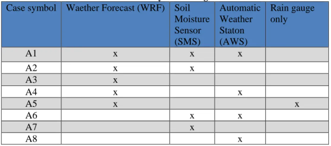
Testbed testing phase was based upon a Visual Basic code, run within MSExcell on two archive datasets: archive data form Pulawy region for time period 1970-2000; data recorded by ENORASIS system throughout 2013 season on pilot site in Poland. Testbed testing revealed several gaps and bugs. After necessary improvements of the code a detailed comparison of DSS behavior under different configurations of input data (Table 1) was tested.
Table 1. Cases for system testing scenarios
Case symbol Waether Forecast (WRF) Soil Moisture Sensor (SMS)
Automatic Weather Staton (AWS)
Rain gauge only
A1 x x x
A2 x x
A3 x
A4 x x
A5 x x
A6 x x
A7 x
A8 x
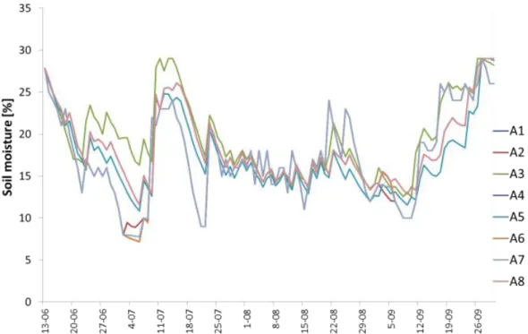
Figure 2. The distribution of soil moisture modelled with different system setups
Moreover, the results for potential evapotranspiration (Fig. 3) estimated with the use of automatic weather stations (scenario A8 plus A1, A4, A6) and WRF (A5 plus A2, A3) shown similar variability of evapotranspiration. However WRF estimations indicated in general lower amplitudes of changes than measured data.
Figure 3. Modelled ET0 for various system setups. (WRF-based, non-AWS scenarios: A2,A3,A5-blue)
crop types in three different climate regimes (North Central Poland, South Central Europe-Serbia and Mediterranean-Turkey and Cyprus) and within the context of three different operational settings / approaches (research farms, production farms and water management organisations).
Figure 4. Locations of ENORASIS pilot sites.
The results from pilot implementation of the fully operational system in 2014 show high savings in water in the cultivating of potato and raspberries in Poland as well as cotton in Turkey (table 2). Maize indicated savings on the level of 44 and 48 m3*Mg-1 (m3/t) of yield in Turkey and Poland respectively.
Table 2. Water consumption per unit yield (m3*Mg-1)
Specification Practise as usual (A) ENORASIS DSS (B) Difference (B-A)
m3*Mg-1 m3*Mg-1 m3*Mg-1 % A
POLAND
Maize 205,0 157,0 - 48 -23,4
Potato 71,1 29,5 - 41,6 -58,5
Early raspberry 140,5 14,0 - 126,5 -90,0
Late raspberry 310,2 215,0 - 95,2 -30,7
TURKEY
Maize 254,9 210,8 - 44,1 -17,3
Cotton 620,7 493,0 - 127,7 -20,6
SERBIA
Apple 17,2 13,1 - 4,0 -23,3
Cherry 90,8 71,4 - 19,4 -21,4
CYPRUS*
Grapefruit 220,7 205,3 - 15,4 -7,0
6. Conclusions
water, as well as water management organizations to forecast irrigation water resources, and charge fairly their customers (farmers).
The experiments aimed at testing the system performance and algorithms revealed savings in water use for irrigation achieved even during a relatively wet vegetation season (2014): starting from 7% for grapefruit in Cyprus to 90% in case of Early raspberry and 59% of potato in Poland. Low values for grapefruit in Cyprus may originate potentially from the Heisenberg’s rule as we could not prevent the farmer from being suggested by the system advise.
The ENORASIS platform is expected to have positive environmental, social, economic, as well as scientific and technological impact, as water management organizations and farmers will plan the water consumption of agricultural processes better, so as to ensure that irrigation needs will not exceed the capacity of water resources beyond safety levels.
7. Acknowledgment
The work was done under the framework of ENORASIS project (GA 282949) supported by European Commission under 7th Framework Program for Research in Environment.
References
Aus der Beek T., Flörke M., Lapola D.M., Schaldach R., Voß F., Teichert E. 2010 ‘Modelling historical and current irrigation water demand on the continental scale: Europe’. Advances in Geosciences, 27: 79-85.
https://doi.org/10.5194/adgeo-27-79-2010
Biosense Centre Website http://biosensecenter.com
Buizza R., Houtekamer P.L., Toth Z., Pellerin G., Wei M., Zhu Y. 2005 ‘A comparison of the ECMWF, MSC, and NCEP Global ensemble prediction systems’. Mon. Wea. Rev., 133, 1076–1097.
https://doi.org/10.1175/MWR2905.1
Clark A.J., Gallus W.A. 2009 ‘A Comparison of Precipitation Forecast Skill between Small Convection-Allowing and Large Convection-Parameterizing Ensembles’. Weather and Forecasting 24: 1121-1140.
https://doi.org/10.1175/2009WAF2222222.1
Common Agricultural Policy Website http://ec.europa.eu/agriculture/cap-post-2013/index_en.htm
Cornish G., Bosworth B., Perry C., Burke J. 2004 ‘Water charging in irrigated agriculture: an analysis of international experience’. FAO Water Reports 28, Rome.
Demargne J., Wu L., Regonda S.K., Brown J.D., Lee H., He M., Seo D.J., Hartman R., Herr H.D., Fresch M., Schaake J., Zhu Y. 2014 ‘The Science of NOAA's Operational Hydrologic Ensemble Forecast Service’, Bulletin of the American Meteorological Society, Vol. 95, Issue 1, 79-98. https://doi.org/10.1175/BAMS-D-12-00081.1 Dougherty T.C., Hall A.W. 1995 ‘Environmental impact assessment of irrigation and drainage projects. FAO Irrigation and Drainage’, Paper No. 53. FAO - Rome, Italy, pp. 73.
Ebert E., Wilson L., Weigel A., Mittermaier M., Nurmi P., Gill P., Göber M., Joslyn S., Brown B., Fowler T., Watkins A. 2013 ‚Progress and challenges in forecast verification’, Meteorological Applications, Volume 20, Issue 2, pages 130–139. https://doi.org/10.1002/met.1392
EEA. n.y. ‘IRENA Indicator Fact Sheet on Water Use Intensity-IRENA Indicator 10’. (http://www.eea.eu.int)
ESRI website on precision farming http://www.esri.com/industries/agriculture/business/precision-farming
EU Cross Compliance Website http://ec.europa.eu/agriculture/direct-support/cross-compliance/
EU Directive 2000/60/EC establishing a framework for Community action in the field of water policy. Retrieved from http://eur-lex.europa.eu/legal-content/EN/TXT/?uri=CELEX:32000L0060
EU Water Framework Directive Website http://ec.europa.eu/environment/water/water-framework/
European Environmental Agency (EEA) 2010 ‘Water resources: quantity and flows In: The European environment — state and outlook 2010, State of the environment report (SOER)’, EEA, Kopenhagen. http://www.eea.europa.eu/soer/europe/water-resources-quantity-and-flows
Hydrosense Website http://www.hydrosense.org/
ICID Website http://www.icid.org/res_irri_envimp.html
Intergraph Website http://www.intergraph.com/
Ioannis Kioutsioukis, Alexander de Meij, Hermann Jakobs, Eleni Katragkou, Jean-Francois Vinuesa, Andreas Kazantzidis, 2016 ‘High resolution WRF ensemble forecasting for irrigation: Multi-variable evaluation’, Atmospheric Research, Volume 167, Pages 156-174, ISSN 0169-8095,
(http://www.sciencedirect.com/science/article/pii/S0169809515002276 )
IstSOS Server Website http://sourceforge.net/projects/istsos/
Kioutsioukis I., Salamalikis A., Kotti M., Kazantzidis A. 2014 ‘Meteorological Ensemble Simulations for Hydrological Applications’, 12th International Conference on Meteorology, Climatology and Atmospheric Physics (COMECAP) Heraklion, 28 May – 31 May 2014, Greece.
Landsaf Website https://landsaf.meteo.pt/
Matthews K.B., Schwarz G., Buchan K., Rivington M., Miller D. 2008 ‘Wither agricultural DSS?’ Computers and electronics in agriculture 61, 149–159. https://doi.org/10.1016/j.compag.2007.11.001
McCown R.L. 2002 ‘Changing systems for supporting farmers’ decisions: problems, paradigms, and prospects’, Agricultural Systems 74 (2002) 179–220. https://doi.org/10.1016/S0308-521X(02)00026-4
OGC Website http://www.opengeospatial.org/standards/sos
PB Software Website http://www.pb.com/software/
Python Language Website https://www.python.org
Rainvent Website http://www.rainvent.com/English/index.html
Sirrimed Website http://www.sirrimed.org
Stockle C.O. 2001’ Environmental impact of irrigation: A review.’
http://www.home.stfrancoisgirlscollegett.com/attachments/230_IrrImpact2.pdf
UN WWD Report 2003
Vellidis G., Garrick V., Pocknee S., Perry C., Kvien C., Tucker M. 2007 ‘How wireless will change agriculture. Precision Agriculture’, 07 – Proceedings of the Sixth European Conference on Precision Agriculture (6ECPA), Skiathos, Greece, pp. 57-67.
Waterbee project Website http://waterbee.iris.cat/