Sharif University of Technology
Scientia IranicaTransactions B: Mechanical Engineering www.scientiairanica.com
GPS navigation solution using the iterative least
absolute deviation approach
D.-J. Jwo
a;, M.-H. Hsieh
band Y.-C. Lee
aa. Department of Communications, Navigation and Control Engineering, National Taiwan Ocean University, 2 Pei-Ning Rd., Keelung 202-24, Taiwan.
b. Domintech Co., Ltd., 31 Wugong 5th Rd., Wugu, New Taipei City 248, Taiwan. Received 22 May 2014; received in revised form 27 March 2015; accepted 2 June 2015
KEYWORDS Global Positioning System (GPS); Least absolute deviation; Multipath.
Abstract. The Least Squares (LS) approach has been widely used for solving GPS navigation problems. Despite its many superior properties, however, the LS estimate can be sensitive to outliers, and its performance, in terms of accuracy and statistical inferences, may be compromised when the errors are large and heterogeneous. The GPS signal is strongly aected by multipath propagation errors. The LS is not able to cope with the above condition to provide a useful and plausible solution. In this paper, an alternative approach, based on the Least Absolute Deviation (LAD) criterion, for estimating navigation solutions is carried out. As a robust estimator, the LAD estimator is known to approximately produce maximum-likelihood estimation. In this case, the maximum-likelihood estimator is obtained by minimizing the mean absolute deviation, rather than the mean square deviation, and, accordingly, can perform robust and eective estimations. Unlike the LS method, the LAD method is not as sensitive to outliers and, so, may provide more robust estimates. Therefore, the LAD method provides a useful and plausible navigation solution. Simulation results show that the method can eectively mitigate GPS multipath errors.
© 2015 Sharif University of Technology. All rights reserved.
1. Introduction
The Global Positioning System (GPS) [1-7] is a satellite-based navigation system that provides a user with the proper equipment access to useful and accu-rate positioning information anywhere on the globe. Determination of the coordinates of a receiver position from measurement of pseudo-ranges to satellites is the standard mode of positioning for users of the Global Positioning System and similar systems; a minimum of four pseudo-ranges is necessary for three-dimensional positioning. The equations linking the pseudo-ranges and the receiver coordinates are non-linear. The direct
*. Corresponding author. Tel.: +886-2-24622192, ext. 7209; Fax: +886-2-24633492
E-mail address: [email protected] (D.-J. Jwo)
solution of these non-linear equations is possible [5,7-10].
The most popular technique for solving linearised GPS pseudo-range equations for a receiver's position and clock bias is the L2(Least Squares, LS) scheme
[9-11]. The Least Squares (LS) method is one of the oldest and most widely used statistical tools for linear models. Its theoretical properties have been extensively studied and are fully understood. Despite its many superior properties, the LS estimate can be sensitive to outliers and, therefore, non-robust. Its performance, in terms of accuracy and statistical inferences, may be compro-mised when the errors are large and heterogeneous.
The traditional LS estimator is rather sensitive to large noises, resulting in large estimation errors. The reason for that is its Gaussian error assumption. When outliers occur, the LS estimation scheme may not be a
good choice because the LS estimator minimizes the mean squared error of the observations. In order to perform robust positioning estimation, other criteria rather than LS may be employed. The common alter-natives might be L1 (Least Absolute Deviation, LAD)
or L1 (minimax, MM) estimators [12,13]. The LAD
and MM estimators are known as two of the robust es-timators. The LAD estimator is also known to be able to produce approximately the maximum-likelihood es-timation. As compared to the LS method, the LAD method is less sensitive to outliers and produces robust estimates. In cases when the maximum-likelihood estimator is obtained by minimizing the mean absolute deviation, rather than the mean square deviation, it can perform robust and eective estimation. Even if the desired signals are corrupted by unknown errors, it tends to be impervious to unexpected large errors. Due to developments in theoretical and computational aspects, the LAD method has become increasingly pop-ular. In particular, it has many applications in econo-metrics and biomedical studies, among many others.
With the satellite navigation systems enhanced, many error sources are reduced. Multipath has become the dominant error source of code tracking. Multipath error is the code tracking loop error caused by the direct signals of the satellite and the reected signals in the vicinity of the receiver [14,15]. As the GPS signal is very weak indoors and in other harsh environments, the traditional receiver easily loses lock, resulting in reduced measurement accuracy. Strengthening the multipath estimation capability under weak signals has become the main objective in improving receiver performance.
This paper is organized as follows. In Section 2, a preliminary background on GPS measurement and linearized GPS pseudo-range equations is reviewed. The least squares and least absolute deviation methods are introduced in Section 3. In Section 4, simulation experiments on GPS navigation processing are carried out to evaluate the performance of the approach in comparison to that by LS. Conclusions are given in Section 5.
2. The GPS measurement and iterative approach for navigation solution
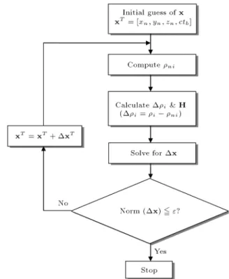
In order to do the positioning, pseudo-ranges between the receiver and the satellites are required. A typical approach is to use the iterative method. Because pseudo-range equation models are non-linear, iterative methods are natural choices in GPS positioning. How-ever, iterative methods have shortages of expensive computational overhead and a risk of non-convergence. Linearization is undertaken to convert the non-linear system of equations into an iterative procedure, which requires the solution of a linear system of equations
Figure 1. Denition of vectors.
in each iteration; i.e., the linear LS method is applied iteratively.
The GPS navigation solution determines the co-ordinates x = (x; y; z) of the GPS receiver and the receiver clock oset from measurements of at least four pseudo-ranges. Consider the vectors depicted in Figure 1 relating to the centre of the Earth, satellites and user position. The vector, s, represents the vector from the Earth's centre to a satellite, u represents the vector from the Earth's centre to the user's position, and r represents the vector from the user to the satellite; we can write the vector relation as:
r = s u: (1)
Distance, krk, is computed by measuring the prop-agation time from the transmitting satellite to the user/receiver. The pseudo-range, i, is dened for the
ith satellite by:
i = ksi uk + ctb+ vi; (2)
where c is the speed of light and tbis the receiver clock
oset from the system time, and viis the pseudo-range
measurement noise. Considering the user position in three dimensions, denoted by (xu; yu; zu), the GPS
pseudo-range measurements made to the n satellites can then be written as:
i=
p
(xi xu)2+(yi yu)2+(zi zu)2+ctb+vi;
i = 1; ; n; (3) where (xi; yi; zi) denotes the ith satellite's position in
three dimensions.
The states and measurements are related non-linearly; the nonlinear ranges are linearized around an operating point using Taylor's series. Eq. (3) can be linearized by expanding Taylor's series around the approximate (or nominal) user position, (^xn; ^yn; ^zn),
and neglecting the higher terms. Dening ^i as i at
(^xn; ^yn; ^zn) gives:
i=i ^i= ei1xu+ ei2yu+ ei3zu+ ctb
where: ei1=^xn^r xi
i ; ei2=
^yn yi
^ri ; ei3=
^zn zi
^ri ;
^ri=
p
(^xn xi)2+ (^yn yi)2+ (^zn zi)2: (5)
Vector (ei1; ei2; ei3) Ei, i = 1; ; n, denotes the
line-of-sight vector from the user to the satellites. Eq. (4) can be written in a matrix formulation:
i=1 2 3 nT
= 2 6 6 6 6 6 4
e11 e12 e13 1
e21 e22 e23 1
e31 e32 e33 1
... ... ... ... en1 en2 en3 1
3 7 7 7 7 7 5 2 6 6 4 xu yu zu ctb 3 7 7
5 + vi; (6)
which can be represented as:
= Hx + v: (7)
The dimension of matrix H is n 4, with n 4, and H is usually referred to as the `geometry matrix' or `visibility matrix'.
The LS approach has been widely used for solving GPS navigation states. The most commonly used algorithm for position computation from pseudo-ranges is the non-linear LS method. In some environments, the GPS signal is strongly aected by multipath prop-agation. Its performance, in terms of accuracy and statistical inferences, may be compromised when the errors are large and heterogeneous. The LS is not able to cope in the above condition, and it provides a useful and plausible solution. Therefore, the LAD approach is employed as a new trial. Figure 2 provides the iterative method for solving GPS navigation problems.
3. The least squares and least absolute deviation methods
3.1. Least squares approach
Given a set of equations, y = Hx, we attempt to seek the x vector that has the minimum mean square error. Since:
HTHx = HTy;
we need to show that HTH is nonsingular, so that x
can be solved. If H is an m n matrix of rank, n, then HTH is nonsingular. To show that the null space of
HTH is zero, multiplying both sides by xT, we have:
0 = HTHx = (Hx)THx = kHxk2:
If the magnitude of a vector is zero, then, the vector is zero, Hx = 0. Since:
rank(H) = n;
we conclude that x = 0. Hence, the least squares
Figure 2. Iterative method for solving the GPS navigation solutions.
solution to Eq. (7) is given by:
x = (HTH) 1HTy: (8)
3.2. Least absolute deviation approach
The LAD estimation approach is an iterative algorithm adopted from [13]. Once LAD estimation is justied, and its edge over the LS estimation (in an appropriate condition) is established, an ecient algorithm to obtain LAD estimates has practical signicance. The improved algorithm for L1estimation is very similar to
iterative weighted least squares, summarized as follows. Given a linear model y = Hx + ":
Step I: Obtain the LS estimates of ^x, ^y, and ^" using: ^x = (HTH) 1HTy;
_y = H^x;
^" = y ^y:
Step II: Compute the weight in the computation: ^
Wij = j^"1
ij for i = j;
else: ^
Wij = 0; i; j = 1; 2; ; n:
Step III: Obtain the LAD estimates of ^x, ^y and ^" using:
^x = (HTWH)^ 1HTWy;^ (9a)
^y = H^x; (9b) ^" = y ^y: (9c)
Step IV: If convergence has been reached to the pre-assigned accuracy, i.e. the values of ^x have been stable, then, terminate the iteration, otherwise, go to Step II.
4. Results and discussion
Simulation tests have been carried out for conrmation of the eectiveness and justication of the performance. Simulation was conducted using a personal computer. The computer codes were developed by the authors using Matlab® software. The commercial software
Satellite Navigation (SATNAV) toolbox by GPSoft LLC was employed for generating the satellite posi-tions and pseudo-ranges. Generation of the multipath signals is necessary for the simulation. In this paper, the pseudo-range multipath error is created using the Matlab function `mpgen' in the Satellite Navigation toolbox (SATNAV) toolbox [16]. The function mpgen creates a multipath by passing white noise through a rst-order Butterworth low-pass lter. In many applications, the multipath is well-modelled by this kind of simple colored noise. See [16] for further detailed information.
Several tests have been carried out to evaluate the performance. In this paper, the numbers of the satellites in view are 8 and 6, respectively. Further-more, the numbers of satellite signals corrupted by the multipath include 1, 2, and 3, respectively. The carrier-to-noise ratio, C=N0's, of the GPS, with good signal
power, typically ranges from 35-55 dB-Hz, where the carrier-to-noise ratio is:
c=n0= (SNR)(BL) (ratio-Hz);
C=N0= 10 log10(c=n0) (dB-Hz):
The total time of simulation is 152 seconds. In three time intervals, 20-30, 80-90, and 140-150 sec, severe multipath signals are generated. In the three time intervals, C=N0is simulated to decrease from the range
of 35dB-Hz and above to 20 dB-Hz.
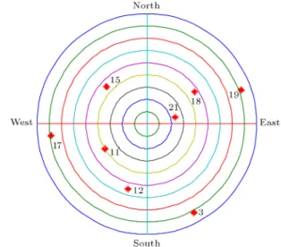
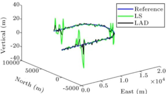
Two sets of results based on numerical experi-ments are provided. The rst set of results involves the case of 8 satellites in view; the second set of results involves the case of 6 satellites in view. Figure 3 shows the skyplot when 8 satellites are in view. Figure 4 shows the three dimensional plot of a reference tra-jectory, with positioning solutions based on the LAD approach, as compared to the LS approach, when 1 satellite signal is corrupted by multipath. Figure 5
Figure 3. Skyplot for the case of 8 satellites in view.
Figure 4. Positioning solutions for LAD and LS approaches; 8 satellites in view with 1 satellite signal corrupted by multipath.
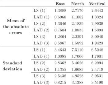
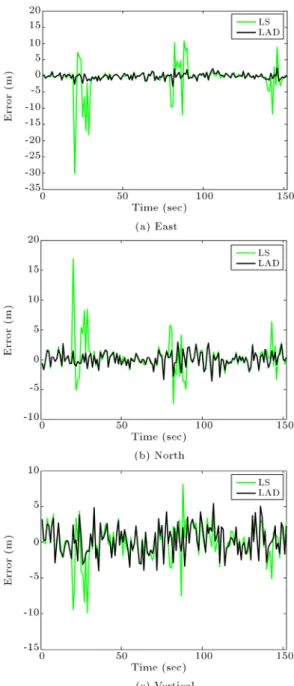
provides comparison of position errors in the east, north, and vertical components. When there are 2 satellite signals corrupted by multipath eects, the results are shown in Figures 6 and 7. Figure 6 provides a three-dimensional plot of the reference trajectory with positioning solutions for LAD and LS approaches. Figure 6 gives comparison of position errors in the east, north, and vertical components for LAD and LS approaches. When there are 3 multipath-corrupted satellite signals, the results are shown as in Figures 8 and 9. Figure 8 shows the three-dimensional plot of the reference trajectory with positioning solutions for LAD and LS approaches when 3 satellite signals are corrupted by multipath. Figure 9 provides the compar-ison of position errors for LAD and LS approaches. The statistic of the errors for the LS and LAD approaches, when 8 satellites are in view, is summarized in Table 1. The number in the bracket indicates the number of satellite signals corrupted by multipath.
Further study is performed when there are only 6 satellites in use for which the skyplot is shown in Figure 10. The results are shown in Figures 11-16.
Figure 5. Comparison of position errors for LAD and LS approaches; 8 satellites in view with 1 satellite signal corrupted by multipath.
Figure 6. Positioning solutions for LAD and LS approaches; 8 satellites in view with 2 satellite signals corrupted by multipath.
Figure 7. Comparison of position errors for LAD and LS approaches; 8 satellites in view with 2 satellite signals corrupted by multipath.
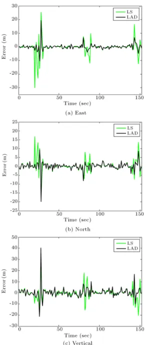
Figure 8. Positioning solutions for LAD and LS approaches; 8 satellites in view with 3 satellite signals corrupted by multipath.
Figure 9. Comparison of position errors for LAD and LS approaches; 8 satellites in view with 3 satellite signals corrupted by multipath.
Figure 11 shows the positioning solutions based on the LAD approach, as compared to the LS approach, when 1 satellite signal is corrupted by multipath. Figure 12 provides a comparison of position errors in the east, north, and vertical components. When there are 2 satellite signals corrupted by multipath eects, the results are shown as in Figures 13 and 14. Figure 13 provides the positioning solutions for LAD and LS approaches. Figure 14 gives comparison of position errors in the east, north, and vertical components for LAD and LS approaches. When there are 3 satellite signals corrupted, the results are shown in Figures 15 and 16. Figure 15 gives the positioning solutions
Table 1. Statistic of errors for the two approaches (in meters); 8 satellites in view. The number in the bracket indicates the number of satellite signals corrupted by multipath.
East North Vertical
Mean of the absolute
errors
LS (1) 1.3888 2.7170 2.6442 LAD (1) 0.6960 1.1082 1.3324 LS (2) 1.3646 2.1839 2.9939 LAD (2) 0.7604 1.0835 1.5093 LS (3) 1.2864 2.2294 3.0940 LAD (3) 0.5867 1.5892 1.9423
Standard deviation
LS (1) 3.4643 7.5110 6.5048 LAD (1) 1.0085 1.7066 1.7901 LS (2) 2.8362 5.4626 6.2994 LAD (2) 1.1355 1.6683 2.4719 LS (3) 2.5438 4.9528 5.9531 LAD (3) 0.8215 3.1388 3.5190 Table 2. Statistic of errors for the two approaches (in meters); 6 satellites in view. The number in the bracket indicates the number of satellite signals corrupted by multipath.
East North Vertical
Mean of the absolute
errors
LS (1) 2.0247 1.5815 2.0063 LAD (1) 0.6906 0.9162 1.6829 LS (2) 2.1345 1.9530 3.0688 LAD (2) 1.1245 1.3319 2.5160 LS (3) 2.2988 1.9952 3.0577 LAD (3) 1.3192 1.5684 2.8044
Standard deviation
LS (1) 4.5437 2.5905 2.6653 LAD (1) 0.9036 1.1893 2.0853 LS (2) 5.0883 3.5337 5.1759 LAD (2) 2.2838 2.4361 4.8498 LS (3) 5.7114 3.8056 5.3943 LAD (3) 2.5970 2.6550 4.7434
for LAD and LS approaches when 3 satellite signals are corrupted by multipath. Furthermore, Figure 16 provides a comparison of position errors for LAD and LS approaches. The statistic of the errors for the two approaches for the case of 6 satellites in view is summarized in Table 2.
It can be seen that the LAD approach demon-strates a much better multipath resistance capability compared to the LS method. For GPS signals in harsh multipath environments, the navigation solution based on the LAD approach possesses a remarkable performance improvement. For the LAD approach, some of the conditions assumed for the main results may be dropped and, in particular, the errors may not have to follow the same distribution. In contrast, the
Figure 10. Skyplot for the case of 6 satellites in view.
Figure 11. Positioning solutions for LAD and LS approaches; 6 satellites in view with 1 satellite signal corrupted by multipath.
LS method generally requires that the errors follow the same normal distribution. The current results show that the results by LAD demonstrate a better multipath mitigation capability than those by LS when there are less than 3 satellite signals corrupted by the multipath eect. The LAD approach possesses more benets when more satellites are in view and/or less satellite signals are corrupted by multipath. This is due to the fact that a larger number of multipath-corrupted signals will mislead the correct information, resulting in performance degradation. For example, for the case of 6 satellites in view, if more than 3 signals are corrupted, the LAD approach does not show remarkable improvement, as shown in Figure 16. In this illustrated example, there are 6 satellites available, in which 3 satellites are corrupted by multipath. This means that up to 50% of the satellite signals in use are multipath-corrupted.
As just mentioned, LAD performance is depen-dent on the number of satellites in use and the number of multipath-corrupted signals. For this example, the LAD seems not to get much performance improvement in the vertical component. However, it should be noted
Figure 12. Comparison of position errors for LAD and LS approaches; 6 satellites in view with 1 satellite signal corrupted by multipath.
Figure 13. Positioning solutions for LAD and LS approaches; 6 satellites in view with 2 satellite signals corrupted by multipath.
Figure 14. Comparison of position errors for LAD and LS approaches; 6 satellites in view with 2 satellite signals corrupted by multipath.
Figure 15. Positioning solutions for LAD and LS approaches; 6 satellites in view with 3 satellite signals corrupted by multipath.
Figure 16. Comparison of position errors for LAD and LS approaches; 6 satellites in view with 3 satellite signals corrupted by multipath.
that this is not always the case since the positioning results are closely related to the satellite-user geometry. The performance degradation appearing in certain coordinate components will be time varying, depending on the satellite constellation at that time.
5. Conclusions
Mitigation of multipath errors using the least absolute deviation approach is presented in this paper. For the GPS signal in harsh multipath environments, the LAD approach possesses a better navigational performance compared to the LS approach for estimating naviga-tional solutions. Compared to the LS method, the LAD
method is less sensitive to outliers and demonstrates a better multipath mitigation capability. However, current results show that for cases when more than 3 signals are corrupted, the LAD approach does not possess such benets. Further investigation will be conducted for cases where more than 3 satellite signals are corrupted by multipath errors.
Acknowledgment
This work has been supported by the Ministry of Science and Technology, the Republic of China un-der grant numbers NSC 101-2221-E-019-027-MY3 and MOST 104-2221-E-019-026-MY2.
References
1. Axelrad, P. and Brown, R.G. \GPS navigation
algo-rithms", In Global Positioning System: Theory and Applications, B.W. Parkinson, J.J. Spilker, P. Axelrad and P. Enga, Ed., I, AIAA, Washington DC, Chap. 9 (1996).
2. Bancroft, S. \An algebraic solution of the GPS
equa-tions", IEEE Trans. Aero. Electro Systems, AES-21(7), pp. 56-59 (1985).
3. Jwo, D.-J. \GPS navigation solutions by analogue
neural network least-squares processors", Journal of Navigation, 58(1), pp. 105-118 (2005).
4. Farrell, J. and Barth, M., The Global Positioning
System and Inertial Navigation, McGraw-Hill (1999).
5. Kleusberg, A., Analytical GPS Navigation Solution, in
E.W. Grafarend et al., Eds., Geodesy-The Challenge of the 3rd Millennium Springer-Verlag Berlin Heidelberg, pp. 93-96 (2003).
6. Faghri, A., Hamad, K. and Duross, M. \Application of
GIS and GPS for collecting and analyzing travel time, speed and delay", Scientia Iranica, 10(2), pp. 153-163 (2003).
7. He, Y. and Bilgic, A. \Iterative least squares method
for global positioning system", Advances in Radio Science, 9, pp. 203-208 (2011).
8. Krause, L.O. \A direct solution to GPS-type
naviga-tion equanaviga-tions", IEEE Trans. Aero. Electro Systems, AES-23(2), pp. 225-232 (1987).
9. Lundberg, J.B. \Alternative algorithms for the GPS
static positioning solution", Applied Mathematics and Computation, 119, pp. 21-34 (2001).
10. Yalagadda, R., Ali, I., Al-Dhahir, N. and Hershey, J.
\GPS GDOP metric", IEE Proc.-Radar, Sonar Navig., 147(5), pp. 259-264 (2000).
11. Rahmani Firoozjaee, A. and Afshar, M.H. \Discrete
least squares meshless (DLSM) method for simulation of steady state shallow water ows", Scientia Iranica, Transactions A: Civil Engineering, 18(4), pp. 835-845 (2011).
12. Chen, K., Ying, Z., Zhang, H. and Zhao, L. \Analysis
of least absolute deviation", Biometrika, 95(1), pp. 107-122 (2008).
13. Dasgupta, M. and Mishra, S.K. \Least absolute
de-viation estimation of linear econometric models, A literature review", MPRA paper 1781, North-Eastern Hill University (2004).
14. Iltis, R.A. and Hanson, G.A. \Joint estimation of PN
code delay and multipath using the extended Kalman lter", IEEE Trans. Commu., 38, pp. 292-299 (1990).
15. Yuan, G., Xie, Y., Song, Y. and Liang, H. \Multipath
parameters estimation of weak GPS signal based on new colored noise unscented Kalman lter", Proceed-ings of the 2010 IEEE International Conference on Information and Automation, June 20-23, Harbin, China, pp. 1852-1856 (2010).
16. GPSoft LLC 2003 Satellite Navigation (SatNav)
Tool-Box 3.0 User's guide.
Biographies
Dah-Jing Jwo was born in Taiwan, in February 1964. He received a PhD degree in Aerospace En-gineering from the University of Texas at Arlington, in 1995. From 1997 to 1998, he worked in industry and at the Center for Aviation & Space Technology in the Industrial Technology Research Institute (ITRI), Hsinchu, Taiwan. In 1998, he joined the faculty of the National Taiwan Ocean University, where he is currently Professor with the Department of Commu-nications, Navigation and Control Engineering. His scientic interests include GPS navigation, multisensor integrated navigation, estimation theory and appli-cations, articial intelligence, and vehicle guidance, Navigation and Control (GN&C) design. Dr. Jwo is also a member of the Editorial Board of a number of international journals, including GPS Solutions, the Journal of Navigation, and the Journal of Marine Science and Technology.
Meng-Hsien Hsieh was born in Taiwan, in March 1989. He received a BS degree in Electrical Engineering from the National Kaohsiung University of Applied Sci-ences, Kaohsiung, in 2011, and an MS degree in Com-munications, Navigation and Control Engineering from the National Taiwan Ocean University, Keelung, Tai-wan, in 2013. His research interests include GPS nav-igation and multisensor integrated navnav-igation design. Yu-Chuan Lee was born in Taiwan, in November 1991. He received a BS degree in Communications, Navigation and Control Engineering from the National Taiwan Ocean University, Keelung, in 2014. His research interests include GPS navigation, nonlinear estimation theory and applications, and digital signal processing.