THE DISTRIBUTED HOUSEHOLD:
PLANT AND MOLLUSK REMAINS FROM K’AXOB, BELIZE
Maia Dedrick
A thesis submitted to the faculty of the University of North Carolina at Chapel Hill in partial fulfillment of the requirements for the degree of Master of Arts in the Department of
Anthropology.
Chapel Hill 2013
Approved by:
ABSTRACT
MAIA DEDRICK: The Distributed Household: Plant and Mollusk Data from K’axob, Belize (Under the direction of Patricia A. McAnany and C. Margaret Scarry)
In the archaeological study of ancient Maya sites, scholars have considered structures of various sizes and configurations the material remains of households, social groups that made up the basic units of economic production. Archaeologists have used disparities in structure size and complexity to argue for political and ritual hierarchy among structures. This study presents faunal and botanical data from two structures at the site of K’axob, in northern Belize, which have been referred to as adjacent households. Using this biological as well as architectural evidence, I explore the relationship between the larger and smaller structure and developments in the organization of activity areas through time. I suggest that, by the Classic period, households were distributed across more than one structure.
ACKNOWLEDGEMENTS
This thesis was made possible thanks to a great deal of flotation conducted by Professor McAnany and her 1995 K’axob field season team members. I am grateful that she decided to keep the samples around until I got to them. Also, I thank Professor Scarry for letting me use her lab equipment and for a great deal of assistance with seed identification, imaging, and comparative samples. My research was enhanced by trips to paleoethnobotany laboratories with strong Mesoamerican botanical comparative collections. These include the labs at Georgia State University, run by Dr. Christopher Morehart at the time of my visit, and at the University of Cincinnati, directed by Dr. David Lentz. I thank these scholars for
providing me with lab space, equipment, access to collections, and good advice during my research trips. My dedicated committee members provided useful suggestions and patiently guided me as I navigated the formation of my first major laboratory-based research
TABLE OF CONTENTS
LIST OF TABLES ... viii
LIST OF FIGURES ... ix
CHAPTER 1: INTRODUCTION ... 1
CHAPTER 2: MAYA SOCIAL GROUPS AND IDENTITIES ... 7
Issues in Hierarchy ... 7
Personhood and Dwelling(s) ... 12
Defining Households and Other Social Groups ... 15
CHAPTER 3: ENVIRONMENTAL AND ARCHAEOLOGICAL CONTEXTS ... 22
Environment of K’axob ... 23
Prior Research at K’axob ... 26
Operation 14 ... 33
Operation 15 ... 38
Botanical Samples ... 41
CHAPTER 4: PLANT AND ANIMAL USE IN ANCIENT NORTHERN BELIZE ... 44
Faunal Remains ... 44
Botanical Remains ... 48
Formative Period ... 48
Caves, Ritual, and Status in the Classic Period ... 52
CHAPTER 5: CONTEXTUALIZED MOLLUSK AND PLANT INFORMATION ... 57
The Apple Snail Shells from Operations 14 and 15 ... 57
Patterns in Plant Remains from K’axob, Operations 14 and 15 ... 61
Late Formative and Protoclassic Periods (Late K’atabche’k’ax Complex) ... 63
Early Classic Period (Late Nohalk’ax Complex) ... 67
Late Classic and Terminal Classic Periods (Witsk’ax Complex) ... 68
Intrusive or Naturally Occurring Species ... 72
Spatial Distribution of Plant Remains ... 74
CHAPTER 6: THE DISTRIBUTED HOUSEHOLD ... 78
Formative Period: Ritual and Diet ... 78
Classic Period: Household Organization and Intrasite Dynamics ... 82
Synthesis of Burial Data from Northern K’axob ... 89
Reconsidering Isotopic Evidence ... 91
Ceramic Evidence ... 93
CHAPTER 7: COMPARATIVE DISCUSSION ... 94
Excavation of Residential Structures within Small Sites ... 95
Chan ... 96
Cerén ... 103
Surveys of Northern Belize ... 106
San Estevan ... 107
Cuello ... 111
Population Estimates ... 113
CHAPTER 8: CONCLUSION ... 116
APPENDIX ... 119
LIST OF TABLES
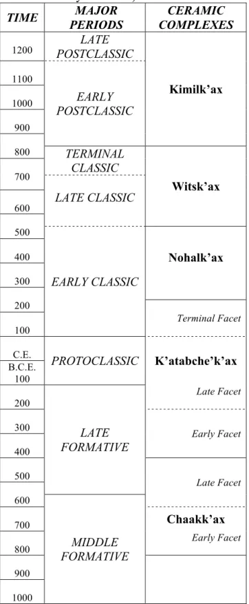
Table 1. Ceramic complexes of K’axob aligned with major chronological periods ... 29 Table 2. Flotation samples from Operations 14 and 15 in order by
zone, indicating phase, context, unique sample number, and
wood weight ... 42 Table 3. Plants from which charred seeds were found within K’axob
samples, organized by function or habitat ... 62 Table 4. Plant taxa found within richest contexts at Operations 14 and 15 ... 65 Table 5. Counts of carbonized seeds and maize cupules found
LIST OF FIGURES
Figure 1. Map of the Maya area showing the location of K’axob in relation to other sites in northern Belize (courtesy of Patricia A.
McAnany). ... 10
Figure 2. Map of northern Belize with an emphasis on the sites immediately neighboring K’axob (from McAnany 1992:199) ... 11
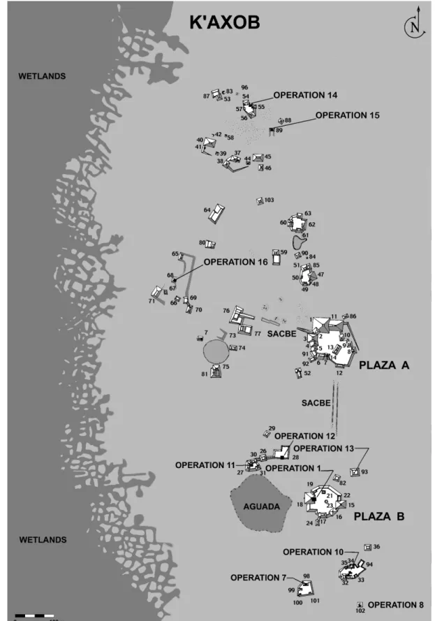
Figure 3. Map of K’axob excavations, with Operations 14 and 15 in the northern portion of the site (courtesy of Patricia A. McAnany) ... 28
Figure 4. Operation 14, Construction Phase II (from Schulz 1997:21) ... 34
Figure 5. Operation 14, Construction Phase VIb (from Schulz 1997:32) ... 36
Figure 6. Operation 14, Construction Phase VII (from Schulz 1997:35) ... 37
Figure 7. Operation 15, Construction Phase I (from Berry 1997:46) ... 39
Figure 8. Operation 15, Construction Phase II (from Berry 1997:56). ... 40
Figure 9. Miniature flask from Operation 16, Zone 8, found during the 1995 K’axob field season (from Terranova et al. 1996). ... 53
Figure 10. Drawings of apple snail (Pomacea sp.) shells, with (A) valve length, and (B) operculum length indicated. Illustrations by Astrid Runggaldier (from Eckhardt 1995:3) ... 58
Figure 11A – 11D. Histograms of apple snail (A) valve length from Operation 14; (B) operculum length from Operation 14; (C) valve length from Operation 15; and (D) operculum length from Operation 15 (data from Eckhardt 1995) ... 59
Figure 12. Image of cheno-am from Operation 14 midden using Scanning Electron Microscope. ... 64
Figure 13. Examples of thoroughly carbonized cheno-am seeds from Operation 14 midden ... 64
Figure 14. Fiber fragment from Operation 14 midden ... 66
Figure 16. Tobacco seed from Operation 14, Hearth 2, indicating
identification criteria ... 70
Figure 17A-17B. Seeds from the grape family (Vitaceae): (A) Cissus verticillata, and (B) Vitis tiliifolia ... 71
Figure 18. Ubiquity (out of 14 total contexts) of the main paleoethnobotanical finds from K’axob, omitting those that appear to have entered the record naturally ... 75
Figure 19. The Northeast Group from Chan (from Blackmore 2011:165) ... 97
Figure 20. Map of Chan Nòohol (from Robin 2002:251) ... 101
CHAPTER 1: INTRODUCTION
By the Late Classic period (550-850 CE), settlements of all sizes dotted the highly populated landscape of northern Belize. In urban centers and smaller towns people of different social status lived side-by-side. Various combinations of tribute, taxation, and reciprocity between and within communities figured into the complicated web of
relationships that made up economic, social, and ritual identities (McAnany 2010:135). Elites materialized and maintained their authority through monumental architecture, ritual
performances, and inherited and acquired luxury goods (McAnany 2010:159). Elites also forged their identities in part through the consumption of preferred foods that signified inherited wealth, ritual power, and political access. Widespread divisions in diet based on status have been identified using isotopic, paleoethnobotanical, and faunal evidence (Emery 2003; Lentz 1991; Metcalfe et al. 2009; Somerville et al. 2012). These studies have focused to a great extent on large, royal centers.
In recent decades archaeologists working in the Maya area have increasingly focused on non-royal and nonurban residential areas. Resulting studies have emphasized the
the other hand, plant and animal use differed within and between communities depending on social, environmental, economic, and ritual factors.
Previously, scholars have tried to understand regional and intrasite social and economic organization through the study of settlement patterns (Levi 1996, 2003; Lohse 2004). Research into site layout in northern Belize and elsewhere has illustrated the variety of structures present within non-urban sites. They range from compounds that shared basal platforms with courtyards and pyramidal eastern shrine structures, to “isolates,” buildings without platforms some distance from other structures. Nearly all of these varied
In this thesis I use food-related data to explore the concept of intrasite hierarchy as it relates to the site of K’axob, located adjacent to Pulltrouser Swamp in northern Belize (Figure 1). Patricia McAnany directed excavations at K’axob from 1990-1998 (McAnany 1993, 1995, 1997, 2004; McAnany and Berry 1999). As part of the project, Hope Henderson (2003) investigated intrasite hierarchy at K’axob through stable isotope signatures of burials interred within different types of structures. Assuming that each platform equaled the space of a household, she argued that people buried in larger and more complex platform groups would have had the opportunity to pursue a wider variety of subsistence strategies and thus consumed less maize (Zea mays) compared to people from smaller households. This suggestion is at odds with evidence that maize was consumed as a status food across the Maya area at this time (Coyston et al. 1999; Reed 1994; White et al. 1993; White,
Pendergast, et al. 2001). However, northern Belize is a region in which maize seems to have been less associated with status than elsewhere, as overall maize consumption is lower than other regions based on isotope studies (Metcalfe et al. 2009; Reed 1998), and Altun Ha is the only site at which a strong correlation has been found between maize consumption and status (White 2005:368; White et al. 1993; White, Pendergast, et al. 2001). Henderson’s use of maize consumption as a proxy for dietary diversity could be feasible.
been a risk reduction strategy available to households with larger labor pools. These studies have begun to delve into the advantages and labor implications of larger households— matters of interest to the research presented here.
The purpose of this study is to understand the nature of the basic social and economic unit at K’axob, particularly during the Classic period. This work interrogates the nature of the household, a basic economic unit that provides a vital foundation for how we understand larger issues in political economy and organization. I use botanical and faunal remains to re-examine concepts of the household, corporate group, and intrasite hierarchy. This study presents newly analyzed botanical samples from K’axob, dating predominantly to the Late Classic period (550-850 CE), which has been underrepresented among paleoethnobotanical studies conducted in the region (but see Cuddy 2000; Goldstein and Hageman 2010). I compare botanical and mollusk assemblages from excavations in two domestic areas located near one another in the northern part of K’axob. One excavation (Operation 14) was located within Structure 54, which is part of a basal platform group encompassing several mounds (Figure 3). The excavations revealed eight distinct construction sequences spanning the Late Formative through the Late Classic periods (around 200 BCE to 850 CE). The other
excavation (Operation 15) was located within a smaller single mound, Structure 89, 50 m to the southeast (Figure 3). Excavators found three phases of construction dating only to the Late Classic period (550-850 CE).
and their distribution across space. Is there evidence for redundant activities conducted within the two areas, corresponding to expectations of distinct households? Or did food production or ceremonial activities cluster more in one area than the other? I argue that we need to re-evaluate our assumptions about the organization of Classic period households to consider the possibility that they were distributed across structures. This thesis contributes to the literature on households by challenging the notion of competitive household hierarchies within small sites based on the adjacent positioning of diverse buildings. In this way it provides a new picture of the fundamental organization of Maya social and economic life.
In order to contribute to our understanding of households, in Chapter 2 I explore terms and concepts integral to the study of past social organization, including hierarchy and settlement diversity, identities, and corporate kin-based groups. Chapter 3 provides
CHAPTER 2:
MAYA SOCIAL GROUPS AND IDENTITIES
This chapter critically examines the terminology of household archaeology in the Maya area. First I explore the nature of status and personhood among the Maya. The interpretation of power structures and identities based on past studies of Classic Maya sites provides a basis for discussion of important Maya social and economic groups and their material correlates. Through an examination of concepts including the house, household, houselot, and corporate group, I argue for increased attention to the material imprint of social groups across structures and sites. Also, I emphasize cooperation and heterarchical, rather than only hierarchical, relationships within sites.
Issues in Hierarchy
Recent archaeological discussions of small sites and households throughout the Maya area, but particularly in Belize, have keyed into the notion of “rural complexity.”
hierarchy (Blackmore 2011). This is an important perspective that has changed our expectations of what have been considered rural places.
The possibility of mixed urban and rural landscapes is just one limitation of the use of such concepts. The imposition of the term “rural” in contrast to “urban” may actually say more about scholars’ biases than life in the past (Levi 2003:83-85). Levi (2003:83) writes, “notions of the rural and the complex remain irrevocably tied to their binary opposites, the urban and the simple. Moreover, the entire suite of terms gains meaning only within the context of the evolutionism that emerged so prominently in nineteenth-century social theory and that persists to the present day.” As Levi states, social evolutionary theory conflated the rural with the simple and the urban with the complex. In reaction, Maya scholars have predominantly argued for rural complexity using examples of intrasite hierarchy. Hierarchy is a structure composed of subordinate and superior, often ranked, elements (Crumley 1979:44, 1987:158).
On the other hand, several researchers have pointed out that complexity in the Maya area could be redefined to include heterarchical networks as well (Becker 2004; Crumley 2003; Hendon et al. 2009:2; Scarborough et al. 2003). Heterarchy results from coordinated horizontal power structures, working at various scales and through multiple networks (Hendon et al. 2009:11; Adams 1975:60-61). Elements arranged heterarchically can be unranked or flexible in how they are ranked, depending on context (Crumley 1987:158). Heterarchies can occur at regional and intrasite levels. Crumley (2003:138) explains that heterarchical polities make decisions based on popular consensus, often including
necessarily with widespread support. In reality, hierarchy and heterarchy often exist in
dynamic tension, and both concepts can prove useful in describing past social systems. At the very least, it is better not to assume ranked order between sites or structures within sites without first considering the evidence.
Instead of imposing our problematic social models based on dichotomies of the urban and rural or elite and commoner onto the past, we should seek to understand ancient social groups through investigations of specific archaeological contexts at the site and regional level. Levi finds evidence using settlement pattern analysis that the sites of San Estevan, K’axob, and Kokeal shared a particular architecture of space distinct from surrounding areas (see Figures 1 and 2). To do this, Levi compares the ratios of structure types at varied
distances from site centers. She argues that “the area delimited by Kokeal, K’axob, and the three San Estevan ridges constituted a single socioeconomic and political entity,” (Levi 2003:91) distinct from other sites in the region. Through such means, researchers can attempt to identify political and economic relationships and affiliations in the past based on patterns arising from the data rather than our own conceptions.
Postclassic communities in northern Belize that, at that time, “a community’s political rank was not closely tied to economic production or exchange privileges,” suggesting shifting relationships between important vectors of power through time. A recent study of Classic period pine wood distribution has shown that affiliation with certain monumental centers provided access to desired goods. Thus, in some ways the residents of small houses within these centers were richer than residents of similar houses elsewhere (Lentz et al. 2005). As it is today, status was a political and social as well as an economic matter. Religious authority was also intimately tied to social status among the Late Classic Maya. The nature of power in Maya society resists simplification into clear dichotomies or even ranked systems.
Personhood and Dwelling(s)
To further understand the character of status in ancient Maya society requires an examination of personhood. Scholars historically have imposed the Western notion of the individual onto ancient Maya communities in the study of mortuary ritual and political
economy (Gillespie 2001:73). In many times and places, the notion of the bounded individual was not relevant. Instead, personhood extended beyond the individual to include
relationships with larger social groups, ancestors, and objects (Gillespie 2001:75). Hutson (2010:2) refers to this as a sociocentric or “relational view of the self.” Relational
personhood makes sense in Mesoamerican societies in particular due to their emphasis on corporate rights and collective forms of worship (Monaghan 1998:140). Through the lens of personhood, ideas of simple ranking of individuals within sites become less tenable.
corporate groups, people became social beings by activating relationships with people, places, and things while engaging in daily activities within a particular landscape. This process has been referred to as “dwelling,” a concept found in the work of philosopher Martin Heidegger (1993:350) that has been adapted by anthropologists (Hutson 2010:5; Ingold 1995; Thomas 2008:302). Dwelling is a condition characterized by equanimity and reciprocal relationships.
The term “dwelling,” if employed as a noun, could usefully encapsulate the idea of a structure, group of structures, or other place in which people lived, performed identities, and developed as relational beings. This is how the term will be used here—as the material correlates of the social group called the household. The term dwelling has been used in contradictory ways among scholars, just as other terms relating to residential structures have been. However, when introducing studies that use dwelling differently from my definition, I will clarify the terminology used to make arguments.
Dwelling is also related to the concept of “taskscape,” in which “[e]very task takes its meaning from its position within an ensemble of tasks, performed in series or in parallel, and usually by many people working together” (Ingold 1993:158). The taskscape can be useful in envisioning how people interacted within communities, and especially within corporate groups where residents mutually depended on each other for economic success. For example, Robin (2006) identified paths between structures that indicated walking, working, and
community. These are the types of insights to be gained by employing relational perspectives to examine household interactions and economic affairs.
Across a taskscape, gender, status, age, and other identities are formed in relation to each other. Activities are divided accordingly, though boundaries could have been fluid. To understand gendered activities, scholars have drawn on ethnographic analogy, ethnohistoric documents, and depictions of women and men in Classic Maya iconography (e.g., Clark and Houston 1998; Hendon 1997, 2010:87-89; Joyce 1993, 1996). Iconographic evidence shows women engaged in food preparation, spinning, and weaving. Because subsistence production was mostly absent from these accounts, however, scholars have often depended on
ethnography to understand gendered associations with agriculture and other activities. As a result, scholars often assume gender roles to have been complementary, with men engaged in crop production or more public activities outside of the dwelling (Devereaux 1987; Joyce 1992). Essentialized views of the division of labor should not be taken for granted, because domestic task affiliation and gender systems vary across time and space and include
collaborative efforts (see, for example, Brumfiel and Robin 2008).
Defining Households and Other Social Groups
There has been confusion in naming and addressing important social units in the Maya area. House can refer to the corporate body defined by Lévi-Strauss, the “social house” (Gillespie 2007:35), or it can refer to the material remains of the social group called a
household. Due to this confusion, I avoid using the term “house” to refer to residential structures in this thesis. The house society entails a “corporate body holding an estate made up of both material and immaterial wealth, which perpetuates itself through the transmission of its name, its goods, and its titles down a real or imaginary line” (Lévi-Strauss 1982:174). In terms of material correlates, Gillespie (2001:91) uses the term house to refer to the
residents of a group of structures clustered around one or more patios. Several archaeologists have opted recently to explore Lévi-Strauss’s house society model in the consideration of material from Mesoamerican sites, especially in relation to residential burial practices and ancestor veneration (Adams and King 2011; Gillespie 2001, 2011; see also Beck 2007). This model allows flexibility for fictive kinship and diverse house compositions. It opens space for the examination of heterarchical or horizontal networks (McAnany 2013:12).
shortage (Goodenough 1951:30-31; Hayden and Cannon 1982). They can maintain a high degree of political autonomy, and support what has been called an intragroup administrative hierarchy (Hageman and Lohse 2003; Hayden and Cannon 1982). I would argue, however, that hierarchy within corporate groups has been overemphasized in studies of Maya
archaeology.
The corporate group model has been applied to explain distinct patterns of smaller and larger (second-tier and first-tier) residential structures found to characterize Late Classic communities in northwestern Belize (Lohse 2004). Particularly in this region, scholars have interpreted clusters of a large mound with small groups or isolates as different households working together within corporate, lineage-based, and hierarchical groups (Hageman and Lohse 2003:113). The focus on separate structures rather than the larger entity may have hampered our ability to understand intrasite cooperation. As Hayden and Cannon (1982:135) note, residential corporate groups “exert a pervasive influence on all aspects of individuals’ lives, including their marriage, their postmarital residence, their economic production, their feasting and celebrations, and their pastimes and pleasures.” This study seeks to expand the notion of what corporate group and household life may have entailed at K’axob, while recognizing the significance of hierarchy and exclusion, which were also at play at large and small sites alike.
A household “is a social unit, specifically the group of people that shares in a
maximum definable number of activities, including one or more of the following: production, consumption, pooling of resources, reproduction, coresidence, and shared ownership”
Goldstein 2008:40). How can a household be defined if not as a group of people residing in the same structure? Wilk (1997:35) suggests Hammel’s (1980:251) definition of “the smallest [social] grouping with the maximum corporate function.” He proposes using Venn diagrams to map how various domestic activities overlap (Wilk 1997:36). The area of maximum overlap denotes the household. This and other definitions of the household often correspond with descriptions of the corporate group.
In the Maya area, archaeologists have identified varied forms of architecture as the remains of past households. Laura Levi (1996, 2002) identified five classes of what she called household arrangements at San Estevan, Belize. These ranged from small isolates to large composite groups of six to thirteen structures with multiple courtyards and platforms (Levi 2002:126). Maya residences came in many different forms, and generally the greater the number of structures and construction phases, the more elite a household has been thought to be. In general, though, a house consisted of more than one structure and various activity areas. Classic period residences often contained a large eastern structure, pyramidal in form, within which select ancestors were interred, with elaborate burial goods. These sacred structures may have been the focal points of corporate groups, important to social identities of the Late Classic Maya.
Tourtellot (1988) and Haviland (1988) theorized the developmental cycle of Maya households through their work at Seibal and Tikal, respectively. They challenged the
special, and sometime more imposing location (Haviland 1988:122). Haviland describes a small group of structures at Tikal that grew over time, with a distinctive older structure. Residents renovated the group every generation or so. He connects this evidence with the extended family model, in which the death of the household head would trigger “musical hammocks” (Haviland 1988:123). The head’s successor would move out of his residential structure into a remodeled version of the previous head’s structure, and the next person would move into the house just vacated. Adults were buried with each subsequent
construction phase, supporting his model. While in this chapter Haviland supports the idea that building isolates could represent early stage houses in his developmental cycle, Tourtellot finds otherwise.
patio units, when multiple factors could simultaneously influence house formation. Two, they attribute household development solely to internal dynamics rather than to forces such as political centralization or fluctuations in socio-economic status (LeCount et al. 2011:20).
Henderson (2003) also addressed the development of corporate households through time, based on her work at K’axob. She aimed to explain the shift asking the following questions: “Did larger corporate households, which began forming during the fourth century B.C., pool labor and follow a diverse productive pattern? Did smaller households follow a simple productive pattern and mainly cultivate maize?” (Henderson 2003:470). Examining these factors, she sought to understand intrasite wealth differentiation. This study
complements the earlier work of Haviland and Tourtellot because it considers why extended family residences might have been advantageous. Henderson (2003:472) tentatively links the development of larger basal platforms, with two to six structures around a central patio, to the intensification of agrarian activities, which included hoeing and weeding as well as constructing raised field plots. She argues that more involved agricultural techniques would require larger households “capable of mobilizing larger labor pools” (Henderson 2003:472).
their labor and produce a wider variety of foods for consumption, thus providing a rationale for household expansion.
Many scholars have wielded ethnographic, ethnohistoric, and ethnoarchaeological approaches to explore the physical layout of the Mesoamerican house, or of the houselot, which includes patios, gardens, and refuse areas around structures (Arnold 1990; Hayden and Cannon 1983; Hutson and Stanton 2007; Hutson et al. 2007; Killion 1990; Robin and
Rothschild 2002). Houselots have become an important focus due to the perceived role of households as the basic units of production, “the level at which social groups articulate directly with economic and ecological processes” (Wilk and Rathje 1982:618). Hayden and Cannon (1983) famously studied refuse disposal behavior among households in the Maya Highlands and diagrammed the model layout of a houselot. In this model, a patio connected cooking and sleeping structures, around which many disposal and gardening activities took place. Other scholars have since tested additional causes and patterns of discard using ethnoarchaeological methods (Arnold 1990, Hutson and Stanton 2007, Hutson et al.2007).
These household studies have profoundly improved our understanding of
archaeological deposits. In particular, they have encouraged us to focus on areas outside of buildings, to examine their organization, and to draw other analogies from the ethnographic record. However, in some ways, the model of the individual houselot has impeded our consideration of larger entities, including corporate groups and extended families. It has promoted the identification of single structures and their related outdoor spaces over the consideration of larger site layout and the ways in which various structures would have related and interacted, especially at small sites. We have created expectations for the
arrangements and related artifact classes and distributions. However, ethnographic examples of social groups, their material correlates, and their relationships to larger political structures today may not easily correspond to those of the past. The next step is to think beyond
CHAPTER 3:
ENVIRONMENTAL AND ARCHAEOLOGICAL CONTEXTS Residents of sites in northern Belize shared some aspects of diet, resource
availability, and political organization due to the landscape. It is important to contextualize K’axob politically and economically within the larger region in order to interpret intrasite interactions. Households interact with larger political and economic spheres on many levels, and archaeological remains can reflect such relationships via artifact patterning. The
environment too plays a role in the choices people make about how to structure social arrangements and invest resources. After situating K’axob within its landscape, this chapter describes the site and previous research relevant to the questions of the present study.
In terms of regional politics, the New River that flowed east of K’axob would have linked the site to a number of neighboring communities. The rulers of the large site of Lamanai, located about 50 km up the New River from K’axob at the river’s source (Figure 1), constructed one of the largest pyramids built during the Late Formative. They may have enjoyed political hegemony over the residents of K’axob and other sites in the area
other places in northern Belize, but probably existed mainly within a political sphere headed by Altun Ha to the south (McAnany 2004b:12).
Sites near K’axob, between the Río Hondo and Freshwater Creek include the large site of Nohmul, and the intermediate-sized Cuello and San Estevan (Figure 2). Nohmul residents, probably with the help of surrounding communities, constructed a massive Late Formative platform. K’axob was one of several smaller communities in the New River valley, including Kokeal, Yo Tumben, Tibaat, Pech Titon, and Chi Ak’al (McAnany 2004b:12). Though K’axob was occupied from the Middle Formative, the settlement’s residents did not begin monumental pyramidal construction until the Early Classic. Hence it would seem K’axob was just a village in the Late Formative, when many large adjacent sites expanded rapidly. Though eventually K’axob would grow to contain two pyramid
complexes, it never hosted the ballcourts or stelae that would be expected of a major center in this and other regions. This study seeks to understand K’axob as an exemplar of minor sites in northern Belize.
Environment of K’axob
An overview of the environment surrounding K’axob provides not just information about local plant diversity but also a rationale for some of the common subsistence strategies practiced in the area. Located in northern Belize, K’axob is situated amid diverse
elevation result in the complex array of localized ecosystems mentioned above that provide diverse opportunities for human, animal, and plant habitation. Hammond and Miksicek (1981:262), in characterizing the site of Cuello in northern Belize, described the five main plant communities of the area: (1) uplands of well-drained cohune palm (Attalea cohune) forest; (2) monsoon forests—seasonally deciduous forests with many economic tree species; (3) high marsh forests found near bajos and rivers; (4) herbaceous swamps characterized by grasses, sedges, rushes, and cattail (Typha latifolia); and (5) pine (Pinus caribaea) savanna, in which calabash (Crescentia cujete), nance (Byrsonima crassifolia), and oak trees (Quercus sp.) grow.
What did this mean for daily life in the area? Upland regions supported the cultivation of maize and beans (Phaseolus sp.). The interface between marsh forest and herbaceous swamp facilitated the development of drainage channels and raised fields (Hammond and Miksicek 1981:263). Deer could be found in the savannas, along with pine and chert. Maya communities made use of these diverse microenvironments through field scattering and other economic strategies (Levi 1996; Henderson 2012). Field scattering is a technique in which farmers cultivate field plots dispersed across microenvironments. Though travel and transport can reduce net yields, harvests from scattered fields buffer farmers from unpredictable
production shortfalls (Goland 1993). This technique works particularly well in areas with diverse and highly localized environments, such as northern Belize.
K’axob residents had access to many resources, though hard stone had to be imported. Low-lying limestone hills surround the southern arm of Pulltrouser Swamp
acquired material for grinding stones and other tools through trade networks from distant regions such as the Maya Mountains of southern Belize (McAnany 2004b:11-12). Trade also supplied materials for pottery and precious items such as marine shells. The rivers of the area, and particularly the gentle and consistent New River adjacent to K’axob, provided transportation corridors, while the wetlands offered resources including hardwood, palms, and, most obviously, fresh water. Pulltrouser Swamp itself was a place rich with plants, aquatic and terrestrial animals, and birds. People residing nearby hunted, fished, collected mollusks, and conducted agriculture throughout the wetlands, fields, and forest (Masson 2004a:104).
There has been controversy surrounding the use of wetland fields in Belize. Some scholars argue that their use pre-dated the Classic and may not have continued into this later period (Pohl and Bloom 1996; Pohl et al. 1990; Pohl et al. 1996; Pope et al. 1996). These same researchers believe that wetland field manipulations consisted of minor modifications rather than the creation of raised planting beds and extensive canal systems (Pohl et al. 1996). Their evidence was a program of excavation and coring within Pulltrouser, Cob, Pat, and Douglas Swamps in northern Belize, with a focus on what appeared from aerial
More recently, Berry and McAnany (2007) published compelling evidence for wetland agriculture at K’axob dating from the Formative to the Late Classic periods. Throughout their excavations, they found long temporal sequences of raised field and canal construction and renovation. Based on diverse formation processes and artifact inventories, Berry and McAnany (2007:159) argue that wetland fields at K’axob were not formed through centralized control but were most likely organized by kin groups. According to a study of pollen, people developed island gardens for the growth of specific cultigens (Berry and McAnany 2007:158). Plants represented through pollen finds included maize, manioc, squash, and cotton (Jones 1999). Artifacts included agricultural tools such as obsidian blade fragments found at a distance from the mainland, worked shell artifacts recovered from island field excavations (but not the empty space between residence and field), and a spear tip that was intact and practically unused. The marine shell and spear tip provide evidence for ritual caching in agricultural fields, also reported ethnographically (Vogt 1976:55-59). This evidence demonstrates the importance of wetlands in the life of K’axob residents.
Prior Research at K’axob
throughout the occupation of the site (Figure 3, “Plaza B”). For that reason, researchers consider the southern part of K’axob the heart of the Formative period settlement (McAnany 2004b:13).
The Pulltrouser Swamp Project began extensive survey, mapping, and test excavations at K’axob in 1981 (McAnany 1987). Working under investigators Peter D. Harrison and B.L. Turner II, McAnany encountered substantial early Middle Formative deposits (McAnany 1997). Beginning in 1990, McAnany, as principal investigator, directed the first major excavations at K’axob. Research initially focused on illuminating the
Formative period foundations of the site. This study inspired a National Science Foundation funded project for further work on ancestor veneration as well as the topical book Living with the Ancestors (McAnany 1995). Research into the Formative period at K’axob continued with National Science Foundation support in 1992 and 1993. McAnany edited a volume presenting results from the first three field seasons, entitled K’axob: Ritual, Work, and Family in an Ancient Maya Village (2004).
During each field season, large excavation trenches, called “operations,” were placed on platforms and structures and excavated to depths ranging from 1.5 m to 3.5 m. The 1990-1993 field seasons produced Operations 1 through 13 (Figure 3). Excavators controlled horizontal and vertical locations through the use of unique zone numbers for cultural contexts. They used a modified Harris matrix (Harris 1989) to interpret zones and group them into construction phases.
Table 1. Ceramic complexes of K’axob aligned with major chronological periods (recreated from McAnany 2004b:16).
TIME MAJOR
PERIODS
CERAMIC COMPLEXES 1200 POSTCLASSIC LATE
Kimilk’ax 1100 EARLY POSTCLASSIC 1000 900
800 TERMINAL
CLASSIC
Witsk’ax 700
600 LATE CLASSIC
500 EARLY CLASSIC Nohalk’ax 400 300 200 Terminal Facet 100 C.E. PROTOCLASSIC K’atabche’k’ax B.C.E. 100 200 LATE FORMATIVE Late Facet 300 Early Facet 400 500 Late Facet 600 MIDDLE FORMATIVE
700 Chaakk’ax
800
Early Facet
900
will use both the name of the major period from which the information dates as well as the ceramic complex specific to K’axob. This will make the data more easily interpretable by scholars making comparisons with other sites. The complexes provide a chronology tailored to the site’s development and occupation phases.
The key issues addressed through investigations of Formative K’axob included when the site was founded, how authority was structured, and the role of ancestors in everyday life. McAnany and colleagues (e.g., Bartlett 2004a; López Varela 2004; McAnany 2004d;
McAnany and Ebersole 2004; McAnany and Peterson 2004) also investigated artisan traditions and the availability of local and regional procurement networks to residents of K’axob. The Late Formative was a time of agricultural intensification within the community that coincided with the construction of large basal platforms topped with perishable
structures. Elaborate mortuary rituals also began. However, as noted earlier, K’axob residents built no pyramids at this time. They acquired hard stone from far and wide through trade networks in the Middle Formative, but by the Late Formative trade emphasized more localized networks (McAnany 2004a:7). For example, Bartlett and colleagues (2000) found through petrographic and neutron activation analysis that K’axob residents utilized more immediate clay resources at this time. Also, K’axob potters employed distinct decorative motifs when compared with those from neighboring sites in the Late Formative (McAnany 2004e:416). Furthermore, at this time burial contexts at K’axob contained only a limited amount of exotic stone, such as jadeite (Bartlett 2004b:364). All of these lines of evidence support the notion that networks of trade contracted by the end of the Formative period.
(McAnany 2004c:24). They housed economic and ritual activities including ancestor veneration and offerings to nourish the animus of lived space (Harrison-Buck 2004).
Characteristics of dwellings at K’axob resonate with discussions of the house society model of Lévi-Strauss, described earlier. Most of the structures consisted of low platforms or building foundations less than 20 cm in height, and apsidal in shape. Buildings primarily rested on platforms of either 24 m2 or 32 m2, indicating larger and smaller variants among basic structure types (McAnany 2004c:59). Domestic features included middens and sherd-lined pits containing pottery, chipped stone, ground stone, and faunal remains. Cache deposits and burial interments could be found interspersed with pits, hearths, and middens. Mortuary features varied through time and space. For example, cross motifs and the inclusion of golden chert debitage characterized burials in Operation 1. Multiple interments of adults and children were more common in this excavation unit than others as well. Seated burials began at different times in separate excavation units (McAnany 2004c:61). Residential burial practices reflect patterns in K’axob’s development.
Rebecca Storey (2004) analyzed the skeletal remains of ninety-eight individuals from Formative K’axob as well as nine from the Early Classic. Health indicators suggested only slight manifestations of chronic health problems. Porotic hyperostosis showed up rarely. Storey (2004:138) most commonly detected linear enamel hypoplasia and infection, though the latter in slightly lower percentages. The health patterns found among burials at K’axob resembled those from Cuello (Saul and Saul 1997). While Storey identified skeletal
low levels of parasites (Storey 2004:138). Residents of the village of K’axob stayed
relatively healthy. Saul and Saul (1997:49), in their comments on Cuello, attribute this trend to the diverse and fairly healthy diets of community members who farmed, gardened, and collected wild plants from a mosaic of environments.
Three additional field seasons (in 1995, 1997, and 1998) centered on Classic period constructions and the adjacent wetlands at K’axob. Studies of the data collected during these seasons continue (though see, for example, Berry and McAnany 1998; Henderson 1998; McAnany 1997; McAnany 1998; McAnany and Berry 1999). Excavations conducted during the 1995 field season form the basis for the research presented here. In this season,
excavators targeted Classic period contexts, and particularly six residential platforms near Plaza A (Figure 3) and in the northern portion of the site (McAnany 1997). Two operations tested basal platform mounds, while four sampled single mounds. Henderson, field director in 1995, referred to each structure tested in that season as a household, a notion that I refute in this thesis.
Of particular interest to this study are Operations 14 and 15, the northernmost residential areas excavated at K’axob, located approximately 200 m east of Pulltrouser Swamp (Figure 3). The deposits of Operation 14 indicate construction activity from the Late Formative through the Late Classic period. John Schulz directed excavations at Operation 14. The excavation unit sampled Structure 54, a residential group sharing a basal platform
(associated with the Witsk’ax ceramic complex). Data from Operations 14 and 15, and particularly flotation samples from these two units, serve as the basis for the research presented in this thesis. The following section describes excavation finds within Operations 14 and 15 in some detail, with an emphasis on contexts sampled for botanical analysis. In the following descriptions, I specifically reference the names of the zones sampled for flotation in parentheses.
Operation 14
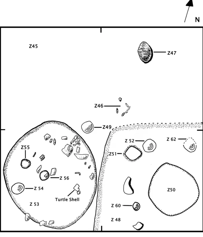
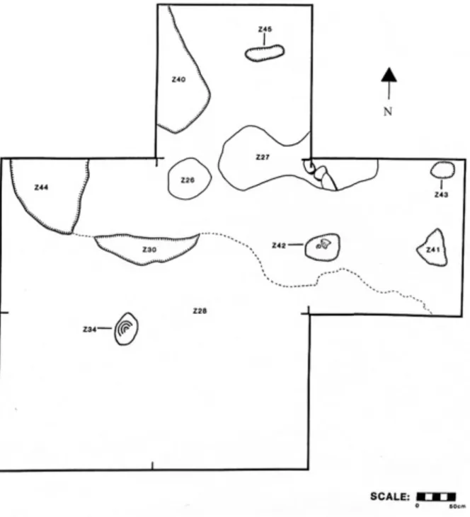
Operation 14 began as a 4x4 meter unit, but was expanded an additional two meters to the south to accommodate complete burial excavation. The earliest construction phases (Phases I and II), date to the Late Formative and Protoclassic periods, or around 200 BCE to 100 CE (associated with the K’atabche’k’ax ceramic complex, Late Facet). During Phase I, K’axob residents removed the original soil and dug pits into bedrock. Afterwards, they filled the pits and built a platform made up of midden deposits transported to the area as a single event or added to incrementally through time (Zone 44). Excavators found a fragment of plaster floor on the surface of the platform, along with a rock-lined posthole dug into the surface. Construction Phase II (Figure 4) included two well-preserved plaster (or packed marl) floors, hearths, pits, several postholes, and three child burials (Zones 47, 51, and 57). One small, 20x23 cm hearth (Zone 46) contained burnt limestone rocks.
hearth. Phase V was the first construction phase in which a single plaster floor covered the entire unit, and it was the best-preserved floor encountered in Operation 14. The phase included an adult burial placed in an intrusive pit with vessels (Zone 35c), and two large limestone rocks suggesting a wall alignment along the southern edge of the unit.
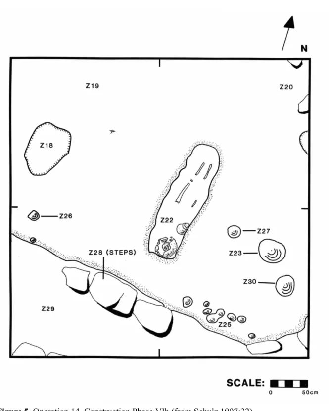
Construction Phases VI through VIII at Operation 14 date to the Late to Terminal Classic, or about 550 to 850 CE (Witsk’ax complex). In Phase VIa another plaster floor was discovered with a pit dug into it that could have been used for cooking (Zone 32). The pit measured 40x42 cm and contained animal bones and sherds (burned and unburned). Above these contexts, in Phase VIb (Figure 5), were two burials (one of which was Zone 22), a midden, another plaster floor, a variety of postholes, and a pit (Zone 18). Zone 18 measured 62x70x30 cm and contained just a few pieces of shell and a couple of sherds. Phase VII (Figure 6) included plaster floors, a small midden, several postholes, two walls, a cache, and a burial (Zone 14) containing a middle-aged adult (Rebecca Storey, personal communication 2013). Excavators encountered two additional burials but they were not excavated. The final construction phase, Phase VIII, included a plaster floor, three adult burials, and a large hearth (Zone 3) with charcoal and a few ceramic sherds. The hearth intruded into one of the burials (Zone 5).
Operation 15
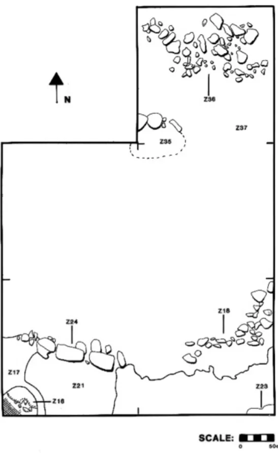
Kimberly Berry directed excavations at Operation 15. The unit consisted of an initial 4x4 m unit, eventually expanded to include three additional 2x2 m units that allowed for further exposure of unusual bedrock features (Berry 1997:44). Construction Phase I of Operation 15 (Figure 7) dates to the Late Classic period (550-750 CE; early Witsk’ax complex). It included a series of pits intruded into a bedrock ridge that may have been used as a downdraft kiln (López Varela et al. 2001). Within the pits, excavators discovered
amorphous lumps of fired clay, a diverse assemblage of sherds including shaped-sherd tools, figurine fragments, and powdery blocks that may have served as raw material for tempering pottery clay (Berry 1997:45; López Varela et al. 2001:185). A bedrock pit (Zone 44) could have functioned as a storage feature. Excavators also found the only posthole within
Operation 15 (Zone 34). In the fill of another pit, excavators encountered two disarticulated burials (Zone 26). Most recently, Rebecca Storey (personal communication 2013) reports that one burial (15-1) was a young to middle-aged adult and the other (15-2) was a child.
Construction Phase II (Figure 8) also dates to the Late Classic period (early Witsk’ax complex). K’axob residents filled in the kiln features and constructed walls along the
floor) and constructed a new wall. They placed a marl cap over the Zone 16 hearth at this time. Outside of the rock boundary, excavators found two cooking surfaces (Zones 8 and 9), on top of which sat dense scatters of apple snails (Pomacea flagellata; Zones 3 and 4). Immediately below the topsoil, excavators detected a final resurfacing event.
The entire sequence of construction found within Operation 15 occurred during the Late Classic period. Based on the walls and hearths, Berry (1997:63) concluded that through time K’axob residents transformed the area from a production space into a residential and domestic site. She argued, however, that the later residential function did not preclude the continuity of pottery production in the area. Excavators encountered fewer (two) burials within the unit when compared to Operation 14 (which contained eleven). The burials at Operation 15 were disarticulated and found within a bedrock pit, while burials from Operation 14 were interred as articulated primary burials within constructed cists and accompanied by burial goods during the Late Classic. Operation 15 contained earthen floors rather than the packed-marl floors seen in Operation 14. All in all, the features apparent in Operation 15 did not require the same amount of labor to construct as features from the larger structure viewed through the lens of Operation 14.
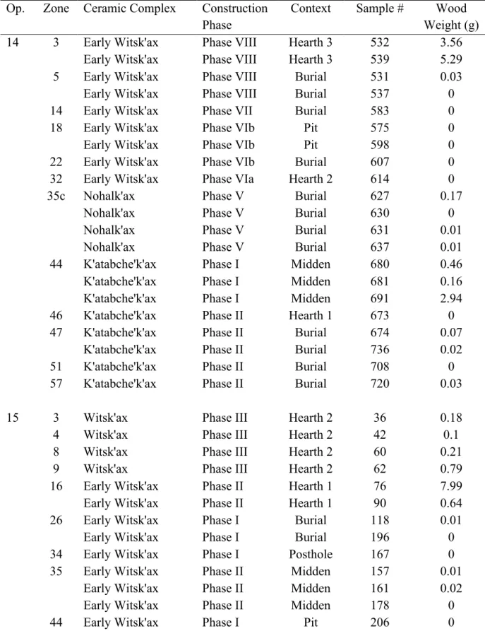
Botanical Samples
Table 2. Flotation samples from Operations 14 and 15 by zone, indicating phase, context, unique sample number, and wood weight.
Op. Zone Ceramic Complex Construction Phase
Context Sample # Wood Weight (g)
14 3 Early Witsk'ax Phase VIII Hearth 3 532 3.56
Early Witsk'ax Phase VIII Hearth 3 539 5.29
5 Early Witsk'ax Phase VIII Burial 531 0.03
Early Witsk'ax Phase VIII Burial 537 0
14 Early Witsk'ax Phase VII Burial 583 0
18 Early Witsk'ax Phase VIb Pit 575 0
Early Witsk'ax Phase VIb Pit 598 0
22 Early Witsk'ax Phase VIb Burial 607 0
32 Early Witsk'ax Phase VIa Hearth 2 614 0
35c Nohalk'ax Phase V Burial 627 0.17
Nohalk'ax Phase V Burial 630 0
Nohalk'ax Phase V Burial 631 0.01
Nohalk'ax Phase V Burial 637 0.01
44 K'atabche'k'ax Phase I Midden 680 0.46
K'atabche'k'ax Phase I Midden 681 0.16
K'atabche'k'ax Phase I Midden 691 2.94
46 K'atabche'k'ax Phase II Hearth 1 673 0
47 K'atabche'k'ax Phase II Burial 674 0.07
K'atabche'k'ax Phase II Burial 736 0.02
51 K'atabche'k'ax Phase II Burial 708 0
57 K'atabche'k'ax Phase II Burial 720 0.03
15 3 Witsk'ax Phase III Hearth 2 36 0.18
4 Witsk'ax Phase III Hearth 2 42 0.1
8 Witsk'ax Phase III Hearth 2 60 0.21
9 Witsk'ax Phase III Hearth 2 62 0.79
16 Early Witsk'ax Phase II Hearth 1 76 7.99
Early Witsk'ax Phase II Hearth 1 90 0.64
26 Early Witsk'ax Phase I Burial 118 0.01
Early Witsk'ax Phase I Burial 196 0
34 Early Witsk'ax Phase I Posthole 167 0
35 Early Witsk'ax Phase II Midden 157 0.01
Early Witsk'ax Phase II Midden 161 0.02
Early Witsk'ax Phase II Midden 178 0
drum with water sent from the bottom towards an opening at the top. A 1/16-inch screen was suspended within the tank, allowing soil to fall through the mesh to the bottom, while
botanicals floated to the top and were caught in net bags as light fractions. Heavy fractions included artifacts and rocks remaining on the screen after the sample had been floated. For this study, I only examined light fractions. Heavy fractions were sorted in the field
CHAPTER 4:
PLANT AND ANIMAL USE IN ANCIENT NORTHERN BELIZE
This section introduces previous research on faunal and botanical data from sites in northern Belize, including K’axob. After a wider overview of faunal studies in northern Belize, I present previous studies of apple snails (Pomacea flagellata) from earlier excavation seasons at the site, which I will supplement with additional data in the next chapter. Because this study introduces new plant remains from K’axob, I explore botanical studies from other sites in northern and central Belize in order to tease out the significance of various plants in the environmental and cultural history of the area. Based on this review of the literature, it becomes clear that more work to interpret botanical remains according to their specific contexts rather than their general presence or absence at sites will assist in answering the research questions pursued in this thesis. Through plant remains, scholars can access not only broad environmental changes but also information relevant to social topics such as ritual, work, and identities in the past (see also Morehart and Morell-Hart 2013). Faunal Remains
terrestrial habitats, but varied in the freshwater features locally available (Carr and Fradkin 2008:150). Colha and K’axob sat next to large low-lying freshwater wetlands. As a result, residents of Colha and K’axob utilized fish and other freshwater resources to a greater extent. Cuello, on the other hand, had better access to well-drained uplands for rainy season
cultivation. Consequently, residents of the site coordinated hunting, fishing, and collecting with wet season swidden farming in the uplands and dry season farming on wetland edges (Carr and Fradkin 2008:151). Colha would have used resources similarly, but with year-round fishing and an emphasis on white-tailed deer among hunted mammals. At K’axob, residents may have used more intensive farming methods (wetland edge and maybe riverine bank farming) early on, while conducting year-round fishing and catching small to medium mammals. There were fewer white-tailed deer found at K’axob, however. This might be explained by year-round wetland field farming, which would have altered the mosaic of habitats available locally.
Masson’s (2004b:396) findings from Formative period K’axob showed that residents depended on fish, turtles, and mammals “that easily adjust to agrarian conditions, including deer, peccary, armadillo, agouti, small rodents, and canids.” Catfish was the most common fish, while marine fish were not identified at the site (Masson 2004b:388). It seems that K’axob residents exploited small mammals regularly, but rarely utilized large-game
did for marine fishes, which researchers found at the larger sites of Cuello and Colha (Carr and Fradkin 2008:151).
Despite limited recovery of particular animal resources, Masson (2004b:396) detected variations in the proportions of diverse species through time. For example, exploitation of turtle increased tremendously from the Late Formative through the Protoclassic periods. She argues that residents thoroughly understood local environments and engaged in flexible procurement strategies based on fluctuating availability (Masson 2004b:396). Due to sustainable management practices, small sites around Pulltrouser Swamp maintained access to aquatic and terrestrial game through time (Masson 2004a:98).
Additionally, Masson (2004b) identified fauna found in ritual contexts at K’axob, including frog and fish bones as well as fetal deer teeth found in a cache from the Late Formative. These finds, deposited in a quadripartite arrangement of ceramic vessels, may have related to Cha-Chac rain rituals, as practiced in the region today, or other animistic practices (Masson 2004a:106). Samuel Sheehan (2002) wrote his honors thesis on an analysis of fauna unearthed during the 1995 field season at K’axob, including Operations 14 and 15. Excavators had found the greatest amount of faunal material in Zone 44 of Operation 14, a Late Formative (K’atabche’k’ax complex) midden rich also in botanical remains. Included in the diverse assemblage were the only crocodile bones found at the site. Crocodiles were not consumed in significant quantities until the Postclassic period (Masson 2004a). Before this time, they were most likely reserved for ritual activities.
(Masson 2004a:107). Residents consumed fish at a higher level in Formative period contexts. Throughout the Classic period, the use of mammals, including previously absent tapir,
increased. This may signify a return to a high forest environment during the Late Classic period (Sheehan 2002:13). This would be the first example of reforestation at this time. Masson concluded that K’axob residents’ diets were diverse and people exploited Pulltrouser Swamp sustainably (Masson 2004b).
Apple snails (Pomaceaflagellata) are amphibious gastropods that reside near the shore and can survive in warm shallow water or bury themselves in mud during dry spells (Covich 1983:124). Apple snails do not move much in a lifetime, which for them lasts only a year (Harrigan 2004:400). Initially, Nations (1979) cast doubt on the use of apple snails as a food source based on present-day avoidance of the species among the Lacandon Maya. Since that time, however, scholars have argued for the exploitation and even cultivation of this commonly encountered resource (Cook 1997; Cuddy 2000:196; Miksicek 1991; Pyburn 1989). Apart from use of the snails as food, the shells may also have been used to make lime for processing maize (Nations 1979). Apple snails also played an important role in ritual, for excavators encountered at least 46 apple snail shells within a single human burial at K’axob. In ritual activities, shells symbolized fertility and regeneration (Harrigan 2004:404; Aizpurúa and McAnany 1999). In general, apple snail shells are likely to be preserved, and thus their significance for diet and other uses could be exaggerated in comparison to other faunal remains (Hammond and Miksicek 1981).
intruded into prepared surfaces or yard areas. The pits were likely used to cook these mollusks in the Formative period.
There were other possible uses for sherd-lined pits as well, including lime soaking maize, maintaining a fire, and depositing trash (Bobo 2004). A bimodal size distribution characterized sherd-lined pits, indicating two size classes possibly for different purposes. Bobo (2004:104) suggests changing functions through time, perhaps related to maize
processing. She notes, “Just as large striated jars suitable for maize soaking become common at K’axob, sherd-lined pits disappear as a domestic facility” (Bobo 2004:104). The
construction and use of sherd-lined pits declined and finally disappeared in the Classic period, indicating widespread changes in food preparation.
Botanical Remains Formative Period
moschata), allspice (Pimenta dioica), and hackberry (Celtis sp.). Slightly after that, chile peppers (Capsicum annuum) were grown.
A variety of species were found from rich Late Formative period contexts at the sites of Cuello and Cerros (Crane 1996; Cliff and Crane 1989; Miksicek 1991). Based on
macrobotanical evidence, utilized crops included maize, chile peppers, tubers, squash, and cotton (Gossypium hirsutum). Small, wild legumes were found from these contexts, but not the cultivated common bean (Phaseolus vulgaris). In addition, tree species present included nance, avocado, coyol palm (Acrocomia aculeata), mamey (Pouteria sapota), guava
(Psidium sp.), ziricote (Cordia dodecandra), and persimmon (Diospyros sp.). Pollen was found from copal (Protium copal), papaya (Carica papaya), bottle gourd (Lagenaria sp.), and cattail (Crane 1996). Tree pollen included avocado, mamey, and caimito (Chrysophyllum sp.).
Crane (1996) argued that the consumption of tree fruits increased dramatically through time, from 275 BCE to 50 BCE. It is intriguing to consider the idea that people began cultivating fruit trees when an elite class emerged at Cerros. Orchards are symbols of wealth related to heritable land ownership (McAnany and Murata 2006). Crane’s argument is supported by a simultaneous increase in the consumption of turtle, dog, deer, and peccary, also associated with high status. Unfortunately, it is unclear from her publications whether orchard species were found particularly within certain types of contexts, such as high status residences. An analysis of the differential use of plants within varying spaces at the site could strengthen her correlation between fruit tree cultivation and the emergence of wealth
Classic Period
Paleoethnobotanical studies have been conducted at the Classic period sites of Chau Hiix, Guijarral, and Blue Creek in northern and northwestern Belize (Bozarth and Guderjan 2004; Cuddy 2000; Goldstein and Hageman 2010). At Chau Hiix, Cuddy (2000) found a variety of seeds including geranium (Geranium sp.) and wild grape (Vitis sp.) in raised fields. He also found calabash rind, gourd rind (Cucurbita sp.), and palm fruits. In terms of wood, Cuddy found that early on residents of Chau Hiix used mostly pine for fuel. Through time, however, the primary fuel they used changed. After pine, they depended primarily on
hardwood, and finally palm. However, pollen evidence showed increased availability of pine through time, so Cuddy argued that these shifts represented social and economic changes rather than overuse of the resource. Pine may have been bought and sold as a commodity. Nonetheless, “pine charcoal was recovered from nearly 90% of all contexts excavated,” so it was never completely absent from the site (Cuddy 2000:179). This could be partially
explained by the proximity of pine savanna to the site of Chau Hiix (Cuddy 2000:183). This study presents another example of a paleoethnobotanical investigation that focuses primarily on large-scale changes through time. In many cases, and in this study in particular, botanical sample sizes from Maya sites are quite small as a result of poor preservation. This challenge makes finer-grade analyses more difficult. However, Cuddy still manages to make
suggestions about the values of different wood types and their possible roles in larger economic systems.
contexts, one associated with an ancestor shrine, and the other with a residential structure. They found remains from plants that grow in successional forest stands, such as guava (Psidium sp.) and cohune palm (Attalea cohune), associated with terraces and check dams (Goldstein and Hageman 2010:434). The authors argue that the triumvirate of maize, beans, and squash has been overemphasized among scholars, and that other foodstuffs will better enable the study of intrasite social inequality (Goldstein and Hageman 2010:422).
Caves, Ritual, and Status in the Classic Period
To expand our understanding of Maya ritual practice during the Classic period, Christopher Morehart studied plants from the caves of central Belize (Morehart and Butler 2010; Morehart 2005, 2011). Caves were liminal spaces for ritual events throughout Maya history. They were seen as transitional spaces between the earth and the underworld, night and day, and life and death (Morehart 2011:16). They were also thought to be places of fecundity where the rain deity dwelled (Thompson 1970:251). According to Classic Maya iconography and archaeological remains, cave rituals almost always included the burning of food and substances such as wood, pine resin, and copal incense, which allowed ritual practitioners to feed and communicate with ancestors and deities (Houston and Taube 2000:267; Morehart 2011:14). Other non-edible plants used in cave ceremonies included flowers, found in pollen samples from Gordon’s Cave III (Rue et al. 1989:399) and tobacco (Nicotiana sp.; Robicsek 1978).
Tobacco was used in rituals, and appears in sculptures and vase paintings as cigars smoked by elite lords (Robicsek 1978). The smoke of the cigars was represented in a fashion similar to breath, aroma, and wind (Houston et al. 2006:114; Morehart 2011:14). In the Late Classic period, miniature ceramic bottles generally about 5 cm tall were used as tobacco snuff flasks. Hieroglyphs painted or incised on these vessels indicate their use as tobacco powder containers. Recently, one such vessel was tested using gas and liquid
chromatography mass spectrometry; nicotine alkaloids were detected, demonstrating that the flask did indeed hold a tobacco compound (Zagorevski and Loughmiller-Newman
There was a miniature flask found at K’axob, in Operation 16, within construction fill on a packed-marl surface dating to the Late Classic period (Figure 9). It is a jar with a
vertical neck, 4.7 cm tall and 3 cm in rim diameter (López Varela 1997:224). The vessel had two handles, although one is missing. This vessel probably held tobacco, because, though lacking hieroglyphs, its shape closely resembles those of vessels designated for tobacco use, including the one found to have a tobacco compound (Zagorevski and Loughmiller-Newman 2012:Figure 1).
Figure 9. Miniature flask from Operation 16, Zone 8, found during the 1995 K’axob field season (from Terranova et al. 1996).
likely reflects tobacco’s increasing importance as a status plant and the formalization of its use.
Christopher Morehart (2005, 2011) found a variety of cultigens in Classic period cave contexts from the Belize River Valley, including maize, squash, beans, and chile peppers, some of which were wrapped in cotton textiles. The offerings were unprocessed
domesticated crops. Crops were characteristically found in rural cave sites that were likely used for rituals dedicated to earth deities (Morehart 2011:123). These cultigens would have been offered as symbolic payments to the deities in exchange for agricultural productivity. All people, including lower status groups and farmers, could have participated in such practices to offer ritual payment to the earth deities. Still today, Tzotzil Maya peoples visit caves to communicate with and remunerate the Earth Lord for rain and fertility (Morehart 2005:174; Vogt 1969:457).
Palenque, showed his ancestors associated with fruit trees, including cacao, nance, and avocado (Robertson 1983:Figures 181-186).
Morehart (2011) found pine charcoal at all of the cave sites he examined. According to Morehart and colleagues (2005), burning of pine may have been an essential component of any valid ritual practice. Pine continues to be used in ceremonies today (Morehart 2011:107; Vogt 1976:6). Based on linguistic evidence, pine torches may have been the precursor to the currently prevalent use of candles in Maya rituals. On the other hand, pine torches would have provided light for people to see within caves, and thus pine served a practical purpose in these contexts.
David Lentz and colleagues (2005) have written about trade in pine, noting that pine charcoal was more abundant in contexts associated with higher status residences,
independent of the locations of modern pine sources (see also Morehart and Helmke 2008). They argued that pine was not freely available in the marketplace but circulated through political alliances (Lentz et al. 2005). Within the sites of Xunantunich and San Lorenzo, pine use was relatively common in all households, without differentiation by status. However, when non-elite residences at Xunantunich were compared with those of a smaller site, Chan Nòohol, the farmers living at the rural site had much reduced access to pine, despite their similar status (Lentz et al. 2005:581). Thus, it is possible that the rulers of each polity
The studies described above, which surveyed plant remains in caves and residential contexts, illustrate the value in examining species present by context. By disaggregating site data, information becomes available about differential access to resources as well as more specific uses of particular plants. Morehart compared plant remains from different caves in the Belize River valley, and as a result he could discern the distinct roles caves could play for different segments of the ancient Maya population. Lentz and colleagues compared pine abundance within residences of diverse statuses at different sites. Consequently, they detected differences between structures of similar sizes that otherwise would have looked remarkably alike.