Marc Jeuland
A dissertation submitted to the faculty of the University of North Carolina at Chapel Hill in
partial fulfillment of the requirements for the degree of Doctor of Philosophy in the
Department of Environmental Sciences and Engineering
Chapel Hill
2009
Approved by:
Professor Dale Whittington
Professor Donald Lauria
Professor Harvey Jeffries
Associate Professor Gregory Characklis
Assistant Professor Jason West
A
BSTRACTThis research developed an integrated framework for conducting economic assessment of water resources infrastructures in the context of climatic and development uncertainty. Two levels of simulation make up the framework: the hydrological, based around the river basin routing model; and the economic, which utilizes Monte Carlo simulation methods to simulate the net present value of projects given variation in economic model parameters. A number of linkages between climate and the performance of the system were included: changes in runoff, reservoir evaporation rates and crop water requirements, as well as economic changes in the value of water, energy and carbon offsets.
The framework was made operational for a real-world planning application in the Nile Basin. It was first used to study in detail the effect of the climate linkages on the economics of a single proposed hydropower dam on the Blue Nile in Ethiopia. An illustrative climate scenario, drawn from the set of emissions futures considered by the Intergovernmental Panel on Climate Change (IPCC), was used for this evaluation. Several climate change linkages were found to have important effects on the system and the economics of the project: climate-perturbed runoff, increases in crop water requirements due to higher temperatures, and changes in the value of energy and carbon offsets.
The research was then extended to evaluate the costs and benefits of constructing
alternative configurations of Blue Nile hydropower dams, for four possible water withdrawal conditions and a range of climate scenarios. The effects of project design and operational features were also evaluated. The analysis showed that: 1) many projects provide positive net benefits across a range of conditions; 2) increased system water withdrawals have a significant negative impact on the
iv
A
CKNOWLEDGEMENTSI wish to express my sincere thanks to each of my dissertation committee members. This work would never have been possible without their patient guidance. I especially thank my advisor and committee chair, Dale Whittington, who first offered me the opportunity to work on Nile Basin planning during the fall of 2005. Donald Lauria and Gregory Characklis also offered invaluable advice throughout my graduate studies and proved to be tireless advocates on my behalf.
Special thanks are also due to N. Harshadeep at the World Bank, who inspired me by his keen awareness of the political and technical realities of international river basins. Many others worked alongside him and helped advance my thinking on the policy implications of this research: Barbara Miller, Claudia Sadoff, Winston Yu, Benoit Laplante among others.
While traveling in the Nile Basin, transcribing and organizing data and reading planning documents, I had the honor of working with many helpful people at the Eastern Nile Technical Regional Office (ENTRO) and in the Nile Basin Initiative (NBI) Water Resources Planning Model Group, including Mohamed Abdel Aty Sayed, Yohannes Daniel, Ahmed Khalid, Mekuria Tafesse, Abdulkarim Seid. Not only did these people help facilitate my work, they always made me feel welcome in Addis and at regional meetings in Cairo. There too, I met and benefited from the
collaboration of people associated with the NBI and the Ministry of Water Resources: Wahil el-Khairy, Eman Soliman, Mohamed Elshamy, and many others.
T
ABLE OFC
ONTENTSAbstract ... iii
Acknowledgements ... iv
Table of Contents ... v
List of Tables ... ix
List of Figures ... xi
List of Figures ... xi
Abbreviations and Acronyms ... xv
Units of Measurement ... xvii
CHAPTERS 1 Introduction ... 1
1.1 Climate change and the planning of water resources investments ... 3
1.2 The need for a modified approach ... 6
1.3 Policy questions ... 11
1.4 Research goal and objectives ... 12
1.5 Contribution ... 17
1.6 Limitations ... 17
PART A: LITERATURE AND METHODOLOGY ... 20
2 Literature Review ... 21
2.1 General climate change impacts on water resources ... 21
2.2 Climate change and the water resources investment planning literature ... 26
2.3 Nile Basin climate projections ... 29
2.4 Summary ... 31
3 Adapting the water resources planning framework ... 33
vi
3.2 Challenges to using the basic planning framework ... 38
3.3 The integrated hydro-economic simulation framework ... 43
3.4 Summary ... 45
4 Operationalizing the framework for the Blue Nile planning problem ... 46
4.1 a) Definition of climate scenarios and project alternatives; b) selection of a scenario and project alternative for analysis ... 48
4.2 Specification of linkages between climate and the water resources system... 49
4.3 Generation or choice of inflows corresponding to climate scenario runoff ... 53
4.4 Simulation of physical incremental changes due to the project alternative being analyzed ... 59
4.5 Cataloguing the physical measures of the project’s incremental effect on the system ... 59
4.6 Simulation and storage of economic outcomes for the climate scenario and project ... 60
4.7 Selection of the next climate scenario, and/or project alternative; repetition of steps 1-6 ... 61
4.8 Analysis of results and evaluation of the project alternatives ... 61
4.9 Summary ... 62
PART B: EXISTING AND REVISED ANALYSES OF THE BLUE NILE PROJECTS WITHOUT CLIMATE CHANGE ... 63
5 Background on the Blue Nile infrastructure planning problem... 64
5.1 Pre-feasibility study designs for Blue Nile infrastructures ... 64
5.2 Economic costs and benefits of the Blue Nile projects ... 69
5.3 The social rate of discount under climate change ... 78
5.4 Comparing economic costs and benefits of the JMP projects obtained using the hydro-economic framework with those found in the pre-feasibility studies ... 86
5.5 Economic analysis of the three infrastructure projects ... 91
5.6 Summary ... 97
PART C: INTEGRATING PLANNING UNCERTAINTY INTO THE ANALYSIS ... 99
6 The physical aspects of dynamic development in the Nile Basin, and its potential interaction with climate change ... 100
6.2 Current development and historical climate ... 111
6.3 The effect of increased development with historical climate ... 112
6.4 The effect of climate change in the baseline withdrawal condition ... 115
6.5 The two dimensions of the dynamic baseline: climate change and evolving water withdrawals 122 6.6 Summary of system outputs under differing climate change and development futures ... 125
6.7 Discussion ... 128
7 Using the integrated framework: Climate change and the economics of Mendaya ... 132
7.1 Analytical approach ... 132
7.2 Results ... 136
7.3 Summary ... 152
8 Extending the analysis: Comparison of the infrastructures... 156
8.1 Analytical approach ... 156
8.2 The simulation experiments ... 158
8.3 Results ... 163
8.4 Investments favored under different decision criteria ... 184
8.5 Discussion ... 186
9 The strengths and weaknesses of the alternatives: An analysis of options ... 191
9.1 Conceptual model ... 191
9.2 Definition and evaluation of comparative metrics ... 193
9.3 Results ... 197
9.4 Discussion ... 212
10 Additional thoughts on discounting: States of the world ... 215
10.1 The long run growth rate in the modern world economy... 216
10.2 Approach: specifying three plausible future states of the world ... 218
10.3 Parameterization of the social consumption discount rate ... 220
10.4 Results ... 221
viii
11 Conclusions ... 231
11.1 Summary of research methodology and the value of an integrated model ... 231
11.2 Review of policy questions and main findings ... 235
11.3 Specific and general limitations of the analysis ... 237
11.4 Concluding thoughts on the imperative for cooperation in the Blue Nile ... 247
12 References ... 251
Appendices ... 264
Appendix A: Additional tables and figures ... 265
Appendix B: Nile Stochastic Streamflow Generator ... 276
Appendix C: Nile Simulation Model ... 291
Appendix D: Economic Analysis of Reservoirs Model... 309
L
IST OFT
ABLESTable 1. Summary of climate futures in the Special Report on Emissions Scenarios ... 22
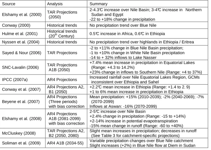
Table 2. Summary of Nile studies of historical climate trends and future projections ... 30
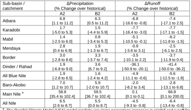
Table 3. Summary of three-model mean projections for the Nile Basin for 2050 ... 31
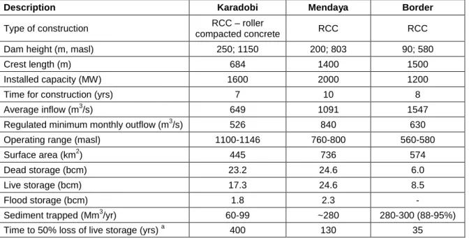
Table 4. Design attributes for proposed dams, from pre-feasibility studies ... 66
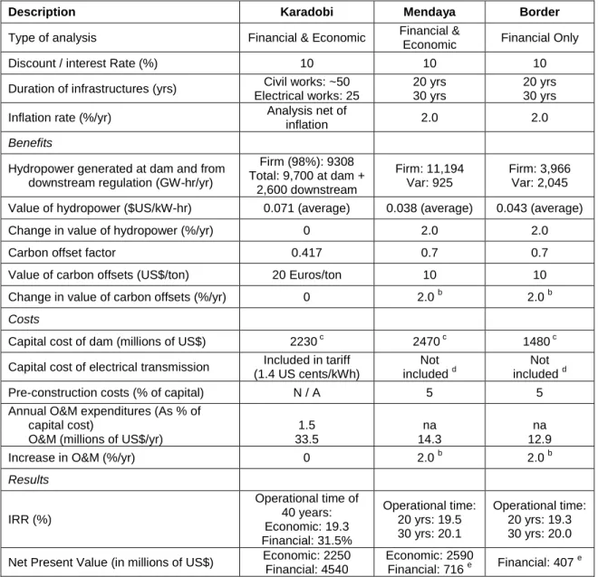
Table 5. Key economic/financial parameters and findings from the pre-feasibility studies ... 67
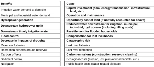
Table 6. Benefits and costs of large water projects ... 70
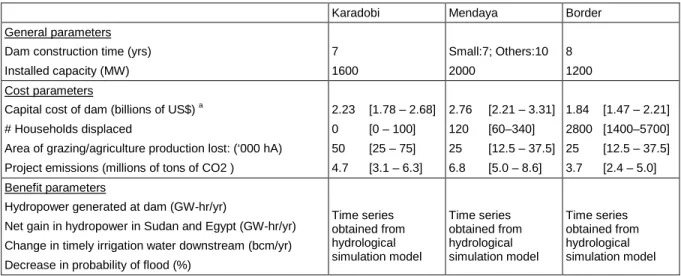
Table 7. Parameter assumptions for costs and benefits that vary across infrastructure alternatives .. 71
Table 8. Parameter assumptions that are the same across alternatives ... 72
Table 9. Discounting assumptions of different authors in their assessments of climate change ... 84
Table 10. Comparison of analyses in the pre-feasibility studies and this research ... 87
Table 11. Summary of parameter distributions for economic simulations... 89
Table 12. Base case economic results for the Karadobi, Mendaya and Border dams ... 92
Table 13. Summary of water withdrawal conditions ... 103
Table 14. Summary of climate scenarios ... 106
Table 15: Nile water balance for the three water withdrawal conditions, with historical climate ... 114
Table 16: Nile water balance for A2_D0: A2 climate change projections and status quo withdrawals ... 119
Table 17: Sensitivity analysis of the effect of climate change on the Nile water balance with status quo irrigation.D0 ... 120
Table 18: Nile water balance with moderate and high upstream irrigation, and climate change ... 124
Table 19. The effect of the climate change linkages on the water balance of the Nile system, with and without Mendaya ... 138
Table 20. Results of individual linkage experiments ... 142
Table 21. The effect of the climate change linkages on the economics of the Mendaya project ... 147
Table 22. Summary of project alternatives and nomenclature system ... 159
Table 23: Summary of decision rules applied to the Blue Nile development problem ... 162
x
Table 25: Nile water balance across climate scenarios, with and without Blue Nile Dams
(Pre-feasibility project designs: Infm_T1_Sp_O1) ... 166
Table 26: Investments favored by the different decision criteria ... 185
Table 27. Summary of infrastructure bundles ... 197
Table 28. Stability of “best” infrastructure choices given changing inflow scenario probabilities ... 203
Table 29. Summary of operating rules chosen for the “best” infrastructure, chosen on the basis of highest expected NPV ... 214
Table 30. Summary of proposed discount rate parameters. ... 219
Table 31. Economic model parameters contributing most to uncertain outcomes in different economic “states of the world” ... 227
L
IST OFF
IGURESFigure 1. The Nile watershed. ... 2
Figure 2. The three dimensions of unmeasurable uncertainty in the policy problem as conceptualized in this research. ... 8
Figure 3. (A) The traditional framework for economic appraisal of water resources investments and (B) the proposed simulation approach developed in this research. ... 14
Figure 4. The traditional framework for economic appraisal of water resources investments ... 34
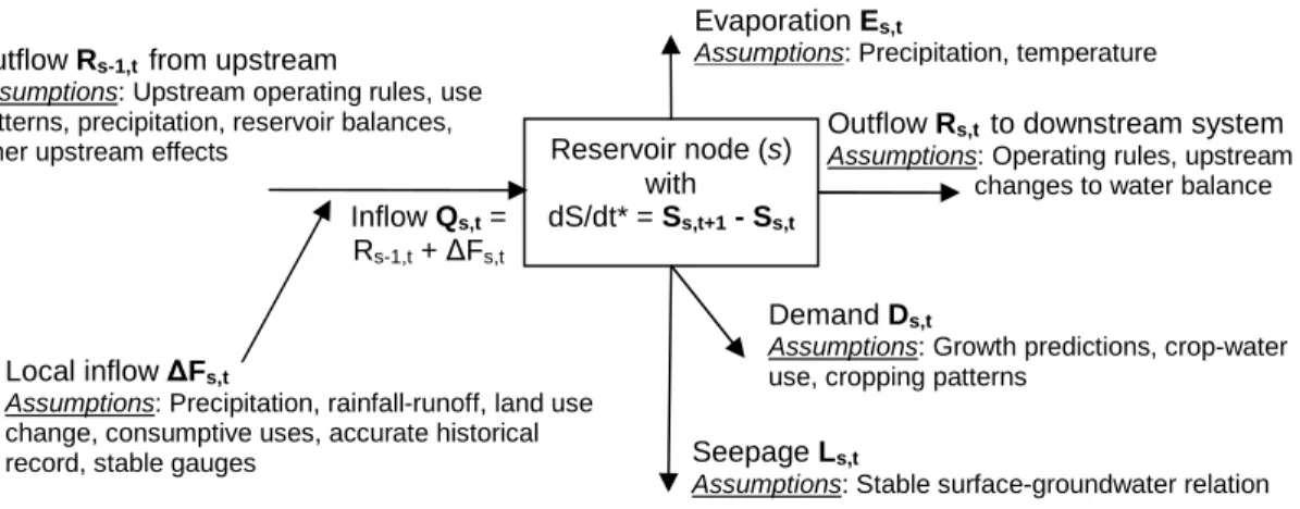
Figure 5. Illustrative representation of a reservoir node connected to ordinary flow nodes. ... 36
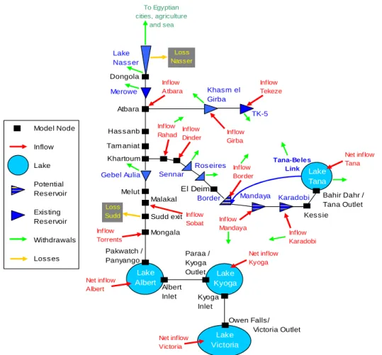
Figure 6. Illustrative representation of nodes modeled in a water resources system ... 41
Figure 7. A modified simulation framework for economic appraisal of water resources investments. . 44
Figure 8. Flow chart showing the operational framework. ... 47
Figure 9. Simmodel.xls schematic, showing inflow, routing and reservoir nodes ... 48
Figure 10. Climate linkages within the modified simulation framework ... 49
Figure 11. Procedure for generation of synthetic inflow series’ with a monthly time step ... 53
Figure 12. Observed and simulated net inflows for three example nodes in the Nile Basin model. .... 57
Figure 13. Observed net inflows and a random sequence of net inflows decreased by 10% for three example nodes in the Nile Basin model ... 58
Figure 14. Abbay River basin in Ethiopia ... 65
Figure 15. Time series of undiscounted net benefits from Karadobi in the base case analysis ... 93
Figure 16. Categories of costs and benefits for the Mendaya Dam in the base case analysis ... 94
Figure 17. A) Cumulative distributions of NPV outcomes for the three infrastructures in the “historical” condition, and B) balance of cost and benefit components for the high and low outcomes ... 95
Figure 18. The sensitivity of Karadobi NPV outcomes to model parameters ... 96
Figure 19. The effect of natural variability in hydrology on economic outcomes ... 98
Figure 20. Modeling two dimensions – climate change and the evolving regime of water withdrawals – of unmeasurable uncertainty in the “dynamic baseline” of the policy problem. ... 101
Figure 21. Changes in precipitation and runoff projected for 2050 using the TAR Models ... 107
xii
Figure 23. Nile water balance for H_D0 condition. ... 113
Figure 24. Summary of key indicators related to climate scenario linkages for A2_D0 experiment ... 116
Figure 25. Nile water balance for A2_D0 condition including existing infrastructures. ... 118
Figure 26. Average hydropower production from existing dams in Sudan and the High Aswan Dam, across climate scenarios ... 126
Figure 27. Deficits in Sudan and Egypt, across climate scenarios ... 127
Figure 28. Hundred-year maximum flows along the Blue Nile in Sudan, across climate scenarios .. 128
Figure 29. Net inflows to Lake Nasser under different assumptions about climate change and development ... 130
Figure 30. Modeling the effect of A2_D1 conditions on the economics of the Mendaya project. ... 133
Figure 31. Nile water balance for the H_D1 condition. ... 136
Figure 32. Change in water balance at Lake Nasser across the D0-D3 water withdrawal conditions, under A2 climate conditions with Mendaya ... 140
Figure 33. The effect of the climate change linkages on system hydropower production ... 144
Figure 34. The effect of the physical linkages on Mendaya project NPV outcomes. ... 146
Figure 35. The cumulative effect of the climate change linkages on the Mendaya NPV. ... 147
Figure 36. The effect of inflow variation on Mendaya NPV outcomes, with D1 withdrawals ... 148
Figure 37. Balance of cost and benefit components for the high and low NPV outcomes ... 149
Figure 38. The effect of changes in withdrawals on Mendaya NPV in the A2 climate scenario. ... 150
Figure 39. The cumulative effect of the climate change linkages on Mendaya NPV. ... 151
Figure 40. The effect of individual parameters on Mendaya NPV in the A2_D1 situation. ... 152
Figure 41. Modeling for the various JMP ‘anchor’ project alternatives in the context of climate and development uncertainties. ... 157
Figure 42. The effect on the system water balance of adding A) Karadobi and B) a Blue Nile 3-dam cascade ... 168
Figure 43. Change in system irrigation deficits from Inf0 to Infm_T1_Sp_O1 experiments. ... 170
Figure 45. System hydropower added to the system across inflow scenarios with different
infrastructures operated using the hydropower-based rules. ... 173
Figure 46. Change in system hydropower added to the system across inflow scenarios with different infrastructures ... 175
Figure 47. Cumulative distributions of NPV for multi-dam combinations ... 175
Figure 48. Mendaya NPV across inflow scenarios. ... 178
Figure 49. Karadobi NPV as a function of inflow variability scenarios. ... 179
Figure 50. NPV distributions from simulations for different sizes of the Mendaya Dam. ... 180
Figure 51. NPV distributions from simulations of A) Mendaya + Border, and B) Mendaya + Karadobi ... 181
Figure 52. Mendaya NPV with A) variable filling rates, and B) coordination of releases with Lake Nasser. ... 183
Figure 53. Border NPV in the Inf3_T0_S0_O1,4,5;A2_D1 experiments ... 183
Figure 54. The effect of moving from D0 to D2 withdrawals on A) expected NPV of the infrastructure combinations with the highest expected NPV, and b) risk of negative net benefits for the infrastructure with the lowest risk of NPV<0, across the different climate scenarios. ... 186
Figure 55. The tradeoff between 90th percentile upside NPV in the +6_D0 situation, and the risk that project NPV will be negative in the -15_D0 situation. ... 189
Figure 56. Partial decision tree of Blue Nile planning process ... 193
Figure 57. The highest expected NPV for each configuration’s best performing bundle. ... 200
Figure 58. The risk-reward tradeoffs for the infrastructure bundles. ... 201
Figure 59. The relative performance of the single dams across inflow scenarios. ... 205
Figure 60. The relative performance of the two-dam configurations across inflow scenarios ... 207
Figure 61. The relative performance of the three-dam configurations across inflow scenarios ... 209
Figure 62. The cost of waiting relative to a) balanced, b) conservative, and c) risk-taking strategies ... 211
xiv
Figure 65. The marginal elasticity of utility obtained using different values of α and β ... 221 Figure 66. The discount rate for the three states of the world developed in Table 29 ... 222 Figure 67. Expected NPV for the medium Mendaya dam in the three discounting cases. ... 224 Figure 68. Percent of simulations with NPV<0 for the mid-sized Mendaya dam in the three
A
BBREVIATIONS ANDA
CRONYMSAEJ African Easterly Jet
AOGCM Atmosphere-Ocean General Circulation Model
AR4 Fourth Assessment Report of the Intergovernmental Panel on Climate Change CGE Computable General Equilibrium
EARM Economic Analysis of Reservoirs Model ENCOM Eastern Nile Council of Ministers ENPM Eastern Nile Planning Model
ENSAP Eastern Nile Subsidiary Action Program ENSO El-Niño Southern Oscillation
ENTRO Eastern Nile Technical Regional Office FAO Food and Agriculture Organization GAMS General Algebraic Modeling System GCM General Circulation Model
GPCC Global Precipitation Climatology Center
HAD High Aswan Dam
IMPEND Investment Model for Planning Ethiopian Nile Development
IOD Indian Ocean Dipole
IOZM Indian Ocean Zonal Mode
IPCC Intergovernmental Panel on Climate Change IRR Internal Rate of Return
xvi
MIWR Ministry of Irrigation and Water Resources, Sudan MoWR Ministry of Water Resources, Ethiopia
MWRI Ministry of Public Works and Water Resources, Egypt NBI Nile Basin Initiative
NCAR National Center for Atmospheric Research NELSAP Nile Equatorial Lakes Subsidiary Action Program NEOM Nile Economic Optimization Model
NFS Nile Forecast System
Nile-DST Nile Decision Support Tool
NPV Net Present Value
OSI One-System Inventory
PCMDI Program for Climate Model Diagnosis and Intercomparison PET Potential Evapotranspiration
RACMO Regional Atmospheric Climate Model RAPSO Reservoir and Power Station Operation
RCM Regional Climate Model
SOI Southern Oscillation Index
SRES Special Report on Emissions Scenarios
SST Sea-Surface Temperature
SVP Shared Vision Program
TAR Third Assessment Report of the Intergovernmental Panel on Climate Change USBR United States Bureau of Reclamation
VARG Value at Risk-Gain
WCD World Commission on Dams
U
NITS OFM
EASUREMENTbcm Billion cubic meters GW-hr/yr Gigawatt-hour per year
km2 Square kilometers
kW-hr Kilowatt-hour
m Meter
m3 Cubic meter
masl Meters above sea level Mm3/yr Million cubic meter per year
1
I
NTRODUCTIONAs the international debate over global climate change heats up, societies around the world are beginning to consider and respond to the specific effects it is having on them. The problem seems so vast, and its uncertainties so large, that it is difficult to imagine where societies and governments should devote their energies. To what extent should individuals and firms be expected to
autonomously adapt and innovate in the face of changing conditions? What role should governments play in aiding adaptation as well as entering into a global compact for reducing greenhouse gas emissions? What will be the distributional impacts of climate change, and how should these be addressed? How can established institutions and planning agencies account for the wide range of changes that scientists deem possible? Is humanity’s very existence at stake?
While these climate change issues are discussed, societies, institutions and nations continue to face the same basic question of development, that is, how best to advance the well-being of their people. In the Eastern Nile, a region covering the Nile River’s watershed in Ethiopia, much of Sudan and Egypt (Figure 1), this question increasingly revolves around concerns over the growing scarcity of water resources. Policy makers and specialists in the Nile Basin wonder how water resources can best advance greater societal development without harming and destabilizing existing users, and about the practical implications of climate change for basin planning. In addition, they are operating within an uncoordinated water development regime, characterized by unilateral projects: expansion of new irrigation projects and construction of large storage reservoirs in hot and arid regions, and significant irrigation and diversion projects in the upstream reaches of the Blue Nile. These
developments, as well as others being envisioned for the near future, raise important questions about where the current development regime will lead the three riparians.
seeks to establish a cooperative development strategy for increasing the collective benefits from use of the Nile waters. Much discussion has revolved around planning an anchor project for the JMP, which is to deliver important benefits and help to build trust among the three Eastern Nile riparians.
Figure 1. The Nile watershed. The Eastern Nile comprises the Baro-Akobo-Sobat, White Nile, Blue Nile, Tekeze-Atbara and Main Nile. Black lines show existing water control structures; red circles
show locations for proposed Joint Multipurpose Programme (JMP) projects in Ethiopia.
Previous work indicates that the Blue Nile canyon in Ethiopia could be a highly attractive location for such a cooperative project (Whittington et al., 2005; Wu and Whittington, 2006;
Blackmore and Whittington, 2009). Most of the Blue Nile basin upstream of Egypt and Sudan remains unregulated and undeveloped, and it appears to contain three or four attractive sites for large water resources infrastructures. These locations have significant hydropower potential, favorable surface-to-volume ratios for reservoirs, low potential for displacement of local households and disruption of livelihoods, and low risk of earthquakes (Whittington et al., 2008).
3
transparent and thorough. There are several notable challenges for the planning process to confront. First, it must take into account the potential for system-wide benefits and costs that would result from the upstream flow regulation induced by these storage projects. Second, the existing, mostly
unilateral development regime creates a situation where the baseline to which cooperative projects will be added is uncertain and in flux. Third, initial research suggests that arid and semi-arid
developing countries (such as the Nile riparians) are particularly vulnerable to the impacts of climate change (Gleick, 1991; Conway and Hulme, 1996; Conway et al., 1996; Abou-Hadid, 2006; Sayed and Nour, 2006; Deressa, 2007; IPCC, 2007a; Strzepek and McCluskey, 2007). New or existing
infrastructures, including dams, may play an important role in adaptation to climate change, depending on how they are sized and sequenced, as well as whether they are managed with other infrastructures in coordinated fashion. This, however, is complicated by the fact that there is substantial uncertainty concerning how climate change will impact the Nile. Finally, since the Nile Basin system already appears highly constrained in terms of water availability, the economic consequences of even small changes in the water balance can be substantial.
This dissertation is the culmination a four-year intellectual journey in the Nile Basin, and one which will continue beyond my graduate studies. At present, I have a strong feeling that the countries participating in the JMP face an exceptional opportunity. On the one hand, they could maintain the status quo development regime, one which yields piecemeal and targeted gains from isolated projects in specific areas but may have adverse consequences – both direct and indirect. On the other hand, they could subscribe to a more holistic approach that explicitly accounts for the basin-wide spillovers of large development projects, setting a new standard for international water resource management. This research aims to assist the evolution towards the latter approach, demonstrating new simulation tools for considering some of the important uncertainties in the appraisal of new projects, and proposing strategies for interpreting their results. Let us now consider in more detail some of the larger issues which motivate this work.
1.1 Climate change and the planning of water resources investments
attributable to rising atmospheric concentrations of greenhouse gases will affect ocean and land surface temperatures, precipitation patterns, evapotranspiration rates and the demand for water in agriculture, the frequency and intensity of storms, the timing and magnitude of runoff, and sea level in coastal communities, all of which will affect water resources systems (Frederick and Major, 1997; IPCC, 2007a). Though there has been fairly extensive research aimed at assessing the magnitude of such impacts under different emissions scenarios both globally and in specific regions (Leavesley, 1999; Arnell, 2004; Milly et al., 2005), limited guidance exists on how these effects of global warming should be integrated into planning for new capital-intensive investments in water resources, as well as rehabilitation of old infrastructure.
Conceptually, climate-related changes in water resource systems can be thought of as occurring at two levels: hydrological (or physical) and economic. At the physical level, there are clear linkages between climatic factors such as temperature and precipitation and the hydrology of surface water systems. These factors can be built into mathematical descriptions of those systems
(hydrological models), in order to study how they influence system behavior. For example,
temperature changes can be linked with net evaporation from storage structures and water demands in irrigated lands, and effects on stream flows can be predicted based on changes in future
precipitation and/or runoff. There has been substantial academic and practical progress
demonstrating how these types of changes can be incorporated into hydrology models (Conway and Hulme, 1996; Frederick and Major, 1997; van Dam, 1999; Arora and Boer, 2001; de Wit and
Stankiewicz, 2006). Typical applications usually consider a subset of changes and are conducted in the context of assessing vulnerability rather than planning new investments or adaptation strategies.
5
may favor hydroelectric power over use of conventional sources due to the increasing value of carbon offsets. Second, consumption patterns of resources such as water will change. For example, warmer temperatures may increase the demand for energy used for cooling while decreasing heating
requirements. Sea level rise may increase the demand for minimum flows in river basins threatened with salt water intrusion. These varied production and consumption effects could perturb the real value of water resources system outputs. In other work, Sterner and Persson (2008) have shown that relative price changes are important in thinking about the economic implications of climate change. Specifically, they show that relative price increases for natural goods can be sufficient to justify taking stronger action to avert climate change than ordinary economic analysis would recommend. Similar effects could alter the economics of investment in sectors relying heavily on natural resources.
Unfortunately for the water resources analyst, there is much uncertainty associated with these types of hydrological and economic changes. Plus, current tools do not readily allow determination of which types of climate-related processes and uncertainties are significant for planning. Nor is it known how these compare with uncertainties related to other features of the development and investment problem. The value of water and hydropower, and its evolution over time, depend on regional and global influences that encompass much more than just climate change. Because of the longevity of investments in the water resources sector, the issue of forecasting such changes has long troubled planners.
Also crucial to this evaluation problem is the fact that transboundary water systems usually include many possibilities for development that may not be included in existing or formal planning processes. In the Eastern Nile, for instance, we might observe that the JMP planners may not be able to fully control all aspects related to water resources development. For example, Egyptian planners may have limited influence on national or sub-national planning in Ethiopia, and vice versa.
Nonetheless, if they want to make well-informed investment decisions, these planners need to better understand and anticipate the consequences of and interactions among these possible
1.2 The need for a modified approach
In order to begin to address these limitations, this research develops and demonstrates a hydro-economic modeling framework for integrating climate change impacts into the traditional water resources planning problem. The two-level framework allows for simultaneous consideration of the types of physical and economic impacts described above. The first level relies on stochastic simulation of stream flows and incorporates physical linkages between climate factors and the processes described in hydrological routing models, building on work by hydrologists (Adeloye et al., 1999; Döll, 2002; Legesse et al., 2003; Tarekegn and Tadege, 2006). In the planning context, this level of the framework is used to describe the incremental physical changes brought about by new projects or investments, which can be turned on and off and operated in different ways in the hydrological model. The second level then uses Monte Carlo simulation procedures to simulate the costs and benefits of the incremental changes caused by the project(s) and obtained from the hydrological model, accounting for uncertainty about the value and productivity of the goods and services generated by the water system in question. A framework that allows testing of the sensitivity of project appraisal results to such fluctuations is valuable because it is difficult to make definitive statements about the physical and economic consequences of new projects.
7
This research also argues that many aspects of the water resources planning problem lead to difficulty in the calculation of expected net benefits from new investments, because the probabilities associated with different climate and development futures cannot be easily determined. The
difficulties with conducting traditional economic analysis emerge from several aspects of this problem, most notably that: a) accurate prediction of the future emissions levels that affect climate change is very difficult, especially when the possibility of mitigation exists; b) the ranges of changes caused by greenhouse gas emissions – physical and economic – are highly uncertain; c) the impacts
themselves are likely to vary regionally and temporally in ways that are not well understood and/or predicted using climate models available today; and d) the future pattern of water-resources
development within the same river basin is uncertain, endogenous, and likely to interact with climate change. The uncertainty that results from this combination of factors is not unlike the “unmeasurable, non-quantitative uncertainty” that Frank Knight described in Risk, Uncertainty and Profit (1921).
A simple conceptual model
In this research, I conceptualize the planning problem as having three distinct dimensions of such “Knightian” uncertainty (as schematized in Figure 2). In this diagram, influences that I treat as having feedbacks are shown by dotted, double-headed arrows, and one-way effects are shown by solid, single-headed arrows. The policy interventions being evaluated, referred to as infrastructure alternatives, are shown by the dark grey box. In the Nile application, these will be strictly limited to the set of cooperative JMP alternatives, although one could imagine this conceptual model being used to evaluate unilateral infrastructure developments and/or combinations of cooperative and unilateral projects. As we will see, the physical outputs generated by the infrastructure alternatives are based on both design and operational features of projects, and on the behavior of the upstream water resources system. In addition, these projects will influence the behavior of the downstream system. As a result, calculations of their economic value need to explicitly account for the project outputs and the incremental changes in downstream system outputs that are induced by them.
of the water resources system; 2) the general economy in which the project(s) is situated; 3) the riparians’ target water withdrawals; and 4) the infrastructure alternatives of interest (here the set of cooperative JMP alternatives). This climatic dimension of uncertainty will be considered to be
exogenous to the water resources planning problem, in the sense that climate change occurs and the projects being implemented will not be considered to have feedback effects on it. Different possible climate conditions explored in this research will be referred to as climate scenarios.
Figure 2. The three dimensions of unmeasurable uncertainty in the policy problem as conceptualized in this research. The first and second dimensions are largely exogenous to the actions taken by basin
riparians; these have to do with future climatic and general macroeconomic conditions. The third dimension has to do with the water withdrawals targeted by the individual riparians, which are made in parallel with decisions about infrastructure development. Though the nature and likelihood of these
actions is currently uncertain, individual riparians clearly do have control over these withdrawals.
The second dimension of unmeasurable uncertainty in the planning problem has to do with different riparians’ target water withdrawals, imposed on the system in parallel with infrastructure developments. We can think of these future withdrawals as being influenced by both water demands and supply constraints. Future water demands will be influenced by population growth, economic development, technology, etc. Supply constraints will be affected by the water resource system’s physical limitations and technology as well as political factors associated with treaty obligations and riparians’ position within the system. One of the most challenging aspects of conducting policy
2. Target Water Withdrawal Conditions 1. Climate
Uncertainties
(Scenarios)
Water Resources
System
3. General Economy Uncertainties
(States of the World)
Infrastructure Alternatives Legend
Exogenous effect
Two-way effect
9
analyses for the Nile Basin is the fact that these target withdrawals are evolving in complex ways according to the riparians’ mostly unilateral development goals. In this research, an illustrative set of changes in basin water use will be termed target water withdrawal conditions.
Similarly to the infrastructure alternatives, target withdrawals are affected by and themselves affect the physical behavior of the water resources system. They are also influenced by climate change (for example irrigation projects might require additional water if temperatures increase, or policy makers may choose to reduce annual target withdrawals if river flows decrease due to climate change). As a result, they produce complex feedbacks which influence the performance of a
planner’s infrastructure alternatives, in this case the JMP options. However, whereas climate change is exogenous to the planning problem, there is a potential for these withdrawals to be affected by the planning process, if the riparian countries become convinced that specific combinations of
infrastructures and withdrawals are more favorable than their alternatives.
The third dimension of unmeasurable uncertainty has to do with the general economy. As we will discuss, this type of uncertainty influences how we should think about the appropriate social discount rate to apply in the assessment of project costs and benefits. Different general economy possibilities will be called states of the world. We will see that assumptions about the growth trajectory of the general economy have a profound influence for how we should think about large projects with very long time horizons, such as the Eastern Nile JMP investment alternatives. It is also important to highlight two feedbacks (shown by the white arrows in Figure 2) not included in the modeling used in this research. First, the states of the world and climate change are clearly endogenous, since economic growth influences emissions trends which in turn affect economic growth. Second, some argue that large water resources projects themselves have general economy impacts (Bhatia et al., 2005). We will return to this issue at several points in the dissertation.
can be fairly well characterized given the information that is available in planning studies. The larger conceptual problem related to uncertainty thus comes with interpreting the project economics across combinations of climate scenarios, withdrawal conditions, and states of the world, where the
uncertainty is of the unmeasurable type. The combinations of these dimensions will be referred to as situations.
A brief sketch of my decision-analytic framework
To demonstrate the difficulties that these three dimensions of uncertainty create for the water resources planner, I will use a set of decision-analytic criteria chosen to achieve a variety of different planning objectives. The objectives reflected in these metrics will be to reduce risks of negative NPV outcomes and to achieve better average economic outcomes. Their value will be calculated for each of the assessed JMP infrastructure alternatives. Some of the measures will correspond to single individual climate scenarios and water withdrawal conditions; others will be used to consider outcomes the modeled situations. The advantages and disadvantages of the measures will then be discussed in the Blue Nile planning context.
To be more specific, I will show that the selection of the ‘best’ infrastructure development path is sensitive to two important considerations. First, infrastructure choices vary depending on the metric favored by the planner. For example, a particular infrastructure, say a smaller dam in the Blue Nile, may involve less capital investment and therefore have a lower risk of negative outcomes, but it may also have lower expected NPV. Or, a dam further downstream in the Blue Nile may be less sensitive to natural hydrological variability and thus more robust to unfavorable NPV outcomes than a dam far upstream, where the catchment is smaller and potentially more variable.
11
development – in terms of water withdrawals and the number of projects constructed in the Blue Nile – alters the desirability of specific investments. Systematically studying how expectations of the future influences the choice of projects is useful for forward-looking planners, who may have well-defined priors about what is likely to happen.1
Building on this analysis, and drawing from the literature on investment under uncertainty and “real options” (Dixit and Pindyck, 1994; Wang and de Neufville, 2006), I will develop relative
measures for evaluating the performance of infrastructure alternatives. These measures will seek to account for the flexibility of infrastructure alternatives – in sequencing, operation, etc. For example, oversizing of infrastructures that could be feasibly operated at several levels may be justified if there is a possibility of increased future flows and high economic gains. I will argue that planners should collectively consider relative performance measures of downside risk, expected outcomes and upside potential across possible future conditions rather than simply relying on one of these dimensions. Using these metrics, three different investment strategies will be described. A “low-risk” strategy will be one which has the lowest potential for unfavorable NPV outcomes, looking across modeled situations. A “balanced” strategy will be one that demonstrates relatively high expected NPV while maintaining relatively low risks. Finally, a “high upside” strategy will be characterized by the greatest upside potential regardless of an option’s downside risks.
The details of this analysis will be presented in the later chapters of this dissertation. For now, I simply assert that the relative measures on which these investment strategies depend have several advantages: they provide information on 1) the nature of the risk and reward tradeoffs of various infrastructure combinations; 2) the expected costs of implementing low-risk, balanced, and high upside investment strategies varies across modeled situations; and 3) the expected costs (or reduction in risk) of delaying investments while waiting for more precise information about future conditions. I think policy-makers will find such comparisons of tradeoffs to be useful.
1.3 Policy questions
This research seeks to provide insights relevant to the following questions related to the JMP:
1
• Under what climate conditions, if any, are the proposed Blue Nile infrastructure projects likely to
pass or fail a cost-benefit test from a basin-wide perspective? When are the results ambiguous? • How sensitive is the estimated economic viability of these infrastructure projects to changes in
climate?
• Is there anything about the distribution of costs and benefits from these projects – across sectors
(for example agriculture, energy or flood risk management) or across countries – that might adversely affect any of the three riparian countries?
• What does the variation in performance of the three proposed dams across climate scenarios
suggest about their relative value given uncertainty over future conditions in the Nile Basin? • How important to the economics of these projects is uncertainty about climate change projections
versus the risk related to the natural variability observed in the instrumental hydrological record? • What type of useful information does the methodology developed in this research provide for
guiding decisions about combinations, sequencing, sizing and practical operation of investments?
1.4 Research goal and objectives
Goal
The goal of this research is to consider and understand the effects of climate change on the economics of water resources projects in the Eastern Nile from an integrated systems perspective. To that end, a methodological framework for assessing the economic costs and benefits of potential Blue Nile hydropower infrastructure options is developed and applied. The ways in which this framework differs from planning methods that assume maintained historical conditions is illustrated and
discussed. The implications of this study for the more general problem of water resources planning in transboundary systems, and the specificities and limitations of this analysis of the Eastern Nile case, are also evaluated.
Objectives and organization of the dissertation
13
1. Understanding climate-hydrology linkages in the Nile Basin system. To achieve this objective, a hydrological routing model of the Nile is adapted to predict the key effects of climate change on the physical outputs of the water resources system. As such, it includes theoretical linkages between climate factors and the continuity equations that describe the flow of water through a water resources system. This component of the framework – the hydrological level – is calibrated and used to describe the hydrology of the Nile under a variety of climate conditions and given different configurations of infrastructures.
2. Integrating climate-economic linkages with the physical results to better understand the factors that influence the value of new infrastructures in the Eastern Nile. Here, the modified simulation framework developed in objective 1 is linked with an economic appraisal model – the economic level of the framework – that is used to evaluate the transboundary costs and benefits of new projects based on the incremental changes they cause within the water resources system. This economic level of the framework is also calibrated for the Nile system.
3. Judging the performance of three potential JMP projects in different future situations
characterized by climate, water withdrawal and macroeconomic conditions. To accomplish this objective, the combined simulation framework is applied to the Blue Nile planning problem. The economics of design and operational alternatives are assessed across a range of plausible future conditions, and results are analyzed and compared using various decision-analytic approaches. The aim of this exercise is to shed light on the aforementioned policy questions.
dotted white arrows. In the second level of the framework, these linkages combine with the Physical System Impacts from the first level and with the economic characteristics of the new projects to collectively determine the Economic System Impacts.
Figure 3. (A) A framework for economic appraisal of water resources investments assuming maintained historical conditions, and (B) the modified framework developed in this research.
The climate change effects introduced at the two levels of the framework are obtained primarily from two types of processes. The first focuses on using published scientific predictions. This process draws on information in the climate change literature which can be used to specify possible perturbations in future regional precipitation, temperature, and runoff. The second process is based on theoretical scientific and economic arguments that link these perturbations in climatic factors with other changes in the system. Previous work to describe these types of effects is described in
additional detail in the literature review that follows in Chapter 2, where particular emphasis is placed on predictions pertaining to the Nile Basin.
B. Traditional Approach
Perturbed hydrology Future Demand Projection(s) Water Resources System New Project(s) Physical System Impacts Hydrological Simulation Modeling Sensitivity analysis via repeated simulation Economic System Impacts (NPV distribution)
Repeat process for other scenarios and infrastructures
Interpretation of Results
B. Proposed Simulation Approach Other Economic
Effects
Monte Carlo Simulation
Historical hydrology Future Demand Projection(s) Water Resources System System Impacts (Physical, NPV) Optimization Modeling Sensitivity analysis via simulation Interpretation of Results New Project(s)
Historical Climate Assumed Climate Scenario(s), Development Condition(s), State(s) of the World
Legend Hydrological Level of Framework
Economic Level of Framework
Objective 1
15
The ability of this new framework to address some of the shortcomings of a model assuming maintained historical conditions (Figure 3A) is then discussed (Chapters 3 and 4). Chapter 3 begins with a qualitative description of such a historical model, presents its principal mathematical equations, and considers its role in infrastructure planning. The discussion in Chapter 3 includes critiques of such a historical model, and concludes with a brief overview of the approach used here to address some of its limitations. Chapter 4 then describes the operational steps and models of the framework developed for including climate change, devotes attention to some of the modeling issues that arise from its application, and discusses interpretation issues.
The models used to describe physical system impacts are synthetic streamflow generation and hydrological simulation of water flows using a routing model, parameterized for the Nile Basin. The synthetic streamflow model allows generation of runoff series’ at specific points within the system whose mean and/or variability are perturbed. The hydrological routing model then describes how these perturbed inflows move through the system that is also affected by the other physical linkages with climate change. For the economic simulations, the tool used to calculate the net present value (NPV) or internal rate of return (IRR) of projects is Monte Carlo simulation.2 This model uses valuation equations to convert incremental physical changes within the system – in outputs such as
hydropower generated or target water withdrawals met – into monetized amounts. To obtain these monetized amounts, it is also necessary to specify the economic parameters in the valuation
equations. Each of these parameters are treated as uncertain and assigned a frequency distribution. The Monte Carlo simulator then makes random draws from these distributions to yield a range of monetized costs and benefits, which are aggregated together to yield NPV outcomes.
The equations used to create linkages between climate and system performance at the physical and economic levels are also presented in Chapter 4. Then, the importance of establishing the proper baseline for comparison of system outputs under different conditions with and without new infrastructures is discussed. Chapter 4 concludes with a brief summary of the structural limitations and assumptions of this modeling framework as it is applied to the Nile system.
2
In objective 3, the framework (and parameterized models) is applied to the Blue Nile planning problem. First, the pre-feasibility designs for the possible JMP dams are presented, along with a summary of the studies’ economic and financial analyses (Chapter 5). This leads into discussion of several issues relevant to the economic assessment that I feel deserve further attention. A general typology of costs and benefits of water projects in transboundary systems is discussed, and the ways the JMP projects are expected to affect the Eastern Nile system are explained. A rough initial
comparison is then made between the pre-feasibility study and my own calculations of economic outcomes that include these effects. The value of the economic parameters used as inputs in these calculations is specified primarily based on data from the project feasibility studies and other Blue Nile studies (and supplemented as needed using personal judgment). Also, because it differs from the assumptions documented in the pre-feasibility studies, the section explains my approach for discounting future costs and benefits and costing of capital.
17
1.5 Contribution
The main contributions of this research are:
• It is one of the first analyses to show how changes in hydrological flow and evaporation interact in
the Eastern Nile. This interaction is important in light of the fact that evaporative savings may be a key advantage of storing water upstream on the Blue Nile. Because evaporation occurs
throughout the basin and varies with climate conditions, such an understanding is only possible using a systems model such as the one developed in this research.
• It allows for the simultaneous treatment and identification of both physical and economic
uncertainties in planning new water resources investments in a transboundary context. This integrated perspective is valuable for highlighting the key planning uncertainties associated with these projects, and for understanding whether related policy choices, such as the decision of whether to pursue additional irrigation development in the basin, have an important influence on economic outcomes.
• It offers a template for conducting infrastructure planning in other water resources systems in the
context of climate change. To the best of my knowledge, attempts to model and understand the effect of specific linkages between climate, hydrology and economic analysis have not previously been made, and it is an empirical question whether or not these linkages are important in
planning. The framework developed here can be used to test the hypothesis that the integrated treatment of linkages and planning uncertainties is useful.
• Finally, it treats water resources infrastructure design and operational features as “real options”
that have varying amounts of flexibility. This conceptualization can aid planners in improving adaptation and resilience to changing conditions, and in selecting projects with low risk and high upside. Though water resources specialists have discussed infrastructure adaptation in the literature, there is little research on the subject.
1.6 Limitations
of climate change, I do not attempt to do this in my Nile case study. By large-scale changes I mean major changes such as dramatic shifts in society’s demand for goods and services, massive population migration, or the restructuring of agriculturally-based economies. Exploration of these types of effects requires a different approach, using either outputs from general equilibrium models, or a special type of extreme scenario development. Such approaches have to a limited extent been applied in this region, using a computable general equilibrium model for Egypt (Strzepek et al., 2001), or exploring extreme scenarios in the wider climate change literature (Arnell, 2006). The approach taken in this dissertation is to use a partial equilibrium approach that includes sensitivity analysis around relative price changes. Still, the range of these changes is relatively modest and based on judgment rather than sophisticated modeling. In my research, general economy uncertainty only encompasses exploring the consequences of world growth trends for setting the social discount rate. More general climate-economy feedbacks could hold particular importance in this region given that climate change research predicts the largest damages in Africa. In such a setting, large dams could either provide insurance and resilience against damages, or be a wasteful use of scarce resources.
Second, by adopting a partial equilibrium approach, I am assuming that that there are no welfare effects associated with “multipliers” from dam projects. Multipliers have been used to account for the indirect development impacts of large water projects, and proponents of the use of multipliers argue that these significantly improve the economic calculations for dams (Bhatia et al., 2005). However, conventional economic analysis holds that such effects should not be included in project appraisal (Boardman et al., 2005). Different types of tools would be needed for evaluating the
19
rise in Egypt could alter water consumption in agriculture, by rendering some land in the delta unusable for irrigation, or necessitating greater water releases into the Mediterranean. Land cover changes in the large wetlands of southern Sudan could increase evapotranspiration losses if flows from the Equatorial Lakes Region and overbank spilling increases, or vice versa. The Blue Nile projects could also affect the microclimate of the Blue Nile canyon, perturbing precipitation patterns or altering temperatures.
Fourth, the framework I use is incapable of identifying optimal development paths within a water resources system, and should not be used to argue that one scheme is better than all other feasible arrangements within a system. Rather, the framework is useful for exploring the range of consequences of environmental changes that seem plausible under different design configurations which have been pre-selected by analysts and planners. In the Nile case, these designs have been chosen based on pre-feasibility designs as well as consultations with engineers, consultants and planners at the Eastern Nile Technical Regional Office (ENTRO) and the World Bank. Related to this point is the fact that a number of specific parameter assumptions (and omissions) have been made in the economic assessment of JMP alternatives that follows in this document, mostly based on
information and data available in planning documents and other Nile Basin studies. These detailed assumptions are described in Section 5.2.
Finally, the approach used in this research relies on modeling tools, which are simplified mathematical representations of very complex environmental systems. Improvements to these are already underway through a variety of Nile Basin Initiative projects, including the Nile Decision Support System and the Eastern Nile Planning Model. Still, in the context of predicting future
2
L
ITERATURER
EVIEWThis literature review covers three main topics: a) the general impacts of climate change on water resources, b) water resources investment planning in the context of climate change, and c) previous work on climate change within the Nile Basin system. The reader can refer to Appendix E for a more thorough review of the climatological and hydrological characteristics of the Nile Basin, previous work on infrastructure planning options and models for the Nile, and for further details on global and regional research into the connections between climate change and water.
2.1 General climate change impacts on water resources
Research on the many aspects of climate change is proceeding at a rapid pace, and the field of water resources is no exception. The IPCC finds that climate change is likely to have a complex set of impacts on water resources systems worldwide (IPCC, 1996b; 2007b). Warming due to rising atmospheric concentrations of greenhouse gases will affect ocean and surface temperatures, precipitation patterns, evapotranspiration rates, the frequency and intensity of storms, the timing and magnitude of runoff, and sea level in coastal communities. The consequences of climate change for agricultural activities will also be substantial, altering irrigation demands and crop yields. Each of these impacts has been studied by numerous teams of scientists, hydrologists and economists; their findings are summarized briefly below, with special attention devoted to the Nile region.
The Fourth Assessment Report (AR4) of the IPCC argues that recent “warming of the climate system is unequivocal…evident from observations of increases in global average air and ocean temperatures, widespread melting of snow and ice, and rising global average sea level” (IPCC, 2007b). Upward average temperature trends and reductions in the number of cold extreme
Circulation Models3
(AOGCMs, or GCMs for short) that include anthropogenic – greenhouse gas and aerosol emissions – and natural volcanic and solar forcings of temperature changes do a credible job of simulating temperature changes over the past 100 years. Models omitting anthropogenic forcing are unsatisfactory in explaining observed trends. Reviewing the results of such models, the IPCC predicts average global temperature increases of 1.8-4°C for the 21st century, assuming no specific mitigation policies are adopted (bounds on this range correspond to the multi-model average of low and high emissions scenarios B1 and A1F1; see Table 1). A third of this change arises from emissions that are already committed. For the IPCC models, the inter-model range in the A1B scenario, which most closely matches the observed evolution in emissions since 1990, is 1.7-4.4°C.
Table 1. Summary of climate futures in the Special Report on Emissions Scenarios (SRES) a
Scenario General Storyline Pattern of Development Energy Development
Focus on environmental
sustainability A1F1
Rapid economic growth + technological progress
Economic convergence among regions
Fossil fuel
intensive No
A1T Economic convergence
among regions
Mostly non fossil
fuel No
A1B Economic convergence
among regions Balanced No
A2 Slower development than A1 Heterogeneous, slow
convergence Variable No
B1 Rapid growth (like A1), move to service economy
Economic convergence among regions
Clean,
resource-efficient Yes
B2 Slower development (like A2) Heterogeneous, slow convergence
Clean,
resource-efficient Yes
a
The basis for the SRES scenarios are described in more detail in Nakicenovic and Swart (2000).
Sea level rise is thought to be a consequence of two distinct changes: 1) thermal expansion, as the ocean has been estimated to absorb 80% of the heat added to the climate system, causing seawater to swell, and 2) new melting of glaciers and snow cover above sea level that has added water to the oceans (IPCC, 2007b). The ability of models to predict observed changes in sea level has greatly improved. The total average 20th century rise from these models is estimated to have been 0.17 ± 0.05 meters, and predictions for the 21st century vary within a range (66% likelihood) of 0.2 – 0.5 meters for the A1B scenario, depending on the model. Sea-level changes vary regionally
3
23
(the model median standard deviation is 0.08 meters) and in time, based on water circulation patterns and uneven warming of the oceans. There is rising concern over how sea level rise will affect Egypt, where the Nile Delta is already subsiding at a rate of 3-5 mm/yr due to reduced sediment flows beyond the dams and barrages upstream of Cairo. Agrawala et al. (2004) conducted an analysis for scenarios of 0.25, 0.5 and 1 meter sea-level rise added to this subsidence, and predict extensive damages unless serious coastal protection measures are implemented. For example, 0.5 m sea level rise could put 30% of the city Alexandria at risk, costing over $30 billion in lost land and property, without accounting for lost historic and archaelogical sites. Other large cities, such as Rosetta and Port Said, would also be at risk. Adaptation measures could certainly reduce these damages, but a first analysis suggests land use change, breakwaters, and integrated coastal zone management activities would cost at least $2 billion for Alexandria alone (Agrawala et al., 2004).
An enhanced hydrological cycle may not lead to higher global average precipitation; indeed no significant trend is apparent over land for the period 1950-2000 (Beck et al., 2004), and New et al. (2001) find only a very small upward trend (+9 mm) for the 20th century. Nonetheless, modifications of precipitation and evaporation patterns due to temperature change have a strong theoretical basis. Higher temperatures will accelerate evaporation and increase the moisture-holding capacity of the atmosphere, altering the hydrological cycle, and therefore the amount, frequency, intensity and duration of precipitation events (Trenberth, 2003). Finding evidence of and making predictions for specific regions is much more difficult due to the natural spatial and temporal variability of
Also connected to precipitation patterns are changes in runoff, groundwater recharge, and water availability. It has been argued that the hydrology of arid and semiarid areas is particularly sensitive to such variations, especially in river basins with limited regulation, storage capacity, and hence vulnerability to increased flow variability, and modeling studies tend to support these
predictions (Karl and Riebsame, 1989; Schaake, 1990; Nash and Gleick, 1993; Frederick and Major, 1997; Lenton, 2004). The IPCC projects that runoff will increase in some wet tropical areas, and decrease 10-30% over dry regions at mid-latitudes and in the dry tropics (which already tend to be water-stressed), though these effects vary within particular regions (Milly et al., 2005; IPCC, 2007a). A factor that will influence the timing of runoff in the higher latitudes is the decrease in snowpack that will accompany increasing temperatures (thus decreasing runoff from seasonal snowmelt).
Climate change is likely to affect agricultural demand for water through several mechanisms: the carbon fertilization process (enhancing crop growth and stomatal resistance, and reducing water requirements), the effect of higher average and extreme temperatures (in some places harming crop growth), and the availability of sufficient water to meet crop-water requirements that increase with rising temperatures, as mediated by regional precipitation patterns (Rosenberg et al., 1990; Frederick et al., 1993; Frederick and Major, 1997; Schulze et al., 2001; Kurukulasuriya, 2006; IPCC, 2007a). In locations with reduced runoff and increasing water stress, especially in arid and semi-arid areas in Africa, agricultural activity and access to food could be “severely compromised” by increases in temperature, and changes in precipitation and runoff amounts and variability (IPCC, 2007a). These impacts will vary depending on the future economic development of affected countries and the adaptation responses of farmers and the general population. If irrigation proves to be an effective adaptation strategy for dealing with greater variability in water-scarce regions, there will be increased pressure on sources of irrigation water. Domestic and industrial water use may also increase, and while these increases may be significant in specific areas already suffering from limited water supplies, the shift is predicted to be minor at the global scale (Hughes et al., 1994; Herrington, 1996; Boland, 1997; Frederick and Major, 1997).
25
vulnerability (Mendelsohn et al., 1994; Lotsch, 2006; Schlenker et al., 2006). Mendelsohn et al. pioneered the so-called Ricardian approach to agricultural impact assessment. They took advantage of variation in climate factors across US counties to estimate a reduced-form hedonic equation with the value of farmland as the dependent variable (the independent variables that were used had to do with temperature, precipitation, population density, altitude, soil characteristics, and other factors), and concluded that climate change could in fact result in benefits to US farmers. A few Ricardian studies have also been conducted for Nile Basin countries (Eid et al., 2006; Kurukulasuriya and Mendelsohn, 2006; Deressa, 2007). On the whole, these studies predict lower damages to African agriculture than those obtained when cropping choices are not taken into account. It is important to note that the Ricardian approach has been critiqued for two main reasons. First, it does not account for the costs of adjustment to changing climate. Second, there is risk of misspecification of the hedonic equation (Cline, 1996; Darwin, 1999; Schlenker et al., 2006). Schlenker et al., for instance, show that controlling for irrigation leads to a reversal of Mendelsohn and his colleagues’ findings.
2.2 Climate change and the water resources investment planning literature
The impacts described above have motivated a number of studies that seek to analyze the effects climate change might have on water resources at a global scale as well as on specific river basins. Some of these studies pertain to changes in hydrology and use rainfall-runoff models (Adeloye et al., 1999; Lettenmaier et al., 1999; van Dam, 1999; Arora and Boer, 2001; Frederick, 2001; Arnell, 2004; Milly et al., 2005; Strzepek and McCluskey, 2007; Vicuna and Dracup, 2007). Others focus on changes in the production of goods and services obtained from river basin systems, through forecasts of hydropower and/or water availability for irrigation in different climate futures (Nash and Gleick, 1993; Callahan et al., 1999; de Wit and Stankiewicz, 2006; Atsushi, 2007). There are many such studies specific to the Nile Basin (Hulme, 1990; Gleick, 1991; Conway and Hulme, 1996; Conway et al., 1996; Strzepek and Yates, 1996; Conway, 2000; Sene et al., 2001; Sayed and Nour, 2006; Tarekegn and Tadege, 2006; Beyene et al., 2007).
The researchers involved in these studies typically highlight a number of challenges that make water resources impacts evaluation difficult (Leavesley, 1999; Shiklomanov, 1999; van Dam, 1999). First, it is impossible to predict the precise emissions path that will occur over the near and long term (i.e. which, if any, of the SRES-type scenarios presented in Table 1 will occur), and results vary with the extent of climate change. Second, there are biases related to the spatial and temporal scales of model outputs. Most AOGCMs have grid cells that are far too large to allow physical representation of small-scale hydrological phenomena, and the best Regional Climate Models (RCMs) only provide limited and inconsistent improvement (Shiklomanov, 1999). Also, the temporal variability of precipitation processes is not well simulated. Third, there are known deficiencies in simulating large-scale atmospheric circulation patterns, particularly ENSO and the movement of the Intertropical Convergence Zone (ITCZ). Fourth, it is difficult to separate and discern the effects of land use change and greenhouse-induced climate change. Fifth, there is a great deal of uncertainty associated with use of empirically-calibrated “black box” hydrological simulation models for exploring scenarios with changed conditions.