163
IDENTIFICATION OF LAND DEGRADATION AREAS BY QUERYING THE
GEOREFERENCED NATIONAL DATABASES IN ORDER TO DELINEATE
THE POTENTIAL LAND RECLAMATION PERIMETERS AT LOCAL LEVEL
IGNAT P., MOCANU V., DUMITRU S.
National Research and Development Institute for Soil Science, Agro-chemistry and Environment Bucharest, Romania; e-mail: [email protected]
key words: land degradation, GIS, assessment methodology
ABSTRACT
The aim of this paper is to identify land degradation areas at administrative local level using GIS-based methods and geo-referenced databases including soil, geology, terrain, land use, and land cover data. The Local Administrative Unit of Scorțoasa, Buzău County, was selected as study case, covering an area of about 9595 ha of hill landscape. With data which included soil maps, land use maps and geology maps at medium scales (1:200 000) land degradation map was obtained for cropland and grazing land based on some attributes such as: water erosion, wind erosion, landslides, salinization, water logging. The combined land degradation map, joining the different data, presents a medium resolution, given the different initial scales of the used maps. The approach adopted in this paper consisting in combining different data sets, requires field validation, but can provide primary reliable information for delineation of potential land reclamation areas.
INTRODUCTION
Land degradation has become a major threat to the environment, all over the world (Gibbs & Salmon, 2015). Intensive anthropic activities, driven by restrictive climatic conditions, lead to economic and ecological losses, affecting agricultural productivity and biodiversity, and finally leading to the depletion of ecosystem’s resources (UNCCD, 1994; Vieira et al., 2015). Land degradation can be defined as a reduction in land or soil productivity due to anthropogenic activities (Oldeman et al., 1990).
Agricultural expansion into natural ecosystems leads to significant losses of ecosystem services, such as habitat necessary to maintain biodiversity, storage of carbon, flood mitigation, and soil and watershed protection (Foley et al., 2005; Gibbs et al., 2010; Lambin & Meyfroidt, 2011). Degraded lands could be a solution to the growing need for environmental goods. The growing pressure exerted on agricultural land by an increasing population, coupled with the additional pressure exerted by the use of agricultural land for energy crops and beyond, increased the interest in capitalizing the degraded land.
There are a number of known benefits deriving from the improvement of degraded land, especially when this could lead to the growth or maintenance of wooded areas. Potential for land degradation is often estimated using highly uncertain datasets (Goldewijk & Verburg, 2013) and tends to be overestimated. The risk of overestimating the availability of the productive potential of these areas is serious, and could affect the efforts to a sustainable land use, for waste reducing or demand for intensive agricultural products. Current estimates of degraded areas are limited by the lack of information or the availability of data, often unsafe.
Analele Universităţii din Craiova, seria Agricultură – Montanologie – Cadastru (Annals of the University of Craiova - Agriculture, Montanology, Cadastre Series)Vol. XLVII 2017
164
Therefore, the assessment of land degradation is a primary objective within a decision support system developed for land degradation mitigation. Expert opinions, field measurements, field observations, land user opinions, productivity changes, remote sensing and modeling methods act as a backbone for many approaches in order to assess land degradation at different levels. In Romania degraded lands lie on large areas. The yields productivity of Romania's agricultural land is affected both by few natural constraints but also by several human-induced land degradation processes, due to different types of socio-economic activities, as well as poor agricultural and management practices (Dumitru and Munteanu, 2000). The significant decrease of the forestry lands led to the emergence of a legal framework regulating the use of degraded land, able to be afforested (Law No. 46/2008, Law No. 100/2010, H.G. No. 1257/2010).
In this paper a methodology for estimating the agricultural areas affected by land degradation at LAU level is presented, based on querying different existing georeferenced information. The proposed methodology is a useful tool to support the EU and nation regulation enforcement.
MATERIAL AND METHODS
In order to determine the types of degradation, it was taken into account the classification from national legislation regarding land degradation areas, which can be improved by afforestation, in order to protect the soil, restore hydrological equilibrium and improve environmental conditions. Thus, degraded land that has lost its crop production capacity but can be improved by afforestation has been taken into account: land with strong and excessive erosion; land affected by active landslides, falls, and debris flows; sandy terrains exposed to wind or water erosion; land with pebbles, boulders, rock debris, bare rock and debris torrents; land with permanent water excess; land affected by salinization; land with strongly acidic soils; shifting sands that require afforestation to fix them.
Geo-referenced databases
For identifying degraded land at a local level, a series of geo-referenced databases with national coverage were used: Soil Resources Database SIGSTAR-200, Geological Map of Romania, CLC - CORINE Land Cover Data, database on land use FAO LCCS.
SIGSTAR-200 is the geographic information system of soil resources at national level, based on the information contained in the 50 maps that compose the "Map of Romania's Soils, scale 1: 200.000 ", sheets published between 1964 and 1994, of which the information has been updated according to a unique legend. The database contains soil attributes regarding degradation processes such as: water erosion, wind erosion, salinization, waterlogging determined through expert opinion assesment.
165
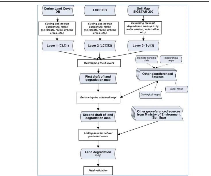
Figure 1. Flowchart showing the methodology steps and input data
CORINE Land Cover is the European reference data set for land cover. It is a flexible tool that makes it possible to measure the dynamic relationship between the many uses of the territory and their impact, as well as the conflicts resulting from the application of the different sectorial policies in agriculture, regional policy and transport. The classification system comprises 44 distinct classes grouped on 3 hierarchical levels. The satellite database that served as the foundation for the CLC2000, known as IMAGE2000, was composed of LANDSAT ETM + images.
Methodology
Analele Universităţii din Craiova, seria Agricultură – Montanologie – Cadastru (Annals of the University of Craiova - Agriculture, Montanology, Cadastre Series)Vol. XLVII 2017
166
results can be improved in a second draft map. Finally the map can be refined using specific data like special protected natural areas.
RESULTS AND DISCUSSIONS
The interrogation of land use databases shows that grassland covers 2770 ha (29%), followed by orchards 1414 ha (15%), largely extensively used. A specific situation for this hilly areas (Subcarpathian region) is represented by relatively large areas (1121 ha, 12%) of almost abandoned grassland, invaded by shrubs.
As regarding the outputs from applying the methodology, 6375 ha of agricultural lands are affected by one or more degradation processes with different intensities. The identified land degradations and natural limitation processes are water erosion, salinization, waterlogged and stagnant water from precipitation.
Statistically, 6236 ha (65%) of the output area is affected by intense water erosion processes (strong and very strong).
The excess water in soil from precipitation affects about 1746 hectares, mainly Stagni-gleyic Phaeozems. Waterlogging affect a narrower area, of only 138 ha (18%), while salinization affects only about 325 ha (3%).
a. b.
167
a. b.
Figure 3. Land use according Land Cover Classification System at LAU level (a) and for agricultural areas (b).
a. b.
Figure 4. Soil cover at LAU level (a) and for land degradation areas (b).
Analele Universităţii din Craiova, seria Agricultură – Montanologie – Cadastru (Annals of the University of Craiova - Agriculture, Montanology, Cadastre Series)Vol. XLVII 2017
168
Therefore, most of the soils are Regosols and Erodic Anthrosols, as well as Eutricambosols at different stages of degradation. Also saline soils, e.g. Solonchaks and Salic Regosols are formed due to the presence of saline deposits.
Table 1. Land degradation areas – L.A.U. Scorțoasa (Buzău county)
Code Intensity Area
ha %
Soil erosion by water
3 strong 3132.07 32.64
4 very strong 3104.07 32.35
Salinization
1 moderate 258.85 2.70
2 strong 72.27 0.75
Waterlogging
3 strong 138.52 1.44
Stagnating water
3 strong 1746.97 18.21
169
CONCLUSION
The existing geo-referenced databases (soil-terrain, land use, etc.) holds primary information which can be interogated in order to deligneate the degradated areas (by water erosion, salinisation, waterlogging, etc.) at local administrative unit (LAU) level. This assessment is a primary tool for designating potential land reclamation perimeters for agricultural lands that lost their crop production capacity. Potential areas identified by querying available databases require validation in the field.
At county or regional levels, this kind of primary assessment can support the decisions for selecting and ierarching the most affected LAUs by land degradation in order to finance land reclamation.
ACKNOWLEGMENTS
The research was performed within the framework of the Core Projects PN 16 07 01 01/2017 and PN 16 07 01 02/2016 coordinated by the National Authority for Scientific Research.
BIBLIOGRAPHY
Dumitru M., Munteanu I., 2002. State of art of land degradation and desertification in Romania – the strategy to mitigate them. International Conference on Drought Mitigation and Prevention of Land Desertification. Bled, Slovenia
Foley J. A., DeFries R., Asner G. P., Barford C. Bonan G., Carpenter S. R., et al., 2005.
Global consequences of land use. Science, 309(5734), 570e574. http:// dx.doi.org/10.1126/science.1111772.
Gibbs H.K., Salmon J.M., 2015. Mapping the world's degraded lands, Appl. Geogr., 57 (2015), pp. 12-21
Goldewijk K. K., & Verburg P. H., 2013. Uncertainties in global-scale reconstructions of historical land use: an illustration using the HYDE data set. Landscape Ecology, 28(5). Oldeman L. R., Hakkeling R. U., & Sombroek W. G., 1990. World map of the status of
human-induced soil degradation: An explanatory note. Wageningen: International Soil Reference and Information Centre.
UNCCD, 1994. UNCCD United Nations Convention to Combat Desertification in those Countries Experiencing Serious Drought and/or Desertification, Particularly in Africa. Paris, France, (1994)