Developing a field boundary evaluation and
grading system in Ireland
Marcus Collier1
and John Feehan
Department of Environmental Resource Management, Faculty of Agriculture, University College, Belfield, Dublin 4
Abstract
The purpose of this study was to develop an evaluation and grading system for the main field boundaries in Ireland – hedgerows and dry stone walls. It is shown that there is a lack of scientific information on Irish field boundaries and very little research has been carried out on what are possibly the most prominent countryside landscape features on the island. In the absence of Irish data, values were extrapolated from research in other countries. In addition, verbal consultation was carried out with prominent landscape ecologists, scientists and environmental consultants. This consultation lead to the creation of a draft survey form modeled on an earlier Hedgerow Evaluation and Grading System (HEGS) (Clements and Tofts, 1992) in the UK. The draft Irish survey, described here, is entitled the Field Boundary Evaluation and Grading System or FBEGS for short. The FBEGS was field-tested in four locations in Ireland by a number of users to obtain usefulness and accuracy. Feedback from volunteer surveyors led to an amended FBEGS survey form. This was then tested in ten locations nation-wide. Results are given and a grading system is proposed. It is shown that it may be possible to evaluate a field boundary using a simple grading system but the accuracy of such a survey cannot be confirmed due to the lack of baseline data in an Irish context. However, preliminary trial surveys indicate that values assigned to a particular boundary approximate well to professional opinion. Discussion concludes with some recommendations for continued research.
Key Index Words: Dry stone wall, FBEGS, field boundary, hedgerow, landscape management, wallrow, values.
Introduction
Since the introduction of the Rural Environment Protection Scheme (REPS) programme in 1994 agriculture in Ireland has been altered and our view of the role of the farm in the landscape has changed. The EU legislation that gave rise to the REPS, the Common Agricultural Policy (Council Regulation No. 2078/92), places on farmers the dual role of producers of agricultural goods and custodians of the rural environment (Mannion, 2001). But it is not clear how one is to gauge the success (or lack thereof) of the Scheme. Ecological monitoring and evaluation that was to be part of the REPS has not been carried out. It has been shown that, in certain ecological terms, REPS farms may not be any different than non-REPS farms and the lack of baseline data is a severe impediment
to ascertaining if conservation measures are successful (Jane Feehan et al., 2002). Measure 5 of the
REPS deals exclusively with field boundary management and conservation. This study looks exclusively at hedgerows and dry stone walls.
A conservation strategy for farm field boundaries cannot be devised unless there is accurate evaluation and grading prior to any management prescriptions. In order present arguments for hedgerow conservation in Ireland, conservation professionals often utilise functional corollaries that have been extrapolated from detailed hedgerow studies from the UK, France and other European countries. This is because it is assumed that Irish hedgerows share the same ecological significance as their European counterparts. Though most practicing ecologists agree that this is probably true, there are very little data in relation to Irish field boundaries (Smal, 1995). Using survey forms designed in other countries may not be sufficient in an Irish context as field boundaries in Ireland may differ in form, function and context. Boundary evaluations are usually based on surveyor opinion, which, in turn, reflect experience and, possibly, bias. In designing a conservation programme it is essential to have a base study with which to compare the results of any strategy. Ecological evaluation is a difficult subject and there are many ecologists with their own personal opinions as to the value of certain aspects of, in this case, field boundaries. The idea of devising a field boundary evaluation and grading system for Ireland is to begin to organize and formalise the ideas and expert opinions of those whose advice to farmers will result in the alteration of the landscape for an ecological benefit.
The four principal aims of this study were:
• To develop an objective field boundary evaluation system for Ireland
• To produce a simple, user-friendly survey for both landowner and farm advisor
• To devise a numerical grading system for hedgerow and dry stone wall field boundaries • To ensure the new survey can be integrated with the existing UK HEGS surveys
Materials and methods
Needs Analysis
In order to establish the potential usefulness of a new survey as well as to gauge the extent to which
it would be utilized a needs analysis was conducted. This needs analysis took the form of in-person
and telephone interviews with 21 professional landscape ecologists, academics and land managers taking hedgerow evaluation as a starting point. This opinion-based survey enabled a list of potential boundary attributes to be compiled. It was found that many of these attributes corresponded with the existing Hedgerow Evaluation & Grading System or HEGS (Clements & Tofts, 1992) for the hedgerow section of the FBEGS but there was no stone wall equivalent. Assumptions for walls were also made on personal experience and interviews with ecologists.
In an attempt to establish numerical values for field boundary attributes, a review of available literature was carried out. Much ecological data are available on hedgerows and very little on walls. Table 1 contains a list of key research that was used to determine initial values associated with field boundaries in Ireland.
Table 1: A survey list of the structural, ecological and cultural values of field boundaries. These values are attached to the various attributes on the FBEGS survey form.
Structural Values Ecological Values Cultural Values
Enclosure of agricultural fields in order to prevent livestock from wandering or intermingling
Morgan Evans 1994
Important wildlife corridors that provide habitat linkage
Dawson 1994
Moonen & Marshall 2001 (a & b)
Linkage to past management regimes and folk memory
Morgan Evans 1994 Oreszczyn & Lane 2000 Oreszczyn 2000
Provision of shade to livestock from the sun
Pollard et al. 1974 Greaves & Marshall 1987
Linear reserves for reptiles and amphibians
Pollard et al. 1974 Saint-Girons & Duguy 1976
Marking townland boundaries as well as parish limits
Anon 1999
Delineating property lines
Greaves & Marshall 1987 Connectivity between habitats Fry 1994 Store of medicinal plantsPodlech 1996
Provision of shelter for livestock and crops from high winds and driving rain
Pollard et al. 1974 Carborn 1976 Helps 1994
Biodiversity content
Pollard et al. 1974 Forman 1983
Forman & Baudry 1984 Burel & Baudry 1994 Smart et al.2001
Local cultural distinctiveness (walls)
Feehan 1993 McAfee 1997
Ó Maithiú & O’Reilly 1997 Brooks & Adcock 1999 Conry 2000 Fossitt 2000 Garner 2001 Screening buildings Biber 1988 Anon 1999
Plant seed reserves and genetic heritage
Pollard et al. 1974 Bunce et al. 1993 Cummins & French 1994 Smart et al. 2002
Hiding stolen objects, fugitives and to carry out illegal activities
Garda Press Office pers. comm.
Improvement of drainage
Harvey 1976 Millsopp 2001 Reif & Schmutz 2001
Importance to farm birds
Arnold 1983 Osborne 1984
O'Connor & Shrubb 1986 Lack 1992
Symbol of people’s relationship to landscape (hedgerows)
Pollard et al. 1974 Green 1981
Oreszczyn & Lane 2000
Interception of agricultural spray drift
Moonen & Marshall 2001 (a & b)
Vascular plant reserves
Helliwell 1975 Bunce et al. 1994a Wilson 1994 McCollin et al. 2000
Amenity and hunting
Rands & Sotherton 1987 Aebischer et al. 1994 Anon 1996
Reducing soil blow
Pollard et al. 1974 Fry 1994 An Taisce 2000
Importance for small mammals
Pollard et al. 1974 Poulton 1994 Tew 1994
To provide food for humans and livestock
Reif & Schmutz 2001
Flood and erosion buffers
Greaves & Marshall 1987 Mériot 1999
An Taisce 2000
Shelter for overwintering and predator invertebrates
Holland, et al. 2001
Provision of craft materials
Baudry et al. 2000
Maclean 2000 & pers. comm. Baudry & Bunce, 2001
Prevention of wetland pollution from runoff
Vought et al. 1995 Viaud et al. 2001 Borin & Bigon 2002 Mezzalira pers. comm.2
Shelter for pollinating invertebrates
Lewis 1965 Pollard et al. 1974 Dover & Sparks 2000 Moreby & Southway 2001
Dividing soil types and thus cropping patterns
Maclean 2000 Dowdswell 1987 Rackham 1986
Limiting evapotranspiration
Pollard et al. 1974 Biber 1988 An Taisce 2000
Fungi reserves
Montégut 1976 Dowdswell 1987
Protecting livestock and property from theft or sabotage
Kelly 1997
Increasing local precipitation
Biber 1988
Lichens and mosses (walls)
Darlington 1981 Carr & Bell 1991 Pilcher & Hall 2001
Provision of wood fuel
An Taisce 2000 Biber 1988 Baudry et al. 2000
Improvement of crop yields
Biber 1988
Local microclimate
Guyot & Verbrugghe 1976
2 Dr. Giustino Mezzalira, Veneto Agricoltura (a regional counterpart to Teagasc in Italy). Personal communication with
Pilot Test with Draft Instrument 1
A pilot trial using a draft of the FBEGS survey form was carried out. This was to test the survey form and to identify any shortfalls and significant problems. The trial was also intended to test the assigned attribute values and to examine if there is any correlation between these values and the perceived value of the boundary. It was carried out in early July 2002 in the following locations:
Location A Balbriggan, Co. Dublin
Location B Ballinabracky, Co. Westmeath Location C Ballyknockan, Co. Wicklow Location D Tallaght, Co. Dublin
In total twenty-eight (28) boundaries were surveyed; eighteen (64%) were hedgerows and ten (36%) were dry stone walls. The locations were chosen for their familiarity with the landowners, but the individual boundaries were chosen at random. When completing the survey form, the surveyor selected an attribute on the survey sheet that best matched the particular attribute of the field boundary. A numerical score is allocated for the various attributes. This yielded an overall score at the end of the survey. This score was then used to identify the ecological value of that field boundary.
The surveyor had to follow a simple guide on how to fill out the survey form. This guide was verbally conveyed. Three surveyors carried out the first field tests of the FBEGS. Two surveyors had experience in using the HEGS survey form and were familiar with the attributes under examination. The third surveyor had never carried out a survey of this kind but was an experienced ecologist. All three carried out the FBEGS survey on the same twenty-eight boundaries independently of each other. Upon completion of the survey the data were gathered and compared to the surveyor’s personal opinion of the boundary in question. The surveyors also gave their opinions on the user-friendliness of the form and other helpful comments.
Test with Draft Instrument 2
With the response of surveyors, opinions of other professionals and further research, the FBEGS survey form was adjusted to its current format. This survey was an A3 page that could be folded in half (A4) for practical usage in the field. On side 1 is the survey form itself. Side 2 contains a list of common field boundary tree and woody shrub species and suggested abbreviations as well as some
hints for filling the form out. The FBEGS form has five basic sections:
• Structure (attributes 1 to 7)
• Associated Features (attributes 8 to 11) • Connectivity (attributes 12 to 16) • Diversity (attributes 17 and 18) • Overall Type (attributes 19 to 21)
This is a total of 21 attributes in all, each of which is described using an icon or a written description. Not all attributes need to be completed and some are mutually exclusive of each other. Each of the five sections has a ‘sub total’ box at the end and the entire survey is a summing of the five ‘sub-totals’. Illustration 1 shows side one of the survey form and Illustration 2 shows the reverse of the form. This is the survey sheet currently available for use.
Balbriggan, Co. Dublin
Ballinabracky, Co. Westmeath Ballyknockan, Co. Wicklow Clonmel, Co. Tipperary Kilbeggan, Co. Westmeath Rossinver, Co. Leitrim Croghan, Co. Roscommon Tallaght, Co. Dublin Tralee, Co. Kerry Westport, Co. Mayo
These locations were chosen in order to gather information in as wide a variety of locations as was possible given the very limited time available. The type of field boundary surveyed in each location was chosen at random. Each survey took an average of 20 to 30 minutes to complete but inclement weather for the time of year impeded many of the surveys and thus only a relatively small number of boundaries (100) could be surveyed. Prior to the start of each survey, the surveyor would note their professional opinion as to the ecological value of the field boundary based on their professional knowledge and experience in landscape assessment. The surveyor indicated their opinion of the ecological value of the boundary on the top of the survey form using one of the following annotations: ‘High’, ‘Moderate’, ‘Low’, ‘None’. Consultation with the landowner was avoided as this may have impeded the survey and created a bias the surveyor. The surveyors were volunteers and consisted of professional ecologists, REPS planners, third level students and other experienced volunteers.
At the same time, the older HEGS UK survey was also completed for those field boundaries that were classed as hedgerows (60). There is no equivalent survey for dry stone walls. For hedgerows, the completed HEGS and the new FBEGS were attached and submitted together for compilation. In order to accelerate the pace of surveys in the time allotted the title attributes of Altitude, Slope and Soil Type were not completed. These do not have any bearing on the overall grade of the boundary as the survey form now stands and are merely for statistical purposes. Out of the 100 boundaries selected 79 surveys were completed correctly. 21 (27%) were later judged to have been carried out incompletely and 4 (5%) were discarded due to indecisiveness on the part of the surveyor or illegibility. This left 54 completed surveys of field boundaries – 24 (44%) were dry stone walls (numbers 1 to 24) and 30 (56%) were hedgerows (boundary numbers 25 to 54). The surveyors did not calculate or compile the numerical results themselves. All survey forms were analysed in the absence of the surveyors.
Results
Needs Analysis
The needs analysis poll overwhelmingly demonstrated that an Irish hedgerow evaluation survey
was very necessary but that it should address field boundaries and not just hedgerows. This was
mainly because the description of hedgerows derived from other countries was not necessarily suited to what most people consider a hedgerow in Ireland and that stone wall boundaries may have ecological values hitherto undefined or unexplored. Nearly all of the respondents agreed that the new survey would be useful and desirable and most suggested that it may be based on an earlier Hedgerow Evaluation & Grading System or HEGS (Clements & Tofts, 1992) both in form and simplicity of use. Though slightly amended version of the HEGS form is currently in use by REPS
planners (Anon, 2001; Catherine Keena – Teagasc Training Centre, Kildalton, Co. Carlow, pers.
comm.), it was felt that an amended HEGS would be better suited to Irish field boundaries. It might
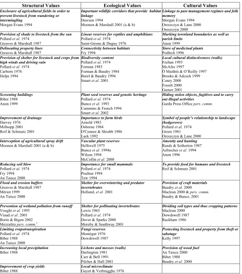
Table 2 is a list of the main attributes that the needs analysis survey reveled as potential inclusions in a new survey.
[image:6.595.90.500.111.237.2]
Table 2: Suggested inclusions for a new field boundary survey.
Subject Respondents who felt this should be included
Adjacent land use 21 100%
Type of boundary 20 95%
Stone walls 18 86%
Orientation to wind 17 81%
Slope and aspect 16 76%
Altitude 16 76%
Soil type 15 71%
Dead wood estimation 13 62%
Stone-faced embankments 12 57%
Post and rail fences 2 9.5%
Wire fences 1 5%
In addition, nineteen respondents (91%) wished to see an expanded section dealing with standard trees. The current HEGS survey sheet merely asks for “mature” or “young” standards. This can be misleading and subjective. As there are little available data on the native or non-native woody shrub content of Irish hedgerows it was felt by almost all respondents (81%) that an attempt to gather such data should be made. A new survey could offer an opportunity for the initial collection of such data and having a standard survey form may facilitate a possible compilation survey in the future. Some of those polled thought that a question on the volume of dead wood in the boundary was important but did not have an opinion on how such a question would be phrased or such an attribute should be calculated. Six respondents (29%) said that the HEGS attribute for rare and notable species should be removed as it was not relevant to Irish hedgerows. As a result of this consultation, a list of fifteen guide points were drawn up and used to inform the shape and style of the survey. These points are shown in Table 3.
Table 3: List of guide-points used in preparing the Field Boundary Evaluation and Grading System (FBEGS).
The FBEGS should:
• Focus on hedgerows and dry stone wall field boundaries and not just hedgerows alone
• Record altitude, slope and soil type for future reference and statistical purposes
• Use a simple numerical grading system
• Use an expanded icon system similar to the HEGS
• Use similar criterion for gaps, connectivity and other HEGS attributes shown to be of importance in UK research
• Include a tree and woody species list and some information on completion of those attributes when in the field
• Include adjacent land use, dead wood and drain type
• Include an attribute on boundary orientation to the prevailing wind and slope
• Include stone-faced embankments separate to earthbanks
• Not seek information on rare or notable species
• Not attempt to identify regional variation
• Not estimate the age of the boundary
• Omit other boundaries such as wire fences, motorway medians, new or young boundaries and domestic boundaries
• Avoid the use of the word ‘ditch’ or any colloquialisms
• Be easy to read in the field and as short and to the point as possible
• Fit on one page or two A4 pages on an A3 page folded to A4 size
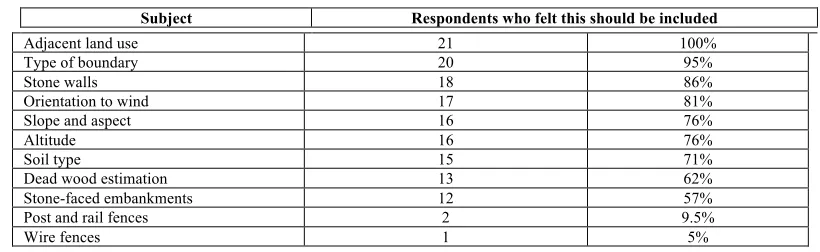
Pilot Test with Draft Instrument 1
Table 4: Comparison of surveyors scores for the FBEGS pilot test.
Boundary No. Boundary type Location Surveyor 1 Scores Surveyor 2 Scores Surveyor 3 Scores
1 Hedgerow D 49 50 50
2 Hedgerow D 48 49 48
3 Hedgerow D 48 48 49
4 Hedgerow D 50 52 54
5 Hedgerow B 55 55 60
6 Hedgerow B 22 25 26
7 Hedgerow D 34 34 36
8 Hedgerow D 26 25 28
9 Hedgerow D 38 39 44
10 Hedgerow B 41 44 42
11 Hedgerow C 18 20 21
12 Hedgerow B 65 66 63
13 Hedgerow B 56 54 58
14 Hedgerow B 58 57 59
15 Hedgerow A 48 47 45
16 Hedgerow A 32 34 35
17 Hedgerow A 61 59 56
18 Hedgerow A 46 45 49
19 Wall C 31 30 31
20 Wall C 32 32 34
21 Wall C 23 27 26
22 Wall C 23 25 30
23 Wall C 12 16 14
24 Wall C 14 15 12
25 Wall C 19 18 19
26 Wall A 28 28 23
27 Wall A 19 19 14
28 Wall A 20 19 17
FBEGS Draft 1 - Hedgerow
0 10 20 30 40 50 60 70
1 2 3 4 5 6 7 8 9 10 11 12 13 14 15 16 17 18
Hedgerow Number
FBEGS
Score
[image:7.595.63.530.416.749.2]Surveyor 1 Surveyor 2 Surveyor 3
FBEGS Draft 1 - Stone Walls
0 5 10 15 20 25 30 35 40
1 2 3 4 5 6 7 8 9 10
Wall Number
FBEGS Score
[image:8.595.61.530.71.395.2]Surveyor 1 Surveyor 2 Surveyor 3
Figure 1b: Comparison of FBEGS pilot test surveyor results for dry stone walls.
Test with Draft Instrument 2
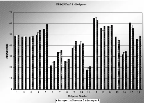
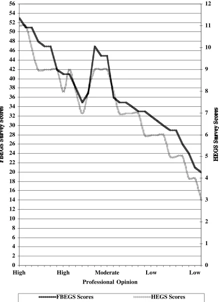
[image:8.595.167.427.546.778.2]Table 5 contains the results of the expanded test and Figure 2 shows the correlation between surveyor’s opinion and the FBEGS scores for dry stone wall field boundaries. Table 6 contains the results and Figure 3 shows the correlation between surveyor’s opinions and FBEGS scores for hedgerow field boundaries. Figure 4 shown the comparison between the two survey results (FBEGS and HEGS) and professional opinion for hedgerow field boundaries.
Table 5: Survey results for dry stone wall field boundaries.
Location Boundary no.
Initial opinion
FBEGS score
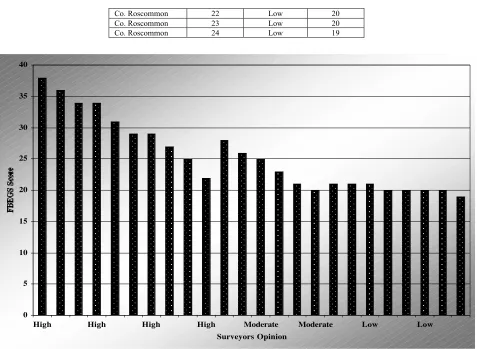
Co. Wicklow 1 High 38
Co. Roscommon 2 High 36
Co. Wicklow 3 High 34
Co. Wicklow 4 High 34
Co. Wicklow 5 High 31
Co. Westmeath 6 Moderate 28
Co. Westmeath 7 High 29
Co. Wicklow 8 High 29
Co. Leitrim 9 High 27
Co. Wicklow 10 Moderate 26
Co. Mayo 11 High 25
Co. Mayo 12 Moderate 25
Co. Wicklow 13 Moderate 23
Co. Kerry 14 High 22
Co. Kerry 15 Low 21
Co. Kerry 16 Low 21
Co. Mayo 17 Low 21
Co. Wicklow 18 Moderate 21
Co. Wicklow 19 Moderate 20
Co. Mayo 20 Low 20
Co. Roscommon 22 Low 20
Co. Roscommon 23 Low 20
Co. Roscommon 24 Low 19
0 5 10 15 20 25 30 35 40
High High High High Moderate Moderate Low Low
Surveyors Opinion
[image:9.595.61.538.49.398.2]FBEGS Score
Figure 2: Correlation between surveyor’s opinion and FBEGS scores for dry stone wall field boundaries.
Table 5: Survey results for hedgerow field boundaries.
Location Boundary
no.
Initial opinion
FBEGS score
HEGS score
Teagasc Score*
Co. Dublin 25 High 53 1 11
Co. Dublin 26 High 51 1 11
Co. Tipperary 27 High 51 -1 10
Co. Tipperary 28 High 48 2+ 9
Co. Kerry 29 High 47 2+ 9
Co. Dublin 30 Moderate 47 2+ 9
Co. Dublin 31 High 47 2+ 9
Co. Kerry 32 Moderate 45 2+ 8
Co. Kerry 33 Moderate 45 2+ 9
Co. Westmeath 34 High 42 2+ 8
Co. Westmeath 35 High 41 2 7
Co. Tipperary 36 High 41 2+ 8
Co. Leitrim 37 High 38 2 9
Co. Westmeath 38 High 37 2 9
Co. Wicklow 39 Moderate 36 2 9
Co. Wicklow 40 Moderate 35 -2 8
Co. Wicklow 41 High 35 -2 7
Co. Westmeath 42 Low 35 -2 7
Co. Kerry 43 Low 34 -2 7
Co. Kerry 44 Low 33 -2 7
Co. Kerry 45 Low 33 3+ 6
Co. Kerry 46 Low 32 3+ 6
Co. Westmeath 47 Low 31 3+ 6
Co. Westmeath 48 Low 30 3+ 6
Co. Leitrim 49 Low 29 3 5
Co. Westmeath 50 Low 29 3 5
Co. Dublin 51 Low 26 3 5
Co. Leitrim 52 Low 24 (-)3 4
Co. Tipperary 53 Low 21 -3 4
[image:9.595.96.499.451.774.2]* In order to be able to compare data it was necessary to alter the HEGS scoring system slightly. This entailed the usage of a 1 to 12 score similar to the one used by Teagasc (Anon, 2001).
0 10 20 30 40 50 60
High High High High Moderate Moderate Low Low Low Low
Surveyors Opinion
[image:10.595.62.537.86.412.2]FBEGS Scores
0 2 4 6 8 10 12 14 16 18 20 22 24 26 28 30 32 34 36 38 40 42 44 46 48 50 52 54 56
High High Moderate Low Low
Professional Opinion
FBEGS Survey Scores
0 1 2 3 4 5 6 7 8 9 10 11 12
HEGS Survey Scores
[image:11.595.77.516.73.678.2]FBEGS Scores HEGS Scores
Discussion
Needs Analysis and Pilot Test with Draft Instrument 1
Results from the initial phase of this study demonstrate that there was a need for a practical and objective field boundary evaluation and grading system. The similarity of scores shown in Figure 1 illustrates clearly the desired objectivity and that the selected attributes and their corresponding scoring values were sufficiently accurate. Feedback from surveyors was positive and most indicated that the survey was user-friendly and practical. This was also an aim of the study but further testing will be needed to confirm if this second aim of the study has actually been achieved.
Test with Draft Instrument 2
The second and larger FBEGS trial confirms that there is good correlation between surveyor’s opinion and FBEGS scores for both hedgerows and dry stone walls. Tables 4 and 5 show that, as the opinion of the surveyor increases from ‘low’ to ‘high’ so too does the FBEGS score. Where the surveyors’ opinion is that the field boundary is of ‘low’ ecological value the score values are low in comparison to the higher score values where the surveyor has indicated that the field boundary is of ‘high’ value. One area where the surveyors’ opinion and the scores deviate slightly is where the assessment is “moderate”. There are some inconsistencies in the scores at the centre of both graphs (figures 2 and 3). This is to be expected and it is not to be assumed that the scores are unreflective of the value of the field boundary. Professional opinion may often be variance and that this is in the nature of such subjective, opinion-based surveys. This is a consistent finding where values are to be decided upon. In the case of hedgerow field boundaries there appears to be a high level of agreement. This was also noted at the time of the development of the HEGS survey (Tofts & Clements, 1994). In the case of dry stone wall field boundaries there is good agreement also, but opinions appear to be more disparate. The results indicate that the attributes allocated to each section of the FBEGS survey form were appropriate though a more thorough and larger trial may be necessary to confirm this.
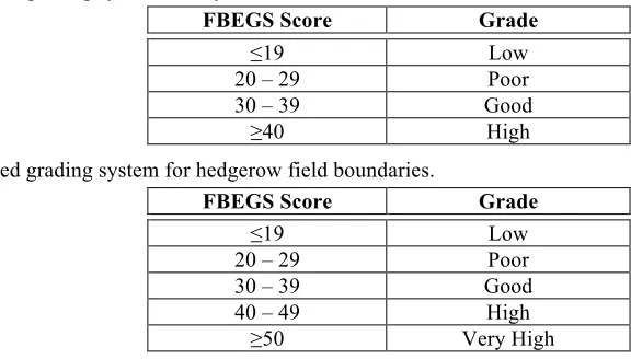
[image:12.595.120.408.537.701.2]It is not be appropriate to include both field boundaries in the same grading system despite their similarity. It will also be necessary to carry out more detailed field research so the exact grades can be confirmed. Therefore, based on the results acquired during the sample field tests of the FBEGS, two grading systems are proposed. It is now possible to propose an evaluation grading system as is shown in Tables 6 and 7.
Table 6: Proposed grading system for dry stone wall field boundaries.
Table 7: Proposed grading system for hedgerow field boundaries.
FBEGS Score Grade
≤19 Low
20 – 29 Poor
30 – 39 Good
40 – 49 High
≥50 Very High
The scores acquired in the FBEGS test surveys can be compared to the HEGS scores with little difficulty, but only in the case of hedgerows for which the HEGS survey was exclusively designed. From the FBEGS grades indicated in Table 7 it is shown that there is a corresponding HEGS value of a similar grade. This implies that, in the case of hedgerow data, the two surveys are compatible. The demonstration of this compatibility was one of the main aims of this study as it may now be
FBEGS Score Grade
≤19 Low
20 – 29 Poor
30 – 39 Good
possible to compare data from Ireland to data acquired in the UK. Table 8 shows the overlap of the two grading systems adjusted to make the two surveys compatible.
Table 8: Compatibility between HEGS and FBEGS survey grades.
FBEGS Score Grade HEGS Score
≤19 Low -4 to 4+
20 – 29 Poor -3 to 3+
30 – 39 Good -2 to 2
40 – 49 High 2+ to -1
≥50 Very High 1 to 1+
Conclusion
There are some difficulties associated with the FBEGS grades. Initially, the correlation between field boundaries of high value in the opinion of the surveyor and the high scores of the survey (and visa versa for the low scores) may presuppose accuracy in the grading system. However, in the absence of scientific studies to confirm or refute the findings, this is not possible. Indeed, since there are little data on the ecological values of Irish field boundaries, it could be a long time before the FBEGS can be confirmed or even refined to be more accurate or appropriate. With this said, it is a contention that the FBEGS is a good indicator of where to begin and in basic conservation management assessment this survey is sufficient. The grading system by the FBEGS can be used, for example, by REPS assessors and farmers in deciding upon the value of a particular boundary and thus in devising conservation management prescriptions for that boundary. Having a physical database of survey sheets also means that the surveyor can return in time and re-assess any boundary using the same survey form. In the case of REPS planners, the FBEGS data may then be utilised to check on conservation management progress and respond accordingly. Linking the data of the survey to a GIS database may even be used in relation to payments for conservation activities. Having an Irish survey that is compatible with the UK HEGS survey might also be of assistance in cross-comparison studies.
There is no doubt that the lack of published information on the ecological values of hedgerows and dry stone walls in Ireland detracts significantly from this study. The ecological value of stone walls is unknown, even among professionals, but without data the debate cannot continue. Ecologists and conservationists appear to take more interest in hedgerows yet, in Ireland, little evidence exists as to their value to, and function in, the Irish landscape. The same might also be said for earthen and stone-faced embankment field boundaries. However, it has been shown that the FBEGS survey is a starting point as well as a sufficient interim survey for day-to-day landscape management and assessment.
Recommendations
This study was carried out by using some assumptions and opinions of professionals. This makes the FBEGS survey function practically and up to a certain point. However, if further qualitative research is to be continued more information and data are required. The key recommendations of this dissertation are:
• The lack of information and data relating to Irish field boundaries should be addressed
• The use of ecological field surveys to test FBEGS results is urgently required
• Detailed information on field boundary types and status in Ireland is necessary
• The ecological values of dry stone walls should be established
• Large scale testing of FBEGS is necessary and can only be brought about by its adoption on a
Acknowledgements
We would like to thank all the professional landscape ecologists, REPS planners and conservation specialists for their input and feedback. In addition, the assistance and diligence of the volunteer surveyors is greatly appreciated.
References
Aebischer, N.J., Blake, K.A. & Boatman, N.D. (1994) Field margin habitats for game. In: N.
Boatman (Ed.) Field Margins: Integrating Agriculture and Conservation. (BCPC Monograph, #58)
95 – 104.
Anon (1996) Hedges and Fields for Shooting and Conservation. British Association for Shooting
and Conservation, Wrexham, UK.
Anon (1999) The Good Hedge Guide. Farming and Wildlife Advisory Group (FWAG), Bayer Ltd,
UK.
Anon (2001) Farming and the Environment Workbook. Teagasc, Curriculum Development Unit,
Piltown, Kilkenny.
An Taisce (2000) Trees, Hedges and Water. An Taisce, Dublin.
Arnold, G.W. (1983) The influence of ditch and hedgerow structure, length of hedgerows, and area
of woodland and garden on bird numbers on farmland. Journal of Applied Ecology, 20, 731 – 50.
Baudry, J. & Bunce, R.G.H. (2001) An overview of the landscape ecology of hedgerows. In: C.
Barr & S. Petit (Eds.) Hedgerows of the world: their ecological functions in different landscapes.
(IALE, UK), 3 – 16.
Baudry, J., Bunce, R.G.H. & Burel, F. (2000) Hedgerows: An international perspective on their
origin, function and management. Journal of Environmental Management, 60, 7 – 22.
Biber, J-P. (1988) Hedges. Planning and Management Series, No. 1. Council of Europe, Strasbourg.
Borin, M. & Bigon, E. (2002) Abatement of NO3-N concentration in agricultural waters by narrow
buffer strips. Environmental Pollution, 117, 165 – 8.
Brooks, A. & Adcock, S. (1999) Dry Stone Walling: a Practical Handbook. British Trust for
Conservation Volunteers, UK.
Bunce, R.G.H., Howard, D.C., Barr, C.J., Cummins, R.C. & French, D. (1994) Botanical diversity
in British hedgerows. In: N. Boatman (Ed.) Field Margins: Integrating Agriculture and
Conservation. (BCPC Monograph, #58) 43 – 52.
Bunce, R.J.H., Howard, D.C., Hallam, C.J., Barr, C.J. & Benefield, C.B. (1993) Ecological
Consequences of Land Use Change. Institute of Terrestrial Ecology report for the Department of the Environment, HMSO, London.
Burel, F. & Baudry, J. (1994) Control of biodiversity in hedgerow network landscapes in western
France. In: T.A. Watt & G.P. Buckley (Eds.) Hedgerow Management and Nature Conservation.
(Wye College Press, UK), 47 – 57.
Carborn, J.M. (1976) landscape changing and protection against the wind. Les Bocages, Histoire,
Economie, Ecologie3, (Rennes, France), 109 – 14.
Carr, S. & Bell, M. (1991) Practical Conservation: Boundary Habitats. The Open University,
Hodder & Stoughton, London.
Clements, D.K. & Tofts, R.J. (1992) Hedgerow Evaluation and Grading System (HEGS), Test
Draft. Countryside Planning and Management, Gloucestershire, UK, 1 – 61.
Conry, M.J. (2000) The Carlow Fence: Traditional Granite Fencing & Dry Stone Walling in
County Carlow. Chapeltown Press, Carlow.
Cummins, R. & French, D. (1994) Floristic diversity, management and associated land use in
British hedgerows. In: T.A. Watt & G.P. Buckley (Eds.) Hedgerow Management and Nature
Conservation. (Wye College Press, UK), 95 – 106.
Darlington, A. (1981) The Ecology of Walls. Heinmann, UK.
Dawson, D. (1994) Are Habitat Corridors Conduits for Animals and Plants in a Fragmented
Landscape? A Review of the Scientific Evidence. English Nature, UK.
Dover, J.W. & Sparks, T. (2000) A review of the ecology of butterflies in British hedgerows.
Journal of Environmental Management, 60, 51 – 63.
Dowdswell, W.H. (1987) Hedgerows and Verges. Allen & Unwin, London.
Feehan, Jane, Gilmore, D.A. & Culleton, N.E. (2002) The impact of the Rural Environment
Protection Scheme (REPS) on plant and insect diversity. In: J. Feehan (Ed.) Tearmann: The Irish
Journal of Agri-environmental Research. (Faculty of Agriculture, UCD, Dublin), 2, 15 – 28.
Feehan, J. & Keena, C (2001) Irish hedges and ditches: some guidelines for management. In: J.
Feehan (Ed.) Tearmann: The Irish Journal of Agri-environmental Research. (Faculty of
Agriculture, UCD, Dublin), 1, 79 – 94.
Feehan, J. (Ed.) (1991) Environment and Development in Ireland. Conference Proceedings.
University College Dublin, Dublin.
Feehan, J. (1993) Traditional Architecture: Its role in rural development and community tourism.
In: B. Ní Fhloinn & G. Dennison (Eds.) Traditional Architecture in Ireland and its role in rural
development and tourism. Environmental Institute, University College Dublin, Dublin, 87 – 94. Forman, R.T.T. & Baudry, J. (1984) Hedgerows and hedgerow networks in landscape ecology.
Environmental Management, 8, 499 – 510.
Forman, R.T.T., (1983) Corridors in a landscape: their ecological structure and function. Ecology
(CSSR), 2, 375 – 87.
Fossitt, J. A. (2000) A Guide to Habitats in Ireland. The Heritage Council, Kilkenny.
Fry, G.L.A. (1994) The role of field margins in the landscape. In: N. Boatman (Ed.) Field Margins:
Integrating Agriculture and Conservation. (BCPC Monograph, #58) 31 – 40.
Garner, L. (2001) Dry Stone Walls. Shire Publications, Risborough, Bucks, UK.
Greaves, M.P. & Marshall, E.J.P. (1987) Field margins: definitions and statistics. In: J.M. Way &
P.W. Greig-Smith (Eds.) Field Margins. (BCPC Monograph, #35), 3 – 8.
Green, B. (1981) Countryside Conservation. George Allen & Unwin, London, UK.
Guyot, G. & Verbrugghe, M.(1976) Étude de la variabilité spatiale du microclimat à l’échelle
parcellaire en zone bocagère. Les Bocages, Histoire, Economie, Ecologie, (Rennes, France), 131 –
6.
Harvey, N. (1976) Fields, Hedges and Ditches. Shire Publications, Risborough, Bucks, UK.
Helliwell, D.R., (1975) The distribution of woodland plant species in some Shropshire hedgerows.
Biological Conservation, 7, 61 – 72.
Helps, M.B. (1994) Field margins: an agricultural perspective. In: N. Boatman (Ed.) Field Margins:
Integrating Agriculture and Conservation. (BCPC Monograph, #58) 21 – 30.
Holland, J.D., Begbie, M., Birkett, T., Reynolds, C.J.M., Thomas, C.F.G. (2001) The influence of hedgerows on coleopteran distributions: results from a multi-field sampling study. In: C. Barr & S.
Petit (Eds.) Hedgerows of the world: their ecological functions in different landscapes. (IALE,
UK), 177 – 86.
Kelly, F. (1997) Early Irish Farming. Early Irish Law Series, IV, School of Celtic Studies, Dublin.
Lack, P. C. (1992) Birds on Lowland Farms. HMSO, London.
Lewis, T. (1965) The distribution of insects near a low hedgerow. Journal of Applied Ecology, 6,
443 – 52.
Maclean, M. (2000) Resource Management: Hedges. Farming Press, Tonbridge, UK.
Mannion, J., Gorman, M. & Kinsella, J. (2001) Connecting farming, the environment and society: a
living countryside perspective. In: J. Feehan (Ed.) Tearmann: The Irish Journal of
Agri-environmental Research. (Faculty of Agriculture, UCD, Dublin), 1, 11 – 17.
McAfee, Patrick (1997) Irish Stone Walls. O’Brien Press, Dublin.
McCollin, D., Jackson, J.J., Bunce, R.G.H., Barr, C.J., Stuart, R. (2000) Hedgerows as habitat for
Mériot, P. (1999) The influence of hedgerow systems on the hydrology of agricultural catchments
in a temperate climate. Agronomie, 19, 655 – 69.
Millsopp, C. (2001) Restoration of Hedges and Walls. Greenmount College, 29/A/01, Report to
DARDNI, UK.
Montégut, J. (1976) Le bocage et les champignons des sous bois. Les Bocages, Histoire, Economie,
Ecologie, (Rennes, France), 239 – 45.
Moonen, A.C. & Marshall E.J.P. (2001a) Field margins in northern Europe: their functions and
interactions with agriculture. Agriculture, Ecosystems & Environment, 89, 1 – 17.
Moonen, A.C. & Marshall E.J.P. (2001b) The influence of sown margin strips, management and boundary structure on herbaceous field margin vegetation in two neighbouring farms in southern
England, Agriculture, Ecosystems & Environment, 86, 187 – 202.
Moreby, S.J. & Southway, S. (2001) The importance of hedgerow field boundaries to densities of
beneficial invertebrates in cereals. In: C. Barr & S. Petit (Eds.) Hedgerows of the world: their
ecological functions in different landscapes. (IALE, UK), 213 – 8.
Morgan Evans, D. (1994) Hedges as historic artifacts. In: T.A. Watt & G.P. Buckley (Eds.)
Hedgerow Management and Nature Conservation. (Wye College Press, UK), 107 – 18.
Ó Maithiú, S. & O’Reilly, B (1997) Ballyknockan: A Wicklow Stonecutters Village. Woodfield
Press, Dublin.
O’Connor, R.J. & Shrubb, M. (1986) Farming and Birds. Cambridge University Press, UK.
Osborne, P. (1984) Bird numbers and habitat characteristics in farmland hedgerows. Journal of
Applied Ecology, 6, 63 – 82.
Oreszczyn, S. (2000) A systems approach to the research of people’s relationships with English
hedgerows. Landscape & Urban Planning, 50, 107 – 17.
Oreszczyn, S. & Lane, A. (2000) The meaning of hedgerows in the English landscape: Different
perspectives and implications for future hedge management. Journal of Environmental
Management, 60, 101 – 18.
Pilcher, J. & Hall V., (2001) Flora Hibernica: the wild flowers, plants and trees of Ireland. Collins
Press, Wilton, Cork.
Podlech, D. (1996) Herbs and Healing Plants of Britain and Europe. Collins, London.
Pollard, E., Hooper, M.D. & Moore, N.W. (1974) Hedges. Collins, London.
Poulton, S.M.C. (1994) Small mammal populations in hedgerows: the relationship with seed and
berry production. In: N. Boatman (Ed.) Field Margins: Integrating Agriculture and Conservation.
(BCPC Monograph, #58) 133 – 8.
Rackham, O. (1986) The History of the Countryside. Dent, London.
Rands, R.W. & Sotherton, N.W. (1987) The management of field margins for the conservation of
gamebirds. In: J.M. Way & P.W. Greig-Smith (Eds.) Field Margins. (BCPC Monograph, #35), 95 –
104.
Reif, A. & Schmutz, T. (2001) Planting and Maintaining Hedges in Europe. Institut pour le
Développement Forestier (IDF), Rennes, France.
Saint-Girons, H. & Duguy, R. (1976) Les reptiles du bocage. Les Bocages, Histoire, Economie,
Ecologie, (Rennes, France), 347 – 49.
Smal, C. (1995) The Badger and Habitat Survey of Ireland. Office of Public Works and Department
of Agriculture and Rural Development, Dublin.
Smart, S.M., Bunce, R.G.H. & Stuart, R.C. (2001) An assessment of the potential of British hedges to act as corridors and refuges for Ancient Woodland Indicator plants. In: C. Barr & S. Petit (Eds.)
Hedgerows of the world: their ecological functions in different landscapes. (IALE, UK), 137 – 46. Smart, S.M., Bunce, R.G.H., Firbank, L.G. & Coward, P. (2002) Do field boundaries act as refugia for grassland plant species diversity in intensively managed agricultural landscapes in Britain?
Agriculture, Ecosystems & Environment, 91, 73 – 87.
Tew, T.E. (1994) Farmland hedgerows: habitat, corridors or irrelevant? A small mammal
perspective. In: T.A. Watt & G.P. Buckley (Eds.) Hedgerow Management and Nature
Tofts, R.J. & Clements, D.K. (1994) The development and testing of HEGS, a methodology for the
evaluation and grading of hedgerows. In: N. Boatman (Ed.) Field Margins: Integrating Agriculture
and Conservation. (BCPC Monograph, #58) 277 – 82.
Viaud, V., Caubel, V., Grimaldi, C., Baudry, J. & Mérot (2001) The influence of hedgerow systems on water and pollution fluxes: from the local to the catchment scale. In: C. Barr & S. Petit (Eds.)
Hedgerows of the world: their ecological functions in different landscapes. (IALE, UK), 281 – 7. Vought, L.B.M., Pinay, G., Fuglsang, A. & Ruffononi, C. (1995) Structure and function of buffer
strips from water quality perspectives in agricultural landscapes. Landscape & Urban Planning, 31,
323 – 31.
Wilson, P.J. (1994) Botanical diversity in arable field margins. In: N. Boatman (Ed.) Field
Illustration 1: The FBEGS survey form – side 1
FIELD BOUNDARY EVALUATION AND GRADING SYSTEM (FBEGS) – DRAFT SURVEY SHEET
Survey Grid: Boundary Number: Name: Date: Altitude: Slope: Soil Type: Boundary Length (m)
BOUNDARY STRUCTURE
1) Boundary type is: a. A dry stone wall
b. A recently coppiced or laid hedgerow
c. A hedgerow that is severely flailed to within 1m of the ground
Yes or No Yes or No Yes or No
If yes, score 3 and ignore questions 2 and 3 - if no go to 2 If yes, score 9 and ignore questions 2 to 4 - if no go to 2 If yes, score 1 and ignore questions 2 and 3 - if no go to 2
SCORE 1 2 3 4 5
2) Average HEIGHT: .5m to 1m 1m to 2m 2m to 3m 3m to 4m >4m 3) Average WIDTH at base: .5m to 1m 1m to 2m 2m to 3m 3m to 4m >4m 4) Average CROSS-SECTION:
HEDGEROW
DOUBLE-SIDED DRY STONE WALL
SINGLE DRY STONE WALL
STONE FACED EMBANKMENTS
Standard Tree Species Checklist and Size - L = > 50cm dbh / M= 20 – 50cm dbh / S = <20cm dbh (for abbreviations consult species list overleaf)
Total Number of Standard Tree Species per 100m:
SCORE 1 2 3 4 5
5) LARGE Trees / 100m: >1.4 1.5 - 2.5 2.6 – 3.5 3.5 – 4.5 >4.6 6) MEDIUM Trees / 100m: >1.4 1.5 - 2.5 2.6 – 3.5 3.5 – 4.5 >4.6 7) SMALL Trees / 100m: >1.4 1.5 - 2.5 2.6 – 3.5 3.5 – 4.5 >4.6
TOTAL STRUCTURAL SCORE:
ASSOCIATED FEATURES OF THE BOUNDARY
SCORE 1 2 3 4 5
8) Earthbank Height: <1m 1 – 1.5m 1.5 – 2m >2m 9) Drain:
(If there is no drain go to question 10.) Note 'B' = Boundary as noted by you in 4.
10) Field Margin (>2m): <2m 1 Side Cut 2 Sides Cut 1 Side Un-cut 2 Sides Un-cut 11) Agricultural or other activities for up
to 20m on either side of the boundary: Domestic GardenRoad Industry School Silage Cereals Sheep Grazing Quarry Plantation Forestry (>20 ya) Cattle Grazing Horticulture Unused Orchard Derelict Land Amenity
Mature or Mixed Broadleaved Forestry (>50 ya)
Nature Reserve TOTAL ASSOCIATED FEATURES SCORE:
BOUNDARY CONNECTIVITY
SCORE 1 2 3 4 5
12) Percentage of GAPS: >30% 10 – 30% 5 – 10% Up to 5% None 13) Boundary to hedgerow connectivity: 1 2 3 4 14) Boundary to wall connectivity: 1 2 3 4
15) Boundary to other natural or
semi-natural habitats connectivity: RailwayQuarry Mature PlantationForestry Parkland
Bog / Heath Marsh / Mire Scrub / Fen
Stream / River Canal Lake / Pond
Mature and Mixed Broadleaved
Woodland 16) Parallel boundary within 15 m: Earthbank Dry Stone Wall Hedgerow
TOTAL CONNECTIVITY SCORE:
BOUNDARY DIVERSITY
Woody Shrub Layer Species and Percentages (for abbreviations consult species list overleaf)
SCORE 1 2 3 4 5
17) Total Native Woody Shrubs: 1 – 2 3 – 5 6 – 9 10 – 12 >12 18) Total Non-native Woody Shrubs: 3 – 5 >5
TOTAL DIVERSITY SCORE:
OVERALL BOUDNARY TYPE
19) Indicate, as near as possible, the overall boundary type:
SCORE 1 2 3 4 5 6
HEDGE SIDE HEDGE SECTION WALL SIDE WALL SECTION
SCORE 1 2 3 4
20) What is the ORIENTATION of the boundary to the prevailing wind?
21) What is the ANGLE of the boundary to the slope (Hedgerow only)?
OVERALL BOUNDARY TYPE SCORE:
Illustration 2: The FBEGS survey form – side 2
FIELD BOUNDARY EVALUATION AND GRADING SYSTEM (FBEGS) – DRAFT SURVEY SHEET - CHECKLIST OF HEDGEROW TREE AND WOODY SHRUB SPECIES
Species Common Name(s) Irish Name(s) Standard Shrub Abbreviation
Abies spp Fir species Giúis X ABIES
Acer campestre Maple, Field Mailp X X A.CAMP
Acer platanoides Maple, Norway Mailp X X A.PLAT
Acer pseudoplatanus Sycamore Seiceamar X A.PSEUDO
Aesculus hippocastanum Chestnut, Horse Crann cnó capaill X HORSE
Aesculus x carnea Chestnut, Red Horse Crann cnó capaill X HORSER
Alnus cordata Alder, Italian Fearnóg X AL.CORD
Alnus glutinosa Alder, Common Fearnóg X AL.GLUT
Alnus incana Alder, Grey or European Fearnóg liath X AL.INCA
Araucaria araucana Monkey puzzle / Chile Pine Arócar X MONK
Arbutus unedo Arbutus or Strawberry-tree Caithne X ARBUT
Berberis vulgaris Barberry / Berberis Barbróg X BERB
Betula pendula Birch, Silver Beith gheal X B.PEN
Betula pubescens Birch, Downy Beith chúmhach X B.PUB
Buddleja davidii Buddleja or Butterfly Bush Tor na fhéileacáin X BUDD
Buxus sempervirens Box X BUX
Carpinus betulus Hornbeam Crann sleamhain X X CARP
Castanea sativa Chestnut, Sweet or Spanish Castán X CAST
Clematis vitalba Old Man’s Beard or Traveller’s Joy (climber) Gabhrán X CLEM
Cornus sanguina Dogwood Conbhaiscne X CORN
Corylus avellana Hazel Coll X CORY
Cotoneaster spp Cotoneaster species Cotónéastar mionduilleach X COT
Crataegus laevigata Hawthorn, Midland Sceach gheal X C.LAEV
Crataegus monogyna Hawthorn or Whitethorn or May Sceach gheal X C.MONO
Cupressocyparis leylandii Leyland Cypress Cufróg X X LEYLA
Cytisus scoparius Broom Giolcach sléibhe X CYTI
Escallonia rubra var. macrantha Escallonia Tomóg ghlaech X ESCAL
Eucalyptus gunnii Gum, Cider or Eucalyptus Eoclaip X GUM
Eucalyptus niphophilia Gum, Snow or Eucalyptus Eoclaip X GUM
Euonymus europaeus Spindle-tree Feoras X EUON
Fagus sylvatica Beech, Common or European Feá X F.SYLV
Frangula alnus Alder Buckthorn Draighean fearna X FRAN
Fraxinus excelsior Ash, Common or European Fuinseóg X FRAX
Fuschia magellanica Fuschia Fiúise X FUSCH
Hedera helix Ivy (climber) Eidhneán HEDERA
Ilex aquifolium Holly Cuileann X X ILEX
Juglans regia Walnut, Common or English Crann gallchnó X JUG
Juniperus communis Juniper Aiteal X JUNIP
Laburnum anagyroides Laburnum or Golden Rain / Chain Beallaí francach X LABURN
Larix decidua Larch, European Learóg X LARIX
Laurus nobilis Bay Laurel or Sweet Bay Labhras X X BAY
Ligustrum ovalifolium Privet, Garden Pribhéad X L.OVAL
Ligustrum vulgare Privet, Wild Pribhéad X L.VULG
Lonicera periclymenum Honeysuckle or Woodbine (climber) Féithleann X LONI
Mahonia aquifolium Mahonia or Oregon Grape X MAHON
Malus domestica Apple, Domestic Crann úll X X M.DOM
Malus sylvestris Apple, Crab Crann fia-úll X X M.SYLV
Mespilus germanica Medlar X X MESP
Morus nigra Mulberry X MORUS
Pinus contorta Pine, Lodgepole Péine contórtach X PIN.CONT
Pinus radiata Pine, Monterey Péine X PIN.RADI
Pinus sylvestris Pine, Scots Péine albanach X PIN.SYLV
Platanus x hybrida Plane, London Plána Londan X PLA.LON
Populus alba Poplar, White Poibleog gheal X P.ALBA
Populus canescens Poplar, Grey Poibleog Iodálach X P.CANES
Populus nigra cv. ‘Italica’ Poplar, Lombardy Poibleog Lombardach X P.LOMB
Populus nigra cv. ‘Serotona’ Poplar, Black Italian or Serotona X P.ITAL
Populus nigra var. betulifolia Poplar, Black Poibleog dhubh X P.BLACK
Populus tremula Aspen Crann creathach X ASP
Prunus avium Cherry, Wild or Gean or Mazzard Crann silíní fiáin X X PR.AVIUM
Prunus domestica Wild Plum or Bullace Baláiste X X PR.DOM
Prunus cerasus Cherry, Dwarf Crann silíní searbha X PRU.CER
Prunus laurocerasus Clerry-laurel Labhras silíní X PRU.LAUR
Prunus lusitanica Laurel, Portuguese Labhras portaingéalach X PRU.LUS
Prunus padus Cherry, Bird Donnroisc X X PRU.PAD
Prunus spinosa Blackthorn or Sloe Draighean X PRU.SPIN
Pyracantha coccinea Pyracantha or Firethorn X PYRA
Pyrus communis Pear, Domestic Crann piorra X X PYRUS
Quercus cerris Oak, Turkey Searbhdhair X Q.CER
Quercus ilex Oak, Holm Dair thoilm X Q.ILEX
Quercus petraea Oak, Sessile / Durmast Dair ghaelach X Q.PET
Quercus robur Oak, Pendunculate / English Dair ghallda X Q.ROB
Rhamnus catharticus Buckthorn Paide bréan X RHAM
Rhododendron ponticum Rhododendron Róslabhras X RHODO
Ribes rubrum Current, Red or White Ciurín dearg nó bán X RI.RUB
Ribes uva-crispa Gooseberry Spíonán X RI.UVA
Rosa arvensis Field-rose Rós léana X ROSA.A
Rosa canina Dog-rose Feirdhris X ROSA.C
Species Common Name(s) Irish Name(s) Standard Shrub Abbreviation
Rosa dumetorum Thicket dog-rose Feirdhris ghiobach X ROSA.D
Rosa rubiginosa Sweet-briar Dris chumhra X ROSA.R
Rosa stylosa Short-styled field-rose Rós stíleach X ROSA.S
Rosa tomentosa Harsh Downy-rose Rós clúmhach X ROSA.T
Rubus caesius Dewberry Eithreog X RU.CAES
Rubus fruticosus agg Bramble or Blackberry or Briar Dris X RU.FRU
Rubus idaeus Wild Raspberry Subh craobh X RU.IDA
Salix alba Willow, White Saileach bhán X X SAL.ALB
Salix aurita Willow, Eared Crann sníofa X SAL.AUR
Salix caprea Willow, Goat Sailchearnach X X SAL.CAP
Salix cinerea Willow, Rusty or Sally Saileach rua X X SAL.CIN
Salix fragilis Willow, Crack or Withy Saileach bhriosc X X SAL.FRAG
Salix pentandra Willow, Bay-leaved Saileach labhrais X X SAL.PENT
Salix purpurea Willow or Osier, Purple Saileach chorcra X SAL.PURP
Salix triandra Willow, Almond-leaved Saileach na dtrí bhall X SAL.TRI
Salix viminalis Willow, Osier or Basket Saileánach X X SAL.VIM
Sambucus nigra Elder or Bourtree Trom nó Tromán X SAMBUC
Solanum dulcamara Bittersweet or Woody Nightshade Dréimire gorm X BITTER
Sorbus aria Whitebeam Fionncholl coiteann X X SO.ARIA
Sorbus aucuparia Rowan or Mountain Ash or Quicken Caorthann X X SO.AUC
Sorbus hibernica Whitebeam, Irish Fionncholl gaelach X X SO.HIB
Symphoricarpos rivularis Snowberry Póirín sneachta X SNOW
Syringa vulgaris Lilac Craobh liathchorcra X SYRIN
Taxus baccata Yew, Common or English Iúr nó Iubhar X TAX
Taxus baccata ‘fastigiata’ Yew, Irish or Graveyard Iúr nó Iubhar X TAX.FAS
Tilia cordata Lime, Small-leaved Teile bheagduilleach X TIL.CORD
Tilia platyphyllos Lime, Large-leaved Teile mhórduilleach X TIL.PLAT
Tilia x vulgaris Lime, Common Teile choiteann X TIL.VULG
Ulex europaeus Gorse or Furze or Whin, Common or Lowland Aiteann gallda X ULEX.E
Ulex gallii Gorse, Mountain, Autumn or Western Aiteann gaelach X ULEX.G
Ulmus carpinifolia Elm, Smooth-leaved Leamhán mínduilleach ULM.CAR
Ulmus glabra Elm, Irish or Wych Leamhán sléibhe X ULM.GLA
Ulmus minor Elm, Small-leaved Leamhán mion X ULM.MIN
Ulmus procera Elm, English Leamhán gallda X ULM.PRO
Ulmus x hollandica Elm, Dutch Leamhán Ollannach X ULM.HOL
Vibernum lantana Wayfaring Tree Craobh fhiáin X VI.LANT
Viburnum opulus Guelder-rose Caor Chon X VI.OPUL
Notes for the species recording sections - Questions 5 –7 (STRUCTURE) and 17 – 18 (DIVERSITY)
• For questions 5, 6 and 7 choose a 100m section of the boundary, preferably in the centre and record the Standard Trees in that section. Standard Trees are defined here as single-stemmed woody species that are clearly growing above the general boundary height as it appears on the day of the survey. In the checklist above they are listed (X) in the Standard Tree column. If you find any Standard Trees in the shrub layer of a hedgerow or below the average height of a dry stone wall (because of their youth, for example) then they are to be recorded in the Woody Shrub Layer section (17 and 18). Trimmed, damages, browsed or ailing trees should not be considered as youthful standard trees and should therefore be recorded in the DIVERSITY section (17 and 18). Mature trees that are located in the boundary itself, and up to 3 metres from the boundary, should be recorded as being part of that boundary.
• The SIZE of the Standard Trees is based on the Diameter at Breast Height (dbh) which is measured at 1.3m from the ground or earthbank. Trees over 50 cm dbh should be classed as LARGE (L), between 20 and 50 cm dbh should be classed as MEDIUM (M) and anything less than 20 cm dbh should be classed as SMALL (S). Trees of the same species, but of different sizes, should be indicated as in the example below. Some standard trees may be multi-stemmed and above the average boundary height as recorded on the day of the survey. In this case add up the different dbh’s and combine the total. The score is obtained by multiplying by 100 and dividing by the boundary length as you recorded at the start (100 x no. of standard trees [either L, M or S] / overall boundary length).
Example 1: In 100m of boundary there are 6 large Sycamore trees, 1 large, 1 medium and 12 small Ash trees, 1 large and 5 medium Beech trees. The overall
length at the start was 400m. For example there are 8 large trees. Multiplied by 100 and divided by 400 gives a result of 2. Score 2 is circled.
BOUNDARY STRUCTURE
Standard Tree Species Checklist and Size - L = > 50cm dbh / M= 20 – 50cm dbh / S = <20cm dbh
A.PLAT – 6L. FRAX – 1L. 1M. 12S. F.SYLV – 1L. 5M.
Total Number of Standard Tree Species / 100m: 24
SCORE 1 2 3 4 5
5) LARGE Trees / 100m: >1.4 1.5 – 2.5 2.6 – 3.5 3.5 – 4.5 >4.6 6) MEDIUM Trees / 100m: >1.4 1.5 – 2.5 2.6 – 3.5 3.5 – 4.5 >4.6 6) SMALL Trees / 100m: >1.4 1.5 – 2.5 2.6 – 3.5 3.5 – 4.5 >4.6
• The above list contains the majority of trees and woody shrubs you are likely to encounter in either a hedgerow or astride a dry stone wall. Those highlighted are native or naturalised in Ireland. Some non-native species and varieties are included in the native list. This is because they are very difficult to distinguish from native species in practical terms but have much the same wildlife or other value. Any tree or woody shrub species not listed above should be recorded where possible. In questions 17 and 18 here is no need to be over-accurate at the expense of a completed survey. For example, Salix, Rosa and Rubus species are extremely difficult to differentiate, so if there is, say, 50% Willow in a hedgerow or growing astride a dry stone wall, but you cannot define the exact species, a recording of “SAL.?
(50%)” will suffice. Woody shrubs growing within 2 metres of a dry stone wall should be considered as part of that boundary.
Example 2:Below is an example of how the boundary diversity a hedgerow could appear. The percentage is an estimation of the ground cover of any particular
species. It should be noted that the sum of all the percentages may be over 100.
BOUNDARY DIVERSITY
Woody Shrub Layer Species and Percentages (for abbreviations consult species list overleaf)
C.MONO – 85% SAMBUC – 30% ILEX – 50%
ROSA.C – 10% PRU.SPIN – 10% RU.FRU – 28%
SYRIN - 5% FUSCH - 10% RHODO - 1%
SCORE 1 2 3 4 5