R E S E A R C H
Open Access
‘
Is Ash Falling?
’
, an online ashfall reporting tool in
support of improved ashfall warnings and
investigations of ashfall processes
Kristi Wallace
1*, Seth Snedigar
2and Cheryl Cameron
2Abstract
The primary volcano hazard in Alaska is airborne ash, which endangers aircraft flying the busy North Pacific air routes and consequently affects global commerce. Downwind ashfall is also a significant threat to commerce, transportation and day-to-day activities in nearby Alaska communities. A web-enabled database, "Is Ash Falling?" has been developed to collect ashfall observations and encourage sample collections from the public during eruptions, enabling volcano observatory staff to concentrate on eruption response. Knowing the locations of filed ashfall reports improves public ashfall warnings and forecasts by providing on-the-ground checks for ash dispersion and fallout computer models and satellite imagery interpretation. Reports of ashfall are shared with emergency management agencies and the wider public. These reports also give scientists a more complete record of the amount, duration and other conditions of ashfall.
Keywords:Ashfall; Web tools; Citizen science; Ash collection; Ash observations
Background
As a result of its fine-grained abrasive character and widespread distribution by wind, volcanic ash is a major hazard to aviation while ash fallout to the ground can pose significant hazards to flora, fauna, and infrastruc-ture (Casadevall 1994). Monitoring volcanic ash disper-sion in the atmosphere is typically done by observing ash clouds in satellite imagery or relying on pilot and other observer reports. The use of satellite images of drifting ash clouds as a measure of hazard assessment is a wide-spread practice in aviation. Nine Volcanic Ash Advisory Centers (VAAC’s), established across the globe, aid flight safety by providing reports and forecasts for the move-ment of volcanic ash plumes (Mastin et al. 2009). Moni-toring ash fallout at or near the ground is, however, less common practice and typically ad hoc. Ash fallout may be monitored by ground-based particulate monitors, ob-servers, and in some cases, satellite imagery. Particulate monitors that are in place to measure other contaminants such as local industrial pollution could also monitor vol-canic ash fallout. These instruments are typically operated
by regulatory agencies (e.g. United States Environmental Protection Agency) and are usually utilized in populated areas or areas of known air quality problems; these factors limit their geographic coverage for ash fallout monitoring and sample collection. Some satellite data (e.g. MODIS, Moderate-resolution Imaging Spectroradiometer) can de-tect some ash deposition when the contrast between the ash deposit and the ground surface is high (e.g. fallout on snow, ice, or grasslands), although these images give little information about the nature and amount of ashfall. Ob-server reports of ash fallout are among the best sources of information because they can include details about the timing, amount, and nature of ash fallout over vast geo-graphic areas. Observers also often can provide physical samples of the ash deposit.
Timely observations of ashfall are used to inform public ashfall warnings and aid the understanding of ash fallout processes (Wallace et al. 2013). Recent developments in ash fallout modelling are dependent on good ground-truth data in order to simulate realistic ash fallout maps (Schwaiger et al. 2012). High-quality observer and other ground-based monitoring data can be used to inform fallout model development, interpret satellite imagery, and provide time-sensitive information on the nature of * Correspondence:[email protected]
1U.S. Geological Survey, Alaska Volcano Observatory, Anchorage, Alaska, USA
Full list of author information is available at the end of the article
ashfall as well as provide research-quality physical sam-ples (Adleman et al. 2010).
For decades, the Alaska Volcano Observatory (AVO) has requested the public’s assistance in making observa-tions and collecting ashfall samples during erupobserva-tions to help inform government-issued formal hazard advisory products and understand the ensuing eruption and its products. AVO receives the vast majority of ashfall re-ports from the public even though there are other agen-cies with mandates to provide formal warnings of ashfall and impacts from ashfall. Over the past 20 years, AVO has requested and received ash samples and information about ashfall from the public by telephone, email, web, mail campaigns, and civic speaking forums, typically with one or more staff members personally interacting with each reporting individual. AVO also specifically seeks ob-servers from the NWS Cooperative Observer Program (Weather Spotters, http://www.nws.noaa.gov/om/coop/, last accessed 19 September 2014) and the State of Alaska Division of Community and Regional Affairs Community Database Online (http://commerce.alaska.gov/cra/DCRA External/, last accessed 19 September 2014). However, these methods for collecting observations and requesting samples are not always practical or efficient during an ac-tive eruption, when Observatory staff are busy responding or when an eruption impacts large population centers. For example, during the 2009 eruption of Redoubt Volcano, there were 19 explosive events that produced ash fallout (Wallace et al., 2013). Due to the geographically large impact area and high population density in the area of ashfall, AVO was inundated with a large volume of phone calls and emails regarding ash fallout and struggled to effi-ciently manage the citizen ashfall reports.
In response to the Redoubt situation, AVO developed a database module and web interface to more efficiently collect and manage ashfall observations made by both the public and scientists. The database has the ability (1) for large numbers of people across wide geographic areas to report ashfall without direct supervision from Observatory staff, (2) to collate multiple reports into a single document for quick viewing and analysis, (3) to visualize reports on a map base for internal and public viewing, and (4) for partner agencies to view reports with-out direct communication with Observatory staff.
Database design and web interface
A database storage schema serves as the backend to our ashfall reporting relational database. The schema is com-posed of one primary table, with four associated lookup tables that request basic information (state names, country names, datum names, and AVO personnel names). Fields are described in Table 1. These database tables and related data are stored in a MySQL database management system. PHP programming language is used to insert, update and
retrieve data from the database. The database module is fully integrated within GeoDIVA, the database underlying AVO's public and operational web sites. We use Google Maps API web service to display dynamic spatial data.
When a user submits a new ash report to the system through the web interface, the report is automatically added to the database. Users can click on a map to mark their location which is automatically geocoded. If the user enters a physical (street) address, the address is sent to a Google geocoding service, which returns latitude and longitude, and an accuracy value describ-ing how close the value is to the actual location given. If the geocoding service is unable to determine a loca-tion, the address is flagged. This prevents the address from being sent to Google multiple times. AVO staff make an attempt to manually geocode unknown loca-tions, but knowing the city and state of ashfall is also useful information and such reports are used in hazard analysis. If the user has entered an email address, an automated confirmation email is sent to them, thanking them for their contribution. Also on report submission, an email and a text message are sent to specific AVO personnel, so they do not have to monitor the database continuously for incoming reports. All ash reports are available to AVO personnel in map, .csv, and .html file formats.
The AVO website hosts web forms for the public to enter ashfall data (http://www.avo.alaska.edu/ashfall/ ashreport.php). Reports of ashfall can be entered either in near real time or retrospectively following an
erup-tive event. During an eruption, AVO’s public website
displays a map version of submitted ash reports. The publically-viewable ashfall map updates every five minutes to help reduce the load of queries to our database server. Internally, the dynamic map and related table views are updated on each new page-load, so Observatory staff al-ways see the most current information. The public map does not display personal information and truncates ash-fall report locations to two decimal places, protecting the location privacy of users submitting reports.
The observer’s experience
During an eruption, AVO’s website directs visitors to
Table 1 The main database table and its essential fields
Field name Description Comments
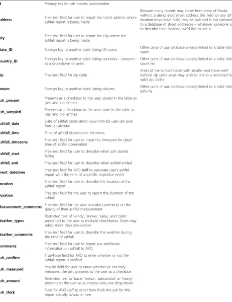
Id Primary key for ash reports; autonumber
Address Free-text field for user to report the street address whereashfall report is being made
Because many reports may come from areas of Alaska without a designated street address, this field (or any other location-descriptive field) may be null and is not constrained to a database of street addresses–whatever someone uses to describe their location, we’d like to see it.
City Free-text field for user to report the city where the ashfall report is being made
State_ID Foreign key to another table listing US states Other parts of our database already linked to a table listing states
Country_ID Foreign key to another table listing countries–presents as a drop-down to users
Other parts of our database already linked to a table listing countries
Zip Free-text field for zip code
Areas of the United States with smaller and more well-defined zip code areas may wish to link to a restricted list of valid zip codes
Datum Foreign key to another table listing datums Other parts of our database already linked to a table listing datums
Ash_present Presents as a checkbox to the user; stored in the table as
‘yes’and‘no’entries
Ash_sampled Presents as a checkbox to the user; store in the table as
‘yes’and‘no’entries
Ashfall_date Date of ashfall observation: yyyy-mm-dd; user can pick from a calendar
Ashfall_time Time of ashfall observation: hh:mm:ss
Ashfall_timezone Free-text field for user to input the timezone for date/ time of ashfall observation
Ashfall_start Free-text field for user to describe when ash started falling
Ashfall_end Free-text field for user to describe when ashfall ended
Event_datetime Free-text field for AVO staff to associate user’s ashfall report with the time of a specific explosive event
Location Free-text field for user to describe the location of the ashfall report
Duration Free-text field for the user to report the duration of the ashfall
Measurement_comments Free-text field for the user to make comments on the quality of their ashfall measurement
Weather_types
Restricted text of‘windy’,‘snowy’,‘rainy’, and‘calm’ presented to the user as multiple checkboxes. Users may select more than one option
Weather_comments Free-text field for user to describe the weather during the time of ashfall
Comments Free-text field for user to report any additional information on ashfall to AVO
Ash_confirm True/False field for AVO to enter whether or not the ashfall report is verified
Ash_measured Yes/No field for user to enter whether or not they measured the ash; presents to the user as a checkbox
Ash_amount Restricted text to‘trace’,‘minor’,‘substantial’, or‘heavy’; presents to the user as as choose-only-one drop-down
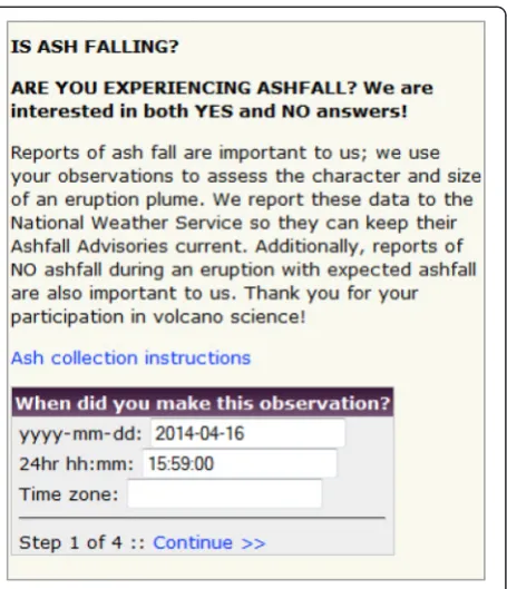
Web-form 1(Figure1):Timing of the observation. The date and time are automatically filled with the current date and time; if a user clicks within the window to edit it, a calendar pops up.
Web-form 2 (Figure 2): Location of the observation. Because many areas of Alaska are remote and not within a populated area or zip code, users have several options for reporting location. If a user clicks a location on the map and also enters a physical address, the map location is used. Location information is not required to submit a report.
Web-form 3(Figure3):Duration and amount of ash fallout. This form initially presents the instruction
“If ash was present, click this checkbox”. If users do not click the checkbox, they immediately advance to the final entry form. Reports of no ashfall are also valuable because they are used to update public hazard notifications and help calibrate model outputs. If the users do check the box, they are prompted for further details about the ashfall. If they check that they measured the ash, the window expands for ash thickness information. If they further check that they collected a sample, the window expands to the extent shown in this figure. Although we would like users to enter their start and stop times with precise military time, the form is a free-text field to encourage users to report the
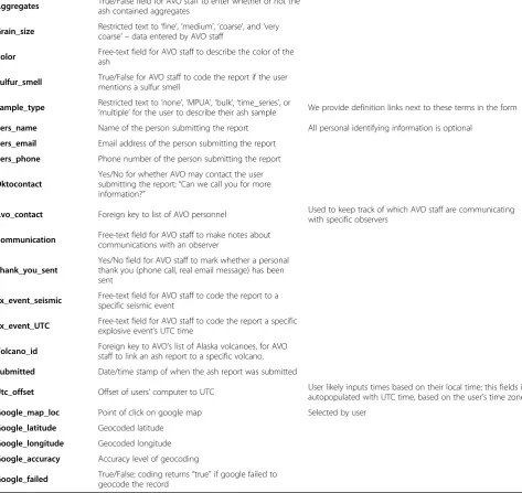
Table 1 The main database table and its essential fields(Continued)
Aggregates True/False field for AVO staff to enter whether or not the ash contained aggregates
Grain_size Restricted text to‘fine’,‘medium’,‘coarse’, and‘very coarse’ –data entered by AVO staff
Color Free-text field for AVO staff to describe the color of the ash
Sulfur_smell True/False for AVO staff to code the report if the user mentions a sulfur smell
Sample_type Restricted text to‘none’,‘MPUA’,‘bulk’,‘time_series’, or
‘multiple’for the user to describe their ash sample We provide definition links next to these terms in the form Pers_name Name of the person submitting the report All personal identifying information is optional
Pers_email Email address of the person submitting the report
Pers_phone Phone number of the person submitting the report
Oktocontact
Yes/No for whether AVO may contact the user submitting the report;“Can we call you for more information?”
Avo_contact Foreign key to list of AVO personnel Used to keep track of which AVO staff are communicatingwith specific observers
Communication Free-text field for AVO staff to make notes about communications with an observer
Thank_you_sent
Yes/No field for AVO staff to mark whether a personal thank you (phone call, real email message) has been sent
Ex_event_seismic Free-text field for AVO staff to code the report to a specific seismic event
Ex_event_UTC Free-text field for AVO staff to code the report a specific explosive event’s UTC time
Volcano_id Foreign key to AVO’s list of Alaska volcanoes, for AVO staff to link an ash report to a specific volcano.
Submitted Date/time stamp of when the ash report was submitted
Utc_offset Offset of users’computer to UTC User likely inputs times based on their local time; this fields is autopopulated with UTC time, based on the user’s time zone
Google_map_loc Point of click on google map Selected by user
Google_latitude Geocoded latitude
Google_longitude Geocoded longitude
Google_accuracy Accuracy level of geocoding
timing as best they can. The predefined choices for ashfall thickness are used in formal hazard
statements in the US and are easier for users to quantify and select.
Web-form 4(Figure4):Contact information. This form emphasizes that AVO will not distribute personally identifiable information (PII), and specifically states how AVO will use their information. The ash report is not submitted to AVO unless the submitter checks the“Send ash
report”button. After sending, AVO confirms the ash submission on screen, and sends an automated “thank you”email if the user provided an email address and permission for contact.
AVO provides ashfall collection instructions in many locations on the webpage, in a variety of formats, includ-ing printable instructions, a datasheet, illustrated web pages, and a video tutorial (Wallace and Kristi 2009).
During an eruption, reports submitted via the web form automatically generate a public ashfall report map (Figure 5) displayed on the activity page of the erupting
volcano on AVO’s webpage. The map shows the location
of both positive (+, yes ash) and negative (−, no ash) re-ports of ashfall over a 24-hour period. Symbols are color-shaded by time in order to discriminate multiple ashfall events. Reports that are not successfully geocoded are not included on the map display but still exist as re-ports and show up in the list and spreadsheet views which are available only to Observatory staff. The public map is updated every five minutes, without personally identifiable information and with reduced-precision lo-cations. The public map also bears a disclaimer that the map may contain erroneous reports. AVO attempts to cor-rect errors when we find them, time permitting. There are no minimum submission requirements, although incom-plete reports are of limited value and those without both location and notation (by checking boxes) whether ash is present or not, will not be displayed on the map. This map is the only automatic display of ashfall information avail-able to the public; other information known about ashfall is delivered as formal ashfall warning messages (refer to the following section on “how the ashfall reporting data-base is used in eruption response”). We chose to display
only information on the occurrence (+) or lack of (−)
Figure 1Web-entry screen 1 of 4 which requests information about the timing of the observation.
Figure 3Web-entry screen 3 of 4 which focuses on duration and amount of ashfall.
ashfall because it is the most reliable data collected from the public. Other data on ashfall (such as thickness), are often erroneous perhaps due to confusion between metric versus English units and often require follow-up calls to verify. Extended data on ashfall collected from the public (deposit thickness, ashfall duration, weather conditions during ashfall, and timing of ashfall) are verified by AVO before forwarding the information to agency partners who may use these data in formal warning products.
The bottom of each page of the ashfall reporting forms also bears our US Office of Management and Budget (OMB) control number, the expiration date, and the Paperwork Reduction (1980), a requirement by the US Federal government when collecting data from the pub-lic via a government website.
The Observatory’s experience
When a user clicks the “send ash report” button, the
data are entered into our database, location information is geocoded, AVO’s internal review map, .csv, and .html reports are updated, and a notification email and text message is sent to designated AVO staff members. There are no restrictions on the internal review map (Figure 5),
unlike the public map, and AVO staff can click on the
map icons (+ and–symbols) to obtain detailed
informa-tion about ashfall observainforma-tions, and can contact the obser-ver for clarification if permission is given by the obserobser-ver. An adjustable timeline (year, month, day) located at the bottom of the internal review map adjusts the view to dis-play observations from specific ashfall events or all obser-vations over a specified time frame.
more reliably with follow-up calls. Our review form also lets us keep a time-stamped running communications log about each ash report.
Discussion
How the ashfall reporting database is used in eruption response
With the ashfall database, AVO staff condenses and summarize the various ashfall reports and forward infor-mation on to other agencies, emergency managers, and the wider public. The online, automatic database frees staff resources during very busy eruptive periods,
espe-cially compared to AVO’s previous requests that
indi-viduals phone AVO with ashfall reports. Because most reports of ashfall come to AVO rather than other agen-cies, this new system provides a much more efficient means of digitally collecting, displaying, and distributing such information to other agencies and the public.
During ash-producing eruptions AVO works directly with NOAA’s National Weather Service (NWS), the agency responsible for issuing public ashfall warning messages and advisories about airborne ash clouds (in Alaska). These re-ports from the public also give scientists a more complete record of the location, amount, duration and other condi-tions of ashfall that are used to improve both NWS and AVO hazard advisory products.
Previously, AVO called the NWS for each ash report, which often was redundant and time consuming. AVO now shares a version of the database with the NWS so they have the same information at the same time as the Observatory. NWS staff can see which reports have been verified by AVO and which have not, and use this infor-mation to inform their warning messages, or they can call AVO for clarification as needed. Because AVO staff manually enter those ashfall reports that still sometimes do arrive via phone and email into the database, all in-formation known to AVO about ashfall is contained in the ash reporting database allowing for easy querying.
Reports of ashfall are also shared with other agencies responsible for various impacts from ashfall, including the Alaska Department of Environmental Conservation (AK-DEC) Division of Air Quality Program, the AK-DEC Division of Environmental Health Drinking Water Pro-gram, and the Alaska Department of Health and Social Services Public Health Division (AK-DHHS), which have a mandate to warn of possible impacts to air quality, drinking water quality and public health, respectively.
(For additional information on AVO’s information
dis-semination procedures, see Madden et al. 2014).
Scientific benefits of the ashfall reporting database First-hand accounts of ashfall support development of ash dispersion and deposition models, interpretation of satel-lite imagery, and guide field mapping. Public collection of
samples improves researchers’ ability to perform
time-incremental studies and make isomass maps of ashfall across broad geographic areas that would otherwise not be possible.
Ash fallout modelers make assumptions about erup-tion parameters, such as particle size distribuerup-tion, par-ticle density and mass of erupted material (Mastin et al. 2009). Ground-truth information about the timing, thick-ness and accumulation rate can be used to calibrate these models so that realistic model simulations can be pro-duced (Schwaiger et al. 2012).
Satellite imagery is most often used to track drifting ash clouds overhead and, occasionally, ash fallout on the ground. Discrepancies between the amount, location and timing of overhead ash clouds and subsequent ash fall-out on the ground may be explained with better ground-truth data on ashfall.
Physical samples and field measurements of typically ephemeral deposits used to calculate mass and volume of erupted material are important to more accurate es-timates of the size of an eruption. Many observers are in remote, off-road areas that are inaccessible to Ob-servatory staff during ashfall. Reports and samples of such deposits are unlikely to be known except by local observers.
AVO has now used the ashfall reporting database dur-ing several eruptive periods with ashfall: the latter stages of the Redoubt 2009 eruption, and the eruptions of both Pavlof and Veniaminof in 2013. Because Redoubt Volcano is located near Alaska’s most populous region and pro-duced 19 ash plumes during its 2009 eruption (Wallace et al. 2013), AVO received numerous (~250) ashfall re-ports. “Is Ash Falling?” was not formally approved for public use until July 1 2013, so all Redoubt ash reports were manually entered into the database by AVO staff. Reports submitted via the online web forms for more recent Pavlof and Veniaminof eruptions were less nu-merous (19) because these volcanoes are in remote lo-cations and populations are small, but if it were not for these observations, we would have no information about ashfall. Submission via the online form proved an efficient way to both learn about ashfall across the Observatory and to forward to other emergency managers. We also think that the web form helped to improve the quality of observations because the questions guide users through the report.
Naming the ashfall reporting database
Falling?”. It is the first of its kind to collect observations during an event rather than after an event has occurred. We hope that product branding from these very success-ful and well-known databases will facilitate the recogni-tion and use of our ashfall reporting database even in international settings.
Potential for portability of“Is Ash Falling?”
This database was designed for the Alaska Volcano Observatory where ashfall events are common and occur
on average 1–2 times per year. Users are permitted to
submit reports from locations outside of Alaska which is intended to capture ash fallout originating from Alaska volcanoes from widely dispersed ash clouds. The data-base is, however, open-source and can easily be exported and modified for use at other observatories or agencies that collect information on ashfall in the US and inter-nationally. This tool will soon be operational at other US volcano observatories. AVO is currently working with the Institute of Geological and Nuclear Sciences (GNS) in New Zealand to create an international version of
“Is Ash Falling?” for use in New Zealand. Contact the
authors for more information on obtaining the code for this database.
There is potential for designing a single“Is Ash Falling?” database that could be used to report ashfall anywhere on earth, similar to how the USGS “Did You Feel It?, Earth-quake reporting database (2005)”database currently works for reporting earthquakes. Considerations about data man-agement however, have prevented us from pursuing such a version at this time.
Lessons learned in development
Because of the more than 20 years experience request-ing the public’s assistance in making observations and collecting ashfall samples during eruptions, AVO had already developed successful paper-based data-collection forms. Questions from these forms were used as the framework for developing the on-line tool. AVO also already had a MySQL database underlying its public and operational web sites so the ash-reporting database was created as a module using the same programming language and table structure, and was integrated into the existing database.
Concerns about user-completion and data integrity led us to design our input forms to include suggested data formats such as yyyy-mm-dd, for time, or pull-down me-nus rather than free-text answers. From experience how-ever, we also include a number of free-text fields so that users do not feel so restricted that they avoid filling in the information. The initial webforms presented as several pages requesting many small bits of informa-tion, and felt overwhelming. In an effort to streamline the user experience, the current forms only expand to
request further information when initial answers (yes to ashfall, yes to measurements, yes to ash collection) war-rant asking these questions. We believe this will pro-vide both a better user experience and greater data integrity. For example, people who report negative ash-fall will not also be able to report an ash thickness.
We also realized that because AVO cannot instantly verify all reports, if we wanted to display + and –ashfall reports on the public website, we needed a disclaimer on the public map. We also developed faster ways for Observatory staff to delete erroneous reports from the database.
Because we collect user identity and location
infor-mation, we need to be sensitive and protect citizen’s
privacy. In consultation with the US Office of
Manage-ment and Budget (OMB – the US government agency
responsible for regulating permission to collect person-ally identifiable information-PII), we modified the map scale tool on the public map to restrict the location precision, protecting PII. Precise ashfall locations are not needed for formal NWS Ashfall Advisory state-ments, but are of great assistance to ashfall modelers and Observatory scientists. Potentially the most time-consuming part of developing“Is Ash Falling?” was ap-plying for and obtaining the permissions required by the US Federal government for collecting data from the public via a government website. This process took 1.5 years to complete and was a required step in making the database operational.
As both AVO and the public gain experience in using
“Is Ash Falling?”, we would like to survey Observatory staff and the public at some future point in time for their suggestions on improvements and modifications.
Conclusions
Abbreviations
API:Application Programing Interface; AVO: Alaska Volcano Observatory; AK-DEC: Alaska Department of Environmental Conservation; AK-DGGS: Alaska Division of Geological & Geophysical Surveys; AK-DHSS: Alaska Department of Health and Social Services; GNS: Geological and Nuclear Sciences; GeoDIVA: Geologic Database of Information on Volcanoes in Alaska; MODIS: Moderate-resolution Imaging Spectroradiometer; NWS: National Weather Service; OMB: US Office of Management and Budget; PHP: hypertext Preprocessor scripting language; PII: Personally Identifiable Information; US: United States of America; VAAC: Volcanic Ash Advisory Center.
Competing interests
The authors declare that they have no competing interests.
Authors’contributions
KW is a U.S. Geological Survey geologist with the Alaska Volcano Observatory whose research focus is volcanic ash. Her responsibilities during eruptions include mapping and collecting volcanic ash to characterize and calculate mass and volume of erupted products. She also coordinates ashfall information with emergency managers during ashfall events in Alaska. SS is the computer systems and database manager for the AVO website at the Alaska Division of Geological & Geophysical Surveys (AK-DGGS). CC designs and populates the Geologic Database of Information on Volcanoes in Alaska (GeoDIVA). All authors read and approved the final manuscript.
Authors’information
KW is a U.S. Geological Survey geologist with the Alaska Volcano Observatory whose research focus is volcanic ash. Her responsibilities during eruptions include mapping and collecting volcanic ash to characterize and calculate mass and volume of erupted products. She also coordinates ashfall information with emergency managers during ashfall events in Alaska. SS is the computer systems and database manager for the AVO website at the Alaska Division of Geological & Geophysical Surveys (AK-DGGS). CC designs and populates the Geologic Database of Information on Volcanoes in Alaska (GeoDIVA).
Acknowledgements
We would like to thank Angie Diefenbach for collating ash reports during the 2009 eruption of Redoubt volcano used as the basis in developing“Is Ash Falling?”.
Author details
1U.S. Geological Survey, Alaska Volcano Observatory, Anchorage, Alaska, USA. 2Alaska Division of Geological & Geophysical Surveys, Alaska Volcano
Observatory, Fairbanks, Alaska, USA.
Received: 29 May 2014 Accepted: 26 December 2014
References
Adleman JN, Cameron CE, Snedigar SF, Neal CA, Wallace KL (2010) Public outreach and communications of the Alaska Volcano Observatory during the 2005–2006 eruption of Augustine volcano. In: Power JA, Coombs ML, Freymueller JT (eds) The 2006 eruption of Augustine Volcano. Geological Survey Professional Paper 1769, Alaska: U.S, pp 631–644 [http://pubs.usgs. gov/pp/1769/chapters/p1769_chapter27.pdf]
Casadevall TJ (1994) Volcanic ash and aviation safety: proceedings of the first international symposium, Seattle, Washington, July 1991. In: U.S. Geological Survey Bulletin B 2047., p 450
Did you feel it?, Earthquake reporting database (2005) U.S. Geological Survey, Denver, CO. http://earthquake.usgs.gov/earthquakes/dyfi/. Accessed 19 September 2014.
Did you see it?, Landslide reporting database (2014) USGS Denver, CO. [http://landslides.usgs.gov/dysi/]. Accessed 19 September 2014. Madden J, Power J, VanPeursem KW, Holt G, Devaris A, Brennell J, Hartig L
(2014) Alaska interagency operating plan for volcanic ash episodes., p 51, http://www.avo.alaska.edu/pdfs/cit3996_2014.pdf
Mastin LG, Guffanti M, Ewert JE, Spiegel J (2009) Preliminary spreadsheet of eruption source parameters for volcanoes of the world: U.S. Geological Survey Open-File Report 2009–1133, v. 1.2., p 25 [http://pubs.usgs.gov/of/ 2009/1133/]
Paperwork Reduction Act (1980) Pub. L. No. 96–511, 94 Stat. 2812, codified at 44 U.S.C. § 3501-3521
Schwaiger HF, Denlinger RP, Mastin LG (2012) Ash3d, a finite-volume, conservative numerical model for ash transport and tephra deposition. Journal of Geophysical Research 117:B04204, doi:10.1029/2011JB008968
Wallace, Kristi L. (2009) Alaska Volcano Observatory Ash Collection Instructions. http://www.avo.alaska.edu/ashfall.php]. Accessed 22 September 2014 Wallace K, Schaefer J, Coombs M (2013) Character, mass, distribution, and
origin of tephra-fall deposits from the 2009 eruption of Redoubt Volcano, Alaska—highlighting the importance of particle aggregation. JVGR special issue: 2009 Redoubt Eruption 259:145–169 [http://dx.doi.org/10.1016/ j.jvolgeores.2012.09.015]
Submit your manuscript to a
journal and benefi t from:
7Convenient online submission 7Rigorous peer review
7Immediate publication on acceptance 7Open access: articles freely available online 7High visibility within the fi eld
7Retaining the copyright to your article