CORINTH, 1970: FORUM AREA
(PLATES 1-11)
?9
HE spring excavation of the American School of Classical Studies was con-
ducted during 1970 at Corinth in four areas. The School excavated around
the Sacred Spring and immediately west of Roman Temples H and J, at the west
end of the Roman forum.' Professor Henry S. Robinson, former director of the
American School, this year continued investigation of the north slope of Temple Hill
as part of the spring campaign of the School; Dr. Nancy Bookidis excavated within
the sanctuary of Demeter and Kore on the north slope of Acrocorinth.'
The work of the 1970 excavation season was designed to supplement the study
started in 1968 of the physical remains of the temenos of the Sacred Spring.3 More
of the configuration of the conglomerate cliff that formed the western side of the
valley of the Lechaion Road has now been revealed in the area around the Sacred
Spring. Excavation also exposed the east-west line of bedrock where it stretched
eastward across the southern end of the valley south of the Sacred Spring to become
one with the conglomerate ledge over Peirene. The shape of the original sanctuary
of the Sacred Spring appears to have been contained within the valley formed by these
cliffs.
The first evidence, however, for human occupation on the west side of the valley
in the area of the Sacred Spring is in the Early Helladic Period, if one excludes the
stratum of water-worn Neolithic pottery and gray earth over bedrock at the base of
the conglomerate and marl cliff, just south of the classical fountain house of the
Sacred Spring. The Early Helladic remains are two partially excavated walls, built
of large field stones held together by clay mortar. The wall that is more completely
exposed is over 0.65 m. wide. Both walls are constructed on the bedrock that forms
the western cliff of the valley, 1.50 m. south of the west end of the triglyph wall of
the Sacred Spring. The remains, as presently exposed, disappear into unexcavated
'Thanks are here expressed to Professor James R. McCredie, Director of the American School, for the aid and advice helpfully offered during the year, which contributed to the smooth operation of the excavation, and to Mrs. Evangelia Deilaki, Ephor of the Argolid and Corinthia. The student area supervisors were Misses Mary Berg, Margot Camp, Sharon Herbert, Frances van Keuren, Messrs. John Lavezzi and Robert Pounder. Miss Kathryn Butt deserves special thanks again this year for her direction of the work in the museum, as does Mr. Photios Notes for his work as general excavation foreman. Ioannidou and Bartzioti photographed the finds of the excavation and did much of the end of the season photography.
2 Separate reports are to be published by Professor Robinson and Dr. Bookidis on their
portions of the 1970 excavation. Mr. Joseph Shaw rendered invaluable service as architect for Professor Robinson's study of the archaic temple and as architect for the Demeter sanctuary.
3 C. K. Williams, II, Hesperia, XXXVIII, 1969, pp. 36-63; Hesperia, XXXIX, 1970, pp. 1-39.
Hesperia, XL, 1
American School of Classical Studies at Athens is collaborating with JSTOR to digitize, preserve, and extend access to Hesperia
2 CHARLES K. WILLIAMS, II AND JOAN E. FISHER
ILi
-j0
W Z.
~ ~ ~ ~ ~ ~ ~ ~
.60~~~~~~~0
e. \,,
~
~ ~
~
~
~
~
~
0 r I.. X.~~~~~~~~~~~~I
X.~~~~~~~~~~~~~~~~~~~~~~~~~~~~
~~~~~~~~~~~~
~~~~~~~~~~~~~~~~~~~~~~c(1) 44
__
~
~
~
Id~~5 w ir~
~
w~~~~~~~~'U
Id /1~~~~~~~~~~~~~~~~~~~~~~-
- \~~~~~~~~~~.\\ \\ 1~~~~~~~~~~~~~~~~~~~~t
~~~~~~~~~~~~~~~~~~~~~~~-
~~~~~~
~ ~ ~ ~ ~ ~ ~ ~ ~ ~
''~~~~~~~-_J //
~~
/;,* \-s
I/I~~~~~~~~CORINTH, 1970: FORUM AREA 3
earth toward the west. Immediately south of the walls, the level contains pottery
of the Early Helladic II period, uncontaminated by later disturbances. This stratum
appears to cover most of the bedrock above the cliff edge; in places, however, the
stratum has been partially cut into by later inhabitants of the area.
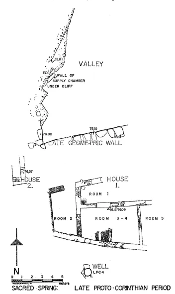
PROTOGEOMETRIC AND GEOMETRIC LEVELS
(Fig. 1)
The valley around the Sacred Spring preserves signs of occupation once again
in the Protogeometric period and from then continuously until the Roman destruction
of Corinth. A deep fill containing fragmentary Protogeometric pots (1-4; P1. 6) was
discovered 18 m. south of the triglyph wall. This appears to have been dumped over
the bedrock floor of the valley at the end of the Protogeometric period. Above this
fill were found fragmentary walls of the Geometric period; these were not thoroughly
investigated, however, for they were partially covered by a house of the Proto-
corinthian period. The south wall of the Protocorinthian house may, itself, have
been built in the Geometric period, perhaps originally as a terrace wall, since a fill
0.52 m. deep containing Geometric material was found packed along its south face.
A larger and more substantial wall of the Geometric period was also discovered;
its northernmost preserved stones are only 4.80 m. south of the triglyph wall of the
Sacred Spring. This is a heavy terrace wall of large, unshaped blocks of conglomerate
built on the top of the western cliff of the valley (Fig. 2, P1. 1, a, and b, no. 1). At
7.80 m. south of the triglyph wall, a right-angled leg stretches eastward into the valley
from the western cliff. The wall was built, apparently, to provide an area or terrace at
a high level immediately south of the Sacred Spring and, at the same time, to protect
the water source north of the terrace from being buried in the terracing operation.
PROTOCORINTHIAN
AND CORINTHIAN LEVELS
(Figs. 2, 3, 4, P1. 2)
At the beginning of the Protocorinthian period, the spring in the cliff side
immediately north of the Geometric terrace wall was improved as a water source. The
southern cavern or supply chamber of what was to become the classical fountain
house of the Sacred Spring appears to have been built at this time. The supply
chamber is a simple affair, built into the marl cliff face of the valley under the con-
glomerate overhang.4
The building project at this time required the laying of a stone floor, channeled
for the flow of water, and the sealing of the joints in the stone floor with bronze.
A cut poros wall was built on this floor in one place along the marl scarp rising to
CLt
91
VALLEY
CLIFVF ED WALL OF SUPPLY CHAMBER
- UNDER CLIFF
ATE OMETRIC
ROOM 2 ROM3 ROOM 4 ROOM 5
SACRED SPRIN: EAL POroUo STEA1
CORINTH, 1970: FORUM AREA
5
the conglomerate ledge; a second poros wall was built at a minimum of 0.60 m. out
from the first wall and also rose to the natural rock roof. Thus a chamber was
formed at cliffside that collected the ground water and drained it to the northeast,
where it was then gathered for use. Any discussion of the late 8th century form of
the fountain house is outside the limits of the present report. Once the water-
collection chamber was completed, however, an earth fill was thrown against the
outside face of the southeast wall of the chamber. This fill contained, exclusively,
Protocorinthian linear patterned kotylai, other body sherds with Protocorinthian
linear patterns, and coarse wares; no sherds were found with added purple decoration.5
An equivalent stratum with Protocorinthian pottery was found thrown against
the north face of the Geometric terrace wall south of the spring. This stratum may
be another part of the fill which was dumped against the south wall of the supply
chamber of the spring house. The pottery found against both walls appears to be
of the same date.
During the 1970 excavation season, one house and the easternmost room of at
least one other, immediately to its west, were found to have been built on the Geo-
metric terrace about 12.30 m. south of the triglyph wall. Their date of erection,
however, has yet to be determined. The east end of the eastern house was partially
destroyed by a later construction or alteration, a classical underground water channel
that cut into the Protocorinthian levels. Except for this limited area of disturbance,
'however, the Protocorinthian structure was well preserved. The building had gone
through three phases of occupation, clearly distinguished by levels of destruction, by
rebuilt and replastered walls, and by superimposed floor levels.
The original house (Fig. 2, P1. 2) is composed of at least five rooms: a courtyard,
room 1; two of unspecified use, rooms 2 and 3; and the two " half-cellars," rooms
4 and 5. The court at the north of rooms 3, 4, and 5 is 1.90 m. wide. Its length
from east to west is not measurable; only 0.35 m. of its north wall and nothing of its
east wall are preserved. That this is an exterior space or court, however, is attested
by its floor which is made of a layer of fine poros chips and powder, hard packed,
and probably laid when wet to form a cement-like surface. The door that connects
rooms 1 and 3 still preserves its well-cut poros threshold, fashioned from a single
block 1.28 m. long and 0.49 m. wide. Apparently, also, room 3 is one of the most
important rooms of the house. It is 2.90 m. wide and between 2.75 and 3.40 m.
long from north to south.
Rooms 4 and 5 were constructed as " half-cellars " with their floors over 0.55 m.
below the poros threshold of the door connecting rooms 1 and 3. Room 5 has been
largely cut away by the construction of a classical drain; room 4 is preserved almost
in its entirety. Only a little over a square meter of its southeast corner has been
destroyed by the construction of the drain.
-6 CHARLES K. WILLIAMS, II AND JOAN E. FISHER
I
'I
/ 'I
/~CLIF
VALLEY
EG
. ALL OF
SUPPLY CHAMBER UNDER CLIFF
* 600
E G OMTRIC WALL
!~
T657bOUSE
~<
H
OUSEta t ~ROOM1
ROOM 2 ROOM 3-4 ROOM 5
A~ WELL
N
. - LPC40 1 2. 3 4 5
SACRED
SPRNG:
LATE PROTO
-CORINTHIAN
PERIOD
CORINTH, 1970: FORUM AREA 7
The walls of room 4 stand to a height of between 0.40 and 0.65 m. without any
trace of doorway or stair leading into the space. Two things show that rooms 4 and
5 were originally built to serve as " half-cellars." First, the rooms are purposely dug
into the pre-existing fill in order that their floors can be between 0.45 and 0.50 m.
below the other floors of the house. This is clearly seen at the south side of room 4
where the house is built against a Geometric wall, mentioned above as possibly
having been constructed originally as a minor terrace wall over 17 m. south of the
triglyph wall. This Geometric wall is employed as the south wall of the Proto-
corinthian house. Since the bottom of the Geometric wall never went to the depth to
which the floor of the " half-cellar " was later dug, the Geometric wall was left
resting on 0.40 m. of earth above the floor of the " half-cellar." The other three
walls of the room were constructed, however, directly on the basement floor. Secondly,
the rooms were used as " half-cellars " when they were first built and not filled in
immediately because the " half-cellar " walls were found mud-plastered. All of this
indicates that the builders of the house excavated to build the two " half-cellars " to
serve purposes now unknown. No indications of the function of these spaces were
found during the excavation.
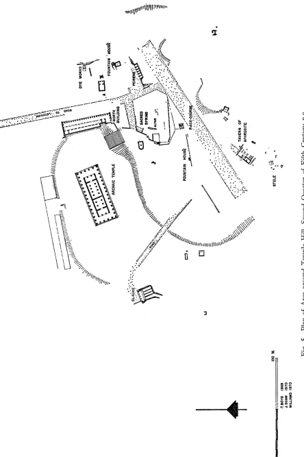
The house was altered with the filling in of the " half-cellar " rooms 4 and 5
and with the uniting of rooms 3 and 4 into one space (Fig. 3). This new area,
room 3-4, serves in this second period as an industrial courtyard, in which a furnace
or oven was built. The furnace is built completely of mud or pise, apparently on a
packing of fist-sized stones that was dumped into a depression in the floor of room
3-4. The fire chamber is an elongated oval, about 0.75 m. long and 0.28 m. wide,
preserved to a height of 0.18 m. The long axis runs north-south. The south end of
the oval chamber is against the south wall of the room. In the north end, slightly
below the floor of the oval chamber is a draft channel, approximately 0.10 m. square
in section, constructed within the mud. This channel goes north for about 0.20 m.
and then makes a right angle to the east. It was probably used to force air into the
fire chamber. When discovered, the fire chamber was completely filled with ash,
small hunks of limestone, and traces of iron oxide.
The court of the original house, room 1, may have continued in use as an open
space after the remodeling of the house, for a hearth was constructed in the south-
west corner of room 1. This appears to have been used intensively throughout the
second phase of the house, to judge from between 0.10 and 0.15 m. of accumulated
ash found there. Whether the hearth was used for domestic purposes or in con-
junction with the industrial enterprises of room 3-4 is uncertain. Much iron slag
was found on the floor of both room 3-4 and room 1.6
/ .4
I
F/{CLlFF/
VALLEY
EDGE ALL OF t
UPPLY'CHAMBER UNDER CLIFF
* .. *
RR A
I
t
UNDUG\
ROOM 2 ROOM 3 -4
&~~~~~~~~~~
0
WORK YARD
U0 6ASIN
SASRNTH C
CORINTH, 1970: FORUM AREA 9
Room 2 was rebuilt; its floor was raised to a level between 0.24 and 0.30 m.
above the original floor of the house. Its walls are plastered with a white-green clay.
The second use of the Protocorinthian house can be dated quite precisely, for the
house or industrial complex, if that is what it was converted to in its second phase,
was burnt to the ground unexpectedly. The floor of room 3-4 was found covered
with a more than generous amount of pottery and some lamps. The pottery (10-18;
P1. 7) is Late Protocorinthian in style; the lamps (19; Pls. 7, 9) have been dated
to the early 6th century
B.C.,but the shape apparently starts earlier.
At the time when the Protocorinthian house was burnt and destroyed, a well
(L P-C 4) of the same date, about 2.50 m. south of the house, also went out of use
and was filled. The well is circular in plan, with its shaft built of large stones slightly
shaped to give the inside a more perfectly circular form. The well descends for 3.25 m.
from the Protocorinthian ground level at the south side of the house (elev. 76.72).
The bottom 0.55 m. of the shaft was dug into the clay that underlies the conglomerate
of this area.
The bottom half meter of the shaft was filled with pottery dumped into the well
when the well was abandoned (20-31; Pls. 7, 8). All of the pottery recovered is frag-
mentary; even the coarse water jars do not mend into complete pots. Apparently
the well had been cleared of accumulated debris not long before it was finally
abandoned. No pure use fill was retrieved from the shaft.
The final alteration of the Protocorinthian house is the least well preserved of
the three phases of construction distinguished (Fig. 4). Room 3-4 is shortened
at its east side by about 1.50 m.; the space is still used, however, as an industrial
establishment. A simple hearth serves in this period, placed in the east side of the
area and constructed with unshaped stones in the form of a U. Room 2 is rebuilt;
its floor is raised between 0.03 and 0.09 m. above the second floor of the house. The
south wall of the room, which in phase 2 had been plastered with a white-green clay,
is dismantled and rebuilt further to the south. A door with a wooden threshold is
built into the wall at the southwest corner of the room, for the first time allowing
access to the south. Immediately south of the door, a 1.80 m. square of floor associated
with the third phase was excavated; in this area were found a circular shallow ash pit,
a clay-lined basin built into the earth floor, perhaps for washing clay, and a post hole
packed around with white clay, all apparently remains from the industrial activities
that were conducted south of the house.
No pottery, lamps, or tools were found on the floor of this building. Apparently
when the structure was abandoned, the furnishings, pottery, and goods were removed
by the occupants. The complete lack of artifacts suggests that the house was con-
10 CHARLES K. WILLIAMS, II AND JOAN E. FISHER
demned, expropriated, or bought to make room for the expansion of the temenos of
the Sacred Spring in the second half of the sixth century B.C.
THE SACRED SPRING
PHASE 1
The temenos of the Sacred Spring appears to have grown naturally around the
water source in the west cliff of the valley of the Lechaion Road. The spring was
given its first monumental construction in the last quarter of the 8th century (above,
pp. 3, 5). Pottery retrieved from the earth packed against the outside face of the
south wall of the supply chamber that leads to the spring house contained Early
Protocorinthian sherds.7 This ceramic evidence does not necessarily demand that
the spring house itself, in its peaked roof form, be Protocorinthian in date.8 Thus far
very little excavation has been carried out in the levels associated with the original
spring house, and as yet no pottery has been found that can be associated directly
with construction of the reservoir and the facade of the building.
PHASE 2
Excavation in 1968 indicated that the spring house lost its pediment at the
close of phase 1.9 This year, excavation and study suggest that the peaked roof of
the spring house is replaced in phase 2 with a flat roof. The top of the flat roof is
1.50 m. lower than the top of the cliff into which the spring house was built. A
stairway of seven steps was therefore constructed to connect the flat roof with the
top of the cliff (P1. 5, c). The east facade of the spring house may have been closed or
redesigned at this time; water would no longer have been taken from the original draw
basin at the east facade. This interpretation can be drawn from the scarp of undug
earth that still overlaps the southeast corner of the facade. It is now suggested that
during phase 2 the fountain has a flat roof with parapet wall on its east and north,
perhaps also on the south. Along the south side, however, a step may have been
used rather than a parapet wall, since at the south the early fifth century stratum
appears to have come to 0.24 m. below the top of the flat roof. It is now suspected
that a well head was placed on this roof, directly over the reservoir of the earlier
fountain house. From it, one would have drawn water from the reservoir below
while standing on the roof platform. The steps from roof to upper terrace would
have allowed persons to carry the water drawn from the reservoir directly to the
apsidal building on the upper terrace.
7 The excavators of 1903 exposed the south wall of the spring house; Corinth, I, vi, p. 161.
The pottery was not kept according to strata and is now unavailable.
8Hesperia, XXXVIII, 1969, pp. 38-40, phase 1.
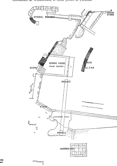
VA
\/ZZ
?
DYE. WORKS IZ
FOUNTAIN 'lOUS ARCHAIC TEMPLE NOR
GLAUKE-"" PE~~~~~~~~~~~~~~~~~~~~~~IRENE-
R EP
E
V
~
:~ ~
~
~
\\\\<~
~
~
~ ~
SCE \\ -. _lALTAR ' .
*.J
v v \ FOUNTAIN
HOUSe
RACE-COURSIE.-
,. i g TAVERN OF
APHRODITE
o lOO M. STELE '
.T.BOYD 1969 J.SHAW 1970 WILLIAMS 1970
12 CHARLES K. WILLIAMS, II AND JOAN E. FISHER
I
ST E AgL T A R~~~~~~~SON
yI
I i
'STE~~~~~~~~ L jl ',K
NORTH QUADRIGA f
SACRED SPRING
PHAtSE 3, WITH ALTERATIOH; Z~STEP Cl::L
o 5 meterT'.tS
CORINTH, 1970: FORUM AREA
13
At the time of the construction of the flat-roofed spring house, the area to the
east of it appears to have served as a vast, although not elaborate, theatral area.
This was paved with a hard-packed cobbled floor, sloping gently down from the south
to the area immediately east of the spring house; its southern limit is defined by
three steps of poros. These steps were found to extend to the east to within 13.00 m.
of the north-south roadway which passes along the east side of the sanctuary. The
line of steps extends westward along the south side of the temenos and terminates
after an apparently unbroken run (the complete length of steps has not been cleared)
of 21.40 m. At the west end of this line, a single line of poros blocks angles to the
northwest for at least 8.20 m. (see Fig. 6 where top of this poros line shows in floor
of phase 3). This northwest extension appears to have stopped about 12.60 m. south
of the spring house.
In the floor north of the steps is at least one line of cobblestones laid in an east-
west direction, parallel to the steps and to the contour lines of the floor (P1. 3, a).
The line appears to have been put into the floor to define a seating area on the sloping
floor or to define an east-west track along which activities were to take place or to
limit the area within which activities were to be held.
PHASE
3 (Figs. 5, 6)
14
CHARLES K. WILLIAMS, II AND JOAN E. FISHER
ably at the beginning of phase 3 a new, more elegant, north-south wall was erected to
mask the east face of the rough north-south leg of the Geometric terrace wall. A
single slab of the socle of this facing wall is now preserved, today abutting the foun-
dations of the south triglyph wall of the Sacred Spring. The line of the facing wall
was easily distinguished this year with the removal of a soft earth re-fill from what
had originally been the foundation trench dug for this wall. A great quantity of black
glazed pottery was recovered from this fill (39-49, P1. 9; also, Corinth pottery lot
no. 6457).
The pottery from this trench supplies a date for the abandonment of the north-
south line of the Geometric terrace wall and its later facing. Most of the north-
south segment of the Geometric terrace wall, its later facing wall, and the north-
south line of steps of phase 3 all were dismantled in the second quarter of the fourth
century, probably at the time when the last mud altar went out of use.
The floor that is laid to the north of the steps of phase 3 is studded with lines
of cobblestones, as was the floor of phase 2. These lines are between 1.20 and 1.30 m.
apart, laid parallel to the east-west line established by the poros steps of phase 3
(Fig. 6).
Evidence exists for at least three alterations during phase 3, exclusive of the
three reconstructions of the mud altar. The rebuilding of the drain that runs under
the poros paving slabs of the east facade of the early spring house was the first
alteration. This underground channel was built to conduct water from under the
conglomerate cliff south of the limit of the Sacred Spring to its place of use north-
east of the temenos, somewhere lower in the valley of the Lechaion Road. Originally,
the drain had been laid to conduct the water through the temenos; the water, how-
ever, was not to have been used therein. The alteration of this drain in phase 3
appears to have been extensive. All traces of the original drain, constructed at the
same time as the spring house faqade, were removed; a new trench was dug from
the southeast corner of the spring house southward to the rock ledge; an under-
ground corridor with water conduit was constructed therein (Fig. 6, P1. 3, b).
During this operation, a six meter long segment of the poros steps of phase 3 was
removed and replaced with a cobbled floor once the alteration was completed. A
certain amount of re-used material was incorporated into the walls and ceiling of the
new corridor, including drain blocks and a shallow stone basin.
The underground corridor (P1. 3, b) resembles the corridor that leads from
the triglyph wall at the northwest corner of the sanctuary of the Sacred Spring to a
point under the apsidal temple; each has a stuccoed water channel built against its
side wall.1"
The corridor that extends southward from the spring house is constructed of
good chisel-dressed poros blocks in ashlar style. It is 1.41 m. high at the south,
10
CORINTH, 1970: FORUM AREA
15
1.00 m. wide, with a water channel built as part of its east wall. The channel pro-
trudes 0.37 m. from the wall and thus contracts the free corridor space at floor level
to a width of about 0.63 m. The water channel itself is only 0.11 m. wide and about
0.09 m. deep. Only the channel and the corridor wall above it are covered with a
hard waterproof plaster. The floor of the corridor is the natural green-white marl
that underlies the conglomerate bedrock in this area.
The channel was built within the corridor so that it could be checked and cleaned
without the channel having to be re-excavated. Manholes (Fig. 6) were provided in
order that the tunnel could be serviced easily. One lies immediately south of the east
fa?ade of the spring house. The second (P1. 3, c) lies 15.10 m. farther south, almost
6 m. south of the top poros step of period 3 and northwest of the quadriga base, that
is, outside of the limits of the temenos.
More than 12 deep, rectangular holes were found randomly positioned in the
hard-packed poros chip floor that stretches southward from the poros steps and west
of the quadriga base (P1. 4, c). The holes had been dug during both phase 2 and the
early part of phase 3, apparently for the erection of wood stelai, votives, or statues
with rectangular bases. It is surprising, however, that these stelai or wood votives
were all dismantled at the same time, when the gravel fill was brought in for the
construction of the curb along the south side of the temenos just before the end of
phase 3. The two best preserved holes (P1. 4, a, b) were found with impressions of
the wood on their smooth side walls; the impressions were intact from floor level
to a depth of about 0.50 m. The two wood bases had originally been 0.09 and
0.13 m. thick, 0.23 and 0.24 m. wide. No organic matter or wood was found in the
holes; plaster casts made of the holes show, however, the impressions of wood grain
and tool marks that were left on the side walls of the rectangular holes. The side
walls of other holes were badly destroyed; this may be the result of the careless
removal of the stelai or votives in antiquity. The four best preserved holes suggest,
however, that not all the wood was removed when the new gravel fill and covering
floor were laid in the last part of phase 3; some bases may have been cut off at ground
level, which resulted in the preservation of the clear impression of their lower parts
in the earlier fill.
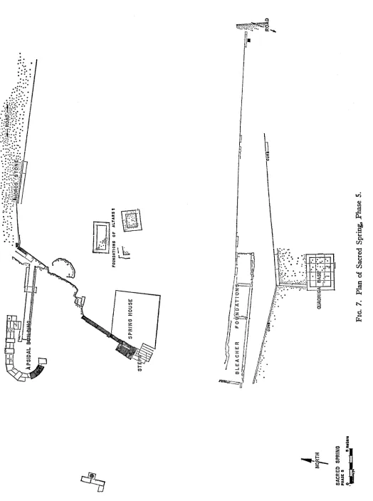
Just before the end of phase 3 and the abandonment of the long, low, mud altar,
the sanctuary undergoes a general alteration. The poros steps that had been used
in the first part of phase 3 are now removed, along with the stelai, and a gravelly
fill is laid down, or as at the southwest the steps are simply covered by the gravel
(Fig. 8). This gravel appears to have spread over the sanctuary generally, for it is
found as far north as the mud altar and, indeed, is the stratum on which the third
and fourth altars are built."
11 Hesperia, XXXVIII, 1969, phlase 3, pp. 43-46; XXXIX, 1970, pp. 23-24, pl. 11. Here
16
CHARLES K. WILLIAMS, II AND JOAN E. FISHER
The southern line of the temenos is rebuilt at the time when the gravelly fill is
laid down. A narrow curb is built to the south of the section of steps that in phase 2
angled to the northwest at the southwest corner of the sanctuary; the line of the
new curb approximates the orientation of this section of steps. Further east, how-
ever, the curb is built of wider poros blocks and laid immediately over the top step
of the stairway that had previously been used in phase 2; the wider curb thus follows
the line of the early steps.
Both the thinner and the wider curbs appear to have been built solely to delineate
the southern limit of the sanctuary of the Sacred Spring. The floor south of the
sanctuary ends flush with the curb; north of the curb, within the temenos, the floor
originally came up to within 0.15-0.27 m. of the top of the curb. This slight change
in level is the only definition that the south edge of the temenos appears to have
at the end of phase 3.
PHIASES 4,
5,
AND6 (Figs. 7, 9)
At least tlhree lines of bleachers or low grandstands, each representing a different
period of use, were constructed inside of the temenos as defined by the curb erected
at the end of phase 3. Bleachers ran along the whole south side of the sanctuary
during phases 4, 5, 6, and 7. They apparently were low timber structures on rubble
and poros block foundations (Figs. 7, 9, P1. 6). A fourth foundation with a slightly
different orientation, crossing the other three lines of foundation, also was dis-
tinguished. The difficulty of sorting these remains into their separate periods is
aggravated by the fact that the later bleacher foundations are laid out to overlap the
earlier foundation trenches and thus are dug into the earlier foundation trenches.
The wlhole south side of the temenos was not cleared this year; only the western-
most 22 m. of bleacher foundations were excavated. In the best preserved section,
rubble foundations were built over the earlier footings; it is possible to distinguish
three separate bleacher systems between phases 4, 5, 6, and 7 of the Sacred Spring
in those places where dainage from overlapping remains is minimal.
GENERAL CONCLUSIONS
Excavation has not yet penetrated to the lowest levels of the Sacred Spring
to any great extent. Thus form and function of the first phase of the temenos are
still relatively ill-defined. The limits of the temenos in its early period were probably
determined, however, by the shape of the valley and the natural cliff edge around
the spring. A spring house with peaked roof and east facade of columns or piers
was built against the western cliff of the valley of the Lechaion Road. By phase 2 of
*~~~~~~~~~~~~~~~~~~~ 4
HOROS ~~STON~"ROA.
FOUNDATION$ OF ALTARS I
ST X
.!~~~~~~~
UNtTH DRIAAS,
SACRED SPRING
PHASE 5
___ = =
-phcise3
UNEXCAVATED UNEXCAVTED
0_t I N-S SECTiON, LOOKiNG EAST
= -3voLtew ~~~~PHASE 3,1JNTERMEDICE- MUD
ALTAR-
~~~~~~~~~PHASES 2 AND -
SACRED SPRING
SCHEMATIC N-S SECTION, LOOKING E.
CORINTH, 1970: FORUM AREA
19the temenos, seats in the form of three poros steps were built along the bedrock
cliff edge south and west of the spring house. The floor sloped downward from these
seats toward the north and to the center of the sanctuary. The spring house was
altered and given a flat roof, which perhaps served also as a platform. A stairway
was built to connect the roof with the upper terrace immediately west of the spring
house. The ground level to the east of the spring house was raised with the beginning
of phase 3. At this time the poros steps along the south limit of the temenos were
rebuilt slightly to the north of the earlier steps. The earlier steps were covered and
abandoned, except that the top of the early step was still used to delineate the
southern limit of the sanctuary. During phase 3, a low altar over 8.75 m. long was
constructed of mud at the west side of the open area immediately east of the spring
house, then rebuilt three times. The altar was slightly curved, with its long axis
extending approximately north-south. East of the altar the temenos floor remained
unencumbered by buildings. The steps and altar were closely related one to the other;
the main purpose of the steps, however, does not seem to have been to serve viewers
of the sacrifice at the altar."2
Phase 4 saw the altar abandoned and covered, along with the later poros steps.
The temenos floor of phase 4 has now become relatively level, the result of repeated
fillings and the removal of the old Geometric wall that formed the western limit of
the theatral area. Thus, for the first time, the design of poros steps with ground
12 In cases where steps are designed to serve the devout during sacrifice, the steps are built
close to the altar and are designed so that the devout have a close-range view of the top of the altar and the priest as he sacrifices:
Amphiaraion. Vasileios Chr. Petrakos, 'O '.QporfO Kac To 'Iepov Tov) 'A,ufLapa'ov, pp. 96-99, fig. 19,
pls. A, 17. Altar oriented to the northwest with curved stairs centered on it.
Argos, Pythian Apollo. G. Roux, L'architecture de l'Argolide aux IVe et Ilre s. avant J-C., pp. 74-80, fig. 9. A passage of 1.48 m. separates altar from stairs. Stairs are laid out parallel to the altar.
Perachora, Hera Akraia. H. Plommer and F. Salviat, "The Altar of Hera Akraia at Pera- chora," B.S.A., LXI, 1966, pp. 207-215; plan, fig. 3. Altar and stairs within 1 m. of north end of altar, ca. 400 B.C.
The relationship of stairs to altar in the temenos of the Sacred Spring is not the samne as in the above examples; the focus of the steps is rather on the space east of the altar, where the devout probably stood during sacrifices. Numerous uses can be suggested for this open area, possibly an area for dramatic presentations, an assembly place, or a law court.
Thorikos. H. F. Mussche, J. Bingen, J. Servais, J. de Geyter, T. Hackens, P. Spitaels, A. Gautier, Thorikos 1965, III, p. 95, p1. 5. Theater with altar at one side of orchestra, seating capacity larger than that of the teimenos of the Sacred Spring.
Morgantina: E. Sjoqvist, " Excavation at Serra Orlando (Morgantina)," A.J.A., LXII, 1958, p. 161, figs. 30, 33, 36. This angled stepped area was probably used for outdoor meetings.
Athens. A. L. Boegehold, " Philokleon's Court," Hesperia, XXXVI, 1967, pp. 111-120. A possible assembly place or law court, 5th century steps on west side of the agora.
20
CHARLES K. WILLIAMS, II AND JOAN E. FISHER
sloping down to the north was abandoned and, instead, a long line of bleachers was
constructed to face a flat temenos floor at the north. This solution was used through-
out phases 4, 5, 6, and 7. Finally, with the end of phase 7 a race track that originally
ran well to the south of the temenos of the Sacred Spring (Fig. 9) was abandoned.
A new Hellenistic racetrack was built close to the south side of the triglyph wall of the
Sacred Spring; it buried almost completely the southern third of the temenos.
After the time when the race course was moved to its new position close to the
triglyph wall of the Sacred Spring, little can be told about the layout of the theatral
area of the Sacred Spring. The Roman foundation of the Captives' Fa?ade has
destroyed a large part of the area within the temenos and early excavation has
removed any chance of establishing the stratigraphy of the later Hellenistic period
here.
The identifiable coins recovered from the excavation of 1968-1970 help to
establish the absolute chronology of the eight phases of the temenos. In some cases,
however, the numismatic evidence suggests dates rather lower than those suggested
by the ceramic evidence. This is especially true for the fills accumulated during phase
3 and the fill covering the floor of phase 7. The differences in dates for both of these
levels can perhaps be explained partially by the fact that the ceramic finds were re-
trieved from earth which had been brought in from elsewhere. Pottery in these fills
thus might not have been in use at the very moment when the earth was dug up to
be spread over the temenos floor.
The earliest stratified coins, found in levels of the second half of the fifth
century, are two Corinthian silver fractions, nos. 1 and 2. These were recovered
during the removal of a floor that covered the original floor of phase 2, immediately
east of the porch of the spring house. Although coin no. 1 is earlier than the mid-
fifth century, it can be considered appropriate to this level. Apparently, it had been
used as a bijou or talisman, for it is pierced in order to be strung; it may have been
treasured for some time.
Five legible coins (5, 17, 123, 133, and 141), datable at latest to the first quarter
of the fourth century and accompanied by at least two illegible Corinthian Pegasos-
tridents, were recovered from floors that accumulated in the course of phase 3.
No. 17 is from this phase but is not from an area that is sealed by a later floor.
Coins 5 and 133 were found together at the east end of the temenos, above an early
floor of phase 3, on a floor similar in level, quality, and covering fill to the floor on
which a pottery deposit was found in 1969.'3 The pottery was found in a concen-
trated pile, inmmediately
southeast of the mud altars. The pottery is almost com-
pletely of Corinthian manufacture, dated to the very end of the fifth century. Caution
should be used, however, in coupling the pottery with the two coins because over
-LORf+fS ClY
m [ c r \ ~~~~~~~~~~~~~~~~~~~~~,
--- YEojsk
ARCHAIC NAISK0
TEMPLE NORTHX J
~GLAUKE'-
~~
Gil SACRED~~~~~~PE RAK
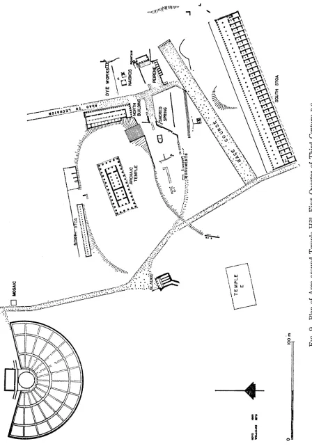
SPRIG ENFIG.~~~~~~~~~~~~~~~~~~V 9.Pa fAe rudTepeHlsFrtQate fTidCnuyBC
\T EMPLE
E
SOUTH STOA
22
CHARLES K. WILLIAMS, II AND JOAN E. FISHER
8 meters of undug fill separate the find spot of the coins from that of the pottery.
Pots 39-49 should be associated with the latest coins of this group.
Coins 11 and 154 were lost during the covering of the last floor of phase 3.
Coins 30, 74, 82, 86, 103, 108, 111, 118, 153, 155, 161, and 171 were recovered
from the fill dumped at the time of the abandonment of phase 4. Two coins, 79 and
107, were found in a pit dug into the floor of phase 5. Coins from the fill that covers
the final floor of phase 5 are 10, 71, 76, 85, 95, 100, 106, 109, 113-115, 131, 132,
148, 156-158, and 172. Coins 19, 78, 93, and 126 were recovered from the fill over
the floor of phase 6. A bronze of the Achaean League, coin 139, was recovered from
the earth into which foundations were laid for one of the later bleachers. This
find spot suggests that this coin had been in circulation before phase 7 and possibly
before phase 6, sometime after 280
B.C.A soft gray sand was found in a pocket along the north side of the stone
foundation of the bleacher of phase 7. This sand appears to have accumulated in
the course of phase 7. A number of whole pots were found therein, as well as five
identifiable bronze coins: three Corinthian Pegasos-tridents, 48, 59, and 65, one
Syracusan bronze, 127, and one Sikyonian bronze, 147.1'
The floors immediately above the gravelly fill that covered the mud altars and
that brought phase 3 to an end were all thin streaks of accumulated wash, gravel,
and poros chips. Each floor appears to have served for a short period of time. It
might thus be assumed that the time span from the beginning of phase 4 through
the end of phase 7 was not long.
The fill above the floor of phase 7 was deep reddish earth, containing almost
exclusively archaic and Neolithic pottery. This was not a natural accumulation; it
was brought in from outside of the area to raise the hollow so that the later race
course could be laid out here. The latest coin found in this fill is later than any of
the pottery;
15coin 128 is a bronze Alexander the Great, 336-323
B.C.;the other coins
are Corinthian Pegasos-tridents, 9, 63, 72, 73, 75, 88, 96, 98, 101, 102, and Sikyonian
bronzes, 146 and 152. The new race course must have been built in the third century,
however, for its fill covered such coins as 139.
The race course goes out of use with the destruction of Corinth in 146
B.C.Any coins from fills above the race course, even if Greek in date, were deposited
here in Roman filling operations or with some other Roman activity. Of special
interest in the post race course levels are a group of four silver coins, 136, 140, 174,
and 182, all recovered within a square meter of fill immediately under the poros
and cement bedding for the marble paving of the Roman forum. A Roman denarius
of 86
B.C.,181, was found during the removal of an early Roman wall that was built
immediately south of the area later occupied by the Captives' Faqade.16
14 Hesperia, XXXIX, 1970, pp. 4-5, nos. 2-6, for the pottery from this sand.
CORINTH, 1970: FORUM AREA
23
The coins found in the fill over the quadriga base, a soft earth apparently
deposited immediately after removal of the quadriga, were 94 and 165.17
New information has also been obtained for the better understanding of the
urban organization and land use at the head of the valley of the Lechaion Road."8
Excavation has exposed enough early remains below the level of the Roman forum
to suggest that the whole western half of the forum, from the Sacred Spring and the
Roman bema westward, was covered by domestic and industrial structures in the
Protocorinthian and Corinthian periods. This certainly is true of the area immediately
south of the Sacred Spring in the eighth, seventh, and earlier sixth centuries
B.C.(Fig. 1). Even in the Late Geometric period, land apparently was sufficiently in
demand for a large terrace wall (above, p. 3) to be built against the rock cliff
south of the spring in order that some of the uneven terrain could be reclaimed
along the west side of the valley. The Protocorinthian house (above, pp. 5, 7, 9)
which was built on this terrace is not the only structure to preserve evidence of early
industry in the valley. At least by the Middle Corinthian period, perhaps earlier,
a dye works had been established northeast of the Sacred Spring, in the area now
occupied by the Roman Peribolos of Apollo."9 Traces of domestic habitation are
present in this lower area, albeit recovered from sondages.20
Near the head of the valley, around the Tavern of Aphrodite and east of it,
about 70 m. south of the Sacred Spring, constructions built for domestic and semi-
domestic religious use began to displace Protogeometric, Geometric, and Early Corin-
thian graves. This displacement began as early as the Protocorinthian period.2"
Remains at the west end of the forum uncovered in the past two years have sug-
gested the same pattern, except that the domestic structures themselves have been
cut away by the Romans, leaving only graves, wells, and cisterns to testify to the
use of the land in the Early Iron Age. These remains suggest, however, that domestic
occupation started here in the Late Geometric period (wells 1, 2, and possibly
3),2217 Hesperia, XXXIX, 1970, pp. 6-9, nos. 7-9, for pottery found in this soft earth.
18 Ibid., pp. 32-39 for an earlier discussion of this valley.
"I C. K. Williams, II, Ackr., XXIII, 1968, XpovtKa, pp. 134-135. Note, also, mention of iron and bronze scoria from a foundry, dumped into a well of the 6th C. B.C. southwest of the Proto-
corinthian house, Charles H. Morgan, " Investigations at Corinth, 1953-A Tavern of Aphrodite," Hesperia, XXII, 1953, p. 135.
20 H. S. Robinson, S. S. Weinberg, " Excavations at Corinth, 1959," Hesperia, XXIX, 1960,
p. 246; C. K. Williams, II, AEXT., XXII, 1967, XpovuKa, pt. 1, p. 184; mention should also be made of a series of walls that date from the Geometric to the Corinthian period, found at the northeast corner of Temple A during excavation in 1965. These walls appear to have served for terracing. Fallen mud brick and domestic pottery were found in the levels associated with the Protocorinthian walls.
21 Charles H. Morgan, II, " Excavations at Corinth, 1936-37," A.J.A., XLI, 1937, pp. 543-
549, pl. XIII, 2; " Excavations at Corinth, 1953-A Tavern of Aphrodite," Hesperia, XXII, 1953, pp. 131-137, pls. 45-46.
22 Wells 1 and 3 are within the limits of the foundations of Temple F. The northern well
24 CHARLES K. WILLIAMS, II AND JOAN E. FISHER
with domestic changes in the Middle Corinthian period (well
4),23in the first half of
the fifth century (well
5),24in the fourth century (wells 6,
7),25and finally terminated
with the destruction
of Corinth in 146
B.C.(well 8 ?, cistern 1)
.26The area at the west end of the forum has not been completely dug; more wells
may be found with further excavation. Domestic construction, however, does appear
here to be replacing the burial ground of the Sub-Mycenaean, Protogeometric, and
Geometric periods from Late Geometric times onward.
PROTOGEOMETRIC AND GEOMETRIC POTTERY
The Protogeometric pottery recovered from the area of the Sacred Spring was
found in a trench dug against the south side of the south wall of the Protocorinthian
house (P1. 2, a, b). Here the stratigraphy was found to be composed of a 0.52 m.
deep fill of the Geometric period piled between the south wall of the house and the
cliff of bedrock farther south; beneath this fill was a thin floor of earth and burning
with large patches of charcoal. The earth beneath contained Protogeometric pottery
and a few Mycenaean sherds. This lowest stratum appears to have been a dumped
fill, descending from the thin floor without interruption to the bedrock that here
forms the bottom of the valley. The fill also goes under the floor of the Protocorin-
thian house and stretches northward toward the Geometric terrace wall. No archi-
tecture has yet been distingtuished that is to be associated with the Protogeometric fill.
Most of the pottery is coarse. The painted wares are fragmentary; the pieces
were scattered throughout the fill. A number of conical bases were recovered,
although not here catalogued. The decorated pottery appears to be largely of the
Late Protogeometric period.27
1. Protogeometric krater. P1. 6. C-70-177. Estimated D. of rim 0.240 m. Fragment of rim, upper body.
Slightly incurving wall of upper body; out- ward thickened rim, flat on top.
Four horizontal lines at max. diam. of body; upper body divided into vertically elongated panels by groups of 6 vertical lines; decoration in panels alternates between 2 crosshatched lozenges, one above the second, and plain immediately west of the Babbius Monument; it was excavated in 1968. Hesperia, XXXIX, 1970, fig. 4 for the position of these wells.
23 Well 4 was found 9 m. west of Temple J in 1970.
24 Well 5 was found west of Temple J, 2 m. east of well 4. It produced a large amount of
pottery, the bulk of which awaits detailed study.
25 Wells 6 and 7 were cleared in 1934 and 1935. They lie at the foot of the stairs that rise
westward to the temenos of Temple E. Well 7 contained 6 coarse ware pitchers, C-35-637 through C-35-642; only a Corinthian banded lekythos, C-35-644, suggests the fourth century date for this well. R. Stillwell, " Excavation at Corinth, 1934-1935," A.J.A., XL, 1936, p. 41.
26 Oval well 8 is built as one with the wall of cistern 1, and apparently is part of a single
complex. The cistern was cleared in 1935. It lies 4 m. west of Temple H. Ibid., p. 43.
CORINTH, 1970: FORUM AREA 25
rectangle with two? horizontal lines at middle of panel. Rim glazed inside with dark brown glaze, flaking.
2. Protogeometric body sherd of krater. P1. 6.
C-70-173.
Fragment from upper body.
Nine concentric circles with Geometric hour- glass central filling ornament and central com- pass point. Good dark brown glaze on inside of krater.
3. Protogeometric skyphos. P1. 6. C-70-174.
Fragment of upper body, rim, base of one
horizontal handle.
Reserved body zone between handles deco- rated by two horizontal lines laced with zigzag, casually executed; reserved lip band. Flaking lustrous black glaze inside and out.
4. Protogeometric skyphos. P1. 6. C-70-175. Estimated D. of rim 0.160m. Fragment of upper body with flaring rim in continuous curve from slightly inturning upper body. Upper body panels decorated in manner of No. 1, but with 5 vertical lines separating panels and running Xs rather than straight lines across plain panel. Inside of rim glazed in rich dark brown; clay fire-scarred to gray.
The Late Geometric finds from the 1970 excavation show the Corinthian pottery
of this period to have a larger vocabulary than previously had been noted. The style
is typically Corinthian, with the lower body evenly decorated in horizontal lines and
elaboration limited to a two-tiered design in the handle zone.27" The workmanship is
consistently good and the execution well disciplined. This is easily seen in the group
of skyphoi and a skyphoid pyxis found in the fill behind the Geometric terrace wall
south of the Sacred Spring (Nos. 5-9). The clay is very fine cream to buff, well
levigated, and made into fine-walled pots. The glaze varies from a good orange-red
to rich brown and black, the result of uneven firing. All of the skyphoi and the
skyphoid pyxis have their handles decorated with dots between two horizontal lines.
The body patterns range, however, from dotted running diamonds, rows of water
birds, and gear pattern, to single water birds in " snow fields " flanking a central
panel with meander.
5. Late Geometric skyphos. P1. 6. C-70-106. H. 0.076, D. of base 0.050, est. D. of lip 0.120 m.
Complete profile, fragmentary.
Disc foot with concave undersurface, open ovoid body with slightly offset low rim, hori- zontal handle 0.009 m. below rim.
Undersurface unglazed, lower body glazed, with 11 horizontal lines above. Two-tiered handle zone: lower tier, row of two-legged solid-bodied water birds, birds on one side of skyphos with flexed legs, other side birds stiff-
legged; horizontal line separating tiers; upper tier, running diamond pattern with one line above at offset of rim. Narrow side panels where handle zone meets handles, decorated with sigmas running vertically between sets of three vertical lines. Eight-leafed rosette in spandrel over handle. Inside glazed with re- served band at rim, broken with units of 10 vertical lines.
6. Late Geometric skyphos. P1. 6. C-70-108. Est. D. of rim 0.12 m.
Complete profile, almost half of bowl.
26 CHARLES K. WILLIAMS, II AND JOAN E. FISHER
Wide ovoid body, inturning rimii, lhorizontal handle 0.008 m. below rim.
Line at bottom of foot, another on side of foot. 14 lines on body from foot to decorated panels at handle zone. Design between han- dles: bird with hatched body, profile right, on dotted field, framed by sets of 3 and 4 vertical lines; elongated hatched meander in central panel. Two horizontal lines under lip. Inside glazed with reserved band at rim, broken at in- tervals by vertical lines.
7. Late Geometric skyphos. P1. 6. C-70-109.
Fragmentary, without foot, rim preserved only above handle. Open ovoid body going to vertical rim, horizontal handle at 0.007 m. be- low rim.
Lower body glazed, then 6 horizontal lines. Two-tiered handle zone: lower tier with gear pattern between bird( ?) panels; design in upper tier now missing; two horizontal lines at rim. Inside glazed with reserved band at rim, broken at intervals by vertical lines. 8. Late Geometric skyphos. P1. 6.
C-70-116. Estimated D. of rim ca. 0.13 m. Fragment of rim, upper body with one handle.
Open ovoid body, horizontal handles at- tached at 0.009 m. below lip.
Upper body with at least 6 horizontal lines. Two-tiered handle zone: upper tier of running diamonds dotted at centers, tier ends with rec- tangle filled with X and four dots, framed by sets of 3 vertical lines; handle separated from decorated handle zone by diagonal lines from below handle to rim; two horizontal lines on rimii, glazed lip. Inside glazed with reserved band just below lip, broken with sets of 9 vertical lines.
9. Late Geometric skyphoid pyxis. P1. 6.
C-70-1 10.
Fragmentary, without foot, one handle. Open ovoid body with 0.009 m. high vertical offset rim. Horizontal handle 0.015 m. below lip.
Lower body glazed, then 9 horizontal lines. Two-tiered design between handles: lower tier, horizontal row of dots; upper, two lines and horizontal zigzag, separated from handles by a group of 5 vertical lines. Vertical brush stroke behind handle possibly made as reference mark for fitting the lid. See Smithson, Hesperia, XXXVII, 1968, p. 78 for discussion of refer- ence marks.
POTTERY FROM THE PROTOCORINTHIAN HOUSE, PERIOD 2
The Late Protocorinthian pottery found in the Protocorinthian house was
largely concentrated on and immediately over the floor of the court, room 3-4. Much
is now stored in Corinth pottery lot 6396; a selected sample, representative of the
finds from this period of occupation of the house, was inventoried and is presented
here as Nos. 10-18, along with one lamp, No.
19.28Some, although relatively little,
foreign pottery was found in the ruins of the house, including at least one East Greek
oinochoe (C-70-178, 179, 180), an oil jar (C-70-191), and the kantharoid cup, No. 15.
10. Olpe. P1. 7.
C-70-131. H. to top of handle bolster 0.282,
D. at base 0.104, max. D. 0.161 m.
Complete profile; most of rim missing; par- tially mended in plaster.
Glaze black to chocolate, applied white, yel- low, purple.
28 The clay is not described in this catalogue unless it is non-Corinthian. Variations in color