World Maritime University World Maritime University
The Maritime Commons: Digital Repository of the World Maritime
The Maritime Commons: Digital Repository of the World Maritime
University
University
World Maritime University Dissertations Dissertations
2016
Marine regional planning measures to improve the sustainability
Marine regional planning measures to improve the sustainability
of the Seaflower MPA in the Colombian Caribbean Sea/
of the Seaflower MPA in the Colombian Caribbean Sea/
Sergio Ivan Rueda Forero World Maritime University
Follow this and additional works at: https://commons.wmu.se/all_dissertations
Part of the Natural Resources Management and Policy Commons
Recommended Citation Recommended Citation
Rueda Forero, Sergio Ivan, "Marine regional planning measures to improve the sustainability of the Seaflower MPA in the Colombian Caribbean Sea/" (2016). World Maritime University Dissertations. 523. https://commons.wmu.se/all_dissertations/523
non-WORLD MARITIME UNIVERSITY
Malmö, SwedenMARINE REGIONAL PLANNING MEASURES TO
IMPROVE THE SUSTAINABILITY OF THE
SEAFLOWER MPA IN THE COLOMBIAN
CARIBBEAN SEA
By
SERGIO IVAN RUEDA FORERO
ColombiaA dissertation submitted to the World Maritime University in partial Fulfilment of the requirements for the award of the degree of
MASTER OF SCIENCE
In
MARITIME AFFAIRS
MARINE ENVIRONMENTAL AND OCEAN MANAGEMENT
2016
DECLARATION
I certify that all the material in this dissertation that is not my own work have been identified, and that no material is included for which a degree has previously been conferred on me.
The contents of this dissertation reflect my own personal views, and are not necessarily endorsed by the University.
(Signature): ………
(Date): ………
Supervised by: Lawrence P. Hildebrand
World Maritime University .
Assessor: Olof Linden
Institution/Organization: World Maritime University
Co-assessor: Brad Barr
ACKNOWLEDGEMENT
To God, for letting me being in this beautiful country, Sweden, in good health during my period of studies, and to open my mind to learning new things.
To the Colombian Navy, for giving me the opportunity to travel and to have the time to improve my knowledge in ocean management which will support in a better way the development of our labour as seamen, contributing to the future of the institution and the country.
To the Colfuturo Foundation, my gratitude to Mr. Nelson Cuevas and all the staff of the organization whose daily work has contributed to supporting my staying here in Malmo and for helping the many other Colombian students around the world who are preparing to apply all the knowledge for the benefit of the country.
To the World Maritime University (WMU), my gratitude to Anne Pazaver who from the first day believed in my capacity and encouraged me to improve and provided an excellent guide for the success of my MSc studies. To Professor Larry Hildebrand, who structured my knowledge and encouraged me to discover my country from an ocean manager perspective, and gave me guidance and support in the development of this dissertation. To faculty professors and visiting professors, who during the teaching period provided me with the fundamentals and comprehensive knowledge to learn and better understand the role of oceans into our daily live. Finally, to the WMU staff for their day-to-day work and support for the benefit of the whole class of 2016.
ABSTRACT
Title of Dissertation: Marine regional planning measures to improve the Sustainability of the Seaflower MPA in the Colombian Caribbean Sea
Degree: MSc
The dissertation is an analytical review of the available literature on marine protected areas (MPAs), and a proposal for some governance, and spatial management mechanisms in the Colombian Caribbean Sea, particularly in the Seaflower MPA.
The Seaflower MPA is facing several challenges regarding political issues of boundary disputes and also adverse impacts on the marine environment from the increase in shipping activities. This is largely due to the expansion of the Panama Canal and the possible Nicaragua Canal, which is predicted to increase the maritime traffic of international shipping to almost double that of today. In addition, the increase in seabed activities such as oil and gas exploitation is also a threat to the ecosystems within it.
This research describes the Colombian framework of MPAs, and it also shows the issues that the Seaflower MPA faces today. The aim is to propose and to recommend clear governance and management measures based on the ecosystem-based approach to establishing a transboundary agreement maintaining the integrity of the MPA and giving regional relevance for the protection of the unique ecosystems. Furthermore, to address the issues of negative impacts from shipping, some protective measures are recommended to protect the ecosystems and safe navigation, guaranteeing long-term sustainable development.
TABLE OF CONTENTS
DECLARATION ... ii
ACKNOWLEDGEMENT ... iii
ABSTRACT ... v
LIST OF TABLES ... ix
LIST OF FIGURES ... x
LIST OF ABBREVIATIONS ... xi
INTRODUCTION ... 1
CHAPTER I: MARINE PROTECTED AREAS GOVERNANCE ... 5
1.1 Background ... 5
1.1.1 Definitions ... 6
1.1.2 History of MPAs ... 7
1.2 WORLDWIDE MARINE GOVERNANCE ... 10
1.2.1 United Nations Convention on the Law of the Sea (UNCLOS 1982) ... 11
1.2.2 United Nations Conference on Environment and Development (UNCED) – Agenda 21 (1992) ... 12
1.2.3 Convention on Biological Diversity (CBD) ... 14
1.2.4 Code of Conduct for Responsible Fisheries (FAO) ... 16
1.2.5 UNESCO Man and Biosphere Programme ... 17
1.2.6 Special Areas (SP) and PSSAs under MARPOL 73/78 ... 19
1.2.7 UNEP Regional Seas Programme ... 21
1.2.8 New 2030 Agenda for Sustainable Development – SD Goals ... 23
1.3 REGIONAL MARINE GOVERNANCE IN THE CARIBBEAN SEA ... 24
1.3.1.1 Convention for the Protection and Development of the Marine
Environment in the WCR and its Protocols. ... 27
1.3.1.2 The Caribbean Large Marine Ecosystem (CLME) Project ... 30
CHAPTER 2: COLOMBIA’S CARIBBEAN COAST MPAs ... 31
2.1 Background ... 31
2.2 National Governance and Framework on MPAs ... 32
2.3 Coastal and Marine MPAs in the Caribbean Coast of Colombia ... 37
CHAPTER 3. Case Study: THE SEAFLOWER MPA ... 39
3.1 Background ... 39
3.2 Geographical position ... 40
3.3 Oceanographic conditions ... 42
3.4 Marine Ecosystems ... 43
3.5 MPA Objectives ... 46
3.6 MPA Zoning ... 47
3.7 Threats to the MPA in the region ... 48
3.7.1 Increase in Maritime Traffic ... 49
3.7.1.1 The Panama Canal Expansion ... 49
3.7.1.2 The Nicaragua Canal Construction ... 51
3.7.2 Other Shipping Related Environmental Issues ... 53
3.7.2.1 Invasive Species ... 53
3.7.2.2 Wave Wake by Ships ... 55
3.7.2.3 Underwater Noise by Shipping ... 56
3.7.3 Environmental Impacts from Seabed Activities ... 58
3.7.4 Maritime Boundary Disputes ... 60
CHAPTER 4. APPROACHES TO ADDRESS THREATS TO THE SEAFLOWER MPA ... 63
4.1.1 Regional agreements ... 64
4.1.1.1 Transboundary Marine Protected Areas (TBMPAs) - Conservation Agreements ... 65
4.1.1.1.1 Case of analysis 1: The Gulf of Maine (Canada – US) ... 68
4.1.1.1.2 Case of analysis 2: The Red Sea Marine Peace Park (RSMPP) ... 69
4.1.1.1.3 Case of analysis 3: The Korean Peninsula ... 69
4.1.1.1.4 Case of analysis 4: Pelagos Sanctuary Marine Mammals (PSMM) . 70 4.2 Spatial planning measures ... 73
4.2.1 Traffic Separation Scheme (TSS) ... 75
4.2.2 Particularly Sensitive Sea Areas (PSSAs) ... 78
5 CONCLUSIONS AND RECOMMENDATIONS ... 82
5.1 Recommendations ... 84
5.2 Conclusion ... 87
LIST OF TABLES
LIST OF FIGURES
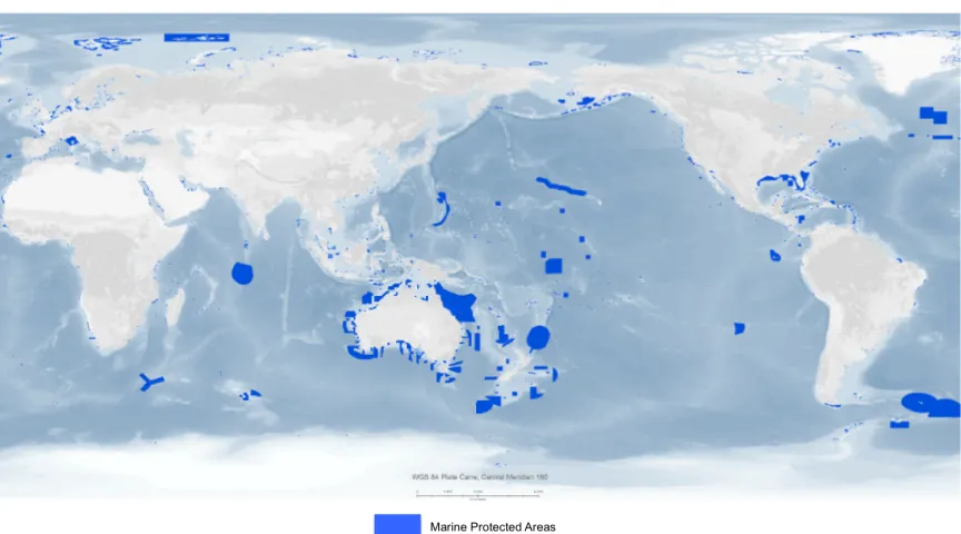
Figure 1. The World Database on MPAs ... 10
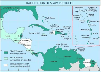
Figure 2 SPAW Protocol Ratification Status 2012 ... 29
Figure 3. Colombia’s National Protected Areas ... 35
Figure 4. MPAs in the Colombian Caribbean Region ... 38
Figure 5 Seaflower Biosphere Reserve location ... 40
Figure 6 The Seaflower MPA Location ... 41
Figure 7 General Ocean Circulations in the Wider Caribbean Sea ... 43
Figure 8 Coral reef areas within Seaflower Biosphere Reserve ... 45
Figure 9 The Seaflower MPA Administrative Division ... 48
Figure 10 Major shipping routes and Marine Traffic within the Caribbean Sea ... 50
Figure 11 Nicaragua Canal ... 51
Figure 12 Caribbean Colombian Oil and Gas exploitation blocks ... 59
Figure 13 Seaflower MPA and Colombia’s maritime boundary (ICJ Decision) ... 62
Figure 14 Malpelo Island PSSA ... 81
LIST OF ABBREVIATIONS
AFS Antifouling Convention
AIS Automatic Identification System ANH National Agency of Hydrocarbons APMs Associated Protected Measures
BR Biosphere Reserve
BWMC Ballast Water Management Convention CARs Regional Autonomous Corporations CBD Convention on Biological Diversity CCO Colombian Ocean Commission CEP Caribbean Environment Programme CLME Caribbean Large Marine Ecosystem project
CMS Convention on Migratory Species of Wild Animals
CO2 Carbonic Dioxide
CORALINA Regional Corporation for the San Andres Archipelago DIMAR General Maritime Directorate
EMB Ecosystem-Based Management EEZ Economic Exclusive Zone
EU European Union
FAO Fisheries and Agriculture Organization GDP Gross Domestic Product
GEF-LME Global Environment Facility-Large Marine Ecosystems Project GHG Green House Gas Emmissions
HSC Code High-Speed Craft Code
Hz Hertz (Frequency Unit)
ICM Integrated Coastal Management ICZM Integrated Coastal Zone Management IMO International Maritime Organization
INVEMAR Marine Research Institute and Coastal “Jose Benito Vives de Andreis”
IOC Intergovernmental Oceanographic Commission IUCN International Union for Conservation and Nature IUU Illegal, unreported and unregulated
IWC International Whaling Commission KMI Korean Maritime Institute
LCVs Large Commercial Vessels LMEs Large Marine Ecosystems
MAB UNESCO Man & Biosphere Programme
MADS Ministry of environment and Sustainable Development
MARPOL 73/78 International Convention for the Prevention of Pollution from Ships
MDGs Millennium Development Goals
MEAs Multilateral Environmental Agreements MPAs Marine Protected Areas
MSP Marine Spatial Planning
NGOs Non-Governmental Organizations NWG National Working Group
PCG Panama-Colombia Gyre
PSMM Pelagos Sanctuary Marine Mammals PSSA Particularly Sensitive Area
PSU Practical Salinity Units
SAMP Subsystem of Marine Protected Areas SAP Strategic Action Plan
SDGs Sustainable Development Goals SINA National Environmental System
SP Special Areas
SPAW Specially Protected Areas and Wildlife Protocol SPNN National Natural Parks System
TBMPAs Transboundary Marine Protected Areas TBPP Transboundary Protected Peace Park TSS Traffic Separation Scheme
UAC Environmental Coastal Units
UNCED United Nations Conference on Environment and Development UNCLOS United Nations Convention on the Law of the Sea
UNCTAD United Nations Conference on Trade and Development UNEP United Nations Environment Programme
UNESCO United Nations Educational Scientific and Cultural UNSD United Nation Sustainable Development Division VTS Vessel Traffic Services
WCMC World Conservation Monitoring Centre WCPA World Commission on Protected Areas WCR Wider Caribbean region
WHC World Heritage Convention
INTRODUCTION
In recent times, oceans have become more industrialized, facing several issues that generate conflict between economic and environmental protection values. For instance, the increase in shipping activities is causing issues such as increases in marine invasive species, as well as of CO2 emissions and underwater noise (IMO, 2012), which are causing massive losses of native ecosystems. Furthermore, drilling activities related to the exploitation of the seabed around the world are becoming increasingly common (ISA, 2008) as new technologies are developed in the industry.
Furthermore, transnational threats such as illegal fishing, piracy, drug smuggling, slavery and illegal migration are also contributing as stressors of the marine environment (Patrick & Storm, 2013). These transnational threats are contributing in some manner to marine pollution and consequently causing degradation of the marine environment (Van Tatenhove, 2013). Additionally, climate change effects are now more evident, degrading ecosystems such as coral reefs, causing migration of fish, and creating an imbalance in habitats (Harrould-Kolieb & Herr, 2012).
Therefore, the United Nations, through its specialized agencies, is making efforts to address these problems (UNSD, 2015). They have called for the participation of all responsible actors, i.e., member states, Non-Governmental Organizations (NGOs), the shipping industry, communities, and academia, to adopt the strongest measures in a cooperative manner to ensure the sustainable development of ecosystems for our future generations. Nevertheless, it must still be a requirement that the protection of biodiversity has a strong relevance at all levels of society.
As a result, several initiatives in marine governance have been put into play. At the end of the 20th century, the United Nations upgraded and updated the Convention on the Law of the Sea (UNCLOS) as a necessity to improve governance and protection of the environment (Jones, 2014). Operational activities in marine spatial planning (MSP) have emerged as a solution to address those problems through an enormous process of analysis to manage at both spatial and temporal levels, the distribution of human activities in the oceans (Vallega, 2001; 2002).
Furthermore, the improvement of cooperation mechanisms in the political process contributes to reaching environmental, social, and economic goals from coastal state jurisdictions including the exclusive economic zone (EEZ), especially in regional seas (Vallega, 2001; Osherenko, 2006; Van Tatenhove, 2013; Ehler, 2014). In addition, some states have assumed the leadership and started to approach conceptions of marine governance, focusing on marine and coastal protection, through the concept of Marine Protected Areas (MPAs).
This is where environmental institutions such as the Non-governmental International Union for Conservation of Nature (IUCN) and United Nations Environment Programme (UNEP) are playing an important role developing initiatives for improvement and guiding countries in the designation of these areas to facilitate and support the management process (Van Tatenhove, 2013; Jones, 2014; Wright, 2014; Marine Conservation Institute, 2015). They have also increased the level of protection to restrict some human activities as a mechanism to ensure the long-term conservation of ecosystems (Jones & Qiu W, 2011; Van Tatenhove, 2013; Jones, 2014).
Likewise, The International Maritime Organization (IMO) is doing its part in the protection of the environment from impacts of shipping activities through the establishment Particularly Sensitive Sea Areas (PSSAs) (IMO, 2006). It has been an effective solution in foreseeing the conservation of marine habitats through the establishment of exclusion zones or limiting specific shipping activities. This includes maritime navigation in high-risk traffic areas to tackling the degradation of marine habitats from the adverse effects of it. However, MPAs require strong enforcement, monitoring, and control measures, especially in developing countries, to succeed in the governance process.
pollution, and adverse wave making and underwater noise produced by propellers as an effect of maritime traffic. Moreover, an increase in seabed explorations might cause damage and pollution as well.
Therefore, The Seaflower MPA requires improvement of governance strategies at national and regional levels. Additionally, further special sensitive areas could be established as a measure against environmental threats around coral reef areas in the key islands.
CHAPTER I: MARINE PROTECTED AREAS GOVERNANCE
1.1 Background
Approximately two-thirds of the world’s surface is covered by water. Oceans, including the seabed and coastal areas, contain rich and diverse environments, fauna and flora, corresponding to 80% of Earth’s biosphere, some of which are key ecosystems for life on Earth (Plata, 2009). Nevertheless, these ecosystems are being threatened by anthropogenic activities causing significant degradation (Jones & Qiu W, 2011). Therefore, to ensure the heritage for future generations, they should be protected, preserved and managed appropriately. In that sense, MPAs have become a suitable solution for the protection of marine/coastal ecosystems (Jones, 2014).
1.1.1 Definitions
When discussing MPA governance, it is important to acknowledge some definitions surrounding this broad subject. Van Tatenhove (2013, p. 298) makes an extensive review of the existing literature and defines ocean governance as “… the rules of collective decision-making where there is a plurality of actors or organizations and where no formal control system can dictate the terms of the relationship between them”. Besides this, the concept encompasses a set of official rules involving formal and informal institutions and a negotiation process between them, which function at different levels to ensure effective integrated management. This concept leads to a policy-making process, sharing administration roles through many governing entities during a temporary period while the stabilization and organization of marine policy occurs.
To ensure effective ocean governance it is necessary to establish management strategies based on an ecosystem approach. Ecosystem-Based Management (EBM), have been defined since mid-1970s as “a conceptual framework incorporating human activities undertaken at sustainable levels as an accepted element of ecosystem functioning”. Nevertheless, in 1992 the concept took strong place for international environmental organizations and was defined as “a strategy for the integrated management of land, water and living resources that promotes conservation and sustainable use in an equitable way” (UNEP, 2014a, p. 20).
managed, through legal and other effective means, to achieve the long-term conservation of nature with associated ecosystem services and cultural values” (Dudley, 2008 as cited by Lausche (2011, p. 12)).
Both concepts, governance, and protected areas, involve a systematic process of setting rules within a particular zone, (i.e. marine) to exclude or limit commercial purposes and tackle degradation of oceanic ecosystems. This is managed by legal measures (policies) and also by formal agreements with the participation of all the intervening stakeholders through effective strategies to ensure the long-term preservation of the environment (Osherenko, 2006; Patrick & Storm, 2013).
As a result, IUCN-WCPA established a formal definition for MPAs: “any area of intertidal or subtidal terrain, together with its overlying water and associated flora, fauna, historical and cultural features, which has been reserved by law or other effective means to protect part or all of the enclosed environment” (Lausche, 2011, p. 14).
1.1.2 History of MPAs
The first country that used the concept of an MPA as a management approach was Australia when, in 1879, it created the Royal National Park in New South Wales. This MPA was composed mainly of land, following by estuaries and an open shoreline. After that, the United States started to lead in the field and in 1903 established the first MPA on Pelican Island. In 1913, an MPA system at Cabrillo National Monument in California was established. Subsequently, in 1935, a complete environmental MPA was put in place in Fort Jefferson, a subtidal area, to protect the Dry Tortugas coral reef (Jones, 2014; Tripp, 2014).
Nevertheless, in the following years, the development of MPAs was slow. However, the necessity to improve management methods and protection of marine ecosystems did take place, which is why, between the mid-1950s and early 1960s, there were several developments. In 1962, marine and coastal protection was discussed during the first World Conference on Nationals Parks, representing a significant formal step, toward adopting and developing the MPA concept globally (Jones & Qiu W, 2011). During the 1970s concern about environmental protection grew due to increasing technical capability in the exploitation of marine resources. On that basis, several conventions such as the Ramsar Convention (1971) and the World Heritage Convention (1972) were developed in the following years. Simultaneously, the United Nations Council created the UNEP as the first body in charge of monitoring and reviewing environmental issues at an international level. After the establishment of UNEP, there was a considerable advance in the development of MPAs, from 118 in the 1970s to 718 between the mid-1980s and early 1990s (Kelleher & Kenchington, 1992).
2.8% of ocean areas are under protection by 13,674 MPAs. This number is still is very low compared with the 15.4% of protected areas inland.
Nevertheless, MPAs coverage has grown because of awareness of the steady degradation that is being suffered by marine ecosystems such as coral reefs. This is especially true in tropical areas due to the increase in sea temperature as a consequence of climate change (Jackson, Donovan, Cramer, & Lam, 2014). Therefore, MPAs are considered an effective solution for the protection of those habitats that have been depleted due to unreasonable exploitation and impacts from anthropogenic activities (Jones & Qiu W, 2011). Nonetheless, MPAs effectiveness cannot be measured only by their designation; it is necessary to ensure effective protection measures.
Figure 1. The World Database on MPAs
Source: IUCN; UNEP-WCMC (2013)
1.2 WORLDWIDE MARINE GOVERNANCE
The exploitation of oceans through new technologies started taking place in the 1980s when the oceans became more industrialized, and transnational threats increased (Van Tatenhove, 2013) at the same time as shipping activities were increasing (Jones, 2014). Therefore, the impacts of pollution on the oceans are high, and marine ecosystems continue to suffer deterioration due to shortcomings of regulation, legislation and enforcement (Fanning, et al., 2007) worldwide. Thus, broader conceptions relating to governance have started to be developed rigorously (Vallega, 2001).
1.2.1 United Nations Convention on the Law of the Sea (UNCLOS 1982)
UNCLOS is the Umbrella convention of all international treaties developed since the mid-twentieth century (Vallega, 2001) and several changes were made up to the last update in 1982. As the mother of the international binding regulations, it deals broadly with all matters related to oceans including closed and semi-closed seas (Vallega, 2002). Furthermore, through these essential principles, it gives provisions to states regarding the rights and duties in the development of policies under EEZ jurisdiction, and on the high seas (Umana, 2002; Jones, 2014). Nonetheless, the interest of this analysis is to discuss the framework related to the conservation and management of marine resources focusing on MPAs under national jurisdiction.
UNCLOS part XII contains provisions related to the protection and conservation of the marine environment through sustainable development (UNCLOS, 1982). Furthermore, in other sections of the Convention, it establishes the duty of states to cooperate in relation to environmental matters (Van Tatenhove, 2013; Wright, 2014). Cooperation is the most important principle enforcing the convention because it is the appropriate mechanism wherein coastal states are accountable to undertake measures to deal with all transnational threats that are affecting and degrading the marine environment today. Besides it is necessary to work together with specialized organizations (Umana, 2002; Jones, 2014) to address the issues efficiently.
Moreover, taking into account UNCLOS, several UN specialized organizations started to develop a mechanism in matters concerning the protection of marine ecosystems. The main goal is to fill the interpretation gaps that the umbrella convention has, adapting to the challenges of the 21st century (Vallega, 2001).
In this regard, The IMO is addressing some mechanisms to protect the environment, through the establishment of special areas such as PSSAs (IMO, 2006) that are being affected by shipping activities (Van Tatenhove, 2013; Wright, 2014). The aim is to protect and preserve rare or fragile ecosystems in the long-term (UNEP, 2012; Jones, 2014). In this respect, States have demonstrated their concern to enhance the MPA approach, since 1992, in the global conference on environment and development.
1.2.2 United Nations Conference on Environment and Development (UNCED) – Agenda 21 (1992)
Agenda 21 is the result of the first steps that the UN undertook to reach the goals and priorities regarding sustainable development of the environment for the twenty-first century. This agenda was adopted during the Earth Summit (UNCED) in Rio de Janeiro, Brazil in 1992 with the participation of over 170 member states (UNSD, 2015).
The global alliance was developed with the aim of balancing and integrating environment and development as one concept to address several issues regarding the effects of anthropogenic activities such as climate change that can only be solved at the highest level of cooperation. To strengthen cooperation efforts, Chapter 2 of the agenda addressed these concerns by way of sub-regional, regional and international organizations stepping up sustainable development in developing countries to succeed in the long-term (UNCED, 1992; Lausche, 2011). However, its successful implementation has to be a responsibility of governments at a national scale through the execution of strategic action plans and policies within their territories.
Moreover, as was mentioned, section II leads with matters concerning conservation and management of resources for development. Specifically, Chapter 17 put emphasis on “protection of the oceans, all kind of seas, including enclosed, semi-enclosed seas, and coastal areas and the protection of rational use and development of their living resources” (UNCED, 1992, p. 168; Umana, 2002, p. 34).
As the concern is mainly related to sustainable use and conservation of marine living resources, it places emphasis on national jurisdictions, and their obligations and rights regarding preservation and rational use of their resources. Chapter 17 also sets rules concerning the sustainable development of fisheries and the management of related activities (UNCED, 1992). Therefore, it obligates coastal states to undertake measures to enforce preservation and restoration of their threatened ecosystems such as coral reefs, mangroves, and seagrass beds. Put simply, it encourages states to develop mechanisms to protect areas minimizing adverse impacts on the marine environment. This is when MPAs play a major role in doing so (Umana, 2002; Lausche, 2011).
working on specific environment-based management programs in coastal states and small islands jurisdictions (including EEZ) and high seas (Umana, 2002). The aim is to “integrate management and sustainable development; marine environmental protection; sustainable use, and conservation of marine resources addressing critical uncertainties within marine ecosystems like climate change, strengthening regional and international cooperation and coordination” (UNCED, 1992, p. 168).
Thanks to the commitment and contribution of member states supplying information related to the status of marine habitats and ecosystems, UNCED developed the World Ocean Assessment. This review provides analysis, evaluating the sustainability of oceans on how they have been managed at both global and regional levels (UNEP, 2014b). Nevertheless, these efforts for the protection of particular ecosystems are being supported by a convention related to protecting biodiversity and ecosystems.
1.2.3 Convention on Biological Diversity (CBD)
In that sense, the Convention imposes some obligations. Article 6 gives tools and provisions for governments regarding the integration of those strategies under national jurisdictions. Article 8 refers to in-situ conservation measures and gives provisions through the establishment of the protected areas system, enforced by domestic legislation, to preserve ecosystems against threats such as invasive and alien species, and degradation of those biotas by human activities (CBD, 1992). Finally, the adoption of these actions shall be taken through the involvement of local stakeholder communities to ensure the equitable allotment of benefits resulting from them (Umana, 2002; Lausche, 2011; CBD, 2016).
As compromises of the Convention, parties agreed to develop a regular meeting to review the SAP to manage and address governance. Therefore, in 1995 the Jakarta Mandate on Coastal and Marine Biodiversity was issued (Umana, 2002). It identifies five activities that parties shall implement under the scope of the convention referring to marine habitats. The activities are, integrated coastal management (ICM); sustainable use of coasts and marine living resources; implementing feasible mariculture; preventing invasion of alien species; and creating MPAs (Lausche, 2011).
Finally, the Secretariat of the CBD recently updated its SAP for the period from 2011 to 2020, focusing on 16 goals and specific targets (Jones, 2014; CBD, 2016). They are: to restore approximately 15% of degraded areas by implementing conservation activities through proper and efficient MPA designations, effectively managed in a global network, making a special effort in reducing stressors on coral reefs areas mainly related to fishing activities (Lausche, 2011; Jones, 2014).
1.2.4 Code of Conduct for Responsible Fisheries (FAO)
The code of conduct was an initiative of the Fisheries and Agriculture Organization (FAO) as a contribution to reach the objectives of the UNCED Agenda 21. The main purpose is to assist, especially, developing countries in the conservation, responsible management and development of all fisheries within its jurisdictions (FAO, 1995).
In addition, the code has one particular objective related to promoting “the protection of living aquatic resources and their environments in coastal and marine areas”(Art 2) (FAO, 1995, p. 2). Thus, the general principle of the code is to establish that all marine ecosystems and fishery habitats in a critical situation of depletion, degradation and pollution due to anthropogenic activities, should be protected and rehabilitated through a stronger mechanism. In this regard, MPAs are the mechanism that can deal with these issues through effective MSP implementation.
1.2.5 UNESCO Man and Biosphere Programme
United Nations, Scientific and Cultural Organization (UNESCO) established the Man and Biosphere (MAB) Program in the early 1970s. It is an Intergovernmental Scientific Programme with the objective of improving the affinity of the environment with people on a systematic basis (Umana, 2002; Lausche, 2011; UNESCO, 2015).
The program encompasses the designation of Biosphere Reserves (UNESCO, 2015) which by definition are “areas comprising terrestrial, marine and coastal ecosystems which are internationally recognized for promoting and demonstrating a balanced relationship between people and nature” (Kelleher, 1999 cited by Umana (2002, p. 35)).
National governments nominate areas that become biosphere reserves, but remain their sovereign jurisdiction. Nevertheless, the international status is recognized according to the Statutory Framework of the World Network of Biosphere Reserves (WNBR) (UNESCO, 2014). The aim is to promote solutions for the conservation of ecosystems with sustainable use. Therefore, the purpose of these areas, as a scientific basis, is preventing and monitoring through management, all changes attributable to interactions between humans and ecological habitats (UNESCO, 2015).
The MAB program has a strong connection with the Convention on World Heritage (WHC) due to the relevance of conservation for future generations. In some areas, this is through a cultural awareness such as the Great Barrier Reef in Australia, which has invaluable importance for humanity (Kelleher, Bleakley, & Wells, 1995). Today, the program manages a dynamic and interactive WNBR, which is mainly terrestrial but with an increasing number of maritime reserves. It is achieving a shareholder dialogue through the harmonious integration of people and environment with the objectives of reducing poverty, sharing knowledge, and respecting traditional beliefs to improve national welfare, besides facing the impacts of climate change using interdisciplinary research and innovate combinations for sustainable development (Umana, 2002; Lausche, 2011; UNESCO, 2015).
In that way, action plans have been developed to achieve the objectives of the program. Since 1995, the Seville Strategy suggests some solutions to reach sustainable development goals for the twenty-first century (UNEP, 2012). Likewise, as a result of the suggestions proposed in the Seville Strategy, the Madrid Action Plan was adopted in 2008. This plan joins the MAB and the WNBR in proposing an agenda to achieve their goals by 2013. Recently, this agenda was updated to continue reaching the goals for the following decade, until 2015, especially in the increase in MPAs (UNESCO, 2015).
biosphere reserves including the Seaflower Biosphere Reserve, the largest MPA in the Caribbean Sea (Taylor, Baine, Killmer, & Howard, 2013).
Furthermore, as part of the initiatives on environmental protection, the IMO sets provisions for the establishment of special areas threatened and degraded by the effects of shipping activities and ship-source pollution.
1.2.6 Special Areas (SP) and PSSAs under MARPOL 73/78
Since 1959, IMO as part of the UN system in charge of matters related to shipping and maritime safety, has assumed responsibility concerning pollution prevention, and its associated issues with the aim of mitigating the impacts on the environment as a consequence of maritime activities. There are over fifty binding agreements adopted by IMO to regulate shipping worldwide, out of which 21 encompass environmental concerns (IMO, 2016).
Recently, IMO through Resolution MEPC.200 (62) (IMO, 2016) updated and established new requirements for the designation of Special Areas. The success of those provisions takes effect by the commitment of the coastal states to notify and to improve adequate reception facilities (MARPOL Annex IV) on the borders of those special areas. The resolution entered into force on January 1, 2013.
The criteria for the designation of both PSSAs and special areas are not mutually exclusive since both points can be identified as parts of one another (Umana, 2002; IMO, 2016), and are developed taking into consideration provisions made by UNCLOS. The most up-to-date guidelines for the designation of PSSAs were adopted by Resolution A.982 (24) on December 1, 2005 (IMO, 2006). The management practices for enclosed and semi-enclosed seas apply this concept in an accurate manner (Plata, 2009; IMO, 2016).
The document sets the criteria that coastal states must fulfil to obtain the designation from IMO. The information required from the area to be designated, at least, should meet one of the three criteria. These include: ecological criteria (rarity or uniqueness), the importance of biodiversity in the ecosystem, its vulnerability and degradation by ocean phenomena and/or anthropogenic activities; socio-economic and cultural value (tourism), and scientific and educational or historical value (IMO, 2006). There are additional associated protective measures that states can undertake to manage maritime activities and guarantee the safety of navigation within the PSSA, such as traffic separation schemes (routing), and vessel traffic services (VTS).
hydrography and marine weather information (IMO, 2016). The above mentioned is valuable in the risk assessment plan that coastal states must have to execute a proper management and governance inside the PSSA (Umana, 2002; IMO, 2003; IMO, 2006).
Although, the effectiveness of PSSAs concept has not been truly proved due to different interpretation and application of the concept by states (Roberts J. , 2007). Nonetheless, the IMO aims to continue increasing the number of these particular areas and, for instance, increase the development of systems (e.g. VTS, AIS) through the e-navigation concept to minimize the impact on the environment by shipping activities (Umana, 2002). Therefore, to date, IMO has designated fourteen PSSAs around the world. Colombia is one of the states that has one under its jurisdiction with Malpelo Island (Pacific Ocean) (Plata, 2009; IMO, 2016).
Nevertheless, IMO has aligned its efforts to protect the marine environment according to the provisions made by the CBD (1992), and its current SAP with the objective to work together to reach the goal of protection of marine ecosystems (UNEP, 2016). There, regional environmental bodies start to play an important role in managing all the anthropogenic activities, including shipping-related ones, within regional sea areas.
1.2.7 UNEP Regional Seas Programme
comprehensive approach to combating environmental troubles through the management of marine and coastal areas” (Vallega, 2002, p. 734).
In 1984, after ten years of the program having been established the lessons learned were shared, and the UNEP encouraged a generation of policy frameworks by launching ten more Action Plans enveloping 140 coastal states (UNEP, 2012). The Caribbean Environment Programme (CEP) was the second having been established in 1981 (UNEP, 2014a). It is considered a postmodern approach for the regionalization of ocean governance because it provides the essential legal framework for conservation, including rules for the establishment of MPAs (Vallega, 2002; Lausche, 2011; Jones, 2014).
Today, the UNEP’s Regional Seas Programme leads 18 successful Multilateral Environmental Agreements (MEAs). The scope is based on cooperation and solidarity among states, improving Integrated Coastal Zone Management (ICZM) and MSP, and reducing land-based pollution. Additionally, it protects valuable ecosystems promoting the creation of MPA networks to tackle the impacts of ocean acidification and climate change on coral reefs, moving forward a green economy approach (Lausche, 2011; UNEP, 2014b).
1.2.8 New 2030 Agenda for Sustainable Development – SD Goals
The new 2030 Agenda is the update of all previous agendas (e.g. Rio+20) and the masterpiece of the UN action plans. The global aim for the next fifteen years is to work for the prosperity of people and planet eradicating poverty through sustainable development (UNSD, 2015). The Agenda pursues the Millennium Development Goals that encompass 17 goals and identify 169 associated targets approved by Resolution A/70/L.1, during the 70th session of UN General Assembly on October 21, 2015, and put into operation on January 1, 2016 (UNSD, 2015). The goals of sustainable development are integrated and indivisible, balancing three dimensions; economic, social, and environmental. These are developed through the cooperation of all countries and global partnerships through a collective consciousness for the well-being of current and future generations (Kaurobi, Espey, & Durand-Delacre, 2016). All the above is framed within international law provisions; for instance, countries agreed to enforce them at all levels, regional, sub-regional and national (UNSD, 2015)
This dissertation will focus mainly on the goals related to sustainable management of oceans and seas preserving and restoring ecosystems and biodiversity that suffer adverse impacts from climate change and anthropogenic activities.
In that sense, according to UNSD (2015), a specific goal is part of the discussion: Goal 14. “Conserve and sustainably use the oceans, seas and marine resources for sustainable development”. The targets that should be reached during the next fifteen years concern:
1. Reducing of all kinds of marine pollution;
2. Increasing sustainable management of existing MPAs;
3. Reducing the impacts of ocean acidification through scientific cooperation;
5. Increasing protection and conservation of coasts and marine areas through science advice by 10%;
6. Prohibiting irregular fishery subsidies, especially in developing and less developed countries;
7. Increasing the economic benefits from the sustainable exploitation of marine resources in Small Island Developing States (SIDS), and least developed countries.
All of the above will be achieved through enhancing the international binding regime for the conservation and sustainable use of oceans, increasing scientific knowledge capacity and, cooperating with scientific organizations for the wellbeing of developing countries.
The way forward to develop this important strategy is through a global solidarity partnership where all the stakeholders, governments, and communities are involved. Regarding sustainable ocean development, the aim is to tackle the degradation of ecosystems reducing the harmful impacts produced by all kinds of industrial activities. To achieve these, it is necessary that coastal states work hard on the designation of MPAs with the strongest governance strategy possible until 10% of the oceans are protected effectively (Jones, 2014; Wright, 2014). The agenda is very optimistic, but it is not impossible to accomplish.
Thus, it is necessary to continue working, focusing the regional level, and strengthening governance to achieve these global goals.
1.3 REGIONAL MARINE GOVERNANCE IN THE CARIBBEAN SEA
(Fanning, et al., 2007). To address environmental concerns on a regional basis, in 1974, the UN system created a regional program, as a response to UNCLOS part XII. The main purpose is to work together for the proper management and development of closed and semi-enclosed seas encompassing binding and non-binding agreements, i.e. Regional Seas Conventions and Action Plan (RSCAPs) (Lausche, 2011; UNEP, 2014a; UNEP, 2014b).
Referring to regional governance, it is necessary to define the concept of Regional Seas. The definition suggested by UNEP through the Regional Seas Programme is “conceived as a portion of the ocean within which the ecosystem merited protection, and also within which the development of coastal and islands states would benefit from the international cooperation” (Vallega, 2002, p. 727). Besides, it is important to take into consideration that ecosystems do not respect political borders. Therefore, it is necessary to consider that the nature of ecosystems is transboundary, i.e. across political boundaries. For instance, today regional governance based on the EBM Approach is taking place (Vallega, 2002; UNEP, 2014a).
The UN system recognizes the Caribbean Sea as one of the most unique and complex areas of the world. Its extension is over 2.5 million km2 ("The Caribbean Sea", 2015). It is geographically and politically diverse as it embraces 44 States and territories with over 100 maritime boundaries (UNEP, 2012; UNEP, 2014a; CEP, 2015). For that reason, to manage this vast area, several initiatives have been developed.
Kelleher, Bleakley, & Wells (1995), listed several initiatives and institutions that work in the Wider Caribbean for the protection of marine environment. However, many of them focusing on fisheries. There are only two biggest environmental protection programs concerning the whole area that today will be discussed. The first one is the Caribbean Environment Programme (CEP), and the other is Caribbean Large Marine Environment project (CLME).
1.3.1 United Nations Environment Programme - Caribbean Environment Programme – (UNEP-CEP)
The CEP was the second UNEP program established in 1982 with all its institutional components (Convention, Action Plan, Funds, and Coordination Unit), building one of the most valuable programs of the UN system. In addition to this, the CEP is recognized by the countries in the region for its high commitment to the development of environmental management initiatives (UNEP, 2014b).
Storm, 2013). Likewise, tourism and fisheries are the main activities in the zone and are sources of marine pollution. Furthermore, the Caribbean faces several political conflicts and presents diverse economies in terms of development, with significant influence of developed countries exerting colonial powers, and hosting many different languages (Patrick & Storm, 2013; Van Tatenhove, 2013; UNEP, 2014b).
To address all the above issues and challenges, in 1982, countries unanimously decided to work for the adoption of a cooperative and integrated approach through a convention for the protection and sustainable development of the Caribbean region (UNEP, 2012).
1.3.1.1 Convention for the Protection and Development of the Marine Environment in the WCR and its Protocols.
The Wider Caribbean Action Plan was the first step taken by CEP and countries to start to develop a binding agreement. As a result and through the commitment of the countries involved, it was possible to move forward to the adoption of the Convention for the Wider Caribbean, which was agreed in Cartagena de Indias, Colombia in 1983 (hereafter, the Cartagena Convention). This regional treaty entered into force in 1986. To date, 25 States have ratified it (Lausche, 2011; UNEP, 2012).
is necessary to apply regional ocean governance based on the effective EBM approach to ensure sustainability in the WCR (UNEP, 2012).
Following the adoption of the convention in 1983, two legal instruments were subsequently adopted. The first one was the Protocol concerning Cooperation in Combating Oil Spills in the Wider Caribbean Region (Oil Spills Protocol). This protocol and the convention itself were convened simultaneously. The second is the Protocol Concerning Specially Protected Areas and Wildlife (SPAW Protocol), which was adopted in the early 1990s and entered into force in 2000. The latter was the third program driven by UNEP with the aim of preserving and improving the marine ecosystem in the region (Lausche, 2011; UNEP, 2012; CEP, 2015).
Today, the SPAW Protocol has been ratified by only 16 states (UNEP, 2014a) (Figure 2), including Colombia. The aim is "to take necessary measures to protect, preserve and manage, in a sustainable way, zones that require protection to safeguard their particular value and that threaten or endanger species of flora and fauna" (Art. 3) (UNEP, 2012, p. 40).
Figure 2 SPAW Protocol Ratification Status 2012
Source: CEP (2015)
Although the number of MPAs is relatively small, in 2014, the Caribbean Regional Programme (CRP), under the umbrella of the SPAW Protocol, established the Caribbean Challenge Project (CEP, 2015). The objective is to enlarge regional MPAs up to 20% by 2020 through a sustainable governance mechanism based on cooperation between countries for the protection of the ecosystem in the larger Caribbean (UNEP, 2014a).
the largest in the region is the Seaflower MPA (Howard, 2006; CEP, 2015).
1.3.1.2 The Caribbean Large Marine Ecosystem (CLME) Project
CHAPTER 2: COLOMBIA’S CARIBBEAN COAST MPAs
2.1 Background
Colombia is the fifth-largest and most biologically diverse State in Latin America (Toro, Requena, & Zamorano, 2009; "US Commerce Office", 2011; OECD, 2014; Alonso, et al., 2015). Due to its strategic position, it shares waters in both the Caribbean and the Pacific oceans, corresponding to approximately 45% of the national territory (Minambiente, 2012). The Caribbean coast is the largest area, with approximately six thousand square kilometers and 1,300 kilometers of coastline (CCO, 2014; "Cancilleria Colombia", 2016). Its waters and coastal areas embody rich coral reefs, seagrass beds, mangroves, estuaries and coastal lagoons (The World Bank, 2006; "US Commerce Office", 2011; Minambiente, 2016).
Thus, the economy is based on ecosystem services, which have grown considerably in recent years, especially coastal and marine (Nolet, Vosmer, De Brujin, & Braly-Cartillier, 2014). Therefore, it represents 40% of the national GDP (OHI, 2015), of which commercial fishing, and small-scale artisanal fishing represent only 0.36% (Ramirez, 2016). Nevertheless, fishing is the core livelihood for coastal and islander communities. For instance, efficient management mechanisms and frameworks are necessary to protect its marine richness from anthropogenic activities. On this basis, Colombia has established coastal and marine conservation priorities (Alonso, F., Diaz, Segura, Castillo, & Anthony, 2007), through the establishment of MPAs to overcome the threats that are causing marine degradation (Ramirez, 2016).
2.2 National Governance and Framework on MPAs
Colombia’s environmental framework is considered one of the most comprehensive and the oldest in Latin America (Cajiao, et al., 2006; "US Commerce Office", 2011). All the principles and provisions for the protection and management of the natural resources and biodiversity are in the National Constitution of 1991 (Art 8, 63, 80, 102) (Minambiente, 2011; OECD, 2014). Colombia has also adopted and implemented international conventions and programs (Minambiente, 2011).
To guarantee the protection of the nation's natural patrimony, the government, has created several institutions since 1968. The Ministry of Environment (MADS) is in charge of managing and developing policies in matters concerning the protection of areas where natural resources are threatened and require special care (Cajiao, et al., 2006). To do so, more specifically, the National System of Natural Parks (SPNN), was created in 1974, and several pieces of legislation were adopted, taking into account the model used by the United States (Minambiente, 2012).
Likewise, extensive changes have occurred with the preparation and ratification of the CBD (Minambiente, 2011). Thus, in MPA governance, in 1993, it created the National system of Protected Areas (SINA), and the subsystem of Marine Protected Areas (SAMP). Furthermore, the government decentralized some management functions creating the Regional Autonomous Corporations (CARs) in charge of the administration and management of natural resources at regional level (OECD, 2014).
eleven national categories that correspond to four IUCN categories (Minambiente, 2012, pp. 9-10).
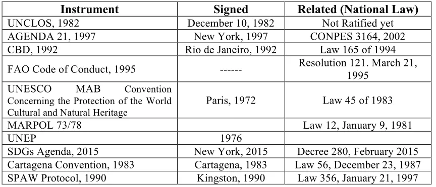
Table 1 International and Regional MPA’s mechanisms adopted by Colombia. Instrument Signed Related (National Law)
UNCLOS, 1982 December 10, 1982 Not Ratified yet
AGENDA 21, 1997 New York, 1997 CONPES 3164, 2002
CBD, 1992 Rio de Janeiro, 1992 Law 165 of 1994
FAO Code of Conduct, 1995 --- Resolution 121. March 21, 1995
UNESCO MAB Convention
Concerning the Protection of the World Cultural and Natural Heritage
Paris, 1972 Law 45 of 1983
MARPOL 73/78 Law 12, January 9, 1981
UNEP 1976
SDGs Agenda, 2015 New York, 2015 Decree 280, February 2015
Cartagena Convention, 1983 Cartagena, 1983 Law 56, December 23, 1987
SPAW Protocol, 1990 Kingston, 1990 Law 356, January 21, 1997
Source: Minambiente (2011)
Table 2. IUCN PA's Classification and Categories
IUCN
Category Scope of Application Main MPA Objective
I (Strict managed for science or wilderness Nature/Wilderness area) PA protection
Restore Ecosystems; enhance MPA Network/MSP; Cultural value of set-aside areas; Management tourism/recreation its impacts; cultural symbolic value
II (National Park) PA managed for ecosystem protection and recreation Restore Network/MSP; control the impacts of ecosystems; enhance MPA tourism/recreation
III (National Monument) PA managed for conservation of specific natural features Promote research and education
IV (Habitat/Species Management Area) PA for conservation based on management intervention
Protect rare and vulnerable habitats and species
V (Protected managed for conservation and recreation Landscape/Seascape) PA Maintain traditional uses; cultural values of set-aside areas
Nevertheless, reviews of the earlier legislation identified a few deficiencies. For instance, in 2010, the government clarified definitions of protected areas and their categories. It also established coordination mechanisms and defined the criteria, procedures and responsible actors for designation, administration, and management of the MPAs (Minambiente, 2011). As a result, it created the Unique Registry of Protected Areas (RUNAP) to consolidate the inventory of PAs based on the type of governance, classified in public and private law, at the national and local level, based on the IUCN categories and objectives. Furthermore, the legislature is working on developing a law to include communitarian and stakeholder governance in the protected area system (Minambiente, 2012).
This governance approach has been implemented in Colombia since 2001, and it is being developed in the national bio-cultural regions, including the Caribbean (De Pourcq, Thomas, Arts, Vranckx, Leon-Sicard, & Van Damme, 2015). There was an innovative mechanism executed by the MADS to ensure management and conservation of biodiversity within PAs in the territory.
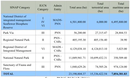
According to RUNAP, Colombia has protected approximately nine percent of its total marine area (7,854,381.83 ha) (Figure 3) (PNNC-RUNAP, 2016). Likewise, national MPAs are classified into six categories (Table 3).
Table 3. Information of National MPAs - SINAP Categories
Source: PNNC-RUNAP (2016)
On the other hand, geographically the marine jurisdiction of Colombia is divided into the following regions: Tropical Atlantic and East Tropical Pacific, within which three provinces are found, two in the Caribbean and one in the Pacific. The Caribbean provinces are the Caribbean Sea province and the province of the Archipelago of San Andres, Providencia and Santa Catalina (Figure 3) (CORALINA-INVEMAR; Gómez- López, D. I.; Segura-Quintero, C.; Sierra-Correa, P. C.; Garay-Tinoco, J., 2012; INVEMAR, 2016).
SINAP Category IUCN Category
Admin
Entity Total area (ha)
Total terrestrial area (ha) Total maritime area (ha)
National District of integrated management Seaflower Biosphere Reserve I IV VI
MADS-PNN 6,501,800.00 6,000.00 6,495,800.00
Park Via III PNN 56,200.00 27,315.47 28,884.53
Regional Natural Park II PNN -
CARs 405,195.30 405,156.40 38.90
Regional District of
Integrated Management VI
MADS -
CARs 4,129,038.10 4,124,013.10 5,025.00
National Natural Park II PNN -
CARs 11,049,941.71 10,699,432.31 350,509.40
Sanctuary of Fauna and
Flora III PNN 1,048,629.26 74,505.26 974,124.00
Figure 3. Colombia’s National Protected Areas
2.3 Coastal and Marine MPAs in the Caribbean Coast of Colombia
The Colombian Caribbean Sea is located in the northern part of South America. The Caribbean coast extends 1,932 km, with a marine jurisdiction of 532,154 km2 (CCO, 2014); the portion of submerged coastal zone is 7,673 km2 (INVEMAR, 2016). This includes the extension of the continental margin in the insular area of San Andres and Providencia (Figure 4).
The governors of eight continental departments, one insular department, twelve environmental authorities and nine harbor masters, in charge of environmental management, complicate the governance in the region. This system deals with 84% of the total coastal population of the country (INVEMAR, 2016). Likewise, these authorities manage six Environmental Coastal Units (UAC), and the Caribbean Oceanic Environmental Unit defined by the MADS through Decree Law 1120 in 2013 (Minambiente, 2015; Alonso, et al., 2015; INVEMAR, 2016).
As the country has embraced its extensive biodiversity, the Caribbean coast underpins vast ecosystems of coral reefs, seagrass beds, mangrove forests, coastal lagoons and estuaries, which cover a total of 561,235 ha (Alonso, et al., 2015). The coral reefs are the biggest area (over 52% of total) followed by coastal lagoons and estuaries. Over six thousand marine species in the Caribbean have been recorded. However, only 16% of these marine ecosystems are included under 23 MPAs (Figure 3) (INVEMAR, 2016; PNNC-RUNAP, 2016).
(CORALINA-INVEMAR; Gómez- López, D. I.; Segura-Quintero, C.; Sierra-Correa, P. C.; Garay-Tinoco, J., 2012)
Figure 4. MPAs in the Colombian Caribbean Region
CHAPTER 3. Case Study: THE SEAFLOWER MPA 3.1 Background
Colombia's constitutional mandate considers the preservation and conservation of its unique ecosystems and areas of ecological importance, and is respectful of the obligations prescribed in the international environmental treaties to which it is party (Minambiente, 2011). The government, in 1998, proposed the designation of the archipelago of San Andres, Providencia, and Santa Catalina, and the surrounded marine area, as a biosphere reserve (Figure 5) to be known as the Seaflower Biosphere Reserve (Minambiente, 2005). Later in 2000, UNESCO included it within the MAB World Biosphere Network (Howard, 2006).
Moreover, in January 2005, the MADS through Resolution 107, declared an MPA, within the biosphere reserve (Minambiente, 2005), the largest in the Caribbean Sea, and the first of its category in Colombia (Howard, 2006; UNEP, 2010; CORALINA-INVEMAR; Gómez- López, D. I.; Segura-Quintero, C.; Sierra-Correa, P. C.; Garay-Tinoco, J., 2012; Taylor, Baine, Killmer, & Howard, 2013).
Figure 5 Seaflower Biosphere Reserve location
Source: The Author – Software QGIS
Despite the legal designations made by Colombia’s environmental institutions and those accorded by international bodies to protect the ecosystems and to manage the activities within the area, it is still threatened and jeopardized by several issues, mainly shipping-related. Further, boundary disputes, with the neighbouring country Nicaragua, due to the judgment of the International Court of Justice (ICJ) might be damaging the integrity of the entire ecosystem within the biosphere reserve as well as the MPA (Gorricho, 2012; De Rivaz, 2013; CORALINA, 2014).
3.2 Geographical position
cays and atolls) (Figure 6). The origin of the formation of islands, cays, and atolls was caused by volcanic formations as a result of fracture zones associated with the Nicaragua Rise (Diaz, Diaz-Pulido, Garzon-Ferreira, Geister, Sanchez, & Zea, 1996). The largest island, San Andres is 800 km (480 NM) north-west of the Colombian continental territory (UNEP, 2010; Murillo & Ortiz, 2013). The MPA Area covers a maritime area of 65,000 sq.km, with only 1% of the terrestrial surface (650 sq.km.) (UNEP, 2010). The population of over 100,000 base their livelihood on artisanal fisheries and tourism (Howard, 2006). The MPA is part of the Caribbean coral reef hotspot, which is among the richest areas in marine species diversity, but also one of the most threatened (Howard, 2006). For instance, the area is considered to be of regional and national ecological significance.
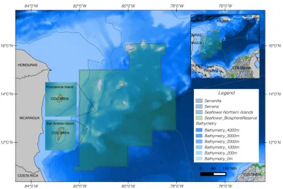
Figure 6 The Seaflower MPA Location
3.3 Oceanographic conditions
Due to its location within the Wider Caribbean Region, the archipelago has a continual east-to-west flow of currents from the Atlantic Ocean (Figure 7) which, considering the marked changes in bathymetry, divide the Caribbean current between the islands, forcing the stream to deviate to the south. The flow, which collides with the continent, recirculates in the area, forming the Colombia-Panama Gyre with an average velocity of 1m/s, which by the effect of winds, creates a long wave fetch (Andrade C. , 2000; CORALINA-INVEMAR; Gómez- López, D. I.; Segura-Quintero, C.; Sierra-Correa, P. C.; Garay-Tinoco, J., 2012).
Figure 7 General Ocean Circulations in the Wider Caribbean Sea
Adaptation from: Taylor, Baine, Killmer, & Howard (2013); Ruiz-Ochoa (2011)
3.4 Marine Ecosystems
The coral reef is the key ecosystem for conservation in the MPA because as one of the largest in the Caribbean, it represents about 14% of the world’s coral reefs (UNEP, 2005), the second in the western hemisphere, and most productive in the region (UNEP, 2010). The reef extension covers approximately 2,000 km2 (Taylor, Baine, Killmer, & Howard, 2013), and is composed of two barrier reefs, five atolls, reef lagoons, and coral banks (Howard, 2006), which is 78% of the national total (Figure 8) (CORALINA-INVEMAR; Gómez- López, D. I.; Segura-Quintero, C.; Sierra-Correa, P. C.; Garay-Tinoco, J., 2012).
Figure 8 Coral reef areas within Seaflower Biosphere Reserve
3.5 MPA Objectives
Colombia set, through the National Law 99/93 (Alonso, et al., 2015), overall targets for the MPAs in the territory, based on the global IUCN objectives (Lausche, 2011; Speed & Levine, 2014; Jones, 2014). Moreover, the Seaflower MPA has defined its objectives with the participation of islander communities, and stakeholders based on the concept of community-based management (Howard, 2006; De Pourcq, Thomas, Arts, Vranckx, Leon-Sicard, & Van Damme, 2015) to ensure effective governance and protection of the ecosystems in the zone. Moreover, to succeed in achieving the activities within the MPA, five core objectives were defined (Coralina, 2005):
1. Preservation, recovery, and long-term maintenance of species, biodiversity, ecosystems, and other natural values including special habitats;
2. Promotion of sound management practices to ensure long-term sustainable use of coastal and marine resources.
3. Equitable distribution of economic and social benefits to enhance local development.
4. Protection of rights concerning historical use.
5. Education to promote stewardship and community involvement in planning, and
management.
3.6 MPA Zoning
The MPA is divided into three administrative sections, established through Accords 021, and 025 (Coralina, 2005), seeking a better implementation of the biosphere reserve. Therefore, the areas are: Northern (37,522 km2), Central (12,716 km2), and Southern (14,780 km2) (Figure 9). Moreover, within the administrative divisions, there are five zone types for in-situ conservation and sustainable use (Howard, 2006; Taylor, Baine, Killmer, & Howard, 2013):
1. No-entry (116 km2), preservation zones restricted only for research and monitoring activities;
2. No-take (2,214 km2), conservation zones that incorporate and allowing non-extractive uses;
3. Recovering and sustainable use of marine resources (2,015 km2), allows traditional artisanal fishing activities, and artisanal sport fishing and all the activities allowed in the special use, no-entry and no-take zones;
4. Special use (68 km2), shipping related, leisure, and waters sports;
Figure 9 The Seaflower MPA Administrative Division
Source: The Author – Software QGIS
3.7 Threats to the MPA in the region
Vallega (2002), UNEP (2005), Lopez & Krauss (2006), Fanning, et al. (2007), Biggs (2009), Morris (2012), and UNEP (2014a) have described the threats and issues concerning the marine ecosystems in the Caribbean region, and thus, they are not different for this MPA.
2005). Moreover, today, new challenges concerning shipping activities have emerged as a consequence of on-going and short-term developments in the region. In addition to IUU fisheries and boundary disputes that are affecting and threatening the link of the unique ecosystems within the Seaflower MPA, the following developments are of concern.
3.7.1 Increase in Maritime Traffic
About 90% of global trade is moved by seagoing vessels (IMO, 2012), and keeping pace with global economic development, shipping has grown by 30% over a period of four to five years (AGCS, 2014), increasing routes and connectivity. For instance, according to UNCTAD (2015), Latin America and the Caribbean have the highest liner shipping connectivity with Panama. To date, 21 vessel operators connect with the US directly through the Panama Canal, which is the crossroad between east-west and north-south routes, followed by Mexico, Jamaica, and Colombia. Thus, the Panama Canal expansion will allow regional expansion of ports, and therefore, larger vessels transiting through the Caribbean. Likewise, the proposed Nicaragua Canal will be another development in the region that will bring more pressures and, thus, impacts on the Seaflower MPA ecosystems.
3.7.1.1The Panama Canal Expansion