SEISMICITY OF HIMALAYA VIS-À-VIS TECTONICS
AND FOCAL MECHANISM
Kathuria Sukriti
1, Bhan Uday
21,2
Department of Petroleum Engineering & Earth Sciences,
University of Petroleum and Energy Studies, (India)
ABSTRACT
The active continent- continent collision between Indian and Eurasian plates have given rise to mighty
Himalaya which separates the Tibetan plateau in the north from Indo-Gangetic plain in the south. This active
collision since 65 million years has produced variety of geological features in the region in the form of large
thrust faults running into several thousands of kilometers and many transverse features. The region has high
earthquake productivity with four great earthquakes in a span of 53 years between 1897 and 1950 and many
large earthquakes. It has been found by researchers that great and major earthquakes in the Himalaya occur on
the northward dipping (with a dip of about 5-10) seismically active segment of detachment (Seeber et al.,
1981;Ni and Barazangi, 1984;Molnar,1990). The small and moderate magnitude earthquakes are confined in a
narrow belt, referred to as Himalayan Seismic Belt (HSB), which is around 50 km wide, which may be marked
by 20-30 degree dip. In this study an earthquake catalog for the past 50 years is prepared; focal mechanism of
all significant earthquakes is collected from various sources and a seismo-tectonic map of Himalaya is prepared
with all major features which are digitized. The seismicity is studied with respect to geological features, focal
mechanism.
Keywords: Focal mechanism of Himalaya, Seismicity of Himalaya.
I. INTRODUCTION
Himalayan range extends from northwest to southeast in a 2400 kilometer stretch, separating Indo-Gangetic in
south from Tibetan plateau in north.
1.1 Evolution of Himalayan Range
Indian subcontinent, a part of Gondwana island was separated from Eurasian plate by Paleotethys ocean during
the late Precambrian and Paleozoic period. Pan African orogeny affected the northern part of Indian marks the
unconformity between Ordovician continental conglomerates and underlying Cambrian marine sediments. The
Cimmerian superterranes drifted away from Gondwana towards north. During Norian, gondwana got rifted apart
in two parts- east and west. India, a part of east gondwana along with Australia and Antarctica, separated in
India, later broke off from Australia and Antarctica in early Cretaceous. In Upper Cretaceous, Indian plate
started drifting in north direction where oceanic-oceanic subduction took place, followed by oceanic crust
subducting below Tibetan block. This orogeny is active, thus many geologic relationships can be demonstrated
deliberately. Collision processes have produced a variety of geologic features such as large scale thrust, strike
slip and normal fault systems, widespread volcanism , regional metamorphism and formation of intracontinental
and continental margin oceanic barriers.. It has been inferred that the evolution of Himalaya have played a
critical role in global climate change. (Ruddiman & Kutzbach 1989, Molnar et al 1993, Quade et al 1995,
Harrison et al 1998a, cf. Ramstein et al 1997)which ultimately altered the dynamics of the Himalayan-Tibetan
orogenic belt(Beaumont et al 1992) and its growth (Avouac & Burov 1996). The large-scale interaction between
tectonic and climate potentially makes studies of the Himalayan-Tibetan orogen of greater significance.[1] In the
last three decades, many geological and geophysical investigations have been carried out in the Himalaya
region, and have provided many insights into the
Figure 1: Ridges and Faults Across Indo Gangetic Plain
[2]overall geologic evolution of the Himalaya (Chang & Zheng 1973; Dewey & Burke 1973; Alle`gre et al 1984;
Molnar 1984; Tapponnier et al 1986; Dewey et al 1988, 1989; Burchfiel & Royden 1991; Harrison et al 1992,
1998a; Molnar et al 1993; Zhao et al 1993; Avouac & Tapponnier 1993; Hsu et al 1995; Nelson et al 1996;
Owens & Zandt 1997; England & Molnar 1998; Larson et al 1999; Xu et al 1998.)
There are numerous traversing faults and ridges through Himalayan range which are:
Delhi-Haridwar ridge, Faizabad ridge, Munger- Saharsa, Son Narmada fault, West Patna fault, Karakoram fault,
Lucknow fault, Moradabad fault, Great Boundary fault, Dhabri fault, Pinga and Kishangarh fault.
The Delhi Haridwar ridge is the extension of Delhi Aravali fold belt. These ridges comprises of granitic and
1.2 Stratigraphic Divisions of Himalaya
Himalaya is divided into four tectonic divisions namely, Sub-Himalaya, Lesser-Himalaya, High-Himalaya and
Indus Suture Zone (ISZ). The Sub-Himalayas are composed of Miocene to Pleistocene molassic sediments,
derived from erosion of Himalaya, forms its foothill. The Sub- Himalayas are still a very active orogeny, which
thrusts along Major Frontal Thrust over Quaternary alluvium deposited by rivers coming from Himalaya. The
Lesser Himalaya sediments thrust over sub Himalaya along Major Boundary Thrust. [3]
The High Himalayas are the areas of high topographic relief, forming the backbone of Himalayan orogeny.
Sediments forming HHCS (High Himalayan Crystalline Sequence) are of late Proterozoic to
early Cambrian age, comprises of medium to high grade metamorphic sequence of metasedimentary
rocks.Indus Suture Zone (ISZ) marks the line of collision of Indian plate and Ladakh Batholith; and the northern
limit of Himalaya.
Figure 2: Stratigraphic Divison of Himalayas
[4]1.3 Seismicity
Major earthquakes occur on the northward dipping(with a dip of about 5-10)seismically active segment of
detachment in Himalayas [5][6][7]. The small and moderate magnitude earthquakes which are straddling on the
surface trace of MCT, are confined in a narrow belt. Himalayan Seismic Belt(HSB) is seen as the downdip edge
of the locked seismically active detachment or simply the transition zone. It may be marked by 20-30 degree
dipping mid-crustal ramp, between the seismically active detachment to the south and the aseismically slipping
detachment to the north (Pandey et al., 1995.). The dormant character of these Himalaya thrusting at shallow
depths is testified by lack of Seismicity around the exposed MBT and HFT.
The most important seismotectonic zones are:
i. Sulaiman-Kirthar Seismotectonic Belt (SKSB),
ii. Hindukush-Karakoram Siesmotectonic Belt (HKSB),
iv. Himalayan Frontal Thrust Seismotectonic Belt (HFTSB),
v. Transverse Seismotectonic Zones (TSZ) viz., Aravali Range, Delhi-Haidwar Ridge, Faizabad
ridge,Mongyr-Saharsa ridge,and Nawabganj Intra-cratonic High (NIH),
vi. Dauki Fault Zone(DFZ),
vii. Bengal-Arakan Seismotectonic Belt (BASB),and
viii. Deccan Intraplate Seismotectonic Zone (DISZ)
These seismotectonic belt/zones are depicted in the seismotectonic map of Himalayan region which is based on
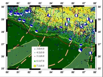
the data collected from USGS from 1964 to 2009 (Fig 3,4,5).
II. FIGURES
Figure 4: Central Himalayan Region
III. METHODOLOGY
This project work includes,
Digitizing all faults along the Himalaya and transverse ridges:
All the faults along the Himalayas namely,
Main Frontal Thrust(MFT);
Main Boundary Thrust(MBT);
Main Central Thrust(MCT)
Indus Tsangpo Suture(ITS);
South Tibetan Detachment(STD);and
Indus Suture Zone(ISZ).
Major Ridges traversing along Himalayan belt, namely
Delhi-Haridwar Ridge;
Munger- Saharsa Ridge;
Faizabad Ridge.
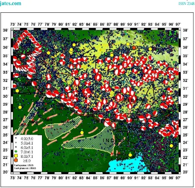
Collection of catalog of earthquakes and information about focal mechanism of earthquakes in Himalaya:
Earthquake’s epicenter data from 1964 till 2000 are collected and mapped. They are classified into the
following divisons based on their magnitude:
Figure 6:
Himalayan Region Fault Plane Solution and Seismic Distribution
IV. CONCLUSION
Seismicity along Himalayas is primarily due to the collision of Indian and Eurasian plates. Earthquakes are
concentrated all along a narrow belt called Himalayan Seismic Belt(HSB) which is around 50km wide. There is
clustering of earthquakes (low to medium magnitude) along the ridges situated in Indo-Gangetic plain namely,
Delhi-Haridwar Ridge, Faizabad ridge, Munger Saharsa ridge. Pamir Hindukush region homes strike slip faults
and some normal faults. Large numbers of earthquakes are also observed in the north eastern Himalaya with
strike slip mechanism. Earthquakes also cluster along Indo-Myanmar subduction with strike slip and few with
normal fault mechanism.
The earthquake epicenters in Himalaya generally follow the srike of Himalaya with greatest concentrations of
seismic activity occurring along the Hindu Kush and Pamir mountain ranges, and near the Quetta, Kashmir and
Assam syntaxes. Throughout Tibet, however, the distribution of epicenters is rather irregular and no clear trends
are apparent. Two aseismic lineaments, one west of the Sulaiman Range and the other in the Assam Valley, are
identified. The seismic activity in the vicinity of the Counter Thrust (Indus-Tsangpo Suture zone) is rather
V. ACKNOWLEDGEMENT
For the completion of my work, I owe my gratitude to Ministry of Earth Sciences and my mentor Dr. Sumer
Chopra for helping unconditionally throughout the intern. Also, I express my gratitude to Dr. K.S Mishra and
Dr. Uday Bhan for supporting me and the University Of Petroleum And Energy Studies for giving me the
platform to showcase my talent.
REFERENCES
[1] Yin, An ;Harrison T. M.2000 ,GEOLOGIC EVOLUTION OF THE HIMALAYANTIBETAN OROGEN,
Department of Earth and Space Sciences and Institute of Geophysics and Planetary Physics, University of
California.
[2] Godin, L.; Harris, L.B. Tracking basement cross-strike discontinuities in the Indian crust beneath the
Himalayan orogen using gravity data – relationship to upper crustal faults, Geophys. J. Int. (2014).
[3] Frank, W.; Gansser, A.; Trommsdorff, V. (1977). "Geological observations in the Ladakh area
(Himalayas); a preliminary report". Schweizerische Mineralogische und Petrographische Mitteilungen
Bulletin 57 (1): 89–113.
[4] Yin, An (May 2006). Cenozoic tectonic evolution of the Himalayan orogen as constrained by along-strike
variation of structural geometry, exhumation history, and foreland sedimentation .Earth-Science
Reviews 76 (1–2): 1-131. Bibcode:2006ESRv...76....1Y.doi:10.1016/j.earscirev.2005.05.004. ISSN
0012-8252.
[5] Molnar, P. (1990). A review of the seismicity and the rates of active thrusting and deformation at the
Himalaya, J. Himalayan Geol. 1, 131–154.
[6] Seeber, L., J. G. Armbruster, and R. Quittmeyer (1981). Seismicity and continental subduction in the
Himalayan Arc, in Himalaya-Geodynamik Evolution, H. K. Gupta and F. M. Delany (Editors),
Geodynamik Series 3, American Geophysical Union, Washington, D.C., 215–242.
[7] Ni J, Barazangi M (1984) Seismotectonics of the Himalayan collision zone:geometry of the
under-thrusting Indian plate beneath the Himalayas. J Geophy Res 89:1147–1163.
BIBLIOGRAPHY
Achache, José; Courtillot, Vincent; Xiu, Zhou Yao (1984). Paleogeographic and tectonic evolution of
southern Tibet since Middle Cretaceous time: New paleomagnetic data and synthesis. Journal of
Geophysical Research 89 (B12): 10311–
10340.Bibcode:1984JGR....8910311A. doi:10.1029/JB089iB12p10311.
Arora, B.K.; Gahalaut, V.K.; Kumar, N. 2012.Structural control on along-strike variation in the
seismicity of the northwest Himalaya. Journal of Asian Earth Sciences.
Besse, J.; Courtillot, V.; Pozzi, J.P.; Westphal, M.; Zhou, Y.X. (18 October 1984). Palaeomagnetic
estimates of crustal shortening in the Himalayan thrusts and Zangbo Suture .Nature 311 (5987): 621–
Besse, Jean; Courtillot, Vincent (10 October 1988). Paleogeographic maps of the continents bordering the
Indian Ocean since the Early Jurassic. Journal of Geophysical Research 93(B10): 11791–
11808. Bibcode:1988JGR....9311791B. doi:10.1029/JB093iB10p11791.ISSN 0148-0227.
Bingham, Douglas K.; Klootwijk, Chris T. (27 March 1980). Palaeomagnetic constraints on Greater
India's underthrusting of the Tibetan Plateau.
Nature284 (5754):.Bibcode:1980Natur.284..336B. doi:10.1038/284336a0.
Definition of Himalayas. Oxford Dictionaries Online. Retrieved 9 May 2011
Dèzes, Pierre (1999). Tectonic and metamorphic Evolution of the Central Himalayan Domain in
Southeast Zanskar (Kashmir, India) . Mémoires de Géologie. Doctoral thesis (University of
Lausanne) 32: 149. ISSN 1015-3578.
Ding, Lin; Kapp, Paul; Wan, Xiaoqiao (6 May 2005).Paleocene-Eocene record of ophiolite obduction and
initial India-Asia collision, south central Tibet. Tectonics 24 (3):
TC3001.Bibcode:2005Tecto..24.3001D. doi:10.1029/2004TC001729.
Klootwijk, Chris T.; Gee, Jeff S.; Peirce, John W.; Smith, Guy M.; McFadden, Phil L. (May 1992). An
early India-Asia contact: Paleomagnetic constraints from Ninetyeast Ridge, ODP Leg
121. Geology (Geological Society of America) 20 (5): 395–
398.Bibcode:1992Geo....20..395K. doi:10.1130/0091-7613(1992)020<0395:AEIACP>2.3.CO;2.
Klootwijk, C.T.; Conaghan, P.J.; Powell, C.McA. (October 1985). The Himalayan Arc: large-scale
continental subduction, oroclinal bending and back-arc spreading. Earth and Planetary Science
Letters 75 (2–3): 167–183. Bibcode:1985E&PSL..75..167K. doi:10.1016/0012-821X(85)90099-8.
Le Pichon, Xavier; Fournier, Marc; Jolivet, Laurent (1992). Kinematics, topography, shortening, and
extrusion in the India-Eurasia collision. Tectonics 11 (6): 1085–
1098.Bibcode:1992Tecto..11.1085L. doi:10.1029/92TC01566.
Molnar P and Tapponnier P, 1978,Active tectonics of Tibet, Journal of Geophysics, 83,5361-5375
Patriat, Philippe; Achache, José (18 October 1984). India-Eurasia collision chronology has implications
for crustal shortening and driving mechanism of plates. Nature 311 (5987): 615–
621. Bibcode:1984Natur.311..615P. doi:10.1038/311615a0.
![Figure 1: Ridges and Faults Across Indo Gangetic Plain[2]](https://thumb-us.123doks.com/thumbv2/123dok_us/9245504.1460513/2.595.77.516.311.608/figure-ridges-faults-indo-gangetic-plain.webp)
![Figure 2: Stratigraphic Divison of Himalayas[4]](https://thumb-us.123doks.com/thumbv2/123dok_us/9245504.1460513/3.595.77.514.286.531/figure-stratigraphic-divison-of-himalayas.webp)