ScholarlyCommons
Publicly Accessible Penn Dissertations
Summer 8-12-2011
Mobility and Variation in Chalcolithic North
Gujarat, India (Ca 3600 – 1800 Bc)
Suzanne Harris
University of Pennsylvania, suzanne.h.harris@gmail.com
Follow this and additional works at:http://repository.upenn.edu/edissertations Part of theArchaeological Anthropology Commons
This paper is posted at ScholarlyCommons.http://repository.upenn.edu/edissertations/359
For more information, please contactlibraryrepository@pobox.upenn.edu.
Recommended Citation
Harris, Suzanne, "Mobility and Variation in Chalcolithic North Gujarat, India (Ca 3600 – 1800 Bc)" (2011).Publicly Accessible Penn Dissertations. 359.
1800 Bc)
Abstract
Nine relatively obscure sites in the northern plain of Gujarat, India: Loteshwar, Santhli, Datrana, Nagwada, Langhnaj, Zekhada, Ratanpura and Kanewal; demonstrate a broad range of material culture traditions present in this region throughout the fourth through second millennia BC. This diversity results from the numerous economic strategies employed by the inhabitants of this region, the most important of which is mobility. Most of the sites reviewed in this work are the remains of temporary occupations, which are usually ascribed to pastoral nomads. Although pastoralism was an important subsistence strategy, a closer examination of the material culture and features at these sites shows there was a spectrum of approaches to mobility, which were related to different economic strategies. This work will show that despite many similarities, these sites do not represent a homogenous set of pastoralist camps. Instead, they document manifold activities, reflected through the uses of material culture and space.
Degree Type
Dissertation
Degree Name
Doctor of Philosophy (PhD)
Graduate Group
Anthropology
First Advisor
Gregory L. Possehl
Second Advisor
Holly Pittman
Third Advisor
Lauren Ristvet
Keywords
Archaeology, Gujarat, Antiquities, Prehistory, India, Indus Civilization
Subject Categories
Archaeological Anthropology
MOBILITY AND VARIATION IN CHALCOLITHIC NORTH GUJARAT, INDIA (ca 3600 – 1800 BC)
Acknowledgements
All long journeys require guidance, companionship and support. Mine could not have been completed without the generous help of many fellow travelers. First, this work would not exist if I had not been accepted as a doctorate student at the Department of Anthropology at the University of Pennsylvania, where Dr. Gregory Possehl was my advisor. It has been a genuine honor to study under the tutelage of one of the most prolific scholars in South Asian archaeology. I would also like to thank the other members of my committee, Dr. Lauren Ristvet and Dr. Holly Pittman, who generously contributed their attention and considerable expertise towards
helping me create this finished work. Other professors who have encouraged my intellectual development over the years are Drs. Harold Dibble and Gautam Ghosh.
Most of the research I conducted is based on the large volume of work produced by the faculty of the Department of Archaeology and Ancient History, Maharaja Sayajirao University of Baroda in Vadodara, Gujarat. I was first introduced to this department by Dr. Vasant Shinde, of Deccan College Post-Graduate Research Institute, with whom I had worked at Gilund for two seasons and owe him a debt of gratitude for taking me on my first tour through Gujarat. I am privileged to have had a long working relationship with this institution and its passionate and dedicated
particularly value the time I have spent with Kajal Shah (a most excellent road trip companion) and Rajesh S. V. (who is not only one of the most generous people I have ever met, but he also proves it is possible to share a brain with someone born on the other side of the world).
Archaeology is a notoriously expensive pursuit and my work would not have been possible without the support of my department and the American Institute of Indian Studies. In the fall of 2002 I received a travel grant from my department to visit the Maharaja Sayajirao University of Baroda and Deccan College to determine the feasibility of a dissertation project in Gujarat. In 2005, the AIIS awarded me with a Junior Fellowship, which allowed me to collect the bulk of my data. Extended residency in another country is a daunting experience, even for a seasoned archaeologist, and I will always appreciate Purnima Mehta’s calm, welcoming presence. Upon my return in 2006, the University of Pennsylvania granted me a Zwicker Fellowship to support the writing phase. In October 2009, I received additional travel money from my department for a supplementary and ultimately beneficial research period back in Vadodara. I was able to visit the re-excavation of Loteshwar as a guest of Drs. P. Ajithprasad and Marco Madella, whom I thank for being such gracious hosts.
where I decided that I wanted to dedicate the next several years of my life to its study. An internship at Archaeological Services Consultants in Columbus, Ohio honed my technical skills. Everyone there was extremely kind about letting a new student learn the trade and particular appreciation goes to Linda Whitman, Al Tonetti and Annette Ericksen.
At Penn, the friendship of my peers has created a warm, empathetic
atmosphere in the often isolating environment of graduate school. The other students of my advisor have been particularly good company and they are still the first people I still approach for advice: Shinu Abraham, Praveena Gullapalli, Christopher
Thornton, Teresa Raczek and Uzma Rizvi. Many others have been confidants and collaborators: Kristen Gardella, Kyung-Nan Koh, Adam Leeds, Catherine van de Ruit, Puskhar Sohoni and Aram Yardumian. I like to believe I have spent my time in Philadelphia wisely by making friends outside my department, whom I value
immeasurably: Donna Andrews, Rebecca Flynn-Meketon and Betsy Winter Hall have all provided good times and good advice. Michael Alexandre is my technology guru. I am overjoyed to have Dr. Ilene Grossman-Bailey as both a close friend and a role model.
Archaeologists who specialize in South Asia are an exceptionally genial lot and I honestly look forward to conferences to socialize rather than to keep up with current research. Among the evolving cast of characters I have had the pleasure of keeping extended company with are: Brad Chase, August Costa, Savitha
ABSTRACT
MOBILITY AND VARIATION IN CHALCOLITHIC NORTH GUJARAT, INDIA (ca 3600 – 1800 BC)
Suzanne H. Harris
Gregory L. Possehl
Nine relatively obscure sites in the northern plain of Gujarat, India:
Loteshwar, Santhli, Datrana, Nagwada, Langhnaj, Zekhada, Ratanpura and Kanewal; demonstrate a broad range of material culture traditions present in this region
throughout the fourth through second millennia BC. This diversity results from the numerous economic strategies employed by the inhabitants of this region, the most important of which is mobility. Most of the sites reviewed in this work are the remains of temporary occupations, which are usually ascribed to pastoral nomads. Although pastoralism was an important subsistence strategy, a closer examination of the material culture and features at these sites shows there was a spectrum of
MOBILITY AND VARIATION IN CHALCOLITHIC NORTH GUJARAT
Table of Contents
Acknowledgements iv
Abstract viii
List of Tables xii
List of Figures xiii
Chapter One: Introduction 1
Research Objectives 6 Defining Variation Among Occupations 10
Indices of economic variation in the archaeological record 13
Defining Mobility 14
Mobility and Pastoral Nomadism 15 Interrelationships between mobile and sedentary populations 16
Indices of mobility in the archaeological record 20
Summary of Chapters 26
Chapter 2: Research Methodology 26 Chapter 3: Geography and Ecology 26 Chapter 4: Historical and Cultural Contexts 27
Chapter 5: The Archaeology of North Gujarat 28 Chapter 6: Discussion and Conclusion 28
Chapter Two: Research Methodology 29
A History of Research in North Gujarat 29 1890s–1940s: Preliminary Surveys and Excavations 29 1950s and 1960s: Continuing Work 31
1970s and 1980s: Broad Surveys and Problem – Focused Projects 33 1990s–2000s: Focus on North Gujarat 35
Interpretive Themes in the Archaeology of North Gujarat 36
Pastoralism 37
Regional Cultural Development 38 Connections to the Indus Civilization 39
Archaeological Methodology in India 42
Data Collection 43
Chapter Three: Geography and Ecology of Gujarat 45
Historical Geology 45
Soils 46
Precipitation 47
The Regions of Gujarat 48 Delineating boundaries 50
Saurashtra 50
South Gujarat 51
North Gujarat 52
North Gujarat 52
Drainage 52
Dunes of North Gujarat 55
Flora 57
Paleoclimate and subsistence change in North Gujarat 58
Summary 60
Chapter Four: Historical and Cultural Contexts 61
Mesolithic Phases 66
Neolithic Period 69
Early Harappan and Transitional Phases in Pakistan and India 70 Defining the Early Harappan Phase 71
1. A note about the term “Early Harappan” 71 2. Regional aspects of Early Harappan Chronology:
Possehl (1999) and Wright (2010) 72 Early Harappan Material Culture 76 1. Early Harappan Beads 76 2. Kot Dijian Pottery 77
3. Amri-Nal Ware 81
The Early Harappan Phase in Gujarat 85 1.The role of subsistence practices in material distribution 85
2. Evidence for the Early Harappan Phase in Gujarat 86 Early Chalcolithic Populations in Gujarat 90 Sedentary Settlements 92
Mobile Camps 93
Material Culture of Early Chalcolithic Gujarat 94 1. Pre-Prabhas Ware 93 2. Micaceous Red Ware 97
3. Padri Ware 99
4. Anarta Ware 101
Mature Harappan / Urban Phase Occupations within Gujarat 106
Sindhi Harappans 110
1. Rohri chert 111
2. Sindhi Harappan ceramics 112
Sorath Harappans 114
1. Sorath Harappan ceramics 115 Late Harappan / Post-Urban Phase of Gujarat 117
Beads 121
Ceramics 123
Chapter Five: The Archaeology of North Gujarat 133
Introduction 133
The Excavated Archaeological Sites of North Gujarat 136
Loteshwar 136
Santhli 154
Datrana 168
Moti Pipli 180
Nagwada 199
Langhnaj 220
Zekhada 232
Ratanpura 241
Kanewal 250
Concluding Remarks 263
Chapter Six: Discussion and Conclusion 264
Patterns in Material Culture 266
Ceramics 266
Beads 269
Miscellaneous Artifacts 272 Patterns among Features 274
Burials 274
1. Non-Harappan burials 275 2. Early Harappan – affiliated burials 275 Structures and Pits 284
Activities 284
Subsistence Practices 284
Craft Activities 285
Degrees of Mobility 286 Most mobile occupations 286 Intermediately mobile occupations 287 Most sedentary occupations 287 Degrees of material diversity 288 Least diverse assemblage 288 Intermediately diverse assemblage 288 Most diverse assemblages 289 Changes over Time 291 Relative Chronology of pottery 291 Relative Chronology of other materials 292 Elaboration of residential architecture 293
Conclusion 294
LIST OF TABLES
LIST OF FIGURES
Chapter 1: Introduction
Figure 1.1 Regions of Northwestern South Asia 1
Figure 1.2 Chalcolithic Archaeological Sites in Gujarat 4 Figure 1.3 Archaeological Sites in North Gujarat 5
Chapter 2: Research Methodology
Figure 2.1 Map of Early Harappan Sites in Cholistan 41
Chapter 3: Geology and Ecology of Gujarat
Figure 3.1 Drainage Map of Gujarat 47 Figure 3.2 Regions of Gujarat 49 Figure 3.3 Drainage Map of North Gujarat 54
Chapter 4: Historical and Cultural Contexts
Figure 4.1 Early Harappan cultural regions 74 Figure 4.2 Early Harappan Terracotta Biconical Beads 76 Figure 4.3 Kot Dijian Wares 78 Figure 4.4 Distribution of Kot Dijian Wares 80 Figure 4.5 Amri-Nal Ware 82 Figure 4.6 Distribution of Amri-Nal Ware 84 Figure 4.7 Vessels from Moti Pipli and Nagwada 88 Figure 4.8 Sites with Early Harappan Pottery in Gujarat 89 Figure 4.9 Map of Early Chalcolithic Sites in Gujarat 91 Figure 4.10 Pre-Prabhas Ware 96 Figure 4.11 Micaceous Red Ware 98 Figure 4.12 Padri Ware 100 Figure 4.13 Anarta Ware 102 Figure 4.14 Urban Phase Sites in Gujarat 109 Figure 4.15 Rohri chert blades 112 Figure 4.16 Iconic Sindhi Mature Harappan ceramics 113 Figure 4.17 Sorath Harappan pottery 116 Figure 4.18 Post-Urban sites in Gujarat 119 Figure 4.19 Areca-nut-shaped Beads 122 Figure 4.20 Ahar BRW from Ahar 125 Figure 4.21 Lustrous Red Ware 128 Figure 4.22 Ahar Black and Red Ware Stud Handled Bowls 131
Chapter 5: The Archaeology of North Gujarat
Figure 5.1 Map of North Gujarat Sites 135 Figure 5.2 Loteshwar Contour Map 137 Figure 5.3 Loteshwar Trench Section 139 Figure 5.4 Loteshwar Ornaments 143
Figure 5.6 Loteshwar Anarta Ware Motifs 149 Figure 5.7 Contour Map of Santhli 155 Figure 5.8 Santhli Water Buffalo Skulls 157 Figure 5.9 Santhli Trench Section 158 Figure 5.10 Santhli Burials 160 Figure 5.11 Santhli Early Harappan Burial Vessels 164 Figure 5.12 Map of Datrana Mounds 169 Figure 5.13 Datrana Trench Section Showing Bone Clusters 171 Figure 5.14 Chert Blades from Datrana with Retouching 172 Figure 5.15 Pre-Prabhas Ware from Datrana 175 Figure 5.16 Anarta Ware from Datrana 176 Figure 5.17 Contour Map of Moti Pipli 181 Figure 5.18 Moti Pipli Trench Section Showing Pits 183 Figure 5.19 Moti Pipli Beads 185 Figure 5.20 Moti Pipli Bangles 188 Figure 5.21 Moti Pipli Early Harappan Ware 192 Figure 5.22 Moti Pipli Anarta Ware 193 Figure 5.23 Nagwada Contour Map 200 Figure 5.24 Nagwada trench section 201 Figure 5.25 Nagwada burial urn 203 Figure 5.26 Nagwada site plan 204 Figure 5.27 Nagwada Seals 208 Figure 5.28 Nagwada Early Harappan Ware 210 Figure 5.29 Nagwada Anarta Ware 212 Figure 5.30 Nagwada Mature Harappan Ware 214 Figure 5.31 Map of Langhnaj 221 Figure 5.32 Langhnaj Burials 224 Figure 5.33 Langhnaj Pottery 227 Figure 5.34 Zekhada Site Plan 233 Figure 5.35 Zekhada Pottery 237 Figure 5.36 Contour map of Ratanpura 242 Figure 5.37 Ratanpura Huts 243 Figure 5.38 Ratanpura Pottery 246 Figure 5.39 Kanewal Lake 251 Figure 5.40 Kanewal site plan 252 Figure 5.41 Kesarsingh’s Khetar 254 Figure 5.42 Sai no Tekro 256 Figure 5.43 Kanewal Pottery 260
Chapter 6: Discussion and Conclusion
MOBILITY AND VARIATION IN CHALCOLITHIC NORTH GUJARAT
CHAPTER ONE: INTRODUCTION
Introduction
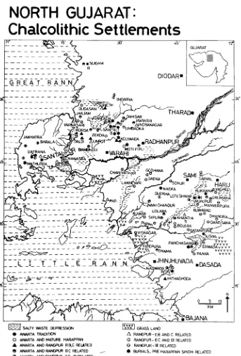
Nine relatively obscure sites in the northern plain of Gujarat, India (Figures 1.1, 1.2): Loteshwar, Santhli, Datrana, Nagwada, Langhnaj, Zekhada, Ratanpura and
Kanewal;demonstrate a broad range of economic strategies practiced in this region throughout the fourth through second millennia BC (Figure 1.3). These are expressed through the kinds of features found at sites and diversity of material assemblages. This diversity results from the numerous economic strategies employed by the inhabitants of this region, the most important of which is mobility. Most of the sites reviewed in this work are the remains of temporary occupations, which are usually ascribed to pastoral nomads. Although pastoralism was an important subsistence strategy, a closer
All Chalcolithic period sites in North Gujarat have been found through village to village surveys and are usually less than three hectares large. Most had small surface scatters of artifacts and brief test excavations revealed shallow deposits (no more than 60cm) (Bhan 1994:83). Concomitant with small habitation areas is a lack of architecture or constructed features, suggesting most sites were fleetingly occupied, though some deposits are substantial enough to indicate periodic reoccupation. The best sources of information on these kinds of sites are the excavations of nine sites in North Gujarat, dating from the fourth through second millennia BC (Figure 1.2 Archaeological Sites in North Gujarat). Enough variation exists among this sample in size and features to indicate a spectrum of mobility patterns.. The artifact assemblages reflect a variety of material culture traditions influencing local patterns of production and consumption. Such a conclusion can be drawn through the kinds of objects recovered and the range of styles discernable within each type. Artifact diversity also indicates the geographic and temporal breadth of economic networks associated with an occupation. The site data generated two heuristics – mobility and variation - which articulate how the past is reconstructed in this work.
Research objectives
regions (Allchin 1977; Bhan and Shah 1990; Ghosh 1965; Guha 1994; Joshi et al. 1984; Leshnik 1972; Possehl 1979, 1999; Subbarao 1958; Wright 1986). The analysis presented here demonstrates how North Gujarat contained a high degree of material cultural
diversity compared to other areas of Chalcolithic South Asia. For example, geographically distinct areas such as the foothills of the Aravallis and Baluchistan supported relatively homogenous cultural complexes1. This study shows that although many of the inhabitants of North Gujarat followed similar subsistence practices and used similar objects, they cannot be considered as as belonging to a single cultural tradition as defined through ceramics and other artifact types.
The specific focus on small scale sites and populations is different from the agendas of more traditional studies on South Asian archaeology from the fourth through second millennia BC. Those studies often concentrate on the Indus Civilization and evidence for its technological, economic and social complexity. However, restricting interpretations of the past within the walls of urban centers does not provide a broad representation of interaction patterns within the greater landscape. This study provides information on how this is expressed in the past through material culture traditions and occupational histories of excavated sites. It investigates economic connections among small camps on their own terms – not as subsumed into a greater Early or Mature Harappan ecumene but as places that had some, but not necessarily consistent, connections with these systems.
1
This project also interrogates the notion of a distinct cultural tradition specific to North Gujarat, marked by a diagnostic ceramic corpus known as Anarta Ware. An Anarta cultural tradition is typically correlated with following phenomena:
1) Presence of Anarta Ware and/or Early Harappan Red Ware 2) Small settlement size / ephemeral nature of settlements 3) Burials containing Early Harappan pottery
4) Presumably pastoral economy 5) Production and use of microliths
The presence of Anarta Ware and microliths within the same occupation are generally considered to be diagnostic fossils of a pastoralist population in North Gujarat. This reductive concept of an Anarta Cultural Complex warrants closer review2. Two questions are raised by this notion: Are Anarta Wares accompanied by a distinct suite of artifacts? Do all sites containing Anarta Wares reflect the same behavioral and economic patterns? As a means to test this notion, other kinds of artifacts and their relative
frequencies across sites are examined to determine if Anarta Wares are accompanied by a suite of material culture. But ultimately there are no easy correlations between artifacts and populations. Thus differences among sites are better determined through activity patterns and how they are expressed through the kinds of objects found and their occupational features. Scholars working in this region tend to emphasize the similarities among these small sites in order to reconstruct the development of mobile pastoralism in
2
the region. However, closer examination reveals there are significant differences among these sites that demonstrate manifold economic strategies rather than a single form of pastoral nomadism.
This work also demonstrates that information can be gleaned through a fine-grained analysis of the material culture from small sites with regard to their residential and economic functions. Studies of the Chalcolithic phases of Western India are often dominated by work on Indus Civilization cities and larger settlements. Yet this only covers one part of the past; many people lived at the extremes or outside of Indus
influence. The presence of Indus imports at the very small camp sites of North Gujarat is an important clue to how the occupants were linked, formally or informally, into greater economic networks. However, it is equally important to understand these sites within their own context, by studying their interrelationships. This study uses material culture and features to reconstruct the range of material culture traditions in circulation
Defining Variation Among Occupations
“Culture,” “variation” and “diversity” are complicated concepts in
anthropological theory. A discussion of how these terms are used in ethnographic literature is not productive in this work due to the enormity of the topic. Instead, this study employs an archaeological approach to differences among occupational phases at sites, an approach fundamentally based on analyses of material culture. In disciplinary parlance, the term “cultural variation” within a single site commonly refers to the range of artifacts and styles present during a particular occupation3.
Variety is a difficult concept to establish. It is usually defined according to differences between raw materials, manufacturing processes, and styles (as defined within a single artifact type). Among these indices, “style” is the most problematic as the term has different meanings and applications in archaeological scholarship. The
influential approaches to style of J. R. Sackett (1977) and Robert Dunnell (1978) demonstrate two common assumptions: 1) that style is a characteristic manner of doing something and 2) that this manner is peculiar to a specific time and place. However, as Stephen Plog (1978:334) explains, if we adhere to the idea that social differentiation is reflected in style, we make the following false assumptions. First, production patterns are assumed to be non-random and therefore always intentional. Second, stylistic variation is thought of as a result of different functions and activities, not individual choices or
3
circumstances. Finally, it is believed that production methods are consistently transmitted within specific social groups (such as families or kin-based organizations).
The use of ethnographic analogy may help overcome these assumptions and may help us to understand how multiple social processes contribute to the perception of “style.” Ethnoarchaeological approaches to style demonstrate the complexity of social and technological processes that culminate in what a researcher interprets as a style (Clark 1968; David and Kramer 2001; Hodder 1983; Miller 1985; Watson 1977; Wiessner 1983; Zagarell 1999). Based upon a comparison of ethnographic studies, Nicholas David and Carol Kramer (2001:219) conclude that style should be understood “as a relational quality, the potential for which resides in those formal characteristics of an artifact that are acquired in the course of manufacture as the consequence of the exercise of cultural choice.” In order to differentiate between recognizably different styles, a typology must be constructed. However, typology construction can be even more problematic than the definition of style.
related ceramic fabrics. It was coined in the early 1990’s (Ajithprasad and Sonawane 1993). Anarta Wares had been found in excavations published before Ajithprasad and Sonawane’s work, such as at Surkotada (Joshi 1990), but because no concise term existed for the non-Harappan pottery found at that site, the generic term “coarse regional ware” appears in the report. This term is also used in the original Zekhada reports (Parikh 1976, 1977; IAR 1977-78) but the connection between Surkotada and Zekhada was not made until after the excavations at Nagwada and Loteshwar. In short, typological distinction of style is different for both producers and consumers, and cultural meanings are always variable.
which those materials were utilized within an occupation. In this work, variation within an artifact assemblage is not meant to be used as a proxy for cultural affiliation,4 it is meant to show the range of interactions and activities present within a particular occupational phase. For example, an occupation that has several distinct types of ceramics indicates the inhabitants participated in a relatively wide-scale interaction network. A settlement that has many kinds of objects (for example, a combination of lithics, terracotta objects, ornaments, vessels, food processing equipment, etc. as at Moti Pipli) demonstrates a wide range of economic activities. A site with a narrower artifact inventory (such as the preponderance of lithics and little else as at Langhnaj)
demonstrates specific activities.
Indices of economic variation in the archaeological record
The metric for variation used here is the range of artifacts in terms of both object types (tools, ornaments, ceramics) and distinctive styles within each object type (with particular regard to ceramics). Particular attention is paid to ceramic diversity as wares specific to time periods and regions are good indicators for chronology and economic networks. Their relative frequencies within an assemblage are also important because they show which kinds were preferred by inhabitants. If a site has a large number of objects of a certain type (beads or bangles, for example), the frequencies of materials are also noted as these too indicate economic networks. Within the heuristic of “variation,” a
4
site with very few kinds of objects and a limited style repertoire is regarded as having low material diversity (and hence limited kinds of economic activities). One with a broad range of artifacts and styles (such as bead varieties) is considered to have high material diversity. This attention to diversity of occupational functions, as expressed through material culture, is directly related to mobility because mobility is an economic strategy, one that partially reflected by patterns in material culture.
Defining Mobility
For the purposes of this study the term “pastoral nomadism” refers to an economy based on animal herding over large geographic areas. However, nomadism is not always indicative of pastoralism and pastoralists are not by definition nomadic. The uncoupling of the terms “nomad” and “pastoralism” is well founded within the fields of
Mobility and Pastoral Nomadism
Virtually all reconstructions of prehistoric nomadic pastoralist populations are based on ethnographic analogy. It is essential here to include a cautionary note from David Clarke on the application of direct analogy (1968:13): “We must certainly try to find out the social and historical equivalents of our archaeological entities and processes but we should not delude ourselves about the simplicity of these equivalents or our success in isolating them.” Uncritical use of analogy may create poorly conceived interpretations but ethnography still provides useful templates for the kinds of spatial settlement patterns and object types common to different societies with similar sizes and behavioral patterns.
Discussions of pastoral nomadism typically emphasize the role of the
environment in shaping economics and social organization. A common theme in these works is that most subsistence activity is focused on procuring resources that are
predictably available during a particular season (Frachetti 2008). Nomadic communities use multiple strategies to secure resources. Many anthropologists and archaeologists reject the categorization of nomads as a specific community type because all
populations as habitually settled in finite spaces. These groups, however, are not
necessarily discrete and their relationship merits further examination. That is to say, that one community can have both nomadic and sedentary components.
Interrelationships between mobile and sedentary populations
A traditional anthropological model for pastoral nomadism comes from the Near and Middle East (Adams 1981; Bernbeck 1992; Cribb 1991a, 1991b; Kohler-Rollefson 1992; Zagarell 1989) where pastoralists are described as economic specialists that originally exploited marginal ecological areas not suitable for agriculture. The
ethnographic studies of Frederik Barth (1961) and Philip Salzman (1980) are landmarks that articulate the relationships between mobile and sedentary groups (particularly
between pastoral nomads and agriculturalists). In systematically mobile groups, strategies for producing and acquiring artifacts are more restricted than in sedentary communities (Schiffer 1987:43). The concept of change in subsistence practice as an adaptive strategy, e.g. to environmental and/or political pressures, is a common theme in discussions on the relationship between mobility and sedentism.
theory as originated by Emmanuel Wallerstein (1974, 2004), incorporates the notions of “Great and Little Traditions” (Redfield 1956:53, 70-1) and is best represented by the works of Anatolii Khazanov (1990, 1994). The second model proposes nomads as conduits of culture within a greater interaction network. In this sense they are viewed as established within a greater collection of interdependent social groups that range in scales. This model can be called the interstitial model and the works of Robert Kelly (1983, 1992) most fully capture this notion. The essential difference between these two perspectives is the peripheral model characterizes relationships between nomads and sedentary peoples as hierarchical; the interstitial model proposes this relationship is symbiotic.
The peripheral model rests on an essential distinction between a diffuse mobile population and a politically centralized sedentary population. The relationship between the two indicates a degree of symbiosis but at the “fringes” of the sedentary population, both geographically (particularly couched in terms of marginal environments unsuitable for agriculture) and socially. For example, Khazanov focuses on processes of
far enough in helping us understand why, over the centuries and millennia, peaks and valleys occur in the intensity levels of the local food system.” They emphasize the role of the state in regulating and organizing these relationships with references to “traditions” circulating within a much greater socio-economic system.
In an interstitial model, nomads are viewed as fluid agents within, rather than at the edges of, a greater system of social and economic interactions, some of which may be coordinated or administered by a centralized political authority. They are essential
conduits/perpetuators/maintainers/agents in the transmission of knowledge over large geographies. This approach emphasizes nomads and nomadic pastoralists in terms of their integration with larger sedentary groups5. Focus has shifted away from conceiving of nomads as marginal to seeing them as living in the “space between,” interdigitated with communities that occupy more finite and discrete territories. As Kelly states (1992:50), “the interstices between horticultural societies are frequently filled with nomadic foragers or pastoralists” as well as mobile merchants and wage labor. There are a number of contexts within which interactions can take place including gift exchange, trade, fairs, ceremonies, tribute, patronage and kinship (Swayam 2006:75). For example, Emanuel Marx’s (2007:76) ethnographic observations of modern Bedouin demonstrate the degree to which they are embedded in the urban market economy, which in turn affects their social organization and domestic economies6.
5
It owes a theoretical debt to Richard Fox’s notion of a “professional primitive” (1969) but he refers specifically to symbiotic relationships between foragers and settled communities.
6
Both models are employed within South Asian archaeology. The peripheral model is frequently employed in discussions of the Indus Civilization, often defined by its centralized political presence (as manifested through civil engineering and administrative tools). In contrast, the interstitial model is generated from studies of small temporary camps, with special regard to their interaction patterns with larger settlements, and is the perspective preferred here. Ethnographic analogies to modern pastoralism in the northern plains of Gujarat are used as models for interaction and a conduit for communication among all the sedentary communities of Gujarat (Allchin 1977:139; Possehl 1979, 2002a; Bhan 1989:232; Panda 2002, Swayam 2006). One of the earliest and most direct
expressions of the interstitial model appears in the article “Pastoral Nomadism in the Indus Civilization: A Hypothesis” (Possehl 1979), which notes that “pastoral nomads, or other highly mobile (itinerant) occupational specialists filled the interstices in the
Harappan settlement pattern” (Possehl 1979:547). Gregory Possehl’s characterization of nomadic-sedentary relations emerges from recognition of the “empty spaces” between larger sites. Both Possehl’s work in Saurashtra (1980) and Rafique Mughal’s Cholistan survey (1990, 1997) show that not only was the ancient landscape filled with hundreds of small settlements, but also that most of these sites are very small, ephemeral camps. This dissertation demonstrates what can be learned about the communities that inhabited them through archaeological indices of mobility and material variation.
Indices of mobility in the archaeological record
Archaeologists employ multiple approaches to determine the degree of mobility or sedentism apparent at a site through its artifacts and features. The first approach is to concentrate on identifying artifact types diagnostic of nomadic or sedentary communities and their methods of production. For example, Masson (1990:206) describes the material culture of pastoral nomads as a radical departure from the objects and technologies used by sedentary populations. Some of the materials needed include easily transportable shelter, specific vessel types and materials (particularly wood and leather) and special kinds of clothing (supple shoes, long trousers). However, one major problem with distinguishing “signatures” in material culture is the role of trade and other forms of interaction (Gamble 1991). As Lawrence Leshnik posits (1968), in such a case there will be a degree of shared material culture. Nomads often have no distinct artifact “styles”, thus particular categories or types cannot be the sole index through which cultural variation is determined. Since artifact variation presents interpretive ambiguities when used as a sole indicator of what kind of mobility strategy was employed by a group, a better method to distinguish mobility patterns is to incorporate the kinds of activities that took place at a particular site, namely subsistence and industrial practices, into an
The second, and in this case more useful, form of evidence used to determine mobility is economic activity analysis. Ethnographic studies by Binford (1978, 1980, 1990) have established relationships between artifacts, modes of production and mobility. Quite a bit of work exists in this vein, particularly with regard to lithic production (Kent 1984, Schott 1986). Some activities, such as agriculture or industries reliant on advanced pyrotechnology, are associated with sedentism and full-time residency. Others,
particularly resource acquisition (such as at a mine) and pastoralism, are generally associated with mobile groups.
ponds7. Cattle have lower water requirements and sheep and goat still less. Floral consumption differs as well; water buffalo and cattle eat grasses, requiring pasture land. Goats eat thorny scrubs, which allows for a much larger territory to roam.
Herd size can indicate the necessary amount of labor, accommodations and resources needed for maintenance. The range of mobility is proportional to herd size. The larger the herd, the greater the area the pastoralists must cover. Estimations of herd size vary widely with species, topography and resource constraints. It also depends on which commodities and services the livestock produce8. For example, a modern Brahui in Baluchistan considers the optimal herd size for sheep (per single shepherd with a sheepdog) to be 500 heads (Spooner 1973). In contrast, nuclear families of Bedouin are secure with 18 female camels. These two communities practice nomadic pastoralism to fulfill entirely different economic and social needs and this is reflected by their livestock.
.
The third type of evidence used to determine mobility is analysis of features that indicate temporary occupations such as ephemeral housing materials (Madella 2003:228, Swayam 2006), the manner in which they are organized (Varma 1991:292) and the taphonomic processes that affect them (Smiley 1979-80:163)9. When interpreting
7
This has interesting implications considering the increased consumption of water buffalo during the later occupations of the Mature Harappan phase (Chattopadhyaya 2002:394).
8
For example, in Gujarat prior to Independence, the most profitable pastoralist service was impregnation of village cows by bulls owned by full-time herdsmen (Possehl, personal communication).
9
campsites – whether they belong to pastoralists, foragers or hunting parties – the greatest indication of habitual mobility comes from the kinds of structures built, if any. For example, tents (identified by postholes and pounded earth floors) are usually good indicators of mobility but they can be found at permanent settlements. Nomadic groups often create structures with permanent features such as stone foundations and plastered storage pits. Such features contribute to the creation of multifunctional spaces meant to be used over long periods of time. Ilse Köhler-Rollefson (1992) explains that among modern Bedouins, stone buildings are used to house equipment and provide storage rather than function as houses. Though the populations under consideration here differ from modern Bedouins, Köhler-Rollefson’s study demonstrates the need to uncouple substantial architecture from full-time residency. Given the spectrum of mobility, it is entirely possible that an ephemeral camp was occupied by the same group that inhabited a permanent settlement elsewhere.
An ultimate goal of the above analytical stances is to reconstruct, at least in part, an emic perception of space, beyond merely cataloguing behavior. Landscape theory is an effective theoretical approach to such a problem because its l principle is that “landscape cannot be fully understood without reference to a world view which integrates place and space in the production of meaning” (Snead and Preucel 1999:171). Due to the
area (usually measured through ground survey) is a good initial indicator of site function but more data is needed before categorizing occupations.
ambiguous relationships between features and the mobility of the people that created them, this phenomenological approach adds another dimension of interpretation.
Archaeological landscape theory incorporates notions of cyclical time and transformation in patterns of revisitation and re-use of space (Bender 2002, Thomas 1986). As people return to places, they become invested with meaning, or, as Barbara Bender writes (2002:S104): “The engagement with landscape and time is historically particular,
imbricated in social relations and deeply political.” Timothy Ingold (1987) proposes that pastoral nomads place the most value on mobile capital, not monumental places, and so a lack of substantial structures should not imply absence of value. Roger Cribb (1991a, 1991b:372) adds that pastoral nomads view desirable space in terms of reliable
pastureland rather than concrete, permanent localities. An archaeological approach views the landscape (Anscheutz et al. 2001:186) as inherently fluid but with persistent “places.” When a group revisits the same place, even in irregular intervals, it indicates this place has meaning and value. This theoretical approach is applicable to the sites of North Gujarat as they exhibit very little monumentality. The most symbolic features are burials, which had been found at four of the nine sites under consideration in this work. Although it is problematic to assign particular features or activities to a specific population10, the act of creating a burial or building implies that: 1) the space has some value; 2) there is some intention of its reuse; and 3) a certain amount of energy and resources are used to prepare the place.
10
Thus the best way to analyze features in a fluid landscape is to view them as
investments (Spooner 1973:15). That is, structures demonstrate an investment of
resources and labor deployed by a community to establish a sense of place. Ethnographic studies by Susan Kent (1992), Robert Kelly et al. (2005:410) and Swayam S. Panda (2002:93) illustrate the definite relationship between the amount of effort used to construct a structure and the intended length of stay. Length of stay itself may be
indicated by the kinds of activities that took place. This is particularly true with regard to pastoralism, as different species have different ecological requirements. Burials can also be considered a means to mark territory and culturally relevant spaces, although it is difficult to reconstruct specific forms of symbolic intention without an element of monumentality. Within this study, each site descriptionincludes a discussion of the features of activity areas and structures to determine the level of sedentism required to sustain those activities over a long period. The kinds of activities (including subsistence practices) that can be inferred and the sizes and types of features are the primary indices through which mobility is evaluated.
Gujarat was chosen as the research area because it has two advantages. First, it is a well-defined geographic area with unique environmental conditions. Second, extensive research has demonstrated this region has many archaeological sites dating between the fourth through second millennia B.C., as documented by presence of numerous camp settlements. The rest of this narrative is concerned with describing, in detail, the
geographic and historical contexts of the sites and how they compare along the indices of economic variation and mobility.
Summary of Chapters
Chapter 2: Research Methodology
Chapter Two provides information on two aspects of this study. First, a historical overview of archaeological research in North Gujarat is presented to show how this region has become a popular venue for projects, including this one. Second, the methods of data collection employed in this study are described to elucidate the kinds of
information used for analysis.
Chapter 3: Geography and Ecology
environment. Paleoclimatic conditions present during the period of occupation under consideration in this study (the fourth through second millennia BC) are also described. Particular focus is paid to relict sand dunes, which form important elements of the landscape as the sites reviewed in this study are located on such dunes. A description of their microenvironments demonstrates why they had been considered attractive locations for so many occupations over multiple periods.
Chapter 4: Historical and Cultural Contexts
Chapter 5: The Archaeology of North Gujarat
This chapter forms the bulk of the work and is a detailed examination of nine archaeological sites in North Gujarat that demonstrate the wide degrees of material culture inventories and mobility strategies through the late fourth and early second millennia BC. The sites, in rough chronological order of occupation, are Loteshwar, Datrana, Santhli, Moti Pipli, Nagwada, Langhnaj, Zekhda, Ratanpura and Kanewal. Each site description includes information on habitation patterns, material culture, craft activities and subsistence practices. Interpretation of how the site was used and who lived there relies on analysis of these four components. At the end of each is a discussion of the degree of mobility and material variation represented at the site, thus allowing for cross-comparison.
Chapter 6: Discussion and Conclusion
CHAPTER TWO: RESEARCH METHODOLOGY
North Gujarat and the historical trajectories of its inhabitants have fascinated scholars for more than a century. It was home to some of the earliest archaeological research conducted in all of the South Asia. There are three reasons why this area has been a popular venue for investigation. First, local rulers under British administration (such as the Gaekwad of Baroda and Thakur of Limdi) had genuine interest in history and sponsored work. Second, the arid conditions and taphonomic processes acting upon dunes preserve surface artifact clusters and reveal features, facilitating survey and collection. Finally, this area had been inhabited for a very long time and contains many sites of archaeological interest across all time periods1. The following review of the history of research in this area illustrates how certain research agendas
developed and why this study is an extension of the most current phase of scholarship.
A History of Research in North Gujarat
1890s–1940s: Preliminary Surveys and Excavations
The earliest archaeological work conducted in North Gujarat was by the geologist Robert Bruce Foote, whose primary interest was establishing the age of
1
mankind in South Asia through lithic sequences. This remained a dominant theme in archaeological research in Gujarat until the 1960s.
The first major excavation within Gujarat was conducted by Father Heras at Vallabhipur, during which a knobbed lid, similar to those at Mohenjo-daro, was found (Heras 1938; Ghurye 1939). The next and more significant excavation took place at Rangpur, where studies continued for decades under different directors (Vats from 1934 to 1935, Ghurye in 1936, Dikshit in 1947, and Rao oversaw the work during the 1950s). Vats (1937:34) originally excavated it at the behest of the Thakur of Limbdi after a number of historical coins were found. The three-day excavation uncovered ceramics and other materials immediately correlated to Amri, Harappan, Mohenjo-daro and Shahi Tump (Vats 1934-35:38). This provided the first concrete evidence for the extension of the Indus Civilization in Gujarat, which became another important research agenda.
the Gaekwad of Baroda and other local leaders. The First Gujarat Prehistoric Expedition confirmed that Gujarat contained extensive evidence for Mesolithic occupation, which at the time was largely perceived as a gap between the Paleolithic and Neolithic periods. For Sankalia, the primary attraction of North Gujarat was what he interpreted as Mesolithic sites (Akhaj and Langhnaj) and their material similarities to sites along the Banas River (Sankalia 1987:5–6). With extra funding for the
Gujarat Prehistoric Expedition, the geomorphologist Frederick Zeuner (1950:1) was asked by Dikshit and M. Wheeler to conduct a more detailed study of the geological formation processes of the riverbeds to determine both climatic conditions throughout Paleolithic and Mesolithic periods and the chronology of lithic industries.
1950s and 1960s: Continuing Work
The intensive focus on illuminating the Mesolithic period was soon
superseded by research agendas centered on other large-scale projects conducted in Gujarat. The early excavations of Lothal (IAR 1954–55a:12; 1955–56a:6; 1956– 57a:15; 1957–58a:12; 1958–59a:13; 1959–60:16), Prabhas Patan (IAR 1955–56b:7; 1956–57b:16), Rangpur (IAR 1953–54b:6; 1954–55b:11) and Rojdi (IAR 1957– 58b:18–20; 1958–59b:19–21) begot wider surveys designed to establish the limits of Harappan distribution. J. M. Nanavati conducted a large, ambitious survey
Survey of India led a survey through the Banaskantha, Mehsana, and
Surendranagar districts where distinct Microlithic and BRW sites were found.
Within North Gujaratthe next major survey after Zeuner’s was conducted by Laurence Leshnik and V. N. Misra in 1966. The Gujarat plains and western spurs of the Aravallis were studied to fulfill three research goals: 1) determine the
westernmost extent of Harappan culture within India; 2) find evidence linking Central Indian agricultural developments to those in Baluchistan and eastward and 3) track the distribution of microliths (Leshnik 1968:296). The survey specifically
concentrated on the black cotton soil series along the Luni and Banas Rivers, with the assumption it had been cultivated during the third millennium BC. It is evident in the project report that Leshnik conceived of North Gujarat as a crossroads between Neolithic and Chalcolithic cultures of Central India and those of the Indus Valley and its environs. Thus he anticipated a host of settlements documenting what could have been a transitional zone. But contrary to this expectation, the Anarta region yielded no permanent settlements of the Chalcolithic period, only camps bearing great quantities of microliths (Leshnik 1968:297).
However, the dearth of permanent Chalcolithic settlements led Leshnik’s team to make an extremely important observation – the Microlithic sites (particularly Bagor and Tilwara) appeared to be contemporary with sites with pottery due to the admixture of microliths with domesticated animals2 (1968:309). Since North Gujarat
2
has an arid climate conducive to nomadic pastoralism, Leshnik concluded that
many of the sites he found in North Gujarat in fact belonged to ancient pastoralists or foragers. This revelation changed the course of work in North Gujarat, as it inspired two major research agendas: 1) determining the range of Harappan influence in the region and 2) tracing the local development of pastoralism.
1970s and 1980s: Broad Surveys and Problem – Focused Projects
During the later 1960s and especially the 1970s, broad surveys were
conducted all over the state by both government and academic scholars to inventory the extent of archaeological materials. All sites of interest (ranging from Paleolithic tool scatters to medieval wells) were recorded. Two of the most detailed surveys were undertaken by Bridget Allchin, Andrew Goudie and K. T. M. Hegde (1978) in
Gujarat and the Thar Desert, and by Gregory Possehl (1976) in the Ghelo and Kalubhar River valleys. In 1978, no fewer than 11 districts were surveyed by three different projects conducted under the auspices of the Gujarat State Department of Archaeology, the Maharaja Sayajirao University of Baroda and the Western Circle of the Archaeological Survey of India (IAR 1978–79b:4–7). It is during the later phase of these projects that motivations for surveys became more problem-focused. For example, one survey conducted in North Gujarat to find Late Harappan settlements yielded a cluster of 30 settlements on relict sand dunes along the eastern edge of the Little Rann (Bhan 1989; Hegde et al. 1986; Desai 1985). During the 1982–83 season, K. T. M. Hegde, V. H. Sonawane and K. N. Momin of the Maharaja Sayajirao
pattern of the immigrant Harappan relationship with the indigenous Mesolithic communities” (IAR 1982–83b:28). This statement reveals the influence of Leshnik and Misra’s work. The most immediate result from this particular survey was how it demonstrated the existence of concomitant diverse populations. This was also when the site of Nagwada was discovered and became the subject of the next large
excavation in North Gujarat.
Though this site is more fully discussed in Chapter Four, it should be noted that this excavation was an important turning point for the archaeology of North Gujarat. Archaeologists realized that what was known about Chalcolithic material culture (and its chronological implications) in Gujarat, as constructed by Rao from Rangpur ceramics, did not universally apply (Ajithprasad and Sonawane 1993:5). For example, Micaceous Red Ware from the earliest layers and Lustrous Red Ware from the most recent layers at Rangpur were thought of as non-Harappan. Mature
Harappan Red Ware was thought of as a fairly homogenous corpus with a particular unilineal evolution. As is often the case, these ceramic types were directly correlated with both chronological periods and undefined social groups .
1993:5). In addition to the non-Harappan habitation pottery, the burial pottery from Nagwada was also demonstrably different from both the Mature Harappan and indigenous wares. Based on the discrepancies between what was actually found at Nagwada (and subsequently other sites) and the expected Harappan sequence (as constructed from Rangpur and Lothal), P. Ajithprasad, K. K. Bhan and V. H. Sonawane hypothesized that a regional cultural tradition had existed along with the Harappan tradition within which Anarta Wares became a diagnostic fossil type (Ajithprasad and Sonawane 1993:6). Anarta Wares are more thoroughly discussed in Chapter Four but it is important to note here that they seem to be geographically restricted to sites in North Gujarat. However, as is demonstrated through the
comparative chronology in Chapter Four and the appearance of these wares at many sites reviewed in Chapter Five, Anarta Wares appear at a wide variety occupations (from small camps to fortified settlements) over a period of two thousand years and should not be considered diagnostic of a single cultural tradition.
1990s–2000s: Focus on North Gujarat
Banaskantha district which yielded 36 sites, ranging from the Mesolithic to the Medieval periods. The majority of these sites were found on the banks of a narrow dry creek that connects the Great and Little Ranns of Kutch (IAR 1992–93d:19). The other sites were located in the eastward extension of the creek and associated
channels north of the Banas River. The Santhli and Datrana excavations resulted from this work (IAR 1992–93c:26; 1993-94; 1994-95). The Maharaja Sayajirao University of Baroda excavations of the early 1990s and the resulting publications form the bulk of information on North Gujarat archaeology that is most relevant to this study. Within the last decade, focus has shifted to other regions ringing the Great Rann of Kutch, such as the Jamnagar and Kutch districts with excavations at Bagasra (Bhan et al. 2005; Sonawane et al. 2003), Kanmer (Kharakwal et al. 2005, 2010), Jaidak (Ajithprasad 2003, 2010) and renewed work at Shikarpur (Bhan and Ajithprasad 2008) and Loteshwar (Madella et al. 2010).
Interpretive Themes in the Archaeology of North Gujarat
ecumene. These themes interrelate, and their relationships are inherently dynamic, as each is an ongoing process rather than a singular phenomenon.
Pastoralism
supervising a comprehensive geoarchaeological survey of North Gujarat and an attendant re-excavation of Loteshwar in order to study “social contacts, resource use and cultural landscape in a long-term perspective” (2010). A major advancement in this project is the collection of geomorphological and paleobotanical data to aid in environmental reconstruction, particularly for the era in which changed subsistence practices changed significantly (approximately 3600–2900 BC).
Regional Cultural Development
Another reason why North Gujarat continues to draw interest is the existence of Anarta Ware, which is yet another fossil type that bolsters evidence of thriving populations in the area prior to the migration (or simply economic sway) of
Connections to the Indus Civilization
The demographics of Gujarat from the fourth through second millennia BC are generally discussed in terms of affiliation to populations of the Indus Valley. There is a spectrum of “Harappan-ness” characterized through material culture, architecture and subsistence practices. Sites in North Gujarat are often interpreted through the lens of economics, particularly how they related to greater economic and presumed social networks. Discussions often present sites as belonging to a structured hierarchy, where the very large urban centers (such as Dholavira and Surkotada) are viewed as the prime movers of the regional economy, and the peoples of the dunes are viewed as specialists living on the edge of the Mature Harappan sphere of influence.
This interpretation is very well grounded in the data, but only with regard to items that clearly were imported from afar. For example, Rohri chert blades found in North Gujarat are heavily modified versions of common ribbon blades. But what would have led the Harappans to take interest in this region as either migrants or traders? One theory is that pastoralism became a more prevalent subsistence practice during the Early Harappan period (Allchin 1977; Mughal 1974, 1986; Bhan 1990; Possehl 1999:600–603; Wright 2010). This seems to supported by faunal data, particularly the extremely high percentage of cattle bones found at Jalilpur (Mughal 1974) and the increasing presence of water buffalo at many sites (Chattopadhyaya 2002:394). Ajita Patel notes that unlike cattle, sheep and goat have no wild
(Patel 2009:175). In addition to this evidence, the settlement pattern from Cholistan during this period shows a proliferation of campsites (Figure 2.1). Given the rich grasses that grow in North Gujarat, this region would have attracted nomadic communities and could be considered part of a corridor connecting Sindh to
Saurashtra. Another popular interpretation is that the ecology and natural resources of this region (especially agate) shaped indigenous economies that the Harappans later incorporated into their sphere of influence. The main thesis in Sonawane and Ajithprasad’s article is that
[t]he spread of the Harappa culture was, therefore, governed by areas of attraction, for example, the coastal flats along trade routes, fertile river valleys or estuarine plains depending upon the availability of resources and geographical factors conducive to their cultural dynamics. These factors partly explain not only the regional diversities in the
manifestation of the Harappan civilization in Gujarat but also the innate capacity of the Harappans to mobilize different subsistence systems by integrating them into their own economic structure. (1994:129)
Figure 2.1 Early and Mature Harappan Camp Settlements in Cholistan
Archaeological Methodology in India
This work depends upon published materials; some comments regarding archaeological methodology in India will explain the context in which data is produced. The first and most extensive form of research is the surface survey. Surveys in India are typically conducted through a series of village to village visits3. Scholars interview local people on the existence of mounds (tells), old buildings or other features that contain artifact concentrations. All surveys conducted in India are reported Indian Archaeology: A Review, with the following information: geographic coordinates, state, district, taluka, village name and probable periods of occupation. As demonstrated by the numerous surveys reviewed in the previous section, the districts of Banaskantha, Mehsana and Surendranagar have been extensively explored to document all places of potential archaeological or historic interest.
The second most important kind of project is the excavation. In contrast to the extraordinarily broad coverage undertaken by surveyors, sites are carefully chosen for investigation according to the research agenda being followed by the archaeologists and the feasibility of conducting a project at that location. A standard report includes information on chronology, features, material culture and sometimes specialized data on fauna, flora or human remains.
The sites chosen for analysis were selected because they have been excavated and published to a certain extent. However, as the published information is brief, a collections study was undertaken to produce more detailed information about the
3
excavated sites. This data forms the basis for nuanced interpretations of the populations that inhabited these sites.
Data Collection
The research methodology employed consisted of a collections study at the Department of Archaeology and Anthropology at the Maharaja Sayajirao University of Baroda where the artifacts recovered from the sites of Loteshwar, Santhli, Datrana, Moti Pipli, Nagwada, Zekhada and Ratanpura are stored. During the primary
While writing this dissertation, it became evident that additional
information regarding the diagnostic wares associated with the fourth through second millennia BC sites in Gujarat was needed to enhance information on the various types. A second research period was conducted from October – December 2009 specifically to study ceramics, again at the Department of Archaeology and Ancient History at the Maharaja Sayajirao University of Baroda. Coincidentally, Loteshwar was being re-excavated at the time and a short visit was arranged to view
stratigraphy. This result of this supplemental research period was the development of concrete distinctions between Anarta Wares, Early Harappan wares and Pre-Prabhas pottery in terms of shapes and fabrics4. A database was produced in which three aspects of ceramics were analyzed: fabric, shape and surface treatment. Fabric was recorded with the following information: paste texture, grit size, percentage of inclusions, porosity and interior core colors. Vessel shape was primarily determined through rimsherds, which were measured to estimate the diameter of the complete vessel and to distinguish different shapes based upon thicknesses and angles. Finally, surface texture, slip or wash colors and painted motifs were recorded. Of these three aspects of surface treatment, texture (such as corrugation or incision) is most useful for determining type5.
4
This technical study lies outside the main narrative of this work. It is better to present it as a separate project.
5
CHAPTER THREE: GEOGRAPHY AND ECOLOGY OF GUJARAT
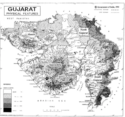
The state of Gujarat encompasses nearly 200,000 km2, a territory that ranges from the Aravalli piedmont to the coast of the Arabian Sea (Gujarat Vishvakosh Trust 2007:6). A review of the physical geography and climate across regions helps provide a clear context for discussions of past human ecologies. Primary focus is on North Gujarat, with particular attention paid to relict sand dunes and why these dunes have been consistently occupied by people since the Mesolithic period 16 (Allchin et al. 1978:249, 257, 326). Relationships between soil, climate and topography result in a region where mobility is the best adaptive strategy.
Historical Geology
During the Lower Cretaceous period, Gujarat was completely covered by the Deccan Trap lava flow. At the end of this period, it was covered by the sea and thus bears nummulitic marine deposits (GSG 1989:36). The majority of landforms (such as the Rann of Kutch) were created in the post-Tertiary period during the uplift of the Himalayas. In 1819, a large earthquake created the Allah Bund fault, and the region remains tectonically active today (as evidenced by the massive 2001 Bhuj earthquake).
There are a number of economically important mineral deposits in this state, particularly agate, which was an important commodity during the Bronze Age. Randall
16
Law’s study (2008:458, 462) demonstrates the importance of the Mardak Bet and Khandek deposits in Kutch as major sources of agate for Mature Harappan sites in the Indus Valley and Gujarat. In addition, kaolinite is found in large deposits along the Sabarmati River in the Sabarkantha district. Smaller deposits of kaolinite are found in the districts of Mehsana, Junagadh and Kutch. Base metals (lead, zinc and copper) are found mainly at Ambaji. Ochre deposits (yellow and red) are found in rock beds and laterite layers in the Jamnagar district, particularly in the Morbi and Wakaner talukas. White quartz is present in large veins, chiefly in the plains (north and south). Steatite is found chiefly in the Sabarkantha district.
Soils
Precipitation
Aside from numerous wells tapping groundwater, the most important water source in this state comes from the summer monsoon (June–August) that washes down from the higher elevations (such as the Aravalli, Girnar and Dharwar ranges) and creates annual rivers and watering holes. The majority of rivers in Gujarat result from this drainage process (see Figure 3.1). Only a few (the Sabarmati, Mahi, Narmada and Tapi) are perennial rivers that do not depend on the monsoon for replenishment (though their discharges increase significantly during the summer; see Allchin et al. 1978:14).
Annual precipitation varies considerably across the state. The southern coastal regions experience up to 2000 mm of rain per year while the semiarid areas receive only 300–400 mm per year (Dikshit 1970:28). It is worth noting that the southeastern part of the state experiences the most rainfall, not just because of its proximity to the ocean, but also because of its location on the windward side of the Dharwars. Rainfall peaks in July during the summer monsoon season and is virtually nonexistent during the dry winter months.
The Regions of Gujarat (See Figure 3.2)
Delineating boundaries
The boundaries that divide these regions are based principally on water features and topography. Saurashtra is the most clearly defined region, as it is a peninsula
separated from the rest of Gujarat on the east by the Gulf of Khambhat and the Sabarmati River and on the north by Kutch. Kutch is defined as a distinct region based on the segregation of the Kutch plateau and associated islands (Khadir and Bela) from other landforms by the Great and Little Ranns. The northern and southern plains of Gujarat are well segregated from the Deccan Plateau to the east by two primary ranges: the southern spurs of the Aravallis and the Dharwars (Dikshit 1970:6). The Gujarat plain is sometimes referred to as “mainland” Gujarat and is split into two subregions by differences in precipitation and soil. South Gujarat has more rainfall and is composed of black cotton soil (Possehl 1980:29). South Gujarat is further distinguished from the north by its large rivers carrying water and silt from the Aravallis and Deccan Plateau. North Gujarat is more arid and contains sandy alluvium. Finally, each of these regions has its own distinct drainage networks that do not articulate with those of other regions (Dikshit 1970:23).
Saurashtra
Kutch
Kutch is the most physically distinct region of Gujarat, as the landmass is virtually an island. The west coast faces the Arabian Sea; the southern and northern coasts are ringed by the Great Rann, a 7000 km2 salt waste that is flooded annually during the summer monsoon (Dikshit 1970:15). Research on the development of this feature suggests that Kutch was at one point an island and that the Great Rann gradually filled in with alluvial silt, thus creating the terrestrial expanse seen today (Allchin et al. 1978:7). The presence of ancient oyster beds, swash marks and fossil beaches higher than 8 m above the present surface indicate that the Great Rann was a permanent shallow bay until relatively recently, and that its current dry state was caused by changing fluvial processes and tectonic shifts (Roy and Merh 1977:199). Some scholars (Rao 1973; Gupta and Pandya 1980) believe that Kutch was an island during the Mesolithic to Early
Historic periods, though Joshi (1977) contends that the Rann was dry enough to cross on foot throughout occupational periods. A current project on the geological history of the Little Rann may demonstrate that this feature held water 2-5m deep between 4000 BC – 0 AD and began to dry out at the beginning of the first millennium AD (Rajaguru and Deo 2010:3).
South Gujarat
The Mahi, Narmada and Tapi rivers are all major drainages originating in central India, and most of the alluvium from these rivers is deposited within the South Gujarat plain. High precipitation, large perennial rivers and rich soils make this a very