Biennial Report to Congress:
PROGRESS MADE IN IMPLEMENTING
THE OCEAN AND COASTAL MAPPING
INTEGRATION ACT: 2009 - 2010
PRODUCT OF THE
Committee on Environment, Natural Resources,
and Sustainability
THIS DOCUMENT IS A PRODUCT OF
THE NATIONAL SCIENCE & TECHNOLOGY COUNCIL’S
COMMITTEE ON ENVIRONMENT, NATURAL RESOURCES, AND SUSTAINABILITY
The National Science and Technology Council (NSTC) is the principal means by which the
Executive Branch coordinates science and technology policy across the diverse entities that make
up the Federal research and development enterprise. A primary objective of the NSTC is
establishing clear national goals for Federal science and technology investments. The NSTC
prepares research and development strategies that are coordinated across Federal agencies to
form investment packages aimed at accomplishing multiple national goals. The work of the
NSTC is organized under five committees: Environment, Natural Resources and Sustainability;
Homeland and National Security; Science, Technology, Engineering, and Math (STEM)
Education; Science; and Technology. Each of these committees oversees subcommittees and
working groups focused on different aspects of science and technology. More information is
available at
http://www.whitehouse.gov/ostp/nstc
.
About the Office of Science and Technology Policy
The Office of Science and Technology Policy (OSTP) was established by the National Science
and Technology Policy, Organization, and Priorities Act of 1976. OSTP’s responsibilities
include advising the President on policy formulation and budget development on questions in
which science and technology are important elements; articulating the President’s science and
technology policy and programs; and fostering strong partnerships among Federal, state, and
local governments, and the scientific communities in industry and academia. The Director of
OSTP also serves as Assistant to the President for Science and Technology and manages the
NSTC. More information is available at
http://www.whitehouse.gov/ostp
.
About the Committee on Environment, Natural Resources, and Sustainability
The purpose of the Committee on Environment, Natural Resources, and Sustainability (CENRS)
is to advise and assist the NSTC, under Executive Order 12881, to increase the overall
productivity and application of Federal research and development (R&D) efforts in the areas of
environment, natural resources, and sustainability. The CENRS provides a formal mechanism for
interagency coordination relevant to environment, natural resource, and sustainability policy and
R&D issues domestically and internationally.
About the Subcommittee on Ocean Science and Technology
The purpose of the Subcommittee on Ocean Science and Technology (SOST) is to advise and
assist the CENRS on national issues of ocean science and technology. The SOST will contribute
to the goals for Federal ocean science and technology, including by developing coordinated
interagency strategies. The SOST works closely with the subcommittee on Oceans Policy of the
Global Environment Policy Coordinating Committee (Oceans Sub-IPC) established by National
Security Presidential Directive-1 and National Security Council Memorandum of May 25, 2001,
with the National Ocean Research Leadership council (NORLC), and its derivative bodies of the
National Oceanographic Partnership Program (NOPP), as established by Public Law 104-201 in
FY 1997, and with the National Ocean Council (NOC), as established by Presidential Executive
Order 13547 on July 19, 2010, and its associated bodies, including its Steering Committee, the
Ocean Research and Resources Advisory Panel (ORRAP), the Governance Coordinating
Committee, and the Ocean research Management interagency Policy Committee (ORM-IPC).
PROGRESS MADE IN IMPLEMENTING
THE OCEAN AND COASTAL MAPPING
INTEGRATION ACT: 2009 - 2010
1
REPORT TO THE COMMITTEE ON COMMERCE, SCIENCE, AND TRANSPORTATION OF
THE SENATE, THE COMMITTEE ON ENERGY AND NATURAL RESOURCES OF THE
SENATE, and THE COMMITTEE ON NATURAL RESOURCES OF THE HOUSE OF
REPRESENTATIVES
Biennial Report to Congress:Progress Made in Implementing the Ocean and Coastal Mapping Integration Act: 2009 - 2010
This report responds to requirements in the Omnibus Public Land Management Act of 2009 (P.L. 111-11), and specifically the Ocean and Coastal Mapping Integration Act (P.L. 111-11, Title XII, Subtitle B). The Ocean and Coastal Mapping Integration Act (hereafter, “Act”) directs the co-chairmen of the Interagency Committee on Ocean and Coastal Mapping to “…transmit to the Congress a report detailing progress made in implementing this subtitle” (see Appendix 1 for the full text of the reporting
requirements as contained in Section 12204 of the Act).
Executive Summary
The Act requires an Interagency Committee on Ocean and Coastal Mapping and coastal states to establish a program to develop a coordinated and comprehensive national ocean and coastal mapping plan for the Great Lakes and coastal-state waters, the territorial sea, the exclusive economic zone, and the continental shelf of the United States. The Interagency Working Group on Ocean and Coastal Mapping (IWG-OCM), under the Subcommittee on Ocean Science and Technology1 (SOST) was charged with performing these duties. SOST serves as the ocean science and technology interagency policy committee of the National Ocean Council and ensures connectivity between IWG-OCM activities and the National Ocean Policy. In accordance with the Act, the IWG-OCM is enhancing its coordination of ocean and coastal mapping to more effectively and efficiently provide stakeholders and the public with
comprehensive geospatial information.
This report, as required by Section 12204 of the Act, describes the diverse Federal ocean and coastal mapping programs and explains IWG-OCM efforts to ensure effective intra- and interagency mapping coordination in the 2009 – 2010 period. The 13 reporting items called for in the Act are identified at the start of each section. Due in part to one-time funding through the American Recovery and
Reinvestment Act, agencies have made progress in supporting efficient acquisition, management, and dissemination of data; improving mapping technologies; and pursuing other efforts to improve our Nation’s ability to meet its ocean and coastal mandates.
1 With President Obama’s July 19, 2010, Executive Order 13547 adopting the recommendations of the Interagency
Ocean Policy Task Force, under the new ocean policy structure, the SOST serves as the Ocean Science and Technology Interagency Policy Committee (OST-IPC) under the National Ocean Council.
2
Contents
Executive Summary ... 1
Act Requirements, Sec. 12204………..………4
Introduction ... 5
Inventory Ocean and Coastal Mapping Data ... 6
Identification of Priority Survey Areas ... 9
Navigation, transportation and security ... 10
Climate change and hazard resiliency ... 11
Ecosystem-based management ... 11
Energy siting and resource extraction ... 13
Integrated Mapping Resources and Requirements ... 14
Integrated Mapping Projects and Results ... 17
Gulf of Mexico Alliance ... 18
California Seafloor Mapping ... 18
Massachusetts Mapping Partnership ... 19
Post-hurricane elevation mapping ... 20
Multipurpose Marine Cadastre ... 20
National Land Cover mapping ... 20
ARRA funded efforts ... 21
Data and Documentation Requirements ... 21
Data standards ... 22
Metadata standards ... 23
New approaches to ocean mapping data processing ... 23
Ensuring the preservation of data ... 24
Status of Current OCM Activities ... 24
Integrated digital maps ... 24
Leveraging resources and improving coordination ... 25
Declassifying OCM data ... 28
Digital Coast Integrated Mapping Pilot ... 29
Digital Coast Northern Gulf of Mexico pilot resource plan ... 29
Federal Contracting Policies ... 30
Contracting with non-governmental entities ... 30
Plan Forward ... 33
Conclusion ... 34
3 Appendix 2: List of Acronyms ... 36
4
Act Requirements, Sec. 12204
Page
(1) an inventory of ocean and coastal mapping data within
the territorial sea and the exclusive economic zone and throughout the Continental Shelf of the United States, noting the
age and source of the survey and the spatial resolution (metadata) of the data;
6
(2) identification of priority areas in need of survey coverage
using present technologies; 9
(3) a resource plan that identifies when priority areas in need of modern ocean and coastal mapping surveys can
be accomplished; 14
(4) the status of efforts to produce integrated digital maps
of ocean and coastal areas; 24
(5) a description of any products resulting from coordinated
mapping efforts under this subtitle that improve public understanding of the coasts and oceans, or regulatory decision making;
17
(6) documentation of minimum and desired standards for
data acquisition and integrated metadata; 21 (7) a statement of the status of federal efforts to leverage
mapping technologies, coordinate mapping activities, share
expertise, and exchange data; 24
(8) a statement of resource requirements for organizations to meet the goals of the program, including technology needs
for data acquisition, processing, and distribution systems; 14 (9) a statement of the status of efforts to declassify data
gathered by the Navy, the National Geospatial-Intelligence
Agency, and other agencies to the extent possible without jeopardizing national security, and make it available to partner
agencies and the public;
24
(10) a resource plan for a digital coast integrated mapping pilot project for the northern Gulf of Mexico that will—
(A) cover the area from the authorized coastal counties through the territorial sea;
(B) identify how such a pilot project will leverage public and private mapping data and resources, such as the United States Geological Survey National Map, to result in an operational coastal change assessment program for the subregion;
29
(11) the status of efforts to coordinate federal programs
with coastal state and local government programs and leverage
those programs; 24
(12) a description of efforts of federal agencies to increase
contracting with nongovernmental entities; and 30 (13) an inventory and description of any new federal or
federally funded programs conducting shoreline delineation and ocean or coastal mapping since the previous reporting cycle.
N/A due to
first report
5
Introduction
This report is being submitted in compliance with Section 12204 of the Act, requiring a report on progress in implementing the Act, with emphasis on 13 enumerated subjects. The subjects in Section 12204 are addressed the subsections of this report.
As defined in the Act, ocean and coastal mapping is the acquisition, processing, and management of physical, biological, geological, chemical, and archeological characteristics and boundaries of ocean and coastal areas, resources, and sea beds using a variety of mapping technologies. These data constitute the essential foundation for understanding and managing our coastal and ocean areas. The Interagency Working Group on Ocean and Coastal Mapping (IWG-OCM) is charged with collaborating with Federal and state mapping agencies to implement the practice of coordinated planning, acquisition,
management, integration, and dissemination of Federal ocean and coastal mapping (OCM) data and derivative products in a manner that permits easy access to and use by the greatest range of consumers. The IWG-OCM strives to adopt these practices throughout Federal mapping programs with the
philosophy of “map once, use many times.” Successful implementation of the Act will improve Federal, state, and local government abilities to establish research and mapping priorities, advance ocean science, and advance coastal and marine spatial planning (marine planning) to sustain economic, ecological, and cultural resources for future generations.
6 Agencies tasked with
collecting, archiving, assimilating, and
disseminating data need to increase their cooperation and coordination and provide faster, easier, and more unified access to raw and processed data. In return, scientists and other data generators need to feed valuable, high quality data into the national system in a timely way. -- An Ocean Blueprint for the 21st Century
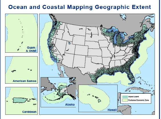
In general, the ocean and coastal zone includes inland estuarine and coastal drainage areas and extends seaward to include the 200 nautical mile exclusive economic zone (EEZ) for the Nation (see Figure 1) and the continental shelf (the extent of the U.S. continental shelf, as defined by the Law of Sea, is not depicted in Figure 1). This area will expand seaward to the limits of the U.S. Extended Continental Shelf (ECS), once the limithas been established.
Inventory Ocean and Coastal Mapping Data
Certain mapping data are essential to support research, management, and planning efforts in the ocean and coastal zone. In November 2009, the IWG-OCM held a workshop to address the development of a National Mapping Plan, including the identification of critical framework data layers. These framework data include elevation – below and above the water – (bathymetry and coastal topography); imagery data describing surface characteristics such as land cover, built areas, and seafloor habitat; and geophysical data, such as seismic and shoreline data, describing the surface and subsurface of the seafloor. Workshop participants noted that geodetic control and cadastre information are also critical to support all ocean and coastal mapping efforts. The IWG-COM is focusing initially on these framework data, but will expand efforts to include other OCM data defined in the Act. While many agencies collect and distribute OCM data and derived products in support of national missions (see Table 1), there are a limited number of major Federal and academic repositories holding these public framework data. These repositories serve as stewards of public data, maintain descriptions of these data, and distribute data and derived products to a variety of users.
Federal ocean and coastal mapping agencies are developing an integrated and publically-accessible national inventory. This
inventory will combine continually updated web services, developed and maintained by primary federal data repositories, utilizing common terminology. The resulting national inventory service will outline the geographic coverage for repository data and provide metadata (e.g., type of observation, date and method of collection, location) to obtain further information and download the data. One key characteristic of the integrated service is that it will dynamically reflect changes in the repositories as they occur. Another is that it will be standards-based to be sustainable and adapt to changes in technology. Figure 2 shows an example from an initial draft inventory containing bathymetric data from Federal and academic repositories.
Ocean and Coastal Mapping Integration Act:
(1) an inventory of ocean and coastal mapping data within the territorial sea and the exclusive economic zone and throughout the Continental Shelf of the United States, noting the age and source of
7 Table 1: Summary of major ocean and coastal mapping framework data collections by agency/program
Agency/Program Framework
Data Collected
Mission Support Public
Availability National Oceanic and Atmospheric Administration (NOAA) Elevation (bathymetry and topography), imagery, geophysical (seismic and shoreline)
Nautical charting, hydrographic and geospatial services for marine commerce; stewardship and protection of trust resources; protection and restoration of critical OCM habitats; observation and monitoring; mitigation of coastal hazards; research; delivery of and decision-maker access to relevant science, tools, products, and services
Data are publicly available within 3-18 months of collection
U.S. Army Corps of Engineers (USACE) Elevation (topography, bathymetry and navigation channel data), imagery
Operation and maintenance of coastal navigation and flood protection projects; regional sediment management; environmental protection, restoration, and stewardship; disaster preparation and response; and regulatory oversight
Data are publicly available within 3-12 months of collection Bureau of Ocean Energy Management, Regulation, and Enforcement (BOEMRE) Elevation (bathymetry), geophysical (seismic)
To determine the environmental and production feasibility of leasing seafloor, the resource potential of the Outer Continental Shelf areas, and the fair market value of individual lease blocks prior to sale
Proprietary data public after 25 years U.S. Geological Survey (USGS) Elevation (topography, bathymetry), imagery, geophysical (seismic)
National Map maintenance, geologic characterization of public lands, including submerged lands, scientific research and monitoring of earth processes to hazards assessments and the provision of interpretive maps of land cover, geology, and submerged habitats
Most underwater data are publically available within 3-18 months of collection Academia Rolling-deck to Repository (R2R) Elevation (bathymetry, topography), imagery, geophysical (seismic)
To support scientific research Data are publicly available in 12-14 months, metadata in 6 months Federal Emergency Management Agency (FEMA) Elevation (topography)
To support the National Flood Insurance Program and FEMA Mitigation programs
Most data are available 1-3 years from date of collection
Navy Elevation
(bathymetry)
To support national security As much data as possible is made publicly available
8 Web map discovery of existing data is only one piece of the puzzle to enable planning, improve access, and ensure understanding of OCM data. In 2007, the IWG-OCM held a workshop to recommend an approach for creating a national inventory of planned, ongoing, and completed OCM field activities and a clearinghouse for OCM data. The workshop recommended Geospatial One-Stop (GOS), a geoportal created by the Federal Geographic Data Committee (FGDC) to provide public access to geospatial information as part of a U.S. e-government initiative. Metadata for OCM data is already included in GOS; planned field activities can be published to the GOS Marketplace, a section of the GOS metadata repository that connects data acquisition activity planners to each other and to those with unmet acquisition requirements. The OCM Inventory project provided encouragement and assistance to OCM organizations in publishing metadata to GOS. In the past three years, IWG-OCM members published over 25,000 new ocean and coastal metadata records to GOS in support of the OCM Inventory, including information about planned, completed, and desired federal data acquisition activities and the resulting datasets. GOS includes information from state and local governments; academic and private
organizations; and individuals. The inventory of existing data based on dynamic web services of the primary Federal framework data repositories will be integrated into GOS. Integrating inventories of existing data with those of planned and desired surveys are essential for identifying data gaps that could lead to potential partners for cooperative projects in both the mapping and marine planning fields. Since implementing marine planning requires basic spatial data such as bathymetry and elevation to create the geographic information system (GIS) framework layers, identifying these data gaps will alert planners to areas where data is needed, and provide partnering opportunities in to acquire data to satisfy multiple data requirements.
All geospatial data - including OCM data - are referenced to locations on the Earth’s surface through a defined coordinate system. Geodetic surveys and data enable establishment of a consistent national
9 coordinate system - the National Spatial Reference System (NSRS) - that serves as the foundation for subsequent surveying, mapping, and charting in the U.S. and its territories. This consistent system of geodetic control (latitude, longitude, height, water level, scale, gravity, and orientation) throughout the Nation enables accurate registration of geospatial data collected with a variety of technologies, and extends across large areas and time scales.
In addition to the framework data, the OCM Inventory includes diverse data such as horizontal and vertical geodetic control data, water level measurements, and physical data supporting ecosystems-based management and the integration of data collected on- and off-shore. Metadata for each survey or dataset contain the basic information on the type, age, source, and acquisition to enable users to both assess the utility of data and access the data.
A priority during the next two years will be to identify, develop, and encourage the use of tools and vocabularies for metadata and standards-based web services that will make OCM data more readily discoverable and reusable. The primary Federal repositories will work together to adopt common methods and descriptions and to serve inventories of their data holdings through appropriate web services. These efforts will be coordinated with the development of a national information
management system dedicated to coastal and marine scientific data to meet data needs for marine planning.
Identification of Priority Survey Areas
With intra- and interagency planning and coordination, overlapping agency mission requirements can be better integrated, prioritized, and managed to maximize the return on Federal investments in ocean and coastal mapping. Many Federal, state and private-sector customers rely on coastal, seafloor, and water column mapping data, and demand for these data is growing. The IWG-OCM supports intra- and interagency coordination by sponsoring workshops and meetings, and encouraging development of tools to sustain integrated planning. While the IWG-OCM has made progress, a suitably resourced program will enable coordinated planning, acquisition, processing, and delivery of integrated data and products and result in long-term cost savings with leveraged resources and multi-purposed data. Ocean and coastal mapping framework data support the mapping applications required for marine planning to meet the Nation’s economic, and natural-resource preservation and management needs. For the purposes of this section, these mapping applications have been grouped into the following four, broad categories: (1) navigation, transportation, and security; (2) climate change and hazard resilience; (3) ecosystem-based management; and (4) energy siting and resource extraction. Each category requires different mapping standards, needs, and priorities. Federal agencies have historically established
individual mapping priorities and data acquisition plans based in large part on their specific mandates, Ocean and Coastal Mapping Integration Act:
10 With over 95,000 miles of coastline and the largest Exclusive Economic Zone in the world, our Nation benefits from a wealth of goods and services derived from the ocean, our coasts, and the Great Lakes. Final Recommendations of the Interagency Ocean Policy Task Force, July 19, 2010
responsibilities, available technologies, and resource levels. Within each category, the identification of priority survey areas, and the technologies required to survey these areas, will be driven by factors based on the broad mapping application of that category. The descriptions below and in Table 2 summarize the requirements according to OCM framework data and to “zones” defined as:
Coastal Zone (shoreline to inland Ocean and Coastal Mapping boundary)
Nearshore Zone (shoreline to 10 meters depth within State waters and territorial seas) State waters and territorial sea, includes the Great Lakes (10 meter depth out to 12 miles) EEZ and U.S. continental shelf as defined by the Law of the Sea treaty (12 miles to 200 miles
and beyond)
These "zones" are somewhat imprecise and represent an operational definition that reflects (1) survey tools and capabilities required and (2) distinctions in user/stakeholder communities and their
requirements across these zones. The terminology does not match any established legal zones or boundaries and is intended to categorize mapping needs and activities in a way that supports
assessments of needs and gaps and enables the success of coordinated efforts to increase availability of data and products.
Navigation, transportation, and security
The U.S. Marine Transportation System moves over 95% of the volume of U.S. overseas trade. Current OCM data are essential to support this system. Several federal agencies are responsible for surveying and mapping U.S. waters to ensure the safety of navigation and transportation, as well as providing for the security of the nation. This includes the production and maintenance of the U.S. suite of print, raster, and electronic navigational charts and maps; the development and maintenance of the nation’s federal commercial waterways; maintenance of the national network of fixed and floating navigational aids supporting commercial and recreational maritime traffic; and global maritime geospatial
intelligence in support of national objectives.
Modern technologies used for surveys in support of navigation, transportation, and security are designed to determine accurate elevations (e.g., building heights and shoal depths), detect hazards (such as terrestrial towers and underwater obstructions), and provide high resolution imagery for surface classification. These technologies include airborne lidar (Light Detection And Ranging), waterborne multibeam echosounder, side scan sonar, and satellite or
airborne synthetic aperture radar and imagery.
Priority areas in need of modern surveys include access routes of the highest commercial and military value, including major shipping
waterways, channels, and ports. These priority survey areas are located primarily along the coasts and within the State waters and territorial seas zone. An emerging priority area is the Arctic. As a result of climate change and other factors, Arctic sea ice is retreating at an unprecedented rate. Reduced sea ice creates opportunities for trans-Arctic shipping;
11 increased oil and gas exploration and extraction; tourism; and other uses that increase regional
commercial and military vessel traffic.
While priority navigation channels are maintained on surveys collected at least annually, the Arctic is severely deficient in many of the marine transportation services that the Federal government extends to the rest of the Nation. The region has virtually no geospatial infrastructure for accurate positioning and elevations; sparse tide, current, and water-level observations and prediction coverage; obsolete shoreline and hydrographic data; and poor nautical charts. Most charted Arctic waters were surveyed with obsolete technology, some dating back to the 1800s. Most of the shoreline along Alaska’s northern and western coasts has not been mapped since 1960, and confidence in the nautical charts is extremely low. As a matter of priority, the Federal government has developed a multi-year survey plan to address the navigationally critical survey requirements for nautical charting in the Arctic.
Climate change and hazard resilience
Future climate-change-related impacts may include increased global temperatures; melting sea ice and glaciers; increased frequency of extreme weather events; lower lake levels; and rising sea levels that are expected to amplify the effects of other coastal hazards. The interdependence of ecosystems and economies makes coastal and Great Lakes communities increasingly vulnerable to natural and human-induced hazard impacts, including oil spills, harmful algal blooms, climate change, and severe weather risks. With 53% of the Nation’s population residing in coastal areas and 57% of the U.S. gross domestic product produced in coastal areas, the need for OCM data to enable communities to plan for, recover from, and adapt to natural and man-made hazards is acute. The Gulf of Mexico Alliance is one example of an integrated regional effort that holistically addresses the impacts of climate change and improves coastal hazard resilience (see description on page 16).
Priority mapping areas include the coastal and nearshore zones, State waters and territorial seas, and EEZ and U.S. continental shelf. Primary OCM data essential to support climate change and hazard resilience are topography and bathymetry (including nearshore data collected with lidar), side scan and multibeam sonar, imagery, and high-resolution seismic and other geophysical data. Other required OCM data include sediment coring and high-resolution satellite imagery (optical, land cover, and radar). Acquiring these data is the first step to assess the response and vulnerability of coastal systems to future natural and anthropogenic changes.
Ecosystem-based management
An ecosystem is a geographically-specified system of organisms (including humans), the environment, and the processes that control its dynamics. To more effectively assess the health of our ocean and coastal environment and determine the best way to maintain it, the ecosystem - its processes, its organisms, and its functions - must be taken into account. Marine, coastal, and riverine habitats are under increasing pressure from climate change, ocean acidification, unsustainable fishing practices, human population growth, onshore and offshore development, and extreme events like storms and oil spills. Ecosystem-based management integrates ecological goals with social, economic, commerce, health, and security goals, and recognizes humans as key components of the ecosystem and healthy ecosystems as essential to human well-being. Addressing the many regulatory and legal requirements
12 at all levels of government for environmental and resource management requires scientific
understanding of the ecosystem processes. For example, Essential Fish Habitat and Habitat Areas of Particular Concern are designated as part of the fishery management process, and Critical Habitat is designated for species listed under the Endangered Species Act. These laws require periodic updates to develop and refine conservation and management programs. Many of these habitats are poorly mapped, which can lead to unnecessarily restrictive and outdated regulations intended to provide a precautionary buffer in the face of scientific uncertainty.
Mapping and characterization of the linkages among habitats, organisms, and ecosystems are key components of this scientific understanding and require bathymetric, topographic, geophysical, and imagery data framework. Because of the wide array of legal mandates and the magnitude of the data gaps, substantial needs for habitat mapping and characterization exist in all of the OCM zones. Priorities, data types, and applicable technologies differ regionally. Bathymetry and backscatter from multibeam and side scan sonar and other remote sensing technologies are often used for mapping, and can be combined with in situ sampling or observations for ground-truthing and biological sampling to
characterize habitats. Requirements also differ in terms of temporal and spatial resolution. Often, high resolution information to support detailed, site-specific research and process studies can be
complemented by regional mapping at lower resolution to extrapolate site-specific results. Within the coastal zone, key habitats include marshes and other wetlands; submerged aquatic
vegetation; living substrates, such as oyster reefs; and hard and soft bottoms. Priority survey areas for the nearshore and territorial sea include tropical and sub-tropical coral reefs and hard bottoms in all regions. Within the EEZ and U.S. continental shelf, priority areas include shelf and slope habitats such as banks and canyons (supporting many important fishery stocks), the untrawlable habitat over rough bottoms, and deep coral (required to be mapped by the Magnuson-Stevens Fishery Conservation and Management Reauthorization Act).
13 Energy siting and resource extraction
Coastal regions increasingly face competing management uses of ocean and coastal resources. Decision-makers require access to the relevant science, tools, products, and services to assess the impact of decisions within a science-based framework. As defined in the Final Recommendations of the Interagency Ocean Policy Task Force, marine planning is “a comprehensive, adaptive, integrated, ecosystem based, and transparent spatial planning process, based on sound science, for analyzing current and anticipated uses of ocean, coastal, and Great Lakes areas.” Marine planning “identifies areas most suitable for various types or classes of activities in order to reduce conflicts among uses, reduce environmental impacts, facilitate compatible uses, and preserve critical ecosystem services to meet economic, environmental, security, and social objectives.“ Marine planning is one tool increasingly used to manage energy siting and resource extraction in the ocean and coastal zone. OCM data comprise the framework enabling marine planning.
Within the energy siting and resource extraction category, the primary OCM data required are bathymetry and seafloor imagery (typically seismic and side scan sonar), and waves and currents data seaward of the Submerged Lands Act (SLA) boundary. Federal regulation relies primarily on proprietary data collected by industry to assess resources. The types of energy and resource uses regulated, permitted, and leased on such Outer Continental Shelf (OCS) lands include sand and gravel for shoreline replenishment, oil and gas development, and renewable wind and hydrokinetic development. Oil, gas and hydrokinetic development may occur at almost any depth, while sand, gravel and wind power development currently rely on relatively shallow areas. Sand and gravel resources are typically determined through high resolution (high frequency, shallow penetration) 2-dimensional (2D) seismic surveys, which are also utilized for almost all renewable energy projects. 3-dimensional (3D) seismic surveys penetrate deep into the seabed revealing the underlying structure, providing useful information for a variety of resource, construction, and hazard research efforts. In addition to the needs for seismic data, bathymetric data are essential for all energy siting and resource extraction applications.
While the Bureau of Ocean Energy Management, Regulation, and Enforcement (BOEMRE) relies
primarily on industry or state/Federal partners who acquire seismic and bathymetric survey data, there are funds available for acquisition and analysis of existing datasets. As a condition of the permits, however, survey data provided by the oil and gas industry is proprietary for 25 years before public release (except with permission of an individual permittee).
14 Table 2: Summary of priority mapping requirements by category
Navigation,
transportation,
security
Climate change
and hazard
resiliency
Ecosystem-based
management
Energy siting
and resource
extraction
Zone Primarily Coastal Zone,
Nearshore Zone, and within the State water and territorial sea, but also extending into the EEZ
Coastal Zone,
Nearshore Zone, State waters and territorial sea, and EEZ
Coastal Zone, Nearshore Zone, State waters and territorial seas, and EEZ
On the continental shelf, seaward of the Submerged Lands Act boundary
OCM Framework Data Elevation (bathymetry, topography), imagery (aerial) Elevation (bathymetry, topography, imagery (aerial), geophysical data Elevation (bathymetry, topography) Elevation (bathymetry), geophysical (seismic) Other OCM Data
Imagery (satellite and radar), bottom samples, geodetic control, water level
Sediment coring, vibracores, high-resolution satellite imagery (optical, land cover, and radar)
In-situ and biological sampling, ocean color, temperature, and surface winds Water level, currents, and environmental
Use Determine accurate distances, detect hazardous obstructions, surface classification, calculate dredging volumes, quantify erosion and accretion
Assess the response and vulnerability of coastal systems to natural and anthropogenic changes Address legal mandates, assessments, identification of resources at risk from hazardous material release Study, assess, regulate, permit and lease OCS lands for shoreline
replenishment, resource development
Integrated Mapping Resources and Requirements
Federal agencies have historically planned and conducted ocean and coastal mapping activities based on specific requirements, mandates, and available funding. Recognizing the need to improve coordination, the IWG-OCM is attempting to identify mapping requirements and resources across the Federal
government. This task is in the beginning stages and will mature as the integrated OCM is resourced and plans can be synthesized.
The foundation of the U.S. maritime economy is the Marine Transportation System (MTS) and the Nation’s nautical charts and related hydrographic information produced and maintained by the Federal government. Actions to maintain the MTS include shoreline delineation, dredging operations, regional
Ocean and Coastal Mapping Integration Act:
(3) a resource plan that identifies when priority areas in need of modern ocean and coastal mapping surveys can be accomplished;
(8) a statement of resource requirements for organizations to meet the goals of the program, including technology needs for data acquisition, processing, and distribution systems;
15 sediment management activities, water level and currents information. The Nation’s MTS survey
requirements are reprioritized periodically to address the dynamic trends in waterborne commerce and the ability to produce more detailed hydrographic survey coverage utilizing modern technologies. Maintaining accurate nautical charts of ever-changing shorelines and seafloors within a reasonable timeframe requires resurveying navigationally significant seafloor areas every 50 years and open shoreline areas every 10 years. Current resource levels support approximately 33% completion of both the seafloor and shoreline survey goals. Shoreline data generated for the purpose of nautical charting constitute the National Shoreline. NOAA reviews survey priorities in the National Hydrographic Survey Plan and publishes new editions annually. Hydrographic surveys for priority federally authorized navigation channels are collected at least annually and before and after dredging operations. To improve management, regional surveys are planned every 2 years to better depict regional sediment transport and develop an understanding of impacts to navigation channel shoaling.
Other OCM requirements, including climate change, hazard resilience, and habitat mapping frequently rely on navigation mapping resources or surveys of opportunity. Habitat mapping and characterization within the agencies responsible for managing living resources frequently occur through partnerships with other agencies or programs requiring OCM information or with academic and private-sector partners that possess the complementary skills and technical assets. Development of a sustained mapping program and plan is hampered by intermittent funding and differing partner priorities. Costs differ widely, depending on the scale and habitat types being mapped. Mapping is only one component of the costs of habitat characterization. Additional field work may be required for biological sampling, ground-truthing of acoustic maps, and for generating and distributing specific products, such as digital maps in a geographic information system (GIS). Table 3 describes ocean and coastal mapping resources and requirements by individual federal mapping agencies.
Table 3: Federal Ocean and Coastal Mapping Data Acquisition – Resources and Requirements
Agency
Mapping
Category*
Goal
Data
acquired
Goal
acquisition
Actual
capability
Average
cost
BOEMRE Energy siting and resource extractionBOEMRE does not have a mapping plan. Most seismic or bathymetric data is obtained from industry and is dependent on interest in particular areas that may be available for future resource development.
2-D seismic $1/LM, 3-D $27-$43 / block FEMA Climate change and hazard resiliency
Provide updated coastal flood hazard data for the National Flood Insurance Plan
Lidar, where not already available from other sources $20M in FY10 TBD $20M in FY10 NOAA Navigation, transportatio n and security
Re-survey hydrographic areas every 50 years and open shoreline every 10 years
Hydrography: Acoustic & lidar Shoreline: Photography 10,000 SNM per year 95,000 LM per year 3,000 SNM per year 3,100 LM per year $18K/ Square Nautical Mile $2.7K/ Linear Mile
16
Climate change, hazard resiliency
Elevation data at 10-meter horizontal / 10-centimeter vertical resolution for high hazard / change areas.
Hydrography, shoreline, and lidar in coordination with other programs Complete initial products of priority areas, with focus on Alaska None identified, partner with other programs for OCM data Ecosystem-based management To consistently / comprehensively map distribution of benthic habitats; cultural resources
Multibeam Echosounder, side scan sonar, ground truth species surveys
OCM varies widely by region and FY, goal is to map coastal US with 15 meter data 2 or more surveys / year plus coordination with partner programs $400K – $1.2M / year NPS Climate change and hazard resiliency
Map coastal bathymetry, topography and geologic framework Acoustic, lidar, satellite imagery Accomplished through interagency partnerships; long-term plan does not exist
Limited to interagency partnerships $100K / year Ecosystem-based management
Map submerged habitats and associated natural and cultural resources Acoustic, lidar, satellite imagery Accomplished through interagency partnerships; long-term plan does not exist
Limited to interagency partnerships $250K / year USACE Resources and Requirements span all mapping categories
Provide regional scale data to support operations,
maintenance, regulatory, construction, environmental, and emergency management activities in the coastal zone every 2 years lidar, topographic lidar, aerial photography and hyperspectral imagery 5,000 LM per year 2,000 LM per year $2.5K / LM USGS Resources and Requirements span all mapping categories
Collect a wide array of data types to meet diverse DOI agencies requirements for geospatial information keyed to 1) agency science mission needs, 2) agency natural resource management mission needs, and 3) a diverse set of partnering opportunities Acoustic, seismic, topographic lidar, bathymetric lidar, aerial imagery, satellite imagery USGS programs maintain and continually update mapping acquisition plans Varies greatly by mission need and survey technology
* The mapping categories defined on page 8 are (1) navigation, transportation and security, (2) climate change and hazard resilience, (3) ecosystem-based management, and 4) energy siting and resource extraction.
Additional resource requirements exist across all OCM agencies. Ocean and coastal mapping
technologies continue to evolve, enabling acquisition of more high-resolution data describing the coast, seafloor, and water column. One of the primary challenges is the shortage of trained personnel to support data acquisition and processing, particularly in programs other than nautical charting and hydrography. New state-of-the-art multibeam mapping systems require that operators be trained in survey planning, at-sea data acquisition and processing practices, as well as post-processing techniques in order to fully realize the maximum benefits from these systems. Training in consistent data
acquisition, processing, and data/metadata management practices is critical in order to utilize and generate useful and reliable products.
17 Technological advances in autonomous and unmanned
vehicles have the potential to revolutionize the collection of the nation’s mapping data. While still under development, these vehicles could, for some mapping and assessment activities, greatly increase mapping data acquisition efficiencies by orders of magnitude through extended on-site operational times and minimal personnel requirements. These
technologies can map areas difficult to survey with traditional methods, including near-shore coastal areas and intertidal zones. These zones are critical for developing accurate tsunami, storm surge, flood plain, circulation, and sediment transport models for hazard planning/resiliency and sea-level-rise mitigation. Technological advances and improved efficiency and collaboration will address some of the nation’s unmet mapping needs; however, the need for basic data collection far exceeds that which can be accomplished using savings associated with greater operational
coordination and more efficient processing, interpretation, and distribution of collected information. In order for Federal mapping programs to meet present and future mandates, the need for basic mapping, coordination, and infrastructure resources must be addressed. The plans to be developed by the National Ocean Council provide one option for addressing these needs, as one of the National Priority Objectives stated in the final report of the Interagency Ocean Policy Task Force deals with mapping (“Ocean, Coastal, and Great Lakes Observations, Mapping, and Infrastructure”).
Integrated Mapping Projects and Results
There are many excellent examples of ocean and coastal maps produced through interagency
coordination. These models demonstrate the advantages of coordination and it is therefore envisioned that the lessons learned will become common practice across the mapping community. Successful projects detailed in this section include the Gulf of Mexico Alliance’s Master Mapping Plan, California and Massachusetts Seafloor Mapping projects, post-storm elevation mapping in the northern Gulf of Mexico, land cover mapping, and America Recovery and Reinvestment Act (ARRA) funded coastal mapping projects. While project specific efforts vary, making products and data available to the public
Ocean and Coastal Mapping Integration Act:
(5) a description of any products resulting from coordinated mapping efforts under this subtitle that improve public understanding of the coasts and oceans, or regulatory decision making;
The ocean, our coasts, and the Great Lakes deeply impact the lives of all Americans, whether we live and work in the country’s heartland or along its shores. America’s rich and productive coastal regions and waters support tens of millions of jobs and contribute trillions of dollars to the national economy each year. They also host a growing number of important activities, including recreation, science, commerce, transportation, energy development, and national security and they provide a wealth of natural resources and
ecological benefits [Final
Recommendations of the Interagency Ocean Policy Task Force, July 19, 2010, The White House Council on
18 and regulators will help improve public understanding of the oceans and coasts as well as play a role in regulatory decision making.
Gulf of Mexico Alliance
The Gulf of Mexico Alliance (Alliance) was formalized by an agreement among the Gulf state Governors to identify opportunities to enhance the ecological and economic health of the Gulf of Mexico (GOM) Region. To support the Alliance’s efforts to address priority coastal and ocean issues and integrate federal efforts, representatives from 13 Federal agencies formed the Gulf of Mexico Regional Partnership Federal Workgroup. Key issues facing the region include the increased threat due to hurricane activity, contaminant risk from off-shore exploration, dramatic landscape change resulting in reduced regional hurricane protection, and the impacts of increased human populations on coastal wetlands and barrier islands. Many Alliance priorities require robust mapping solutions, so Federal workgroup, state, and local Alliance partners have undertaken several efforts to integrate mapping activities, data, and map products for decision makers. The Alliance Governors' Action Plan for Healthy and Resilient Coasts focused on the inventory and integration of habitat, topographic, and bathymetric data for the Gulf of Mexico. These datasets were assimilated in online decision-support tools that utilized standard communication protocols to pull data from databases at different agencies into a single mapping portal. The Alliance Governors' Action Plan II continues these efforts and adds a
comprehensive Gulf of Mexico Master Mapping Plan (GMMMP) that will provide a coordinated approach for the acquisition of physical and environmental datasets to support the activities of all the Alliance priority issue teams. The GMMMP team has identified requirements for mapping in the Gulf of Mexico and is currently identifying mapping activities planned in the Gulf over the next 10 years, both leveraging activities of the IWG-OCM. Ultimately, the GMMMP will facilitate collaboration among federal, state, local, and academic mapping partners in the Gulf to ensure that all mapping requirements of Gulf stakeholders are met in a timely and cost-effective manner. In the wake of the Deepwater Horizon oil spill, the partnerships forged through Alliance activities in general and mapping activities in particular have served the region well and will continue to do so throughout the recovery and
restoration phases of the disaster. These efforts will support the strategy developed by the Gulf Coast Ecosystem Restoration Task Force.
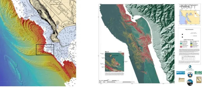
California Seafloor Mapping
The California Seafloor Mapping Project (CSMP) is a multi-agency partnership between the State of California, Federal mapping agencies, and the private-sector to develop the first comprehensive and seamless maps of California’s seafloor and marine resources. CSMP is overseen by the California Coastal Conservancy in partnership with the California State University at Monterey Bay, Moss Landing Marine Laboratory, and the California Geological Survey. The Federal Government - using private-sector
hydrographic services contracts - acquired, processed, and archived high-resolution bathymetry and acoustic backscatter data along with near-shore bathymetric and topographic lidar data that will facilitate
Figure 4: Geomorphology of the mouth of San Francisco Bay, CSMP
19 the development of seamless coastal digital elevation models (see Figure 4). The data are ground-truthed and developed into geologic and habitat base maps.
The data acquired and products developed are enhancing efforts to manage marine ecosystems and coastal resources, identify obstructions to navigation, and better understand the California coast’s natural hazards. The data and products will be used to update nautical charts along the California coast, support the designation and monitoring of marine reserves and marine protected areas, manage marine fisheries, regulate coastal development, improve the understanding of sediment transport and coastal erosion, improve coastal circulation models, improve assessments of earthquake and tsunami hazards, and help prepare for sea-level rise impacts. This integrated ocean and coastal mapping effort has provided approximately 7,550 square kilometers (2,200 square nautical miles) of high-resolution multibeam bathymetric data along California’s coast out to three nautical miles. The 2006 West Coast Governors’ Agreement (WCGA) on Ocean Health, which launched a new, proactive regional
collaborative effort to protect and manage the ocean and coastal resources along the entire West Coast, has benefited directly from this effort. Marine planning is a valuable initiative in support of this
agreement. Survey and other geospatial activities in support of the WCGA and the federal government’s diverse ocean and coastal mapping have been extended north into Oregon state waters.
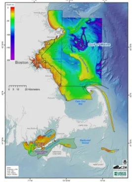
Massachusetts Mapping Partnership
The Massachusetts Office of Coastal Zone Management, working with the Federal Government, initiated the Seafloor Mapping Cooperative in 2003 to address the need to acquire datasets on the spatial
distribution of benthic habitats to help resource management. The goal is to comprehensively map the topography and geology of the seafloor in Massachusetts (see Figure 5). By June 2008, the seafloor environment was mapped from the New Hampshire border to
Cape Cod Bay. Regional, high-resolution geologic mapping of the seafloor environment is accomplished using side scan sonar, interferometric sonar (bathymetry), and sub-bottom profiling, resulting in contiguous and detailed geospatial data and maps of surficial sediment distribution (backscatter intensity and
interpretation), seabed topography (bathymetry), and underlying geology (seismic reflection). Sediment samples, underwater video, and bottom photographs are collected to verify that changes in sonar backscatter reflect variations in sediment distribution (i.e., silt vs. sand vs. gravel vs.
rock/bedrock). The resulting products of the partnership are regional reports that include maps of shaded-relief seafloor topography and acoustic backscatter intensity, along with interpretative geologic maps, a catalog of data and imagery, and a geospatial database that can be accessed and managed via geographic information system (GIS) software. The reports contain detailed descriptions of the data collection, processing, and accuracy assessment, as well as the analysis procedures and
Figure 5: Bathymetry for regions mapped by the Massachusetts Mapping Partnership
20 GIS data layers used to create the interpretative maps. All GIS data have Federal Geographic Data Committee FGDC compliant metadata.
Post-hurricane elevation mapping
An example of excellent interagency mapping coordination is the collaboration of Federal agency coastal programs in which all post-Katrina and post-Rita lidar data are being assembled into a seamless 1/9-arc-second (3-meter) elevation dataset. This topographic dataset includes lidar data collected by federal, state, and local government entities in the Gulf Coast region. These data, along with the existing 1/9-arc-second elevation dataset developed from pre-Katrina lidar collections, will be useful for characterizing vegetative, hydrologic, and geomorphic changes to the landscape resulting from the hurricanes. The data integration and mapping techniques being applied in the coordinated construction of a
topographic/bathymetric map of the Gulf of Mexico region were previously developed and refined for Tampa Bay, North Carolina, Delaware Bay, San Francisco Bay, and Puget Sound. The recently completed vertical datum transformation tool (VDatum) for the northern Gulf Coast is essential to produce a high quality, seamless dataset. (VDatum is a new software tool designed to transform geospatial data between a variety of vertical tidal, orthometric, and ellipsoidal datums – allowing users to convert data from different reference systems into a common dataset.) Advanced lidar elevation data collected at the land-water interface is providing a high-resolution, high-accuracy swath of data at the shoreline to which the other topographic and bathymetric datasets can be tied.
Multipurpose Marine Cadastre
The Multipurpose Marine Cadastre (MMC) is a multi-agency endeavor to make cadastral and other data layers from authoritative sources available for a variety of needs. Data layers include the jurisdictional layers showing the areas of responsibility for all Federal agencies, as well as some navigational and marine infrastructure, geo-regulations, agency regions, human use, geology and seafloor, and some habitat and biodiversity data layers. Data are available through partnerships and case studies. Most of the partners are members of the FGDC Marine Boundary Working Group. It was from this group that the MMC was envisioned and adopted. The intent of the project is to support renewable energy projects as directed by Section 388 of the Energy Policy Act of 2005. It also is being considered as one of the tools for marine planning as outlined in the Final Recommendations of the Interagency Ocean Policy Task Force. The web-based service includes viewing capability, map creation and printing, and interactive tools used to identify, measure, or draw an area of interest. This service is meant to provide screening level information to start the process of decision making for multi-use of areas, avoidance of
environmentally sensitive areas, or other planning purposes. National Land Cover mapping
The Coastal Change Analysis Program (C-CAP) produces a nationally standardized database of land cover and land change information for U.S. coastal regions. These products contain inventories of coastal intertidal areas, wetlands, and adjacent uplands. The goal is to monitor these habitats by updating the land cover maps every five years. C-CAP products highlight coastal landscape changes, and provide data for land use planning and habitat assessment. C-CAP produces the coastal component to the National Land Cover Database.
21 ARRA funded efforts
Numerous Federal mapping agencies received ARRA funding for ocean and coastal mapping efforts to accelerate mapping along U.S. shorelines. Participating agencies shared plans and specifications, identified areas for collaboration, and eliminated duplication of effort. As a result, IWG-OCM member agencies were able to map many areas of the West, Gulf, and East Coasts in a single calendar year using a combination of ARRA, hurricane emergency supplemental, and regular program funding. ARRA funding also enabled many navigation projects that had not recently received the Operations and Maintenance appropriations necessary for channel maintenance. The bathymetric, topographic, and imagery data afforded by this effort provide a unique snapshot of the nation’s coasts and coastal infrastructure against which to measure the impacts of expected changes in sea level in the coming years.
Data and Documentation Requirements
The IWG-OCM supports a “whole ocean” approach to management and planning, leveraging limited resources by identifying common mapping requirements across programs and agencies. Essential aspects of integrated OCM include the ability to acquire and process data for multiple uses; the ability to generate products meeting differing requirements; the ability to deliver data, derived products, and supporting metadata in a manner to enable integration; and the tools to turn oceans of data into relevant information supporting ecosystem-based decision making. Protecting the data collection investment starts at the planning phase and continues through acquisition, processing, archiving, distribution, integration, and delivery of information. Modern data management and effective long-term stewardship enables the “map once, use many times” goal of the IWG-OCM.
The 2004 National Research Council (NRC) report, A Geospatial Framework for the Coastal Zone, recommended that all thematic and other value-added products adhere to predetermined standards to make them universally accessible and transferable, and that all sources should supply digital data accompanied by appropriate metadata. One aspect of this recommendation requires the development of minimum data acquisition and metadata standards to ensure that data acquired in support of a particular requirement can be used to support a range of additional requirements. Further, the 2004 Ocean Blueprint for the 21st Century calls for the development of a 21st century data management infrastructure to provide faster, easier, and more unified access to raw and processed data; it also recognizes the challenge of processing these data and converting them into information products useful to a broad community of end users. Aspects of this 21st
century data and data management foundation either do not exist or are not fully resourced, leaving significant data collection investments at risk or processed for single purpose use only. However, one-time ARRA funding and synergy with other OCM efforts, such as the multi-agency U.S. Extended Continental Shelf Project, the National Geospatial
Ocean and Coastal Mapping Integration Act:
22 Program, Digital Coast (a federal and coastal community mapping data sharing partnership), Navigation and Coastal Data Bank, and the Ocean Exploration Program addressed some data management gap issues.
Data standards
Interagency efforts are underway to develop common specifications for airborne coastal mapping and charting data. A multi-year effort to develop a national habitat classification standard is progressing. The National Geospatial Program’s Standards Review Board examines proposed documents for publication and maintains subsequent revisions of these mapping standards. Examples of existing standards are the Digital Elevation Model Standard, Digital Line Graph Standard, Digital Raster Graphic Standard, and the National Hydrography Dataset Standard (currently in preparation). Additional efforts will be required to develop common acoustic bathymetric data specifications that will ensure that bathymetric data acquired by one program or agency can be used to support multiple federal, state and regional applications. The following are selected recent examples of progress for developing and adopting common data standards.
Common Specifications for Airborne Coastal Mapping and Charting Data – Beginning in late 2009, an increase in the rate of lidar data collection due to ARRA funding for The National Map made it
imperative that a single data specification be implemented to ensure consistency and improve data utility. Federal agencies are building consensus on and agreeing to use a set of common lidar
specifications for coastal mapping. The Joint Airborne Lidar Bathymetry Technical Center of Expertise (JALBTCX) initiated a series of workshops to identify common standards for airborne coastal mapping and charting data. The first workshop focused on building consensus among the five federal agencies with mandates for coastal mapping and charting. This workshop resulted in: (1) a metadata template for airborne coastal mapping and charting data; (2) a standard format for sharing and archiving airborne elevation data including lidar waveforms; (3) recommendations for quality assurance and control of airborne coastal mapping and charting data; and (4) a document identifying each agency’s specification for airborne coastal mapping and charting and highlighting those upon which workshop participants reached consensus. The second workshop included members of academia and the private sector with a focus on application-driven requirements for coastal lidar mapping. A draft common specification document was published in June 2010, capturing the workshop results to date. These summits allowed agencies to understand their counterpart’s requirements, identify areas for developing common survey specifications, and build consensus on priorities. To support the National Elevation Dataset, the
National Geospatial Program (NGP) is developing a specification that emphasizes source lidar point cloud data handling. The specification will ensure that data remains intact and viable to support a wide variety of elevation and non-elevation uses. Although this specification was funded by the ARRA stimulus, it will remain durable beyond ARRA-funded NGP projects. Follow-up workshops will examine the suitability of the specification for other coastal zone applications, most notably data accuracy for the modeling of climate change impacts.
Habitat Classification Standard – An essential companion to habitat mapping efforts is a classification standard that accurately describes the nature of biological, oceanographic, and geological features. Utilizing commonly understood and accepted terms to delineate “what’s out there” is a prerequisite for
23 coastal and ocean governance activities such as planning for climate change, mitigating hazard impacts, and sustainably managing coastal and ocean resources. Over the past decade, scientists from federal, state and regional agencies, academia, industry, and non-governmental organizations developed and tested the Coastal and Marine Ecological Classification Standard. In 2008, the draft standard was
submitted to the FGDC as a national standard candidate for classifying coastal and marine ecosystems. A revised version undergoing internal FGDC technical review in preparation for the standard’s release for public comment is expected to be finalized in 2011.
Metadata standards
In addition to the JALBTCX metadata template for airborne coastal mapping and charting data, other marine geophysical metadata efforts are underway. The data management team of the interagency U.S. Extended Continental Shelf (ECS) project, in collaboration with academia, developed common metadata templates for cruise-level, seismic, and bathymetric data description. The ECS team developed and identified best practices for metadata and is developing or adopting consistent vocabularies for a variety of marine geophysical data. In 2010, Federal agencies initiated a review of marine data acquisition procedures, including evaluating the University-National Oceanographic Laboratory Systems (UNOLS) R2R (Rolling Deck to Repository) and on-board data description models for potential fleet-wide application. The application of standards-based geospatial metadata, such as that defined through the International Organization of Standards or the associated FGDC profile to the International Organization of Standards, along with discipline accepted controlled vocabularies and ontologies, will improve the discovery, sharing, use and long-term preservation of OCM data. Additionally, advances are being made in Sensor Web Enablement with metadata standards geared toward capturing information about the characteristics of sensors and sensor systems and about how they are applied. These advances help ensure that sensor quality assurance and data quality control information are captured and available with the data.
New approaches to ocean mapping data processing
In addition to the development of data and metadata standards, cooperative efforts to improve data processing continue to enhance ocean and coastal mapping. For example, the research and
development themes of the Center for Ocean and Coastal Mapping/Joint Hydrographic Center (CCOM/JHC) include new approaches to ocean mapping data processing and to data visualization, presentation, and management. The Center’s efforts have improved the efficiency and quality of hydrographic and ocean mapping data processing. The Combined Uncertainty and Bathymetry
Estimation data processing algorithm, which reduces manual multibeam data processing time by orders of magnitude, has been incorporated into most commercial ocean mapping data processing software. Hydrographic organizations around the world have also adopted the algorithm. Similarly, the GEOCODER seafloor backscatter processing technology has been commercialized in multiple software packages and is now widely used to produce seafloor character maps. Ongoing development is aimed at achieving additional improvements in the ability to derive multiple mapping products from ocean mapping data and the ability to disseminate OCM data to a wider variety of end users.
Another research effort, the Coastal Zone Mapping and Imaging Lidar (CZMIL) development, has recently released a beta version of its Data Processing System (DPS), which is designed for automated
24 processing of bathymetric lidar, topographic lidar, aerial photography, and hyperspectral imagery. The new automated approach reduces user interaction required during data processing, both speeding processing and guaranteeing consistency in the quality of final products. CZMIL DPS processes these data streams using state-of-the-art algorithms to produce a variety of GIS-ready information products for the coastal zone, including elevation and bathymetric surfaces for modeling storm surge or other sea-level change impacts, and habitat maps on land and on the seafloor. Early CZMIL software
developments have already been implemented for coastal mapping operations to address critical issues for airborne coastal mapping and charting such as: very shallow-water depth discrimination, spectral optimization, 3D visualization and editing, and rapid aerial photo mosaicing. CZMIL DPS is highly portable and can be fine-tuned to process data from bathymetric lidar, topographic lidar, aerial camera, and hyperspectral imager, singly, or in any combination.
Ensuring the preservation of data
Preserving data and enabling access to data is a key aspect of ocean and coastal mapping. To ensure stewardship of and access to marine data, academia and the federal government are laying the foundation for an R2R data system to transfer data from surveys and research ships to the NOAA National Data Centers for long-term archive and standards-based distribution. The UNOLS R2R system, recently approved by the National Science Foundation (NSF), utilizes expertise at academic science centers to process and describe data to appropriate standards and generate derived products. The ultimate goal is to deliver integrated dynamic inventories based on robust data archives, enhanced access to data and derived products, and improved management support with integrated products, information, and tools. These efforts address actions called for in the 2004 NRC report, A Geospatial Framework for the Coastal Zone, 2004 Ocean Blueprint for the 21st Century, and the 2009 Interim Report of the Interagency Ocean Policy Task Force.
Status of Current OCM Activities
Integrated digital maps
The first step toward production of integrated digital maps is creating an inventory of agency framework data from regional to international levels. The inventory is used to locate the information that will be
Ocean and Coastal Mapping Integration Act:
(4) the status of efforts to produce integrated digital maps of ocean and coastal areas; (7) a statement of the status of federal efforts to leverage mapping technologies, coordinate mapping
activities, share expertise, and exchange data;
(9) a statement of the status of efforts to declassify data gathered by the Navy, the National Geospatial-Intelligence Agency, and other agencies to the extent possible without jeopardizing
national security, and make it available to partner agencies and the public;
(11) the status of efforts to coordinate federal programs with coastal state and local government programs and leverage those programs;
25 integrated. The U.S. Government supports efforts to inventory and process data and generate
integrated digital maps at regional, national, and international levels, including hosting the International Hydrographic Organization (IHO) Data Centre for Digital Bathymetry (DCDB). The IHO DCDB serves the overall objective of preserving bathymetric soundings from member nations and developing an
authoritative, publicly-available gridded bathymetric database suitable for a range of products and uses. The U.S. Government hosts the DCDB and is working to expand available data; enhance metadata; improve online inventories, search and retrieval tools; and simplify data contribution steps for participating organizations.
The DCDB is an important component of the General Bathymetric Chart of the Oceans (GEBCO), which operates under the joint auspices of the IHO and the Intergovernmental Oceanographic Commission (IOC). During the period of this repo