EVALUATION OF THE PERFORMANCE OF COMMUNITY-BASED NATURAL RESOURCES MANAGEMENT (CBNRM) PROJECTS ALONG AN ARIDITY GRADIENT IN BOTSWANA
A THESIS SUBMITTED IN FULFILMENT OF THE REQUIREMENTS FOR THE DEGREE OF
MASTER OF SCIENCE OF RHODES UNIVERSITY BY KHULEKANI MPOFU OCTOBER 2012
Abstract
The Botswana Community Based Natural Resources Management (CBNRM) programme started in 1989. Its aims were to promote sustainable development through sustainable natural resources management and utilisation to improve rural livelihoods. The country CBNRM programme has recorded mixed outcomes and this has raised questions on the programme performance throughout the country. Since the programme has been recognised as one of the eight main livelihood strategies for rural communities in Botswana, there was a need to evaluate the programme performance and determine the factors that influence it. This thesis therefore evaluated the performance of CBNRM projects along an aridity gradient in Botswana and by so doing answered the two research questions of:
(1) What factors influence the performance of CBNRM? And (2) how does aridity influence the performance of CBNRM programmes?
Performance was determined in terms of financial benefits generated by CBNRM projects and the projects adherence to the CBNRM principles. Data were collected from seven selected CBNRM projects covering three aridity zones (wet, medium rainfall and dry areas) in the country. Data were also collected from key informants and community based organisations (CBO) project managers. Research findings have indicated differences in the performance of CBNRM projects across the identified three aridity zones. Factors that influenced the performance of CBNRM projects varied among the three aridity zones. These factors included: existence of complimentary rules and regulations for managing CBNRM projects; literacy levels of communities involved in CBNRM; ethnic composition of the project communities; historic and current socio-economic trends within communities; collaboration between CBNRM institutions and other local level institutes; amount of benefits generated through the projects; ability of institutions to resolve outstanding issues in time and type of CBNRM project. Research results also indicated that there was variation in the performance of CBNRM projects across the three aridity zones. Aridity was found to directly influence the performance of CBNRM projects through its influence on the amount of revenues that projects generated.
iii
Table of Contents
Abstract ... ii
List of Figures ... vi
List of Tables ... vii
Acronyms ... viii
CHAPTER ONE ... 1
Introduction ... 1
1.1 Introduction ... 1
1.2 Community-based natural resources management (CBNRM) ... 2
1.3 CBNRM in Botswana ... 4
1.3.1 Background to CBNRM in Botswana ... 4
1.3.2 Resource use patterns under the Botswana CBNRM programme ... 6
1.3.3 Community eligibility criteria for involvement in CBNRM ... 6
1.3.4 Significance of CBNRM in Botswana ... 7
1.4 Structure of the thesis ... 8
CHAPTER TWO ... 10
Literature review and study area ... 10
Introduction ... 10
2.1 General literature review ... 10
2.1.1 Towards comprehensive environmental protection ... 10
2.1.2 CBNRM and sustainable development ... 12
2.2 Performance of the Botswana CBNRM programme ... 14
2.2.1 Outcomes and general issues from the programme ... 15
2.2.2 Recorded programme results from 1989-2005 ... 15
2.3 Study hypothesis, objectives and key questions ... 21
2.4 Study area ... 23
2.4.1 The country profile ... 23
2.4.2 Environmental Overview ... 25
2.5 Scope of the study ... 26
2.5.2 The medium rainfall area ... 28
2.5.3 The dry area ... 28
2.6 Study projects within the aridity zones and the selection criteria ... 29
2.6.1 Selection criteria ... 29
2.6.2 Selected projects in the wet area ... 30
2.6.3 Selected projects in the medium rainfall area ... 32
2.6.4 Selected projects in the dry area ... 34
CHAPTER THREE ... 36
Factors that influence the performance of community-based natural resources management projects in Botswana ... 36
3.1 Introduction ... 36
3.2 Methods and materials ... 36
3.2.1 Household interviewee selection ... 36
3.2.2 Key Informant selection ... 37
3.2.3 CBO project manager selection ... 37
3.3 Data collection ... 37
3.3.1 Interview process ... 37
3.4 Data analysis ... 38
3.5 Results ... 40
3.5.1 Factors influencing performance of CBNRM projects ... 40
3.5.1.1 CBNRM performance across the three aridity zones ... 40
3.5.2 Adherence of CBNRM projects to the seven principles for increasing success ... 43
3.6 Discussion ... 45
3.6.1 Factors influencing performance of CBNRM projects ... 45
3.6.1.1 CBNRM performance across the three aridity zones ... 45
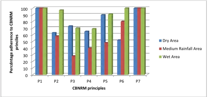
3.6.2 Adherence of CBNRM projects to the seven principles for increasing success ... 51
CHAPTER FOUR ... 54
Effects of aridity on the performance of CBNRM projects ... 54
4.1 Introduction ... 54
v
4.2.1 Household interviewee selection ... 54
4.2.2 Key Informant selection ... 55
4.2.3 CBO project manager selection ... 55
4.3 Data collection ... 55
4.3.1 Interview process ... 55
4.3.2 Secondary data collection ... 56
4.4 Data analysis ... 56
4.4.1 CBNRM projects performance in the three aridity zones ... 56
4.4.2 Influence of aridity on CBNRM projects performance ... 57
4.5 Results ... 58
4.5.1 Performance of projects in the three aridity zones ... 58
4.5.2 Projects performance relative to aridity ... 59
4.6 Discussion ... 59
4.6.1 Projects performance in each of the three aridity zones ... 59
4.6.2 Projects performance relative to aridity ... 61
CHAPTER FIVE ... 63
General discussions, recommendations and conclusions ... 63
5.1 Introduction ... 63
5.2 General discussion ... 63
5.3 Recommendations ... 66
5.4 Conclusions ... 69
List of Figures
Figure 2.1: Number of CBNRM projects/CBOs and villages covered (1993-2005) ... ………16
Figure 2.2: Growth in annual income generated by communities through CBNRM ... 17
Figire 2.3: Total estimated CBNRM incomes for different CBNRM activities in 2005 ... 18
Figure 2.4: Increase in income/value earned through CBNRM activities (1993-2005) ... 19
Figure 2.5: Map of Botswana showing its location in Southern Africa ... 24
Figure 2.6: Location of three aridity zones used in the study ... 30
Figure 3.1: Aridity zones adherence to the seven principles for increasing success of CBNRM projects ... 44
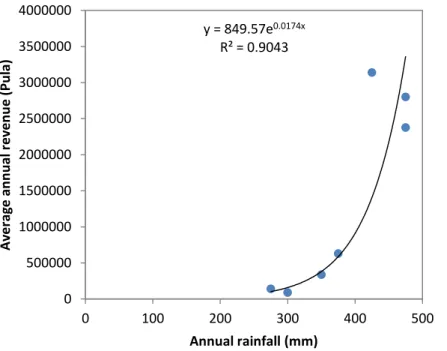
Figure 4.1: Annual rainfall and average annual income generated for each of the study projects ... 59
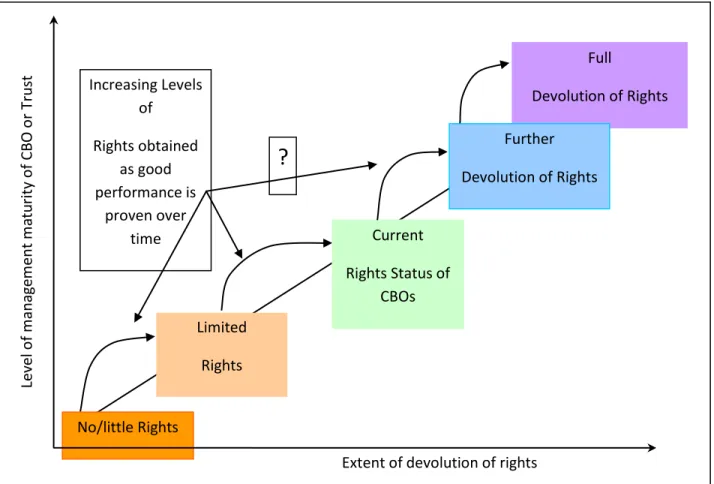
Figure 5.1: Incremental rights devolution model showing assumption of greater rights through proven, acceptable performance from an audit ... 68
vii
List of Tables
Table 2.1: National employment opportunities created through CBNRM as at 2005 ... 18
Table 2.2: Assets acquired by the communities through income from CBNRM (2005) ... 19
Table 2.3: Population, area size, commencement date and household numbers of wet area research projects ... 31
Table 2.4: Population, area size, commencement date and household numbers of medium rainfall area research projects ... 33
Table 2.5: Population, area size, commencement date and household numbers of dry area research projects ... 35
Table 3.1: Principles denotations and their measure proxies ... 40
Table 3.2: Proportion of households responses to CBNRM performance indicator variables ... 42
Table 3.3: Level of differences in performance indicator variables between the three aridity areas ... 43
Table 3.4: Performance of projects across the aridity areas based on the seven principles for increasing success of CBNRM projects ... 45
Table 4.1: Weights for the range of proportions of positive responses and their denotations .... 58
Table 4.2: Percentage proportion of household positive responses to the seven principles
Acronyms
BNRMP Botswana Natural Resources Management Programme
BRIMP Botswana Rangeland Inventory and Monitoring Project
BSAP Biodiversity Strategy and Action Plan
BWP Botswana Pula
CBNRM Community-Based Natural Resources Management
CBNRM-PPI Community-Based Natural Resources Management - Project Performance Indicator
CBO Community Based Organisation
CECT Chobe Enclave Conservation Trust
CEG Community Escort Guide
CHA Controlled Hunting Area
CSO Central Statistics Office
CTT Cgaecgae Tlhabololo Trust
DSM Department of Surveys and Mapping
DWNP Department of Wildlife and National Parks
GH Ghanzi
GLB Ghanzi Land Board
GoB Government of Botswana
IT Information Technology
IUCN International Union on Conservation of Nature
JV Joint Venture
JVA Joint Venture Agreement
JVP Joint Venture Partnership
ix
KD Kgalagadi
KDT Khwai Development Trust
KKDT Khawa Kopanelo Development Trust
KLB Kgalagadi Land Board
LUMP Land Use Management Plan
LUP Land Use Plan
MDGs Millennium Development Goals
MOMS Management Oriented Monitoring System
NACSO Namibian CBNRM Support Organisation
NEEM Nascent, Emerging, Evolving and Mature
NG Ngamiland
NGO Non-Governmental Organisation
NIP National Implementation Plan
ODMP Okavango Delta Management Plan
OKMCT Okavango Kopano Mokoro Community Trust
PA Protected Area
POPs Persistent Organic Pollutants
RAD Rural Area Dweller
RADP Rural Area Dweller Programme
RALE Registered Accountable Legal Entity
RISDP Regional Indicative Strategic Development Plan
SADC Southern African Development Community
SNV Netherlands Development Agency
TLB Tawana Land board
STMT Sankuyo Tshwaragano Management Trust
UN United Nations
UNCBD United Nations Convention on Bio-Diversity
UNCCD United Nations Convention on Combating of Desertification
UNEP United Nations Environmental Programme
UNESCO United Nations Scientific and Cultural Organisation
UNFCCC United Nations Framework Convention on Climate Change
US$ United States dollar
USAID United States Aid for International Development
WCMP Wildlife Conservation and Management Programme
WCS World Conservation Strategy
WMA Wildlife Management Area
XDT Xhauxwatubi Development Trust
1
CHAPTER ONE
Introduction
1.1 Introduction
Our planet’s rich biodiversity is the foundation which underpins human well-being (UN, 2005; IUCN, 2009). It is the interactions of humans and the ecosystems that have shaped the world and the utilisation patterns that we have today. Human well-being and continued existence is solely dependent on the environment and its associated ecosystem services. Though part of the environment, humans have through their activities brought about diverse and in most cases negative environmental changes which are evident today (Rockstrom et al., 2009). These include a build up in greenhouse gases, deforestation for agriculture and other purposes, and over-utilisation of resources that exist on earth. Of the resultant changes that have occurred, the one that has had the greatest consequences for both humans and other species is the change in vegetation cover, which has resulted in habitat loss and therefore a decline in bird and other animal species populations (Ford et al., 2009).
The human-environment interactions that have occurred over centuries have culminated in different or unique ecosystem management and natural resources utilisation patterns. Evidence of this can be found in the conservation ethics that have been enshrined within people’s religions and beliefs for centuries, and present day literature indicates that, traditionally, people relied heavily on the abundant wild natural resources that surrounded them (Fabricius, 2004; IUCN, 2009). Over time, elaborate resources management systems emerged, thus the traditional ecological knowledge systems and institutions could serve as an important entry point to sustainable management and conservation of natural resources (Phuthego and Chanda, 2004).
Rural communities world-wide are heavily dependent on the environment and natural resources for their livelihoods, through daily usages such as food provision, medicinal purposes and other uses (Millenium Ecosystems Assessment (MA), 2005). With increases in the world population,
pressure has been exerted on natural resources, especially biodiversity, and the protectionist approaches to conservation that have tended to marginalize local communities have not helped the situation (Phethego and Chanda, 2004). Though nature, in some form, has survived the rash actions of human societies that are based on ever-growing consumption of resources (IUCN, 2009), activities such as agriculture (which is the life-line of rural communities) have transformed most of the landscape (IUCN, 2009). This has also adversely affected biodiversity. Norris (2008) states that if we want to retain biodiversity in agricultural landscapes, we need to understand better the value (both social and economic) to man, and to develop mechanisms to retain the value to rural communities managing the land. Besides increases in land areas under use over time, there has also been an increase in the use of other natural resources by the rural communities.
Intensive human uses of resources in the late 19th and early 20th centuries and the rampant patterns of exploitation processes drastically affected the resources, and compromised the conservation of the natural resources and sustainable development (Amankwah, 2007). In Africa, natural resources management and development patterns were largely influenced by “imposed” colonial ideals (Fabricius, 2004), which destroyed the traditional value system and left nothing in its place (Sibanda, 1998); thus the fate of the environment and natural resources conservation was in an indeterminate state. Realizing the damaging effects of the conservation and use patterns of natural resources in the late 19th and early 20th century, the international community took initiatives to remedy the situation. Thus efficient management and sustainable use of natural resources has since become a question of survival in the entire world in the face of ever increasing population numbers (Brook et al., 2008; Lindenmayer et al., 2008; Aslin et al., 2009; Matose and Watts, 2010). It is within this realm that CBNRM was conceptualised.
1.2 Community-based natural resources management (CBNRM)
Several definitions of CBNRM have been given by different stakeholders (NACSO, 2001; Fabricius, 2004; GoB 2007b and Dressler et al., 2010). Different definitions given by these stakeholders all refer to the significance of community involvement in natural resources management and conservation, for sustainability and development. This is the basis of the
3
CBNRM approach. The Namibian association of CBNRM support organisation (NACSO, 2001) defines CBNRM as the management of natural resources under a defined plan developed and agreed to by all concerned stakeholders. The approach is community based in that the community managing the resources has the legal rights, the local institutions and the economic incentives to take substantial responsibility for sustainable use of the resources. Under the natural resources management plans, communities become the primary implementers assisted and monitored by technical services. CBNRM is also defined as a concept that is used to refer to an approach that combines rural development and natural resources conservation (Cassidy et al., 1999). It is also defined as the name commonly used for integrated approach to rural development and wildlfe conservation experimented with in the early 1980’s (Gujadhar, 2000). Of these three definitions, the definition by the Namibian association of CBNRM support organisations is more comprehensive and encampuses all issues depicted in the other two definitions and therefore that definition was adopted for the purpose of this study. There are pressing socio-economic and environmental concerns and challenges in the current millennium (Kates et al., 2009). CBNRM accentuates the importance of environmental resources in development and the need to engage communities and enhance their participation in the development process. In line with the above, Mbaiwa (2004) states that sustainable community development and natural resources management have become intertwined.
The concept of sustainable development originated from environmental thinking about the limitations of natural resources and the use of our ecosystems. Strategies for sustainable development as stipulated in Agenda 21, stress the need to integrate environmental concerns into development and have community participation in natural resources management. (GoB, 2007b). Such allusions are in line with the CBNRM concept which aims at achieving sustainable development by putting more emphasis on the importance of participatory local democracy (whereby the power to make choices and apply accountability is vested in the people rather than in committees and managers) (Child et al., 2009). CBNRM further assumes that the community is the major decision maker and community institutions have the capacity to enforce regulations (Pathak et al., 2004). The success and effectiveness of CBNRM is therefore a milestone in the attainment of sustainable development. In line with the above global trends,
the government of Botswana adopted the CBNRM concept in the early 80s as a means towards sustainable development and environmental conservation.
1.3 CBNRM in Botswana
1.3.1 Background to CBNRM in Botswana
In the early 1970s, the government of Botswana initiated the development of land use plans (LUPs) in each of the country’s eight districts (GoB, 1970). A notable characteristic in these plans was the recognition of the land use conflict between agriculture and wildlife and therefore, in an effort to resolve this, areas adjacent to protected areas (PAs) were set aside for environmental and natural resources management purposes. The areas also acted as buffer zones between the protected areas and agricultural areas. After the adoption of the Wildlife Conservation Policy in 1986, these areas became wildlife management areas (WMAs). The WMAs on tribal and state land constitute 22% of the total land area (GoB, 1992a). Wildlife and natural resources utilisation are the most appropriate land use option for these areas as the land is mostly unsuitable for arable agriculture (GoB, 1986). The WMAs also act as migratory corridors for water-dependent species during the dry season and accommodate wildlife spill-over from the parks during these migrations, and therefore prevent conflict between the protected areas and more intensive agricultural use areas (GoB, 2007a). Within the WMAs are the controlled hunting areas (CHAs), which have been zoned for various types of natural resources use (including both consumptive and non-consumptive uses) under commercial and community management (GoB, 1992a).
The government of Botswana, through the Department of Wildlife and National Parks (DWNP) with funding from United States Aid for International Development (USAID), embarked on the Botswana natural resources management programme (BNRMP) in 1989, to pursue improved conservation of natural resources, which focused mainly in the CHAs within the WMAs (Child et al., 2009). This initiative marked the commencement of the Botswana CBNRM programme. The programme emphasised community involvement in natural resources management due to a number of reasons, including:
5
government inability to effectively implement conservation policies due to the huge expanse of the countryside and limited resources (manpower) at its disposal; and
abundance of natural resources offering a unique opportunity for rural economic diversification, improvement of livelihoods and fight against poverty.
At the initial stages of the programme, there were limited or inadequate policies to guide and facilitate the programme. As the initial guidance to the programme implementation, in 1995 (20th November, 1995), the then permanent secretaries of the Ministry of Commerce and Industry and Ministry of Local Government, jointly issued a signed savingram which served to enable communities to receive and retain the benefits received from the use and beneficiation of natural resources that they had access to. To compliment this savingram, the government through the BNRMP then drafted other policy documents to guide community involvement in the resources management and utilization process. As a result, the joint venture (JV) guidelines and later the CBNRM guidelines were drafted to guide natural resources business operations between the community and private sector. These documents were complementary to the Wildlife and National Parks Act of 1992.
Earlier, in 1989 the then Ministry of Local Government Lands and Housing had also categorized the CHAs (which were the basis of CBNRM) into different natural resources use zones in a move to rationalize their management and the related development activities within these areas. Categories designated to the different CHAs were:
Community managed wildlife utilization in WMAs;
Community photographic areas in WMAs;
Commercial photographic areas; Commercial multipurpose areas;
Community managed wildlife utilization in livestock areas; and Other CHAs (GoB, 1998).
There is a total of 159 CHAs, each one having its designated primary resource use (GoB, 1992a). With the start of the CBNRM programme in 1989, some specific CHAs were allocated to specific communities residing within or adjacent to these for CBNRM purposes. Natural resources utilization patterns in the country have since been guided by the above-mentioned LUPs and settlement plans which most of the districts have enacted as depicted in the designated uses for the different CHAs.
1.3.2 Resource use patterns under the Botswana CBNRM programme
A sizable proportion of the population of Botswana residing in the remote rural areas is dependent on hunting and gathering. Through advice from the BNRMP, government then sought the commitment of resident rural communities to actively contribute to the conservation and management of natural resources through the adoption of CBNRM. The main assumptions were that by allocating management and user rights to communities who reside in the CHAs for economic benefits where natural resources occur, communities would sustainably manage and utilize these resources.
This set-up then allowed the DWNP to decentralize management responsibilities of wildlife in the WMA to communities and therefore its efforts were now concentrated in the management of protected areas (PAs). With the introduction of CBNRM in the WMAs, communities then concentrated on the management of these areas and this effectively excluded them from protected areas management, therefore abating their possible claim to the PAs (Child et al., 2009). Though excluded from the PAs management through the above explained set up, communities still had some influence in wildlife management issues as WMAs are part of the PAs (by definition). The programme also aimed at enhancing opportunities for communities to stimulate rural development through earned benefits from natural resources and therefore reduce poverty and dependence on government handouts (GoB, 2001).
1.3.3 Community eligibility criteria for involvement in CBNRM
Communities involved in CBNRM are required by government to have representative and accountable registered legal entity (RALE) or community based organization (CBO) in the form of a Trust, in order to be allocated CHAs by the land authorities through a 15 year Head-lease and,
7
in turn, be allocated wildlife hunting quotas for the CHAs by the DWNP. Detailed eligibility criteria for communities to engage in CBNRM as set out in the CBNRM Policy (GoB 2007b), are that the:
community must establish a RALE, being the CBO;
RALE must have a registered constitution or bye-laws to prove representativeness of all community members in the planned venture;
district authorities, through a technical advisory committee (TAC) under the District Commissioner’s office, must have approved the trust, and
community will then be given rights within a CHA in which it is resident, or the area adjacent to that particular community (GoB, 2007a).
Furthermore, if the community is to use the resources commercially, it is required to:
draft a land use management plan (LUMP) showing the intended natural resources use and conservation, and
then request a 15 year lease of the CHA and quotas from DWNP in case of wildlife resource utilisation.
To ensure that the above conditions were met and that there is sustainable management of the resources, the government had to, on a continuous basis; liaise closely with the communities involved in CBNRM and other stakeholders in the co-management of resources. On an annual basis the communities’ constitutions and finances are audited to ensure that all community members are involved in the decision-making process and that there is proper utilisation of financial and other benefits derived thereof (equitable utilisation of benefits).
1.3.4 Significance of CBNRM in Botswana
The economy of Botswana is largely based on the mining sector which accounts for more than 50% of the country’s gross domestic product (GoB, 2002b). Though the mining sector has grown rapidly since independence, the highly capital intensive nature of the sector has led to high unemployment and deterioration in the rural income distribution (GoB, 2002a). This leaves a large proportion of the population relying on the agricultural sector, which in turn has seen a
decline in productivity over the years due to poor soils, unreliable rainfall and persistent droughts. The Revised National Policy for Rural Development (GoB 2002a) estimates that 47% of all households in the rural areas cannot meet their basic needs from agriculture. Diversification of the rural economy is a priority and a major challenge, and also an opportunity to fight poverty and sustain livelihoods (GoB, 2007a). CBNRM offers a unique opportunity for this since the country is endowed with invaluable natural resources. The significance of CBNRM in Botswana is further highlighted in the country’s National Strategy for Poverty Reduction (GoB, 2003), which has depicted CBNRM as part of the six sustainable livelihoods programmes. There is therefore a genuine need to critically assess the performance of the programme to determine its success factors. This study is an attempt at determining these success factors and the findings will guide in the programme alignment.
1.4 Structure of the thesis
Chapter One introduces the research problem. It also provides a theoretical orientation of the thesis and highlights the origins of global environmental protection and natural resources conservation strategies and trends since the beginning of the 19th century which ultimately prompted the development and adoption of such concepts as CBNRM.
Chapter Two gives a detailed literature review on the issues pertaining to CBNRM and provides a synopsis of the performance of the Botswana CBNRM programme based on secondary data and literature review.
Chapter Three provides the methods, results and discussions related to the survey question on factors that influence the performance of CBNRM (that is, what factors influence the performance of CBNRM), and also determines whether the seven major principles for increasing the success of CBNRM projects have been adhered to in the country programme.
Chapter Four provides the methods, results and discussion related to the survey question on aridity and its effect on the performance of CBNRM (that is, how aridity influences the performance of CBNRM).
9
Chapter Five gives an overall discussion of the research findings and how they relate to the research hypothesis. This chapter also provides conclusions based on the study results, and makes recommendations on the best approaches or implementation strategies for CBNRM and improvement of the country CBNRM programme.
CHAPTER TWO
Literature review and study area
Introduction
This chapter presents a general literature review of global conservation and development events which have led to some of the important modern day natural resources conservation and development approaches, of which sustainable development and CBNRM are part of. The chapter further provides an account of the Botswana CBNRM programme from inception to the present and also provides a general introduction to the study area.
2.1 General literature review
2.1.1 Towards comprehensive environmental protection
Development processes pursued in the past two centuries involved intensive human use of natural resources and these had negative effects on the environment (Drexhage and Murphy, 2010). These development approaches excluded participation of the grassroots rural communities who depended on the natural resources for their livelihoods. In some cases communities were forced to move from areas intended for conservation. Such coercive conservation was detrimental to the rural people’s livelihoods, the environment and natural resources in general (Hitchcock, 1995). The decade of economic and political crisis in Africa in the 1980s and 1990s also exposed the weaknesses of states and challenged their continued socio-economic dominance over civil society through interventionist and intrusive state-led development strategies (Wardel and Lund, 2006). In an effort to address the apparent environmental challenges which had become more apparent during the 1970s, the first environmental conference was held in Stockholm in 1972 (UNCED, 1992). A number of initiatives to address environmental issues followed this conference over the years, including the formulation in 1980 of the United Nations Environmental Programme (UNEP), the International Union on Conservation of Nature (IUCN), the World Conservation Strategy (WCS)
11
and ultimately the holding of the 1992 Rio de Janeiro Earth summit which came up with the important Rio Declaration (UNCED, 1992).
The last is important as it came up with three significant instruments which are pertinent to natural resources conservation and sustainable development. These are:
The Rio declaration on environment and development, which recognizes the potential of indigenous people and other traditional or local people for the management and development of ecosystems through the deployment of traditional knowledge systems. Agenda 21; which is a comprehensive plan of action to be implemented at global, national
and local levels, and
The United Nations Convention on Biological Biodiversity (UNCBD); which is the world’s first legal instrument on biodiversity and its conservation. It is also significant for its objective of equitable sharing of the benefits from the exploitation and use of genetic resources (UNCBD Document, Article 8(J) and Article 10 (C)).
Other significant conventions that also came up as a result of the Rio convention were; the United Nations Framework Convention on Climate Change (UNFCCC) and the United Nations Convention of Combating Desertification (UNCCD). All these emphasise environmental and natural resources conservation, with involvement of indigenous or local people.
Subsequent to the above, through the United Nations millennium declaration (8th September, 2000), world leaders committed nations to the new global partnership to reduce poverty by setting out a series of time-bound targets with a deadline of 2015; that is, Millennium Development Goals (MDGs) (UN, 2005). MDG 7 is of particular interest to natural resources conservation as it aims at ensuring environmental sustainability, with two of its targets as, integration of principles of sustainable development into country policies and programmes and reverse loss of environmental resources, and reducing biodiversity loss, through achieving by 2010, a significant reduction in the rate of its loss.
In response to these global initiatives, regional bodies and national governments came up with a number of initiatives and programmes aimed at environmental conservation and sustainable development. The promotion of community-based sustainable use of natural resources which entails participatory conservation in the form of community-based natural resources management (CBNRM) (Stoll-Kleemann et al., 2010), whereby the indigenous communities play a significant role, is one such initiative. The Southern Africa Development Community (SADC) through its regional indicative strategic development plan (RISDP) of 1999 also recognises the environment and sustainable development as its high priority intervention areas. In cascading this to individual states within the region, individual SADC member states have devised uptake initiatives in the form of plans, programmes and creation of enabling environments in the form of enactment of policies and legislation.
2.1.2 CBNRM and sustainable development
Sustainable development as espoused in the global environmental protection initiatives seeks to reconcile the ecological, social and economic dimensions of development, now and into the future, and adopts a global perspective in this regard (Baker, 2006). The model states that: environmental stresses are linked with one another; environmental stresses and patterns of economic development are linked with one another; and environmental and economic problems are linked with social and political factors. It strives to attain social equity, economic efficiency and ecological sustainability by linking the economy, society and the ecology (Baker, 2006). Achieving progress towards sustainability thus implies monitoring and preferably improving both human and ecosystems well-being, not one at the expense of the other (Hardi and Zdan, 1997). Practically, it is rather difficult for development projects to strike a balance or to operate in an equilibrium with regard to the three and therefore the model subsists on trade-offs amongst the three areas of concern. The idea therefore expresses the inter-dependence between the people and surrounding world (Hardi and Zdan, 1997)
The sustainable development and CBNRM concepts are interlinked. The twin objectives of CBNRM which are: the improvement of rural livelihoods through benefits from sustainable
13
natural resources management and conservation of natural resources all key on sustainability. The sustainability concept is of importance in CBNRM as it has the potential to ultimately influence the way communities act and think, leading to correctly managed and controlled resource use (Aslin et al., 2009). Thus the two concepts are in consonance as sustainability is embedded in twin objectives of CBNRM, whereby a balance is struck in terms of using both scientific and traditional management systems ensuring that conservation meets local livelihood aspirations as well as scientific conservation objectives (Ostrom, 1990). This promotes development that is contained within the ecological carrying capacity of the planet, which is socially just and economically inclusive (Baker, 2006). Natural resources ownership fostered through CBNRM outcomes usher in communities’ sense of obligation to protect natural resources and to use them in a sustainable way (Lin and Chang, 2011).
Furthermore, both sustainable development and CBNRM advocate for human empowerment and non-violence in the use of natural resources and this can be attained if there is free flow of information to eradicate ignorance, poverty and any form of discrimination. CBNRM has a strong link to poverty alleviation (Dressler and Büscher, 2008), as it provides local rural communities with much required income on which to improve their livelihoods (Allison and Ellis, 2001; Hoole and Berkes, 2010). Human empowerment can be better attained through active local participation as advocated by CBNRM. This is in line with the sustainable development pillar of social equity, which places much emphasis on community participation. This essentially implies strengthening already existing and building new social organisations engaged in the planning and implementation of development projects.
In attaining ecological efficiency, use of natural resources should be within their sustained yields and for renewable resources the use should not compromise the regeneration rate. The atmosphere, many bodies of water, and large areas of soil should not exceed their absorptive limits as regards wastes of all kinds generated from the development process (Shmidheiny, 1992). The contribution of ecological sustainability to sustainable development of projects is embedded in the following strategies (Baker, 2006):
encouraging the integration of ecological consideration into economic and sector development policies;
devising anticipatory preventative strategies for development; and demonstrating that sound ecological policies also benefit development.
Ecological sustainability can therefore be maintained jointly with efforts to attain economic development (Baker, 2006). Economic efficiency is concerned with optimal use of the natural resources to meet human needs and economic growth (Baker, 2006). Emphasis is placed on the use of assimilative capacity, science and technology, and institutional arrangements in the utilisation of natural resources, as is the case with CBNRM (Baker, 2006). The adoption of multi-criteria techniques that affect trade-offs between the three pillars of sustainable development is a way to realize benefits and conservation of natural resources.
Social equity, economic efficiency and ecological efficiency are fundamental to sustainable development projects as they have to demonstrate that these could be maintained in partnership; and partnership involves weighing the economic costs of damage to ecosystems and the benefits which could be attained from conserving the ecosystems, and this is in line with the CBNRM concept (Baker, 2006).
2.2 Performance of the Botswana CBNRM programme
In line with the global and regional initiative on environmental conservation, Botswana adopted the CBNRM concept in 1989. Implementation of the Botswana CBNRM programme took the form of planner-centred participation where communities’ views were solicited on their involvement in this government-driven initiative on natural resources management, and this meant compliance with pre-set obligations or conditions (Thakadu, 2005). In planning CBNRM projects, the government also placed emphasis on the potential of the natural resource under consideration within a particular locality where a community resides.
15
2.2.1 Outcomes and general issues from the programme
Though perceived as successful, in general the CBNRM programme in Botswana has produced uneven outcomes at individual project level and this has caused some debate about the viability of the programme. A number of factors have been purported to be the source of these varied outcomes of the programme within common localities and in different parts of the country; however the evidence to validate these is incomplete.
The generally perceived success of the programme is depicted by its expansion to cover the entire countryside and its ability to have successfully established or gone through the start-up phase for most or all individual projects at community level. It has also gained recognition and been embraced by government as an important conservation initiative outside the protected areas. Despite its success, CBNRM has faced a number of challenges, which are associated either with the programme itself or with the implementation process. These challenges have long-term implications on the programme outcomes and its future implementation and due attention has to be given to them.
2.2.2 Recorded programme results from 1989-2005
Most CBNRM projects started in Botswana were spearheaded by the DWNP and therefore a majority of the projects in the country are wildlife and tourism based. There are however, some CBNRM projects based on cultural tourism and these use heritage site and cultural activities for tourism purposes. Other CBNRM projects are based on the utilisation of veldt products such as food and medicinal plants, although they are limited markets for these products. Communities operating wildlife and tourism based projects are in formal joint venture partnerships or agreements (JVAs) with private operators (GoB, 2010). These partnerships entail payment of annual land rentals for the respective community areas and also buying of wildlife hunting quotas issued to the communities by the government. In addition to the revenues accrued from the joint venture partnerships, through their respective trusts communities also get employment from private entrepreneurs and at times initiate their own business operations through revenues received and this also creates employment for the community or project
members. This model of joint venture partnership has however negated active community involvement in the actual running of the business venture. Communities have just been receipants of funds from the private partner and this does not support or provide for skills transfer to the grassroots.
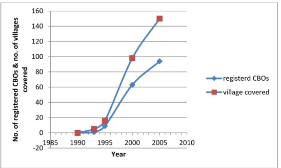
Figure 2.1 below shows the proliferation of CBOs from the programme inception till 2005 (1993-2005).
FIGURE 2.1NUMBER OF CBNRM PROJECTS/CBOSAND VILLAGES COVERED (1993-2005)
SOURCE: KCS,2006.
There was a proliferation of CBOs after registration of the first pilot project of the Chobe Enclave Conservation Trust (CECT) in 1993. The motivation for communities to engage in CBNRM was due to the revenues that such projects received directly from the utilization of natural resources in their respective areas as evidenced by the CECT. It is estimated that by 2005, a total of 94 CBOs had already been formed and these covered more than 150 villages in the country and represented a total population of approximately 135,000 or about 10% of total national population (KCS, 2006). Though registered, not all CBOs were actively operational or had projects running. -20 0 20 40 60 80 100 120 140 160 1985 1990 1995 2000 2005 2010 N o . o f r e gi ste re d CB Os & n o . o f vi llag e s co ve re d Year registerd CBOs village covered
17
Amongst communities that had designated CHAs there were high expectations of generating some revenues and even those communities without designated areas formed CBOs and requested to be allocated CHAs for CBNRM purposes. Not all started projects were viable since most of them had not conducted any feasibility studies. Figure 2.2 below shows revenues that were earned from CBNRM projects between 1993 and 2005.
2.2.2.1 Revenues accrued from CBNRM projects
FIGURE 2.2:GROWTH IN ANNUAL INCOME GENERATED BY COMMUNITIES THROUGH CBNRM
Source: KCS, 2006. (Note: US$1=BWP7)
In the first four years of CBNRM implementation in the country, revenues generated by the CBNRM projects were low and stagnant as indicated in Figure 2.2 above. This is due to the fact that only a few projects were operational. Involvement of other agencies such as the Netherlands Development Agency (SNV) in the facilitation of CBNRM in the country ushered in the increase and diversification of CBNRM activities from wildlife based projects as some of the CBOs started also utilizing veldt and forest products, crafts production and cultural tourism as shown below (Figure 2.3).
0 2000000 4000000 6000000 8000000 10000000 12000000 14000000 16000000 1993 1994 1995 1996 1997 1998 1999 2000 2001 2002 2003 2004 2005 In co m e (Pu la) e ar n e d tr o u gh CB N R M Year
FIGIRE 2.3:TOTAL ESTIMATED CBNRM INCOMES FOR DIFFERENT CBNRM ACTIVITIES IN 2005 Source: KCS, 2006. (US$1=BWP7)
Besides income generation, CBNRM projects through their respective trusts created other socio-economic benefits for their respective communities, including jobs, provision of social services (such as funds for the elderly, orphans, youth sport, funerals, scholarships and assistance for the disabled people), water reticulation at household level, provision of IT infrastructure, transport services, building of community halls at village level and toilets for households. Table 2.1 below shows the amount of employment nationally that was created through CBNRM activities in 2005 (2005 was the only year that such comprehensive data had been compiled).
TABLE 2.1: NATIONAL EMPLOYMENT OPPORTUNITIES CREATED THROUGH CBNRM AS AT 2005
Activity Employment
Trophy hunting 560
Photographic and cultural tourism 420
Veld products marketing At least 3,100
Crafts At least 4,000
Total At least 8.080
Source: CBNRM Status Report, November 2006
Mandatory employment as espoused in the JVA through the respective CBNRM activities was 780 and assets were also acquired. Table 2.2 shows the assets acquired by the communities through revenues from CBNRM in 2005.
660000 600000 12800000 3200000
Income BWP
Marketed Veld-products Craft production Trophy Hunting Photographic & cultural tourism19
TABLE 2.2:ASSETS ACQUIRED BY THE COMMUNITIES THROUGH INCOME FROM CBNRM NATIONALLY (2005)
Assets
Total number of assets owned by CBOs
Number of communities that own these assets DSTV 3 2 Internet Access 7 7 Computers 23 17 Printers 24 14 Vehicles 42 15
Source: CBNRM Status Report, November 2006
Most of these acquired assets were used communally by the communities. Vehicles, communication radios and televisions in community halls have been of great use to individuals and the entire community as they provide communication links and information.
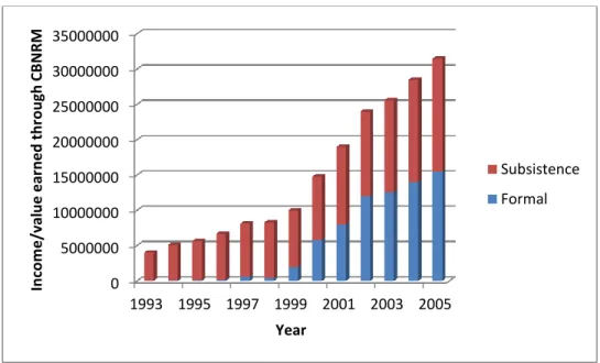
As seen above, CBNRM projects have contributed greatly to the improvement of rural economies and enhancement of livelihoods through provision of essential services, enhancing communication and bringing information to the people through television and so opening the rural communities to the outside world. Figure 2.4 below shows some of the subsistence gains from CBNRM that have been quantified in monetary terms.
Figure 2.4: Increase in income/value earned through CBNRM activities (1993-2005)
Source: KCS, 2006. (US$1=BWP7) 0 5000000 10000000 15000000 20000000 25000000 30000000 35000000 1993 1995 1997 1999 2001 2003 2005 In co m e /val u e e ar n e d t h ro u gh CB N R M Year Subsistence Formal
2.2.2.2 Involvement of communities in natural resources management (NRM)
CBNRM as a natural resource conservation programme necessitated involvement of communities in the natural resources conservation process. To this end, the CBOs had conservation aspects embedded in their respective constitutions through specific clauses which mandated them to be involved in this undertaking. The projects further employed community escort guides (CEGs) who acted as natural resources monitors in the project areas. Their role was to ensure that no illegal activities occurred in the area and to assess the status of the environment within the communities’ areas. To ensure this, communities adopted the Management Oriented Monitoring System (MOMS) as their management and monitoring framework in 2005. This was initially piloted by three CBOs. The implementation of MOMS, which mainly entailed systematic collection and recording of data on natural resources, was chiefly the responsibility of the CEGs, and by 2005 a total of 111 CEGs had been employed in 14 wildlife-based CBRNM projects (KCS, 2006).
2.2.2.3 Cash payments
At least four community projects had paid annual cash dividends to their respective household members in 2005, although some have since stopped these due to financial constraints (KCS, 2006). Amounts paid ranged from P200-P500 per annum. Some of the projects that have paid these dividends include:
• Mababe Zokotsama Community Development Trust
• Sankuyo Tshwaragano Management Trust
• Khwai Development Trust, and
• Khawa Kopanelo Development Trust.
Though overall CBNRM seems to have done well in Botswana, the majority (about 80%) of the revenues generated are from the wet zone. This area is generally important for tourism because of the abundance of wildlife, the general biodiversity and the scenic beauty, as is usually the
21
case with most wetlands in the world since they provide good breeding areas for wildlife, birds, amphibians, aquatic mammals and fish (Mbaiwa and Darkoh, 2006).
There have, however, been mixed outcomes from different CBNRM projects even within the wet areas, and some of the projects that have managed to generate substantial revenues have not been keen to reinvest these in the improvement of their communities’ livelihoods. Although communities have embraced CBNRM and play an active role in CBNRM projects in the medium rainfall and dry areas, not enough revenues and other benefits have been generated to make a significant impact on people’s livelihoods and rural development.
2.2.2.4 Conclusion
Based on data on revenues accrued, employment and accrued assets from CBNRM as shown above, CBNRM seems to have performed well in Botswana. On a regional scale, performance of CBNRM in Southern Africa has been constantly brought into the limelight in terms of its significance in contributing to both environmental conservation and rural development (Nkhata and Breen, 2010). Child and Barnes (2010) recognise that CBNRM, like democracy, is both an imperfect process and a conceptual goal, and is therefore hard to achieve in its entirety.
Further research is, however, necessary to determine whether there is consistency in the programme performance throughout the country. Information on the performance of individual CBNRM projects is vital for continuity and further improvement of the programme as it will shed light on factors that influence projects and overall programme performance. This study therefore solicits information on factors that influence the performance of CBNRM in Botswana.
2.3 Study hypothesis, objectives and key questions
The hypothesis in this study is that “CBNRM is more effective in wet areas than in dry areas due to abundant natural resources, leading to high benefits, and therefore improved livelihoods and rural development in these areas”.
The overall objective of the study is to determine whether CBNRM projects have attained the twin objectives of natural resources conservation and rural development throughout all aridity zones of the country.
The outcomes of this study are important as they will assist the government and other stakeholders in focusing the resources in areas (aridity zones) where CBNRM has the potential to make an impact and will also provide an insight on particular aspects that need attention in the country programme.
The study also aims at revealing whether the country CBNRM programme has embraced the seven major principles for improving the success of CBNRM (Fabricius, 2004).
The study research questions are:
a. What factors influence the performance of CBNRM? b. How does aridity influence the performance of CBNRM?
The seven major principles for improving CBNRM (Fabricius et al. 2004) support are: A diverse and flexible range of livelihood options must exist and be maintained. The production potential of the resource base must be maintained or improved.
Institutions for local governance and land and resource management must be in place and must be effective.
There must be economic and other benefits to provide an incentive for the wise use of the resources.
There must be effective policies and laws; they are implemented, and authority is handed down to the lowest level where there is capacity.
There should be sensitive and responsible facilitation from outside.
Local-level power relations must be favourable for CBNRM and local relations must be understood.
23
2.4 Study area
The study covers the entire country of Botswana. The total area of Botswana is approximately 582,000 square kilometres (GoB, 2000a), and the ecological zones of the country are described as a classification of the physical environment which distinguishes between the sand-covered plains in the western part of the country and the rocky plains that dominate the eastern part (GoB, 2002a). The National Settlement Policy, 1998 (GoB, 1998b) describes the country’s ecological zones as comprising the hard veldt, wet sand veldt, dry sand veldt and transition sand veldt-hard veldt. Research data were collected within the above-mentioned areas.
2.4.1 The country profile
2.4.1.1 Geography
Botswana is located in Southern Africa and has land boundaries of a total length of 4,013 kilometres with Namibia, South Africa, Zimbabwe and Zambia. Figure 2.5 below shows the geographic location of Botswana within the southern Africa region.
Figure 2.5: Map of Botswana showing its location in Southern Africa
Source: Botswana national implementation plan (NIP) of Stockholm convention on POPs (GoB, 2008)
The country’s soils are more than 70% desert sands and the Kalahari Desert lies in the south-west of the country (GoB, 2002b). The Okavango delta, the world’s largest inland delta, is in the north-west and the Makgadikgadi pan, a large salt pan, lies in the north. The lowest point is at the junction of the Limpopo and Shashe rivers, at a height of 513 m. The highest point is in the Tsodilo hills, at 1,489 m.
The annual climate ranges from months of dry temperate weather during winter to days or weeks of sub-tropical humidity interspersed with drier hot weather during summer (GoB, 2002b). Annual rainfall averages 460 mm including a range from 650 mm in the extreme north-east to less than 130 mm in the extreme south-west.
25
2.4.1.2 Population
The population of Botswana in 2003 was estimated at 1,785,000 (CSO, 2003) and unpublished 2011 preliminary census results show the current population as 2,035,000. Nearly 80% of the population of the country lives in the eastern strip where there are better soils. The preliminary results also indicate that 22% of the country’s population lives in the urban areas and the following are the distributions within each aridty zone:
The proportion of the urban population in the Wet area is five (5) percent, In the Medium rainfall area is fifteen (15) percent and
In the Dry area is two and half (2.5) percent. Source: Statistics Botswana, 2011.
General sources of livelihood in the wet area include riverine (arable) farming, livestock, fishing and in some cases hunting. In the dry area people subsist mainly on livestock farming and the livelihood sources in the medium rainfall area is a combination of those in the wet and dry areas as it is in the peripheries of the two areas (Statistics Botswana, 2011).
2.4.2 Environmental Overview
2.4.2.1 Biodiversity
Botswana‘s biodiversity is important for the sustainability of the country’s livelihood, especially in the rural areas (GoB, 2002b). Other economic sectors, such as tourism, also depend on biodiversity. One of the threats to Botswana’s biodiversity is habitat destruction and reduction emanating from the increase in population which leads to over-exploitation of the resources and factors related to development (GoB, 2002b). Some of the factors that affect biodiversity include encroachment of human settlements into the virgin areas leading to habitat destruction and biodiversity in Botswana is also affected by natural phenomena such as climate change and evolution (GoB, 2002b). It is, however, important to note that Botswana’s biodiversity represents a huge asset both economically and ecologically (GoB, 2002b). Botswana has ratified the United Nations Convention on Biodiversity (UNCBD) and, as a way of implementing and
adhering to the convention’s obligations, developed a biodiversity strategy and action plan (BSAP) in 2004. A depletion of palatable grass species and the resultant poor vegetation cover has resulted in 17% of the rangelands of Botswana being degraded (GoB, 1998a).
2.5 Scope of the study
The study focuses on defined aridity zones which are based on the country’s ecological zones as defined in the State of the Environment Report of 2002 (GoB, 2002b). However, for the purpose of this study, there is an inclusion of the medium rainfall zone, which is not classified in any of the contemporary literature of Botswana. Aridity zones identified for this study are as described below.
2.5.1 The wet area
The area is depicted by the wet sand veldt (with annual rainfall of 400mm and above), with further high inflow of water from river which have their sources from neighbouring countries (GoB, 2002b).
2.5.1.1 Socio-economic and biophysical environment of the area
Due to the abundance of water in this area, it is a haven for a wide range of wildlife species and within the area there are also pockets of fertile soils (GoB, 2002b), mainly in the Okavango Delta and the Chobe-Zambezi drainage system. Some of the country’s forest reserves are also located within this area.
2.5.1.1.1 Temperature
The temperature in this area can be described as mild, with temperatures ranging between 15 – 35°C (STMT, 2009). The highest maximum temperature recorded at the peak of the summer season is 45°C.
2.5.1.1.2 Geology
Most soils are Kalahari sands (arenosals) and often extend up to 300m deep (GoB, 2002b). The area is also covered with sediments from the larger Kalahari, mainly alluvial sands, and their
27
alteration into calcrete and silcrete and organic peat and these pockets of fertile soils are mainly found around the Okavango Delta and the alluvial plains within the Zambezi-Chobe drainage system (GoB, 2002b). A substantial portion of the area is overlain by a layer of sand commonly known as the Kalahari beds (KDT, 2007), and bedrock is only exposed in isolated areas, as a result most of the geology is concealed.
2.5.1.1.3 Vegetation
Vegetation in the area is mainly tree savannah (KDT, 2007; OKMCT, 2008 and STMT, 2009). This vegetation community is, however, dominated by woodland vegetation, interspersed by dry deciduous forest with grassland and sedges that are typical of the flood plains. Vegetation composition and abundance is influenced by rainfall patterns and displays, flood regime landscape characteristics (STMT, 2009). It should, however, be noted that increase of elephant populations in the area (north-western parts of Botswana) has also resulted in the transformation of the riparian woodlands to grasslands (GoB, 2002b). It also contains a number of woody tree species including certain species that are listed as protected in the Forest (Amendment) Act (2005) OKMCT, 2008).
2.5.1.1.4 The wildlife resource
There is a wide diversity of wildlife resources in the area and it is estimated that there are over 160 species of mammals, birds, amphibians and reptiles (OKMCT, 2007). There are more than 34 species of mammals larger than a jackal within this area, including both herbivores and carnivores (OKMCT, 2007). The large diversity of habitats in the area, which ranges from dry deciduous forest to swampy wetlands, in addition to supporting substantial populations of herbivores and carnivores, also provides habitats for a variety of bird species. Besides the above-mentioned wildlife resources, the area is also rich in fish resources which are used for both recreation and subsistence purposes by the local communities. The area is the richest resource area in the country, in terms of biodiversity (GoB, 2002b).
2.5.2 The medium rainfall area
This depicts the areas lying in the periphery of the wet area and the dry area (transition area from wet to dry) and the annual rainfall of this aridity zone is between 350mm and 390mm (GoB, 2002b). This zone lies on the edges of Ngamiland, Chobe and Central districts, and the Kgalagadi-Ghanzi districts.
2.5.2.1 Biophysical environment of the area
The area is unique in the sense that it exhibits some wet and dry area species, though sporadically and in small numbers. This is due to the fact that the area’s physical elements which play a critical role in influencing distribution, abundance and diversity of species are an interface of the two areas (GoB, 2002b).
2.5.2.2 Geology
The area is predominantly undulating and sloping gradually towards the east and south, and much of the surface is covered with sandy soils, with the surface area occasionally broken by isolated rocky outcrops (CTT, 2010). The soils are predominantly sandy arenosols, ferralic and haplic which are deep well-drained soils with low water retention capacity (GoB, 2002b). The area’s proximity to flood areas such as the Okavango delta, offers access to fluvisols which develop on alluvial deposits and these can be regarded as fertile soils.
2.5.2.3 Biodiversity
The vegetation of the area is mainly shrub-savannah with patches of isolated woodlands (GoB, 2002b). The most prominent tree species in this area are Terminalia sericea, Lonchocarpus nelsii, and Acacias, and the grass species include Schmidtia kalaharienscens, Aristida spp.,
Eragotis spp. and Aanthopora spp. (GoB, 2002b). The dominant animal species in this zone include those found in both the wet and dry areas.
2.5.3 The dry area
This is depicted by mainly the dry sand veldt with an annual rainfall of less than 350mm. The area is characterized by low rainfall and lack of surface water resources, making the zone highly dependent on underground water (GoB, 2002b).
29
2.5.3.1 Biophysical environment of the dry area
The dry area falls entirely within the Kalahari ecosystem, which is essentially a large sand-filled basin (GoB, 2002b). This feature and other physical elements play a major role in influencing the distribution, abundance and diversity of biological species in the area.
2.5.3.2 Climate
The Kalahari climate is classified as semi-arid of low altitude, hot steppe type with some summer rainfall (KKDT, 2007). The rainfall is highly variable within and between years as well as spatially, ranging at around 225mm to 250mm (GoB, 2002b). Average daily temperatures in summer are 20°–34° Celsius, although maximum temperatures can reach 45° Celsius and in winter they can fall as low as -8° Celsius with dry frosts (GoB, 2002b). Frequent droughts in the area have led to plants and animals characterized by their adaptation to the conditions of water scarcity, therefore resulting in the carrying capacity of the land being low or limited (GoB, 2002b).
2.5.3.3 Biodiversity
The vegetation of the area consists mainly of thorn trees and broad-leafed shrubs (KKDT, 2007). The dominant plant species are Acacia erioloba, Acacia luederitzii, Acacia mellifera, Terminalia sericia, Grewia flava and Grewia retinervis. Grass species include Anthephora pubescens,
Eragrostis lehmanniana, and Schmidia pappophoroides. There is a diverse range of wildlife species in the Kalahari though the populations are generally low.
2.6 Study projects within the aridity zones and the selection criteria
2.6.1 Selection criteria
A total of seven CBNRM projects were selected for evaluation (out of a total of sixteen (16) projects nationally) within the three above-mentioned aridity zones, and within the zones, the numbers of projects selected were as follows: three in the wet area, two in the medium rainfall area and two in the dry area. The selection criteria of projects were based on the following: Selected projects for evaluation are primarily wildlife and tourism based.
The projects have a defined CHA (gazetted area with defined boundaries).
They have 15-year lease from the land authority for the use of the area and natural resources.
They have an institution with a registered deed of trust or constitution and have been in existence for at least ten (10) years.
The projects are among are the oldest within their aridity zone (that is, the oldest or earlier registered ones were selected in each area).
The figure below shows the location of the three study aridity zones.
Key: Dry area; Medium rainfal area; Wet area; FIGURE 2.6:LOCATION OF THREE ARIDITY ZONES USED IN THE STUDY
Source: Adapted map from Botswana national implementation plan (NIP) of Stockholm convention on POPs (GoB, 2008)
2.6.2 Selected projects in the wet area
The three selected projects for evaluation within the wet area were:
Okavango Kopano Mokoro Community Trust (OKMCT) which operates in CHA NG 32.
Sankuyo Tshwaragano Management Trust (STMT) which operates in CHAs NG 33 and NG34.
31
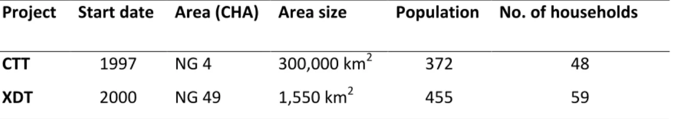
2.6.2.1 Profile of the projects
All study projects in the wet area are within the Okavango delta. Many people residing here derive their livelihoods from the area and it is also economically valuable as it serves both as a source of revenue from a number of economic activities which include tourism and it is a source of water for the region (ODMP, 2006). Figure 2.6 below shows the location of the study projects or CHAs (NG 18, NG 32 and NG 33/34) in the wet area. Also within this figure are the two medium rainfall area study projects or CHAs: NG 49 for the XDT and NG 4/5 for the CTT, which apparently lie within the boundaries of Ngamiland district.
2.6.2.2 Human population
The total population of the three sampled projects is 2,994, and more details of the projects are provided in Table 2.3 below.
TABLE 2.3:POPULATION, AREA SIZE, COMMENCEMENT DATE AND HOUSEHOLD NUMBERS OF WET AREA RESEARCH PROJECTS
Project
Start date Area (CHA) Area size Population No. of households
KDT 2000 NG 18 1,812 km2 395 59
STMT 1995 NG 33/34 9,300 km2 540 78
OKMCT 1997 NG 32 1,225 km2 2,122 300
Source: CSO, 2001 and Projects’ files and LUMPs
There are six officially recognized villages of the OKMCT: Ditshing, Daunara, Quqao, Xaxaba, Boro and Xaraxao, but none of these villages has been gazetted or recognized as an official village by government (OKMCT, 2007). According to documentation in the NG 32 land use management plan (LUMP) (OKMCT, 2007), the villages were formed around the 1980s. With the drying up of the downstream channels of the delta due to reduced inflow, there was an influx of people from downstream areas such as Thamalakane River in search of natural resources such as fish, reeds and grass in the wet upstream areas. The population within these villages is