A GIS-Based Integrated Infrastructure Management System
Adelino FERREIRA and Anabela DUARTE, PortugalKey words: Geographic Information System, Infrastructure management, linear referencing
system, engineering survey
SUMMARY
The infrastructure departments of the Portuguese municipalities need to make great efforts in beginning or continuing to use advanced information technology tools to increase institutional productivity and effectiveness in managing their municipal infrastructures. Nowadays they use or are beginning to use independent management systems for each type of infrastructure, i.e., road pavements, bridges, signs, water pipelines, sewer pipelines, parks, etc. In the future, they need to begin the development of an Integrated Infrastructure Management System (IMS). This paper focuses on the issues and needs that emerged from some studies developed by the authors involving the implementation of transportation management systems in local municipalities. This paper first introduces and discusses the functions of various participating divisions inside a municipal department of infrastructures. Then, the paper identifies the issues and needs that must be fully understood and considered in the development of an Integrated Infrastructure Management System. Doing so involved determining and standardizing an effective base linear referencing system (LRS) to meet its needs, standardizing data terminology, determining the shared data needs of the several divisions inside the department of infrastructures, and developing a comprehensive database design with focused attention given to the types of data analysis functions performed by each division. The paper includes the application of the IMS in road maintenance management and road safety management. The two sub-systems, a road maintenance management system and a road safety management system use the same base linear referencing system. In both sub-systems, in order to handle dynamic segmentation, the road network model is composed by road segments with (x, y) coordinates and measure (m) values.
The final section of the paper comprises a synthesis of the conclusions reached so far and a statement of prospects for future research.
A GIS-Based Integrated Infrastructure Management System
Adelino FERREIRA and Anabela DUARTE, Portugal1. INTRODUCTION
Public and private agencies have always tried to maintain their infrastructure assets in good and serviceable condition at a minimum cost; therefore, they practiced infrastructure management. However, as most of the nation’s infrastructure systems reached maturity and the demands placed on them started to rapidly increase in the mid- 1960s, infrastructure agencies started to focus on a systems approach for infrastructure management. This process has lead to today’s Asset Management concept. The process started with the development of pavement management systems (PMS), continued with bridge management systems (BMS) and infrastructure management systems (IMS), and has recently evolved into asset management (Ferreira and Flintsch, 2004).
One milestone in the development of engineering management systems is the concept of integrated infrastructure management systems. An infrastructure management system is defined as the operational package that enables the systematic, coordinated planning and programming of investments or expenditures, design, construction, maintenance, rehabilitation, renovation, operation, and in-service evaluation of physical facilities. The system includes methods, procedures, data, software, policies, and decision means necessary for providing and maintaining infrastructure at a level of service acceptable to the public or owners.
To effectively plan, construct, manage, and maintain our transportation assets requires that we first effectively model it using some form of an information system (Hall, 2004). Ideally we would utilize this information system in an automated manner using a range of advanced technologies. This type of system is complex and mandates a need for integration and consideration of data sharing and security. Addressing these issues and needs is critical to building an information system to meet the ever increasing social, economic, and environmental demands placed upon our transportation infrastructure (Rasdorf et al., 2000). The infrastructure departments of the Portuguese municipalities, including Lisbon, Coimbra, Oliveira do Hospital, Oliveira do Bairro, and other municipalities, manage their infrastructures using a number of systems or programs maintained by different divisions inside the department of infrastructures. Each system or program generates and maintains a large amount of information in separate and independent databases. Many of this information are processed, analyzed, and shared/used by more than one division in more than one format. All data about municipal infrastructures have a spatial component. That spatial component represents an area such as a highway corridor, a linear feature such as a road and a point feature such as a sign or the location of an accident.
The existing municipal databases and data management system design traditionally have not been effective at allowing division within the departments of infrastructures to use or share data as extensively or as easily as should be the case.
One major reason for this lack of sharing has been that the spatial component of the data has not been effectively or correctly associated with the attribute data. This has led to problems in the quality, integrity, duplication, access, and availability of the databases in municipal
departments of infrastructures. Consequently, the decisions that are based on such data are significantly affected. This, in turn, has economic implications when it comes to ongoing operations or to the overall strategic planning of future transportation infrastructure investments.
There are several applications in development of municipal infrastructure management systems (Lee and Deighton, 1995, Quintero et al., 2003). The infrastructure managers have discovered that they possess different databases and that each one contributes significantly to the mission of the infrastructures department that owns and maintains it. They have recognized the need to combine and to explore relationships among various data resources, and, when possible, to make them or part of them available to other organizations and to the public. Doing so will increase institutional effectiveness and productivity. But these different databases also have different levels of precision and accuracy in their data content. Additionally, a variety of data formats, ranging from paper files to relational tables, are used. There are also no accepted standards or practices for dealing with spatial issues, originating great diversity.
2. STRUCTURE OF A MUNICIPAL DEPARTMENT OF INFRASTRUCTURES
2.1 Introduction
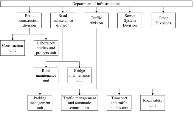
Presently, there are many existing data in use by different divisions within an infrastructure department. In Figure 1 one can see an example of the different divisions within an infrastructure department that we are going to consider in this section, even that in Portugal one can verify a great diversity of administrative structures. This example is based on the administrative structure of the Lisbon’s department of infrastructures.
This section examines the scope, nature, and functions of each division to understand the data resource needs by each division. This is fundamental so that the design of a proposed Infrastructure Management System (IMS) accommodates all the existing data and meets the existing needs of the divisions, i.e., it must support the data entry and management functionality required, it must support the data needs of their application programs, it must support the standard queries of interest to these divisions and it must provide the reporting capabilities they utilize (Rasdorf et al., 2000).
2.2 Road Construction Division
The Road Construction Division (RCD) is responsible for both the design and the construction of new municipal roads or the expansion of an existing road to meet the traffic demands. Part of the RCD’s mission is to control the design, the quality of the construction and the cost of the new roads. There are several other tasks that are performed by the RCD. Some of these tasks are field data collection, laboratory studies and material analysis.
Department of infrastructures Road construction division Road maintenance division Traffic division Sewer System Division Other Divisions Construction unit Laboratory studies and projects unit Road maintenance unit Bridge maintenance unit Parking management unit Traffic management and automatic control unit Transport and traffic studies unit Road safety unit
Figure 1 - Administrative structure of an infrastructure department
2.3 Road Maintenance Division
The Road Maintenance Division (RMD) is responsible for the maintenance of the municipal’s road network. Part of the RMD’s mission is to ensure that the municipal’s road network is above a reasonable level of quality and performance at a reasonable cost. There are several other tasks that are performed by the RMD. These tasks include field data collection and training, pavement analysis, pavement rehabilitation design, the implementation and use of a pavement management system (PMS) and a bridge management system (BMS).
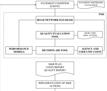
The Road Maintenance Unit is responsible for implementing, maintaining, and using a PMS to define maintenance and rehabilitation (M&R) strategies for the pavements of the municipal’s road network. The main components of a PMS are (Figure 2): the road network database; the quality evaluation tool; the models used to predict pavement performance; the agency and user unit costs; and the decision-aid tool. The road network database is used to store information on road geometry, traffic loadings, pavement condition, pavement history, M&R actions, agency and user costs, etc. All data is referred to a network model consisting of geo-referenced nodes and sections. The information stored in the database is used by all the other components of the PMS. That why it is called the more important component of a PMS.
The Bridge Maintenance Unit is responsible for implementing, maintaining, and using a BMS to define M&R strategies for the bridges of the road network. The structure of a BMS is similar to the structure of a PMS that is represented by Figure 2.
DECISION-AID TOOL QUALITY EVALUATION TOOL PERFORMANCE MODELS AGENCY AND USER UNIT COSTS
PAVEMENT DISTRESSES CATALOGUE M&R PLAN COSTS REPORT QUALITY REPORT SHORT-TIME M&R ACTIONS PAVEMENT CONDITION SURVEY
ROAD NETWORK DATABASE
PMS
IMPLEMENTATION OF M&R ACTIONS
Figure 2 - Structure of a Pavement Management System
2.4 Traffic Division
The Traffic Division (TD) includes the Parking Management Unit, the Traffic Management and Automatic Control Unit, the Transport and Traffic Studies Unit, and the Road Safety Unit. In this section we are giving a particular reference to the Road Safety Unit (RSU). This unit collaborates with the Road Safety District Commission that is managed by each Portuguese District Civil Government. The RSU is responsible for planning, designing, developing, implementing, and evaluating appropriate engineering response strategies that deal with road safety concerns throughout the municipality.
One major function of the RSU involves the collection and analysis of data that permit the identification of safety needs of special user groups such as pedestrians, bicyclists, older drivers, motorcyclists and commercial vehicles. Another function of the RSU is concerned with identifying potentially hazardous roadway locations throughout the municipal’s road network. The RSU uses programs that examine crashes at several location types, including intersections, interchanges and bridges, and also examine different kinds of crash situations, including pedestrians, wet pavement conditions, rear-end crashes, head-on crashes, and night-time crashes. The RSU is also responsible in establishing countermeasures, setting priorities, and monitoring and evaluating selected countermeasures.
The Department of structures can contain other divisions and each one of them will have proper functions. All the maps that show graphical representations of data used by the infrastructure department can be produced using Geographic Information Systems (GIS) or Computer-Aided Drafting (CAD) packages of software.
3. INTEGRATED MUNICIPAL INFRASTRUCTURE MANAGEMENT SYSTEM 3.1 Introduction
An Integrated Infrastructure Management System, taking into consideration all the components of the municipal infrastructures, allows defining integrated decisions of maintenance and rehabilitation. For example, if the pavement condition is poor and the sewer pipeline had more than two breaks in the last year, then replacing the sewer pipeline and reconstructing the pavement is an appropriate integrated decision.
There are two ways to develop an integrated infrastructure management system. The first is to maintain the data in the current diverse format used and to develop tools and methods that support data warehousing, and access across multiple platforms and formats. Alternatively, one may redesign the entire data resource using a common format. The first alternative allows each organizational division to undertake the least change. However, complex tools and methods are required to link its data to that of other divisions. The management of the linkages and the formats becomes problematic. But an even greater problem is that data may be spatially represented differently in each database. As a result, the actual spatial location of physical components cannot easily be determined. Thus, the data cannot effectively be used in combination with each other which allows robust graphical and spatial display and analysis, or with a GIS, for that matter.
The second alternative provides an opportunity to design a common spatial framework that alleviates the majority of the problems noted above. However, this approach introduces organizational impacts and requires significant restructuring and rebuilding of existing databases.
With the proliferation and increased use of advanced information technologies such as GISs and database management systems (DBMSs), the municipal infrastructure departments begin to recognize the need to provide a degree of standardization in the representation, management, and use of data. The integrated system will permit to combine efficiently tabular and spatial data that support queries, analysis, and report generation. For the Portuguese municipalities the best choice is the second alternative, i.e., redesign its entire information resource. Doing so involved determining and standardizing an effective base linear referencing system (LRS) to meet its needs, standardizing data terminology, determining the shared data needs of the several divisions inside the department of infrastructures, and developing a comprehensive database design with focused attention given to the types of data analysis functions performed by each division.
3.2 Base Linear Referencing System
The municipal infrastructure departments collect data about linear features, such as highways, city streets, rivers, and pipelines as well as water and sewer networks. In most GISs, these features are modeled in two dimensions using (x,y) coordinates. While these systems work well for maintaining features with static characteristics, these organizations have realized that their linear features often have characteristics that are more dynamic in nature. To handle this, these organizations have developed linear referencing systems to model their data. Linear referencing systems store spatial data with respect to a known location along the linear
feature being modeled, such as an accident along a highway, a bridge along a city street, a flow gauge along a river, or a manhole along a sewer network (ESRI, 2001, 2003a, 2003b). Linear Referencing Systems (LRSs) are used to manage and promote the analysis of spatial data elements on transportation networks (Rasdorf et al., 2000). An LRS includes techniques for storing, maintaining, and retrieving location information. An LRS may incorporate one or more linear referencing methods (LRMs). An LRM is a way to identify a single location, that is, to reference a single position with respect to a known point. There are several types of LRMs that can be employed in a GIS project. These include route measure, route marker-offset, link-node, x-y coordinate, address methods, etc. With some simplification one can said that location in all of these methods is described in terms of a linear feature and a position, or measure, along it. This measure can be the absolute distance from the beginning of the linear feature or can be the relative distance from a predefined point along the linear feature. As such, two key linear referencing methods can be identified: route measure and route marker-offset. Most other LRMs can be treated as hybrids of these two.
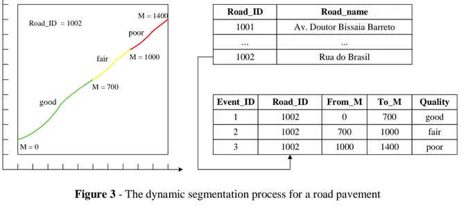
In GISs, every feature has a geometry associated with it. A feature can have one of these types of geometries: point, multipoint, polyline, or polygon. Each geometry is composed of two-dimensional (x,y) or three-dimensional (x,y,z) geographic coordinates. In order to handle dynamic segmentation, a feature’s geometry, instead of being composed of (x,y) coordinates, must be composed of (x,y,m) or (x,y,z,m) values. Dynamic segmentation is the process of transforming linearly referenced data (also known as events) that have been stored in a table into features that can be displayed and analyzed on a map. For example, the Road Maintenance Division (Figure 1) may segment road pavements dynamically according to the quality of the pavement surface (Figure 3). For the road Rua do Brasil (road_ID = 1002), the pavement is in good condition from the beginning to 700 meters, it is in fair condition from 700 to 1000 meters, and it is in poor condition from 1000 to 1400 meters. Attribute information describing quality characteristics specific to each road segment can then be maintained without splitting the road network.
Road network Road_ID = 1002 fair good poor Event_ID 1 2 3 Road_ID 1002 1002 1002 From_M 0 700 1000 To_M 700 1000 1400 Quality good fair poor M = 0 M = 700 M = 1000 M = 1400 Road_ID 1001 ... Road_name
Av. Doutor Bissaia Barreto ...
1002 Rua do Brasil
The dynamic segmentation process imposes two requirements on the data (Herman, 2002, Cadkin, 2002a, 2002b): each event in an event table must include a unique identifier and position along a linear feature; and each linear feature must have a unique identifier and measurement system.
When data is linearly referenced, multiple sets of attributes can be associated with any portion of an existing linear feature, independent of its beginning and ending. These attributes can be displayed, queried, edited, and analyzed without affecting the underlying linear feature’s geometry. In some GISs (ESRI, 2003b), the terms routes, route locations, and route events are used when one are talking about linearly referenced features. A route is any linear feature, such as a city street, highway, river, or pipe, that has a unique identifier and a measurement system defined (x,y,m). This measurement system defines discrete locations along the linear feature.
There are two types of route locations that can be modeled in a GIS: point and linear events. Point route locations describe discrete locations on a linear feature (such as an accident along a highway, a bridge along a road, a pedestrian crossing along a city street, a flow gauge along a river, a manhole along a sewer network, or a pipeline leak) and require only one measure value. Linear route locations describe portions of a linear feature (such as a road segment with accumulation of severe accidents along a highway, a pavement segment with bad surface quality along a city street, or cracking along a sewer pipeline) and require two measure values, typically referred to as the From and To measures. Route locations and associated attributes stored in a thematic table are known as route events or simply events. A route location description requires a unique identifier for the linear feature and the measure value(s) appropriate to the event type. Dynamic segmentation supports event tables in a number of formats including INFO, Microsoft Access, dBASE, Oracle, Microsoft SQL Server, delimited text files, and databases accessed via OLE DB providers.
The proposed base LRS uses a route measure linear referencing method and is an attempt to provide a common referencing platform in which different data types can be represented spatially in a network structure in a standardized manner. The base LRS is intended to be the nucleus of the relational database and the GIS, i.e., it is the exclusive way to locate features that are a part of, or are located along, a particular road. The use of a base LRS also allows municipal divisions to incorporate additional databases into the Integrated Infrastructure Management System at some future time without changing their existing spatial referencing systems (Perone, 1997). It is, therefore, highly expandable.
4. CASE STUDY
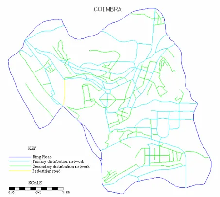
The performance of the proposed base LRS was tested with the development of an IMS for the city of Coimbra, the third-largest Portuguese city, with approximately 100,000 inhabitants. Initially, the system was developed using the MGE GIS from Intergraph. At this moment it is in process of transference for ArcGIS from ESRI.
The city’s main road network, displayed in Figure 4, has a total length of 75 km, and the corresponding network model has 254 segments. The ring road comprises 14 km and 27 segments. The primary distribution network has 32 km and 119 segments. The secondary distribution network comprises 29 km and 108 segments.
Figure 4 - Coimbra’s main road network
The Road Maintenance Division (RMD) is responsible for the maintenance of the municipal’s road network. One task that must be performed by the RMD is the implementation and use of a pavement management system (PMS). The Road Maintenance Unit is responsible for implementing, maintaining, and using a PMS to define maintenance and rehabilitation strategies for the pavements of the municipal’s road network.
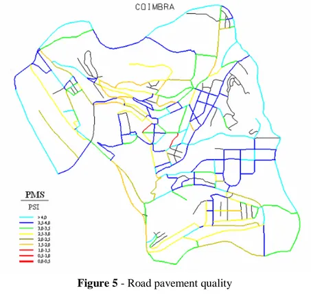
In this PMS, the quality of road pavements is evaluated through index PSI (Present Serviceability Index) adopted by American Association of State Highway and Transportation Officials (AASHTO, 1993), considering cracking area, rut depth, surface disintegration and longitudinal roughness. Figure 5 shows the PSI representation at 9 levels for Coimbra’s road network.
Figure 6 displays the maintenance and rehabilitation interventions to be performed across Coimbra’s road network on the first year of the planning time-span. This maintenance plan is defined by the Decision-Aid Tool of the PMS considering the minimization of total discounted costs involved in the M&R interventions carried out in the segments of the road network over a planning time-span, while keeping pavements above given quality standards (Ferreira et al., 2002, Ferreira and Flintsch, 2004). Both, the quality of road pavements and the M&R interventions, are represented spatially in a network structure using the same base LRS.
Figure 5 - Road pavement quality
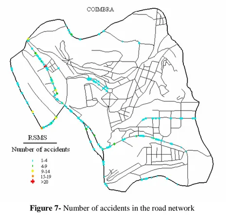
The Traffic Division (TD) includes the Road Safety Unit (RSU) that is responsible for planning, designing, developing, implementing, and evaluating appropriate engineering response strategies that deal with road safety concerns throughout the municipality. One task that must be performed by the RSU is the implementation and use of a Road Safety Management System (RSMS). The RSMS uses programs that examine crashes at several location types, including intersections, interchanges and bridges, and also examine different kinds of crash situations, including pedestrians, wet pavement conditions, rear-end crashes, head-on crashes, and night-time crashes (Smith, 2000). This system is used for making roadway security studies about road accidents that occurs in Coimbra’s road network.
Figure 7 displays the number of accidents in Coimbra’s road network. One can see that there is an intersection with more than twenty accidents during one year. For this site it must be done a particular road safety study to eliminate or reduce the number of accidents.
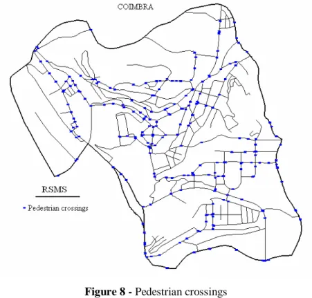
Figure 8 shows the pedestrian crossings in Coimbra’s road network. One can make some spatial operations, for example, the intersection of the two layers (accidents and pedestrian crossings) and buffers, to see if there is any link between them.
The last map (Figure 9) represents the quality of manhole covers that are a component of the sewer system. This map is also produced using the same base LRS.
Figure 8 - Pedestrian crossings
5. CONCLUSIONS
The proposed base LRS for an Integrated Infrastructure Management System is an attempt to provide a common referencing platform in which different data types can be represented spatially in a network structure in a standardized manner. The base LRS is intended to be the nucleus of the relational database and the GIS, i.e., it is the exclusive way to locate features that are a part of, or are located along, a particular road. The use of a base LRS also allows municipal divisions to incorporate additional databases into the Integrated Infrastructure Management System at some future time without changing their existing spatial referencing systems. It is, therefore, highly expandable. The Integrated Infrastructure Management System, taking into consideration all the components of the municipal infrastructures, allows defining integrated decisions of maintenance and rehabilitation.
REFERENCES
AASHTO (1993) Guide for Design of Pavement Structures. American Association of State Highway and Transportation Officials, Washington, DC.
Cadkin, J. (2002a) Dynamic Segmentation in ArcGIS. ArcUser, July-September, 52-54. Cadkin, J. (2002b) Undestand Dynamic Segmentation – Working With Events in ArcGIS 8.2.
ArcUser, October-November, 40-43.
ESRI (2001) Linear Referencing and Dynamic Segmentation in ArcGIS 8.1. An ESRI White Paper, 1-56.
ESRI (2003a) EuroTransport GIS e-Newsletter #1. ESRI White Paper, 1-56.
ESRI (2003b) Linear Referencing in ArcGIS: Practical Considerations for the Development of an Enterprisewide GIS. An ESRI Technical Paper, 1-22.
Ferreira, A. and Flintsch, G. (2004) Life-Cycle Cost Analysis System for Infrastructure Management, Proceedings of the ICCES04 - International Conference on Computational and Experimental Engineering and Sciences, pp. 1687-1692, Madeira, Portugal.
Ferreira, A., Picado-Santos, L. and Antunes, A. (2002) A Segment-Linked Optimisation Model for Deterministic Pavement Management Systems, The International Journal of Pavement Engineering, Vol. 3 (2), pp. 95-105.
Hall, J. (2004) Development of an Implementation Plan for a Geographic Information System: Case of Lincoln County, International Journal of Information Management, No. 24, 267-275.
Herman, E. (2002) Advantages of a Bi-Directional Dynamic Segmentation Route System, Proceedings of the Annual ESRI International User Conference (available for download at http://gis.esri.com/library/userconf/proc02/pap1210/p1210.htm).
Lee, H. and Deighton, R. (1995) Developing Infrastructure Management Systems for Small Public Agency, Journal of Infrastructure Systems, Vol. 1, No. 4, 230-235.
Perone, S. (1997) Integrating Transportation Modelling Networks Using Dynamic Segmentation, Proceedings of the Annual ESRI International User Conference (available for download at
http://gis.esri.com/library/userconf/proc97/proc97/to450/pap417/p417.htm).
Quintero, A., Konaré, D. and Pierre, S. (2003) Prototyping an Intelligent Decision Support System for Improving Urban Infrastructures Management, European Journal of Operational Research, Nº. 162, 654-672.
Rasdorf, W., Shuller, E., Poole, R., Abudayyeh, O. and Robson, F. (2000) Information Management at State Highway Departments: Issues and Needs, Journal of Transportation Engineering, Vol. 126, No. 2, 134-142.
Smith, R. (2000) Implementing GIS-based Highway Safety Analyses: Bridging the Gap, Proceedings of the Annual ESRI International User Conference (available for download at http://gis.esri.com/library/userconf/proc00/professional/papers/PAP888/p888.htm).
BIOGRAPHICAL NOTES
Adelino Ferreira is Professor of the Department of Civil Engineering of the Faculty of
Sciences and Technology of the University of Coimbra, in Portugal. He had been involved, for many years, in the fields of Geographic Information Systems, Infrastructure Management Systems, Road Maintenance, Maintenance Decision-Aid Tools, Road Safety Management, Safety Audits, doing research and technology development and transfer for the Portuguese Road Administration and Municipalities. Beyond that he is the team leader of the SAPIENS Project POCTI/ECM/46461/2002 - A Deterministic Segment-Linked Pavement Management System, Financed by the Portuguese Science and Technology Foundation, and a team member in the Project “Development and implementation of the Portuguese Pavement Management System", financed by the Portuguese Road Administration. He is member of iSMARTi – International Society for Maintenance and Rehabilitation of Transport Infrastructures, member of AIPCR – World Road Association, and member of the Portuguese Engineering Association.
Anabela Duarte is Civil Engineer in the Coimbra City Council, in Portugal. CONTACTS
Adelino Ferreira
Civil Engineering Department Polo 2 - Pinhal de Marrocos 3030-290 Coimbra
Portugal
Tel. +351.239797101 Fax +351.239797142 Email: [email protected] Web site: www.dec.uc.pt Anabela Duarte
Coimbra City Council Praça 8 de Maio 3000-300 Coimbra Portugal Tel. +351.239857500 Fax +351.239820114 Email: [email protected] Web site: www.cm-coimbra.pt