Valuation of metropolitan open space; presenting the research framework
paper for the 45th congress of the European Regional Science AssociationAugust 23 –27, 2005 Amsterdam, the Netherlands
Eric Koomen, Jasper Dekkers, Mark Koetse, Piet Rietveld, Henk Scholten
Faculty of Economics and Business Administration Department of Spatial Economics
Vrije Universiteit Amsterdam, The Netherlands
fax: 31-20-5986004
email corresponding author: [email protected]
Abstract
In order to effectively incorporate the concern for open space in metropolitan planning, a quantitative valuation of this asset is needed. An environmental-economic framework is described here that assesses various societal values that can be attached to open space. Two complementary methods will be applied in this study: a hedonic pricing method to assess the impact of open space on residential property values and a stated preference approach to establish the value of open space for recreational purposes. This paper describes the research framework and the setup for the hedonic housing prices study. The latter analysis will be supported by the use of Geographic Information Systems (GIS).
Keywords: land use, open space, hedonic price theory, GIS JEL-codes: C51, C53, R14, Q24
1. INTRODUCTION
Land use planning in essence tries to reconcile the various, often diverting interests of different stakeholders. This is an especially complex task in the heterogeneous landscape surrounding the bigger cities in metropolitan areas. One of the major planning concerns here is to do justice to the specific value that society connects to the open space that surrounds cities. This value and the ensuing externalities have, however, received little attention in the theoretical literature on urban land use based on the seminal works of Alonso (1964), Muth (1969) and Fujita (1989).
Economists have developed a number of procedures which, at least in the case of some externalities, provide reasonable estimates on the monetary value of some of the amenities of open space, despite the remaining uncertainty and dispersion in values produced (for example see Button, 1993). In recent years the level of sophistication used in this process has risen considerably, for example in the work on transport by Friedrich and Bickel (2002) and by Mackie and Nellthorp (2001). Nevertheless, some environmental cost categories have not received the due attention in valuation studies. Important examples include the fragmentation effects of infrastructure and visual intrusion of man-made objects that strongly affect the valuation of open space from a societal perspective. As a result, such effects are often not fully included in metropolitan planning. The project set out in this paper addresses this point in a more systematic and integral way than has been pursued so far. Based on existing theoretical work, indicators for open space are developed that incorporate elements of ecological, economical as well as societal values.
This paper first introduces the problem at hand and then conceptualises the open space research object. We will then present the methodological-technical research framework and discuss one of its main components: the hedonic housing prices study.
2. PROBLEM DEFINITION
The current complex metropolitan landscape consists of green, open areas adjacent to and enclosed by the urban environment. Changes in this landscape are a delicate matter, because they affect sustainability, the environment and scenic quality, as we see in processes like urban sprawl, intensive outdoor recreation, city expansion and additional investments in infrastructure. More precisely, changes in the supply of open space, both in terms of acreage and accessibility, are a major concern around metropolitan areas.
The lack of a clear monetary value makes green, open areas vulnerable to construction activities and infrastructure. Such use of open space entails the imposition of externalities of certain actors on others, but since the market value of open space does not fully reflect its societal value, these externalities are market failures that call for corrective measures by the public sector in the form of land use interventions or pricing measures. However, as it turns out, failure of the governmental correction impedes effective market co-ordination. Incorporation of the public interest in open space in metropolitan planning requires quantitative valuation of this asset. The difficulty with this is of course that environmental and general societal values are normally not traded, and hence no market price can be observed that would reflect or approximate marginal costs or benefits. Unfortunately, attempts to value open space are scarce, partly because the valuation of severance and visual intrusion is hampered by many complications. These especially include difficulties in objective quantification, uncertainties on the impacts on human and ecological communities, and colinearity with other pressures on the metropolitan open space (for example noise disturbance from infrastructure).
The development of a research framework for the valuation of open space is an important subject of this paper. In an environmental-economic framework, the ecological, economic and societal values of open space will be analysed in a study of past and present as well as possible future fragmentation of open space. An economics-based, GIS-oriented land use model will be used to simulate, visualise and subsequently evaluate the impact of various urbanisation strategies on the fragmentation of open space. A first step in developing the research framework is to quantitatively define the concept of open space. Some initial thoughts on this subject will be presented below.
Defining open space
Open space is a broad concept that lacks a clear unambiguous definition. In the Dutch national planning practice open spaces are usually considered to be large areas with few visual obstacles (see for example VROM 2004; LNV 2002). Open space essentially gives people the opportunity to have a free view over a relatively large area. Buildings, high vegetation and height differences may disturb this panoramic view. Single objects (high voltage masts or wind mills) can also severely affect the experience of open space. In this visual concept of openness, infrastructure is not an important disturbance factor. Elevated
infrastructure on the other hand, for example flyovers, bridges or a road on a dike, will have a strong visual influence and should therefore be considered as an intrusion on openness.
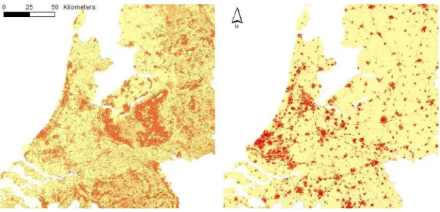
This essentially visual interpretation of openness can be demonstrated with the work of the Dutch research institute Alterra (e.g. Alphen et al. 1994; Farjon et al. 2004). In their approach, the degree of openness is based on the height of landscape elements. By using detailed geographical datasets they assess the amount of buildings and high-rising vegetation per gridcell of 250 x 250 m. Their scale ranges from a very open landscape (the typical Dutch polders) to a very closed landscape consisting of forests (see Figure 1, left-side image). Villages and cities rank in between, being classified respectively as moderately open and closed landscapes. This definition corresponds with the spatial planning perspective of open space as a crucial element of spatial quality indicators such as spatial and cultural diversity (VROM, 2000). These indicators stress the importance of a visually open landscape to preserve the contrast between rural and urban areas and to retain the cultural and historical values that are attached to it. This visual concept of openness however produces the remarkable result that extensive woodlands without much human presence are considered to be more closed than the big Dutch cities. This definition is difficult to combine with the public appreciation of the non-urban landscape that is at the heart of our valuation study.
Studies into the general appreciation of the landscape (e.g. Roos-Klein Lankhorst et al., 2002) show a positive influence of the presence of natural land use types, relief and water, whereas urbanisation, noise and visual disturbance have a negative impact on the perception of the landscape. The general public thus essentially confronts the busy, urban areas with the quiet, green countryside. As our goal is to valuate open space from a human, user-perspective we will adopt this perceptional view on open space instead of the strictly visual approach that is more common in Dutch spatial planning. Open space is thus defined as ‘being free of buildings and other proofs of human presence’ (e.g. greenhouses or infrastructure). This concept of openness corresponds roughly to the inverse of urbanisation (see Figure 1, right-side image). The least urbanised areas in this figure can be conright-sidered as open spaces. The two pictures in Figure 1 clearly show the divergent outcomes of the two alternative interpretations of open space.
A crucial element in our definition of open space is spatial scale. Green, open areas exist on different scale-levels and each has its own importance for the metropolitan citizen. We propose to distinguish three different levels:
1. the house level: small patches of open space that can be viewed from home, offering a continuous diversion from urban living conditions;
2. the local level: patches of open space within walking distance (around 300 metres) that can for example be used daily for walking the dog or as a children’s playground, and 3. the regional level: large open spaces in which residents can escape from the urban bustle
for example for outdoor activities in the weekend. To actually appreciate openness in these areas we expect a minimum dimension of 500 hectares to be relevant.
Especially the latter level of open space is under continuous threat of further urbanisation, making its valuation crucial for helping metropolitan planners to better asses the societal values of open space. The valuation of open space at lower scale levels is included in our study to give a full account of the importance of open space and furthermore serves as a reference point for the observed values at the regional level.
Additional concerns to include in the definition of regional open space include: disturbance and landscape type. With regard to the first, we will take into account the fragmentation of open landscape elements by the presence of motorways and related disturbance through traffic noise. This aspect is considered to significantly influence the human perception of open space. Other sources of disturbance, such as stench, light and visual disturbances are currently excluded from the analysis because these are either considered to be less important to the general perception of openness or are difficult to quantify objectively. As it may be expected that different land use types are valued differently, a landscape typology will be included to characterize relatively large, homogenous open areas based on common physical characteristics, history and land use.
Since legal issues (e.g. land ownership rights of the open spaces) are not directly relevant for the valuation of open space, they will not be considered in this project. Neither will the accessibility, nor the shape of the open areas be taken into account in the initial estimations. These aspects may be included however in later stages of this study.
3. METHODOLOGICAL-TECHNICAL DESIGN
An environmental-economic framework will be used to quantify the ecological, economic and societal values of open space in a coherent way. Two complementary methods will be used: revealed preference and stated preference valuation. As it will not be possible to estimate economic values for all different dimensions of open space, the research focuses on those aspects that can be related to the appreciation of individual residents of the metropolitan landscape. These are the so-called ‘use values’ that humans attach to open space on the basis of their own, direct interest. This focus means that for instance so-called ‘intrinsic’ environmental values (referring for example to habitat fragmentation and indirectly biodiversity) will be postponed for future research. Research will more specifically concentrate on the added value of the availability of open space on residential property and the valuation of cultural, natural and recreational characteristics of open space by potential visitors. The first will be studied through a revealed preference method, the latter through a stated preference method.
Revealed preference valuation studies have the advantage of potentially capturing all utilities associated with the open space and (compared to stated preference valuation) of being based on actual behaviour. An appropriate revealed preference technique for studying the issues at hand appears to be a hedonic housing prices study, which would aim to determine the
Figure 1 – The visual (left) and perceptional (right) interpretation of openness in the central part of the Netherlands. The darker colours denote an increase in closed landscape elements (left) or urban land use types (right). Figure adapted from the KELK and Land Use Scanner models (Farjon et al., 2004; Borsboom-van Beurden et al., 2005).
valuation of the availability of open space by looking at its impact on housing prices. Foreseen limitations – and hence challenges – include that it may be difficult to separate, empirically, the proximity to open space from possible associated external costs (e.g. lack of facilities), to distinguish these effects from other relevant factors that vary over space, to control for the impact of land use regulation on housing prices, and to account for heterogeneity and self-selection of individuals in their location decisions. For an adequate analysis, it is of particular importance that attention is paid to issues of spatial autocorrelation (see for example Buurman 2003; Van der Kruk 2005). Geographical Information Systems (GIS) can be used to carry out this type of geographical data-intensive analysis.
Stated preference methods offer great flexibility in the types of effects that can be valued, for instance by presenting alternatives that can be varied according to many criteria. Application of this method enables the valuation of various types of open landscape with different associated cultural, natural and aesthetic amenities from the perspective of recreational visitors. Moreover, in combination with a land use model it is possible to simulate and visualise the impact of various urbanisation strategies on the fragmentation of open space, so as to improve the respondents’ understanding of the options to be valued. A careful specification of the various alternatives to be valued allows isolation of the different components in the valuation of open space. These advantages of stated preference approaches in terms of flexibility come at a price. The most important components of which are the hypothetical character of the options and the demands posed in terms of questionnaire design.
The exact type of stated preference technique to be used on the collected data will be chosen after conducting pilot studies. In these pilots, Conjoint Analysis (CA) and Contingent Valuation Methods (CVM) will be the dominant techniques to be tested. Previous experience with these approaches can be seen for example in the work of De Blaeij (2003), Rietveld and Bruinsma (1998), and Nunes (2002). Standard discrete choice methods will be used in addition to recently developed mixed logit models.
The observed revealed and stated values of open space will be used jointly with the results from a related project - that establishes instruments for internalising landscape values in the metropolitan planning process - to evaluate the impact of the proposed instruments that will intervene on the land market. The Land Use Scanner, an integrated model that simulates future land use, will be used for simulating this impact. This model balances regional
predictions for land use change from various sector-specific models with the supply of suitable land, see for example Hilferink and Rietveld (1999) and Koomen et al. (2005). The economics-based equilibrium principle, that is at the heart of the model, mimics the land market and is therefore suited to test the effectiveness of the proposed instruments for internalizing the (economic) value of open space. In combination with new (3D) visualization techniques, interesting options for the interaction with non-expert users arise. This promising possibility will be further explored in relation to the recreational visitors that will be included in the stated preference assessment of open space value.
This paper further focuses on the revealed preference method that will be used to estimate the added value of the availability of open space in the form of a hedonic housing prices study. Both theoretical backgrounds of the employed method and empirical issues related to for example the operationalisation of the concept of open space in this specific study are discussed in the next section.
4. HEDONIC HOUSING PRICES STUDY
The location of a house is an important explanatory variable for house prices. As one of the first, Von Thünen (1826) includes location as an explanatory variable by taking transport costs into account. Based on the theoretical work of Von Thünen, Isard (1956) and Alonso (1964) developed the bid-rent theory, specifically in order to explain land prices. Alonso’s focus was on the substitution of commuting costs and house prices. Using bid-rent theory, he was able to explain that an increased distance from the Central Business District led to lower house prices and higher commuting costs. But location is only one of many characteristics of a house. The full set of house characteristics will eventually determine the price of a house. However, since all characteristics are embedded in a house, they only have an implicit value. The hedonic pricing method (HPM) was developed to compute the implicit value of all non-tradable characteristics.
According to Ethridge (2002) “[…] the earliest identified application [of the (HPM)] was by Taylor (1916) on the values of quality attributes in cotton, although the work by Waugh (1928) on vegetables is more widely recognized.” The analytical procedures used were not yet called ‘hedonic’ at that time. The first attempts to build a conceptual framework of the HPM were carried out only in the 1950s and 1960s by Theil (1952), Houthakker (1952), Lancaster (1966), and Rosen (1974). Rosen (1974) was the first to describe a generally accepted article
about this method. Almost thirty years later, Ethridge (2002) argues that “[…] economists have yet to satisfactorily merge hedonic price theory and classical price theory, although progress has been made (Hudson et al., 1998).”
The Hedonic Pricing Method determines the implicit value of non-tradable characteristics of goods by analysing the observed value of tradable goods that incorporate all or part of those non-tradable characteristics. Let A be a certain tradable good, for instance a house. The value (V(A)) of this good can be described as a function of its (non-tradable) characteristics:
V(A) = f(c1, c2, …, cn) (1)
Let good B be another house with the same characteristics as parcel A except for characteristic c1, which represents for instance the presence of open space within walking
distance (500m) of the house. Then, the value of good B can be written as:
V(B) = f(c2, c3, …, cn) (2)
It is clear that the implicit market value of the presence of open space V(c1) is the difference
between the values of the two parcels:
V(c1) = V(B) – V(A) (3)
The main strengths of the HPM are that values can be estimated based on actual choices and that (reliable) transaction data and spatial data is available. Some limitations are that the method assumes perfect competition and fully informed actors, an obvious simplification of reality where among others zoning restrictions create artificial market segments, hindering perfect competition. Also, not all actors have all information available, causing some value-affecting characteristics to stay unperceived. Actual house prices in this case will then deviate from expected, theoretical values.
Market clearing conditions to consider when applying hedonic pricing theory are (Rosen, 1974, p. 35):
- Bundles of characteristics are equally valued by buyers and sellers, equalising the observed price with the hedonic price;
- Both buyers and sellers base their location and quantity decisions on maximising behaviour, and
For a more detailed overview of advantages and limitations of the HPM, we refer to King & Mazotta (2005). For a more in-depth summary of the hedonic pricing technique, we refer to Griliches (1971, ch.1).
Selection of structural and location characteristics
Both the structural characteristics of a parcel/house and the location of a parcel/house have an impact on the market price. Structural characteristics of a house that are found to be significant in a wide range of studies are type (i.e. apartment, single-family home, villa), age, material/structure (mostly brick or wood), size (i.e. floor-area in square meters and/or volume in cubic meters), number of rooms, number of bathrooms, presence of a fireplace, presence/length/position of a garden. In the Netherlands, material/structure is considered less relevant than in the United States of America because building materials are rather uniform.
A quick-scan of recent hedonic pricing studies that include landscape characteristics in the explanation of residential property values resulted in the following list of variables related to location (see Table 1). All variables named are found to be significant in one or more studies. In particular the study done by Geoghegan et al. (1997) is interesting because it defines a set of variables that represents part of the pattern of surrounding land uses in multiple predefined radiuses around the observations. This approach is comparable to the method of including the availability of open space in our study.
Based on the reviewed studies and with our research aim and definition of open space in mind, we selected a number of characteristics for the initial estimation of our hedonic model (see Table 2). Because the focus in our research is on the relevance of spatial factors for housing prices only, we avoid time series problems by using observations from a single year: 2000. Regarding open space we differentiate the three levels that were introduced in the previous section: open space that can be viewed from the house, presence of local open space and distance to regional open space. The lower two levels are approached in a binary fashion: a variable is included to indicate whether or not this type of open space is present within 300 metres of a house. The availability of regional open space is described in four variables that allow for a distinction in proximity, size and type of the nearest open space area.
Variable Studies
Distance to city Bastian et al. (2002), and many more
Distance to/View on forest Mathis et al. (2003) 1, Turvainen and Miettinen (2000) 1, Morales (1980), Powe et al. (1995), Van Huijssteeden and Schep (1998) 2, 5
, Van Huijssteeden and Schep (1988) Distance to green (local and regional scale) Sijtsma et al. (1996) 6
Distance to local and/or regional park Bervaes (1996) 3, Fennema (1995) 3, 6, Hammer et al. (1974) 4, More et al. (1988), Van Leeuwen (1997), Weicher et al. (1973) 6 Distance to local shopping centre Mathis et al. (2003)
Distance to/Disturbance from major road Geoghegan et al. (1997), Powe, Garrod and Willis (1995) Distance to public transport station Mathis et al. (2003)
Distance to/Disturbance from school/college Powe et al. (1995)
Diversity Geoghegan et al. (1997)
Fragmentation of land uses Geoghegan et al. (1997)
Historical value of a neighbourhood/a house Mathis et al. (2003), Ruijgrok et al. (2004) 5 Natural amenities (a.o. value increase due to
the creation of new nature/recreation areas)
Geoghegan et al. (1997), Briene et al. (2001) 5, Ruijgrok, Goosen and Vonk (1999) 5, Van Huijssteeden and Schep (1988)
Noise Mathis et al. (2003), Oosterhuis and Van der Pligt (1985) 5
Open space (percentage) Geoghegan et al. (1997)
Open space (various types and distances) Ready and Abdalla (2005), Powe et al. (1995) Percentage of high voltage masts/wind mills Mathis et al. (2003)
Neighbourhood quality (measured by proxies as population composition, average income)
Geoghegan et al. (1997)
Residential land use (percentage) Geoghegan et al. (1997) Scenic view (a.o. view on or gardens
adjacent to public green/ forest/open space/ water)
Bastian et al. (2002), Garrod and Willis (1992), Geoghegan et al. (1997), Luttik and Zijlstra (1997), Mathis et al. (2003), Turvainen and Miettinen (2000)
Table 1 – Overview of location variables impacting housing prices in selected publications.
1
Only significant at <600 meter. 2
This study examines the effect of forest expansion on housing prices. 3
These studies look at both distance to and/or view on a park, at 400 meters and/or at <400 meters. 4
This study looks at distance to a park at small distance and at 800 meters. 5
Source: Ruijgrok (2004) 6
Structural characteristics
Age of house Year of study -/- building year (in years)
Type of house Different types of (single family) homes
Apartments ordered by construction time periods
Volume Measured in cubic metres
Number of rooms A choice has been made for this variable instead of Size (measured in square metres) for reasons of high correlation between the two.
Historical value Monument or not
Garden length 6 classes of garden length (ranging from 0 to >50 metres) Garden position North, East, South, West or something in between (i.e. N-E, S-W)
Locational characteristics
Ethnic composition in neighbourhood Percent of inhabitants of non-western origin.
Income in neighbourhood Percentage of earners with a low income, high income, or dependent on social security (e.g. unemployed, disabled). Distance to 100000 jobs Distance (circle radius in kilometres) within which a total of
100,000 jobs can be reached. This measure is a proxy for job opportunities in the vicinity of a house.
Distance to 100000 inhabitants Distance (circle radius in kilometres) within which a total of 100,000 inhabitants can be reached. This measure is a proxy for the level of urban facilities in the vicinity of a house.
View on open space Variable indicating whether or not a house has a view on or is situated in an open space area.
Presence of local open space Variable indicating whether or not open space is present within 300 metres
Distance to regional open space (> 500ha) Distance (in km) to nearest open space area of at least 500ha. Distance to regional open space (500 –
2500ha)
Idem for open spaces with an area of 500 – 2500ha.
Distance to regional open space (>2500ha) Idem for open spaces with an area of over 2500ha.
Type of nearest regional open space area Dominant land use of the nearest open space area; this will either be a forest, agriculture, water or other nature. A further sub-division of these categories may be considered.
Disturbance from nearest major road Variable indicating whether or not a location is within a 250m zone of a major road, signifying the presence of disamenities as noise or air pollution.
Distance to nearest highway entry/exit Distance to nearest highway-exit (in kms) indicating accessibility. Distance to nearest public transport station Dist. to train or metro station as a measure for accessibility
Case study selection
The Dutch Randstad area is an interesting mix of urban and open areas and thus makes a natural case study area for our study. This area in the west of the country has the highest population density and economic pressure nationwide. Urban growth seriously threatens the remaining open space here.
The Randstad area has around 7 million people (GEMACA, 2002) and can certainly not be considered a single homogenous housing market. Separate, smaller case study areas must therefore be selected for the analysis. This is done because “[…] the market for a hedonic analysis […] should contain all the options
available to potential buyers. If the market is defined larger than individuals actually choose from, then the regression results will be biased. On the other hand, by limiting the size of the market, the investigator loses information, so the estimation may become less efficient.” (Geoghegan et al. 1997, p.258). For the Netherlands, the Dutch Association of Real estate brokers and real estate experts (NVM) distinguishes 80 homogeneous local housing market areas.
For the initial estimation of the model, the area around the city of Leiden is selected. This city in the western part of the Randstad is situated near The Hague and has around 120,000 inhabitants (CBS, 2005). The city has a number of open spaces in its surroundings: dunes and forest in the west, lakes to the north and the grasslands of the Green Heart to the east.
Data collection and preparation
We will be using a database with housing prices and structural characteristics of the sold objects. This database will be provided by NVM. All individual objects will be given a geographical location (X- and Y-coordinates) based on the address-information. This geo-coding will be done on the highest possible level of detail. Additional information on location characteristics (e.g. distance to major roads) is obtained from basic GIS-calculations.
Figure 2 – Location of the selected housing market (NVM) region of Leiden within the Dutch Randstad urban constellation.
To make our definition of open space (Section 2) operational we use a raster GIS with a detailed 25 meter grid land use map (CBS, 2002). This dataset allows for the selection of open land use (all agriculture except greenhouses, nature and/or recreation) at the three selected spatial scale-levels:
1. view on open space will assessed by retrieving the land use at the location of the sold object. All objects within, or directly adjacent to a gridcell containing an open land use type are considered to have a view on open space. Especially for the inner-city areas this approach has the disadvantage of missing very small patches of green1 and of not being able to exactly match the actual view from individual houses. We will however use this method because more detailed datasets are not available.
2. the presence of local open space will be inferred from the availability of any size of open space within 300 metres from the sold object.
3. regional open space is defined as being a region of adjacent gridcells containing open land use types with a minimum size of 500 ha. A data layer with the national motorway system is overlaid on the open space cells to pinpoint the locations that are disturbed by the presence of the motorways. In a following step contiguous regions of open space are defined by automatically retrieving interconnected cells that are classified as being open and not disturbed by motorway traffic. The resulting areas of open space are then combined with a landscape-types dataset to distinguish homogenous open areas that can be characterised in terms of size and dominant land use.
5. CONCLUSIONS
This study aims to quantify the non-economic value of open space that is relevant to spatial policy, making these values easier to consider in policy-making. Two complementary valuation methods will be applied: a hedonic pricing method to assess the impact of open space on residential property values and a stated preference approach to establish the value of open space for recreational purposes. This paper introduces the research framework that includes a conceptualisation of open space. Openness is in our approach interpreted as being the opposite of urbanisation. For this study we distinguish open spaces on three spatial scales: 1) open spaces that are visible from home, 2) local level open spaces and 3) regional level
1
open spaces. The latter level is especially important for metropolitan planning and its definition includes: land use, disturbance by motorway traffic, landscape typology and size. Based on a literature review of recent hedonic pricing studies that include landscape characteristics we designed our own hedonic housing prices study for the valuation of metropolitan open space. After operationalising the three conceptual levels of open space in GIS and collecting the relevant data on house prices we are now able to start estimating the value of open space. The first preliminary estimation results will be presented at the ERSA2005 conference.
Acknowledgements
We like to thank the Netherlands Environmental Assessment Agency (MNP) for allowing us to use spatial data for this research project.
REFERENCES
Alonso, W. (1964), Location and land use, Harvard University Press, Cambridge.
Alphen, B.J. van, H. Dijkstra & J Roos-Klein Lankhorst (1994), De ontwikkeling van een methode voor monitoring van de maat van de ruimte. Report no. 334, onderzoekreeks Nota Landschap, no. 2, DLO-Staring Centrum, Wageningen.
Bastian, C.T., D.M. McLeod, M.J. Germoni, W.A. Reiners and B.J. Blasko (2002), Environmental amenities and agricultural land values: a hedonic model using geographic information systems data, Ecological Economics, vol.40, pp: 337-49.
Borsboom-van Beurden, J.A.M., W. T. Boersma, A.A. Bouwman, L.E.M. Crommentuijn, J.E.C. Dekkers & E. Koomen (2005), Ruimtelijke Beelden, Visualisatie van een veranderend Nederland, RIVM report 550016003/2005, MNP-RIVM, Bilthoven.
Briene, M.F.M., I.J. Boeckhout, A.F.M. Verschuren, A.C.P. Verster and J.A. Annema (2001), Kosten en baten 750 ha natuur- en recreatiegebied regio Rotterdam, NEI/RIVM, Rotterdam/Bilthoven.
Button (1993), Transport, the environment and economic policy, Edward Elgar, Aldershot.
Buurman, J.J.G. (2003), Rural land prices, a spatial explanatory model, RIVM report 718301001/Ph.D. Thesis, Vrije Universiteit, Amsterdam.
CBS (2002), Productbeschrijving bestand Bodemgebruik, Centraal Bureau voor de Statistiek, Voorburg/Heerlen.
CBS (2005), StatLine, Centraal Bureau voor de Statistiek, www.statline.nl, last visited: June 15, 2005.
De Blaeij, A. (2003), The Value of a Statistical Life in Road Safety, Ph.D. thesis, Vrije Universiteit Amsterdam.
Ethridge, D.E. (2002), Daily Hedonic Price Analysis: An Application to Regional Cotton Price Reporting. Proceedings, Price Indices and the Measurement of Quality Change, Conference sponsored by the Center for European Economic Research, University of Mannheim, Mannheim, Germany, April 25-26.
Farjon, J.M.J., J. Roos-Klein Lankhorst & P.J.F.M. Verweij (2004), KELK 2003 – landschapsmodule; Kennismodel voor de bepaling van Effecten van ruimtegebruiksverandering op de Landschappelijke kwaliteit. NPB-Werkdocument 2004/10, RIVM/Alterra/LEI, Bilthoven/Wageningen/Den Haag.
Fennema, A.T. (1995), Wonen in het groen; de invloed van groen op de prijs van een woning, DLO-Staring Centrum, Wageningen.
Friedrich, R. and P. Bickel (2002) Environmental External Costs of Transport, Springer Verlag, Berlin.
Fujita, M. (1989), Urban economic theory: land use and city size, Cambridge University Press, Cambridge.
Garrod, G. and K. Willis (1992), The environmental economic impact of woodland: A 2-Stage hedonic price model of the amenity value of forestry in Britain, Applied Econ., vol. 24, no7, pp: 715-28.
GEMACA (2002), The metropolises of North-West Europe in figures, Group for European Metropolitan Areas Comparative Analysis-IAURIF, Paris.
Geoghegan, J., L.A. Wainger and N.E. Bockstael (1997), Spatial landscape indices in a hedonic framework: an ecological economics analysis using GIS, Ecological Economics, vol.23, pp: 251-64.
Griliches, Z. (1971), Introduction: Hedonic Price Indexes Revisited. In: Price Indexes And Quality Changes: Studies In New Methods Of Measurement (Ed.) Z. Griliches, Cambridge, pp. 3-15.
Hammer, T.R., R.E. Coughlin, and E.T. Horn (1974). The effect of a large urban park on real estate, J. Amer. Inst. Planning, vol. 40, no.4, pp: 274-77.
Hilferink and Rietveld (1999), Land Use Scanner: an integrated GIS-based model for long term projections of land use in urban and rural areas, Journal of Geographical Systems, vol. 1, no. 2, pp: 155-77.
Houthakker, H.S. (1952), Compensated Changes in Quantities, and Qualities Consumed. Review of Econ. Studies, vol. 3, pp: 155-64.
Hudson, D., D. Ethridge, and E. Segarra (1998), Incorrect Price Information for a Heterogeneous Commodity: A Conceptual Analysis, Review of Agricultural Economics, vol. 20, No. 2, Fall/Winter, pp: 365-76.
Isard, W. (1956) Location and space-economy. The M.I.T. Press, Cambridge.
King, D.M. and M. Mazotta (2005), Ecosystem valuation, Universities of Maryland/University of Rhode Island, www.ecosystemvaluation.org, last visited: June 8, 2005.
Koomen, E., T. Kuhlman, J. Groen & A. Bouwman (2005), Simulating the future of agricultural land use in the Netherlands, Tijdschrift voor Economische en Sociale Geografie, vol. 96, no. 2, pp: 218-24.
Lancaster, K. J. (1966), A New Approach to Consumer Theory, Journal of Political Eonomy, vol. 74, pp: 132-57.
LNV (2002), Structuurschema Groene Ruimte 2, samen werken aan groen Nederland, Ministerie van Landbouw, Natuurbeheer en Visserij.
Luttik, J. and M. Zijlstra (1997), Woongenot heeft een prijs. Het waardeverhogend effect van een groene en waterrijke omgeving op de huizenprijs, Report no. 562, DLO-Staring Centrum, Wageningen.
Mackie, P. and J. Nellthorp (2001) “Cost-Benefit Analysis in Transport”. In D.A. Hensher and K.J. Button (eds.) (2001) Handbook of Transport Systems and Traffic Control, Handbooks in Transport 3 Elsevier / Pergamon, Amsterdam, pp: 143-74.
Mathis et al. (2003), Valuing Nature: A Survey of the Non-Market Valuation Literature, Discussion paper VNT03-01, Houston Advanced Research Center, USA.
Morales, D. J. (1980), The Contribution of Trees to Residential Property Value, Journal of Arboriculture 6, pp: 305-08.
More, T.A., T. Stevens and P. Allen (1988), Valuation of urban parks, USDA Forest Service, Landscape and Urban Planning, vol. 15, pp: 139-52.
Muth, R. F. (1969) Cities and Housing: The Spatial Pattern of Urban Residential Land Use, University of Chicago Press, Chicago.
Nunes, P.A.L.D. (2002), The contingent valuation of natural parks: assessing the warmglow propensity factor, Edward Elgar, Cheltenham.
Oosterhuis, F.H. and Van der Pligt (1985), Kosten en baten van de wet geluidshinder, S.l.: s.n.
Powe, N.A., G.D. Garrod and K.G. Willis (1995), Valuation of urban amenities using an hedonic price model, Journal of Property Research, vol. 12, pp: 137-47.
Ready, R.C. and C.W. Abdalla (2005), The amenity and Disamenity Impacts of Agriculture: Esitmates from a Hedonic Pricing Model, American Journal of Agricultural Economics, vol.87, no. 2, pp: 314-26.
Rietveld, P. & F. Bruinsma (1998), Is transport infrastructure effective? Springer, Berlin.
Rosen, S. (1974), Hedonic prices and implicit markets: product differentiation in pure competition, Journal of Political Economy, vol. 82, no. 1, pp: 34-55.
Ruijgrok, E.C.M. (2004), Valuation of Nature and Environment. A historic overview of Dutch socio-economic valuation studies, Platform for Economic Valuation of Nature, Rotterdam.
Ruijgrok, E.C.M., E.E.M. Nillesen and R.E. Atman (2004), Economische waardering van cultuurhistorie. Een case-studie in de Tieler- en Culemborgerwaard, Projectbureau Belvedere, Utrecht.
Taylor, F. (1916), Relation between Primary Market Prices and Qualities of Cotton., U.S. Department of Agriculture, Bulletin no. 457, Nov. 24.
Ruijgrok, E.C.M., H. Goosen and S. Vonk (1999), Meervoudig ruimtegebruik en natuurwaarden; Een studie naar de ecologische- en belevingswaarden van multifunctionele natuurtypen, Stichting LWI, Gouda.
Sijtsma, F.J., T.M. Stelder, J.P. Elhorst, J. Oosterhaven and D. Strijker (1996), Ruimte over, ruimte tekort, Stichting Ruimtelijke Economie, Groningen.
Theil, H. (1951), Qualities, Prices, and Budget Inquiries, Review of Econ. Studies, vol. 19., pp:129-47.
Turvainen, L. and A, Miettinen (2000), Property Prices and Urban Forest Amenities, Journal of Environmental Economics and Management, vol. 39, pp: 205-23.
Van Huijssteeden, R. and P.J. Schep (1998), Verkenning indirecte economische effecten van bosuitbreiding in de randstad, Rijksinstituut voor onderzoek in de bos- en landschapsbouw, Wageningen.
Van Huijssteeden, R. and P.J. Schep (1988), Verkenning indirecte economische effecten van bosuitbreidingen in de Randstad, report no. 515, de Dorschkamp, Wageningen.
Van der Kruk, R. (2005), Economic valuation of wetlands, Ph.D. Thesis, Vrije Universiteit Amsterdam.
Van Leeuwen, M.G.A. (1997), De meerwaarde van groen voor wonen; een regionale analyse, report no. 576, Landbouw-Economisch Instituut (LEI-DLO), Den Haag.
Von Thünen, J.H. (1826), Der isolierte Staat, in Beziehung auf Landwirtschaft und Nationalökonomie, Neudruck nach der Ausgabe letzter Hand (1842), Gustav Fisher Verlag, Stuttgart, 1966.
VROM (2000), Balans ruimtelijke kwaliteit 2000, Ministerie van Volkshuisvesting Ruimtelijke Ordening en Milieubeheer, Den Haag.
VROM/LNV/V&W/EZ (2004) Nota Ruimte. Ruimte voor ontwikkeling, Ministeries van Volkshuisvesting, Ruimtelijke Ordening en Milieubeheer, Landbouw, Natuur en Voedselkwaliteit, Verkeer en Waterstaat en Economische zaken, SDU uitgeverij, Den Haag.
Waugh, F. (1928), “Quality Factors Influencing Vegetable Prices.” J. Farm Econ., vol. 10, pp: 185-96.
Weicher J.C. and R.H. Zerbst (1973), The externalities of neighbourhood parks : an empirical investigation, Land Economics, vol. 49, pp: 99-105.