http://dx.doi.org/10.4236/eng.2015.73012
Real-Time Monitoring of Climactic and
Geotechnical Variables during Landslides
on the Slopes of Serra do Mar and Serra da
Mantiqueira (São Paulo State, Brazil)
Rodolfo Moreda Mendes1, Mário Valério Filho2
1National Center for Monitoring and Warning of Natural Disasters-CEMADEN, São José dos Campos, Brazil 2IP & D, Vale do Paraíba University, São José dos Campos, Brazil
Email: rodolfo.mendes@cemaden.gov.br, mvalerio@univap.br
Received 19 September 2014; accepted 24 March 2015; published 26 March 2015
Copyright © 2015 by authors and Scientific Research Publishing Inc.
This work is licensed under the Creative Commons Attribution International License (CC BY). http://creativecommons.org/licenses/by/4.0/
Abstract
The municipalities of Ubatuba, Campos do Jordão, and São José dos Campos are located in the re-gion of São Paulo State (Brazil). These municipalities are recognized nationally for having an ele-vated number of recorded landslides on slopes and embankments. In addition, these municipali-ties contain multiple areas that are at risk for landslides. Various soil landslides occurred in these municipalities in January 2013, when real-time climactic and geotechnical variables were moni-tored by automatic rain gauges, humidity sensors and soil temperature and suction devices. The resulting data were used to understand the functions of each variable in the occurrence of land- slides. Analyses of rainfall, humidity and soil temperature were used with field investigations to formulate a hypothesis regarding the predominant rupture mechanism and the role of each mo-nitored variable in the deflagration of the soil landslides that occurred in the three studied muni-cipalities. The geotechnical variable data revealed that both temperature and soil moisture con-tents played fundamental roles in the deflagration of shallow planar landslides in urban areas. The hourly rain intensity and/or rainfall accumulation for 24 and/or 72 h were responsible for the deflagration of the landslides that occurred in the studied areas, along with the existing anth-ropic constraints in the risk areas. Significant variations did not occur in the soil suction data during the landslides, principally due to the unsatisfactory sensor precision when reading field suction between −10 and −100 kPA (±25%).
Keywords
1. Introduction
Geologic risks in São Paulo State (Brazil) have been highlighted nationally and internationally, mainly due to the elevated number of landslides that have occurred on urban slopes and the number of municipalities with areas of landslide risk. Several municipalities that are located in regions with elevated landslide susceptibility are notable [1]. For example, the municipalities with urban areas on the slopes of the Serra da Mantiqueira (Campos do Jordão and São José dos Campos) and Serra do Mar (Ubatuba). The susceptibility of these areas to landslides has been corroborated by the significant number of landslides that have been registered by the Geo-logical Institute of São Paulo State (Figure 1) in the framework of the Preventative Plan of Civil Defense (PPDC).
The identification, evaluation and management of landslide risk areas in São Paulo State (Brazil) began fol-lowing large scale accidents with grave consequences that occurred during the summer of 1987/1988 in the re-gion of Serra do Mar. Consequently, the state government decided to implement the PPDC, which was specific for landslides on the slopes of the Serra do Mar in Sao Paulo State. The main objective of the PPDC is to avoid human death by relocating populations that occupy risk areas before a landslide occurs. However, to prevent death from landslides, the actions of the PPDC are based on the daily monitoring of critical rainfall levels (rain accumulated in 72 h) and the meteorological forecasts for each municipality. The critical rainfall levels used in the preventative removal action of populations from risk areas were defined based on a correlative study be-tween rainfall and landslides that was initially designed for the municipality of Cubatão, São Paulo State [2] [3]. The correlation results obtained in [2] [3] for the municipality of Cubatão were posteriorly extrapolated for the remaining municipalities of São Paulo State by using the 72-h accumulated rainfall data as a reference. With this method, different values of critical rain accumulation were established for the municipalities using the PPDC. These values highlighted the 72-h rainfall accumulations in the following regions: Serra do Mar (Ubatuba)—120 mm; Vale do Paraiba (São José dos Campos)—100 mm and Serra da Mantiqueira (Campos do Jordão)—80 mm.
[image:2.595.130.500.401.692.2]A significant number of national and international studies were observed to establish correlations between
rainfall and gravitational mass movements. Among these international studies, developments in [4]-[20] are notable. In Brazil, the studies of [2] [3] [21]-[31] are noteworthy.
However, the spatial distribution of rainfall in a particular region is not homogeneous and tends to be less correlated with landslides when rain gauges are farther apart, especially when convective rainfall occurs in Bra-zil during the summer season, which generally has high spatial variability [32]. Therefore, the extrapolation of rainfall data points that represent a given area where landslides have occurred represents critical rainfall values in other regions that may contain inadmissible uncertainties for the operation of the PPDC. In addition, the criti-cal rainfall rates used in certain areas cannot satisfactorily represent the criticriti-cal rainfall conditions that are ne-cessary for the deflagration of landslides in other regions that have different geological and geotechnical cha-racteristics. This disconnect was recently observed by analyzing rainfall and landslide data within the PPDC that were recorded over 10 years [33]. Overall, this finding highlights the importance of monitoring parameters that are related to the geological and geotechnical characteristics of each region or risk area to understand the rupture mechanisms of landslides in urban areas, especially those parameters that permit infiltration and rainwater reten-tion assessments.
Studies of climate and geotechnical variables on slopes in the Serra do Mar, specifically on the northern coast of São Paulo (Brazil), have been conducted by Brazilian researchers since 2005. These studies have contributed to understanding the effects of seasonal rainfall variations on the suction and humidity profiles of non-saturated residual soils [34]-[38]. Moreover, these studies have contributed to the use of sensors and non-invasive me-thods for assessing the suction profiles and moisture contents of tropical residual soils [38]-[43].
In Brazil, the climate and peculiar characteristics of tropical residual soils have generated the need for specific studies that combine climactic variables and soil geotechnical properties to understand the hydro-mechanical behavior of the soil and the relationships between climate and the geotechnical variables that trigger landslides in such soils.
Residual soil landslides are often associated with the rainy season on Brazilian slopes. According to [44], the main geotechnical variable for the occurrence of landslides is the reduction or elimination of shear soil strength that results from rainwater infiltration in the soil profile. For landslides in tropical residual soils, it is important to study the seasonal variations of matrix suction and moisture content within the soil profile that result from pe-riods of rain and drought. Thus, it is important to evaluate the influence of rainfall on the hydro-mechanical be-havior of the soil by monitoring climactic aspects and their effects on the matrix suction and moisture contents of the soil profile. Therefore, this paper presents new real-time monitoring results from geotechnical and climac-tic variables that are obtained by installing automaclimac-tic rain gauges and sensors. These sensors measured total rainfall, suction, temperature and soil moisture in the municipalities of Campos do Jordão, São José dos Campos and Ubatuba, São Paulo State (Brazil), where several landslides occurred in risk areas during the in situ moni-toring period.
2. Study Areas
2.1. Selection and Location
The initial criteria for selecting the study areas for implementing the field trials considered the following region-al aspects of the physicregion-al and urban environment of each municipregion-ality: 1) distinct regionregion-al climate variations (in terms of rainfall distribution), 2) regional aspects of relief and 3) the presence of landslide risk areas. In addition, the following conditions were used to choose the study areas: 1) areas with high and/or very high risk levels for landslides, 2) areas with safe areas for equipment installation and monitoring and 3) areas with adequate mobile phone signal to enable data transmission via GSM/GPRS technology.
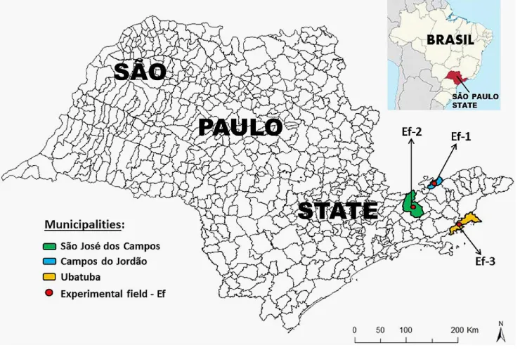
The selected study areas are located in municipalities with individual climate features that are based on re-gional climates and reliefs (according to Martinelli 2010: Faixa Costeira (Ubatuba), Porção Lestedo Planalto Atlântico (Campos do Jordão), and Vale do Paraíba (São José dos Campos). The locations of the experimental plots in the municipalities of Campos do Jordão (Ef-1), São José dos Campos (Ef-2) and Ubatuba (Ef-3) are shown in Figure 2.
si-tuated, is between 1200 and 1400 mm (Table 1).
2.2. Geological and Geotechnical Characterization
The geological and geotechnical characterization of each experimental region was initially performed in the field by observing the soil profiles that were considered the most critical (exhibiting greater natural susceptibili-ty to landslides). These areas represented landslide risk areas (dashed yellow line) in the municipalities of Cam-pos do Jordão (Ef-1), São José dos CamCam-pos (Ef-2) and Ubatuba (Ef-3) (Figure 3). Briefly, the following region-al and locregion-al geologicregion-al features of each experimentregion-al field were obtained:
Campos do Jordão (Ef-1)—Metamorphic rocks, such as migmatites, gneisses, metadioritic and granu-lites dominate the region. In addition, schists, quartzites and metaconglomerates occur as lenses with some mag- matic intrusions [46]. Migmatitic rocks occur locally with alternating bands of neosome (granite) and paleosome (gneiss), with thicknesses that range from a few meters (in the case of granite) to centimeters (in the case of gneisses) thick [47] [48].
[image:4.595.130.500.273.522.2] São José dos Campos (Ef-2)—The study area is regionally inserted into the tectonic compartment
Figure 2.Localization of the municipalities in the São Paulo State (Campos do Jordão, São José dos Campos e Ubatuba) where were implanted the experimental fields (Ef-1, Ef-2 e Ef-3), respectively.
Table 1.Minimum, maximum and average rainfall annual values of the studied areas.
Municipalities
Rainfall average annual (mm) Period Rain gauge localization Altitude
Minimum Maximum Average (Year) Latitude Longitude (Meters)
São José dos Campos
917 2.055 1.289 1943 to 2003 23˚11'S 45˚53'W 560
887 2.271 1.396 1943 to 2000 23˚03'S 45˚54'W 570
Campos do Jordão
1.035 4.457 1.801 1937 to 2004 22˚43'S 45˚34'W 1590
1.342 2.786 1.778 1973 to 2001 22˚42'S 45˚29'W 1620
Ubatuba
1.777 4.374 3.057 1957 to 2004 23˚23'S 45˚07'W 142
1.414 3.977 2.399 1945 to 2000 23˚23'S 44˚50'W 184
[image:4.595.89.541.572.710.2]Figure 3.Localization of the experimental fields implanted in the landslides risk areas in the municipalities of Cam-pos do Jordão (Ef-1), São José dos CamCam-pos (Ef-2) e Ubatuba (Ef-3).
named the Southeast Regional Fold with rocks of the Embu Complex (paragneiss units and banded gneiss) that are composed of phyllites, schists, gneisses and migmatites. Locally rocks consisting of gneisses and migmatites are dominant without the marked occurrence of lithological variations [49].
Geotechnical characterization began with the identification of representative soil profiles in the experimental fields Ef-1, Ef-2 and Ef-3. These profiles had the following soil horizons: 1) Horizon “H1”, topsoil resulting from pedogenesis with a thickness of 0.7 to 1.0 m; 2) Horizon “H2”, the mature residual soil (no matrix rock structure and relatively homogeneous) with a thickness of 2.5 to 4.0 m; and 3) Horizon “H3”, young residual soil or saprolites resulting from a rocky basement with the original matrix rock structure and a thickness of 5 to 15 m.
The thickness variations of the soil horizons were directly related to the position of the slope profile and its morphology, with greater depths at end regions and shallower portions at the bases of the slopes. The water table was considerably deeper on the slopes where experimental fields were planted and where upwelling or resur-gences of water were not observed during field investigations. In Figure 4, schematic soil profiles of the three experimental fields are presented. These profiles were determined at the locations where the climactic and geo-technical monitoring systems were implemented.
After identifying the soil profiles of each experimental site, representative samples of each soil horizon (H1, H2 and H3) were collected for geotechnical characterization according to the Brazilian Technical Standards (ABNT). The geotechnical characterizations of sieve analysis, soil grain density, natural density and the Atter-berg limits (liquid and plastic limits) were performed with deformed samples that were collected in the study sites of Campos do Jordão, São José dos Campos and Ubatuba. The overall results of the geotechnical characte-rization tests are shown in Table 2.
2.3. Landslides Characteristics in the Study Areas
Landslides in regions with the soils that often occur in the Serra do Mar and Serra da Mantiqueira (where the experimental sites are located) are usually associated with the rainy season [52]. Soil landslides, especially those of translational or planar shallow soils, occur naturally in middle and high slopes with rugged reliefs, even if the slopes are free of human influence.
[image:6.595.107.519.453.687.2]The primary mechanism of slope destabilization is the reduction or elimination of “apparent” soil cohesion, which results from the infiltration of rainwater through the soil profile [22] [52] [53]. Because this type of des-tabilization is the dominant form of instability in the studied areas, it is important to monitor soil water infiltra- tion and retention (rainfall, moisture content, suction and temperature) continuously to understand the function of each variable in this type of instability mechanism.
Table 2.Geotechnical characterization of the Ef-1, Ef-2 and Ef-3 experimental field.
Municipalities/ experimental
field
Localization Sample/ layer in soil profile
Depth sample
(m)
Grain size (%) Atterberg limits
γs γ
Sand Silt Clay
wL wP IP
Long. Lat. (%) (%) (%) USCS (kN/m3) (kN/m3)
Campos do
Jordão (Ef-1) 45˚36'W 22˚44'S
CJ-H1 0.3 54 19 27 25 NP NP ML 29.6 13.1
CJ-H2 3.0 42 14 44 31 29 2 ML 23.5 16.2
CJ-H3 6.0 67 26 7 24 21 3 SM 27.0 13.8
São José dos
Campos (Ef-2) 45˚54'W 23˚09'S
SJC-H1 0.5 56 18 26 29 NP NP SM 26.8 15.0
SJC-H2 3.0 36 8 56 27 20 7 CL-ML 26.6 14.4
SJC-H3 6.5 57 34 9 27 24 3 SM 26.9 15.7
Ubatuba (Ef-3) 45˚06'W 23˚26'S
UBA-H1 0.4 53 16 31 50 37 13 MH-ML 27.1 17.4
UBA-H2 1.5 41 13 46 48 23 25 CL 26.3 16.5
UBA-H3 7.0 54 20 26 45 26 19 CL 26.7 15.2
In general, the major natural constraints that are responsible for translational landslides in the study areas in-clude high slope steepness (generally larger than 30˚), which is associated with morphology (concave and/or li-near geometry), and the presence of seasonal “apparent” cohesion, which results from an unsaturated soil profile and high rainfall (cumulative and/or hourly rainfall intensity). In addition, human action in these locations, such as slope cuts and/or dumped fills, overloading the land and the release of wastewater and/or leaking pipes on the slopes, significantly increases the geotechnical instability.
The landslides recorded in the Campos do Jordão (Ef-1) and São José dos Campos (Ef-2) study areas were planar or shallow translational (depth of rupture < 2.0 m) and occurred in urban areas. In this case, the three (03) following predominant rupture mechanisms were observed (Figure 5): A—surface rupture in the layer of resi-dual soil slope H1; B—surface rupture in the resiresi-dual soil layer H2 or H1 cut slope; and C—surface rupture at the base of the created fill or at the slope of the residual soil layer of H1 (with mobilization of the overlying dumped fill). Generally, the type “C” rupture mechanism moves greater amounts of material, which reach a larger number of homes and cause serious damage. The failure mechanisms of landslides that occurred in the city of Campos do Jordão between 01/11/2013 and 01/13/2013 are presented in Figure 5 (A, B, or C). Figure 6 shows the locations of the eight (08) landslides that occurred in the city of Campos do Jordão near the experi-mental field (Ef-1) between 01/11/2013 and 01/13/2013 (blue dots). In addition, Figure 6 shows eighteen (18) landslides that were recorded in 2000 (red polygons on map).
Landslides that occurred in the city of São José dos Campos between 01/10/2013 and 01/11/2013 are pre-sented in Figure 7. Figure 8 shows the locations of the two (02) landslides that occurred in the city of São José dos Campos near the experimental site (Ef-2) between 01/10/2013 and 01/11/2013 (blue dots). In addition, Fig. 8 shows the 61 landslides that were recorded between 2009 and 2013 (Figure 8, A).
The landslides that occurred near the experimental monitoring site of Campos do Jordão (Ef-1) and São José dos Campos (Ef-2) were affected by anthropic components, including instability factors. These factors included the implementation of slope cuts and dump fills, the discharge of wastewater and rainwater on slopes and/or slope cuts/landfills and the discharge of leaking pipes on slope or slope cuts/landfills. Consequently, rainfall, depending on its hourly intensity or total accumulation over 24, 48 or 72 h, was responsible for the outbreak of occasional landslides in these urban areas.
Figure 5.(I) Characteristics and main failure mechanisms of landslides in the study areas; (II) Landslides oc-curred in Campos do Jordão in the year 2000 [48]; (III), (IV), (V) and (VI) landslides of the types B, C (H1), C (dumped fill) and A, respectively, occurred in Campos do Jordão between 01/11/2013 and 01/13/2013 (Source: Geological Institute).
heavy rain from January 3 to 4, 2013, based on the accumulated precipitation data that were recorded by the au-tomatic environmental station of Picinguaba (near the landslide) (Figure 10).
Overall, three landslides occurred in Ubatuba between 01/03/2013 and 01/04/2013 (Figure 10; yellow dots 1, 2 and 3). These landslides occurred on natural, un-developed slopes. However, some type of intervention oc-curred at the base of the slopes (work projects cut/dumped fills for construction of highway BR 101).
During these events in Ubatuba, the automatic environmental station (AES/INPE) near the three landslide points (yellow dots 1, 2 and 3) recorded the following information between 01/03/2013 and 01/04/2013: 125.0 accumulated rainfall in 24 h, mean soil temperature of 28.5˚C and a volumetric moisture content of 0.45 m3
/m3 (Figure 10). Despite the considerable distance between the AES/INPE and the experimental field monitoring station of Ubatuba (Ef-3), very similar soil temperature (28˚C) and moisture (0.46 m3
[image:8.595.110.519.80.533.2]Figure 6.Landslides occurred in Campos do Jordão in the year 2000 (red polygons on map, [48]) and landslides occurred in Campos do Jordão between 01/11/2013 and 01/13/2013 (blue dots, source: Geological Institute), the numbers II, III, IV, V and VI refer to the landslides presented in Figure 5.
Figure 7.(VII) and (VIII) landslides of the type C (dumped fill) and B, respectively, occurred in São José dos Campos between 01/10/2013 and 01/11/2013 (Sources: VII, authors and VIII, Civil Defense of São José dos Campos).
[image:9.595.176.449.492.673.2]Figure 9.Reactivation of landslide on the slope of Serra do Mar (yellow dot 2 in
Figure 10), occurred in Ubatuba between 01/03/2013 and 01/04/2013 in the km 14 of the highway BR-101 (Source: Geological Institute).
significantly different (40.0 mm).
In general, the anthropic activities interfered with the landslide rupture mechanisms in the studied urban areas, especially for slope cuts and dumped fill materials, regarding the amounts of hourly or daily rainfall needed to promote landslides. Thus, human interventions in densely populated risk areas significantly reduce the amount of rain that is required to generate landslides relative to other areas with low levels of human occupation and in-tervention.
3. Experimental Site Implementation
3.1. In Situ Monitoring Sensor Installation
Figure 10. Localization of the landslides occurred in Ubatuba between 01/03/2013 and 01/04/2013 (yellow dots 1, 2, e 3, [54]), the yellow dot 2 refer to the landslide presented in Figure 9; the data of temperature and moisture of the soil represent the average values of the soil profile up 0.50 meter deep [55].
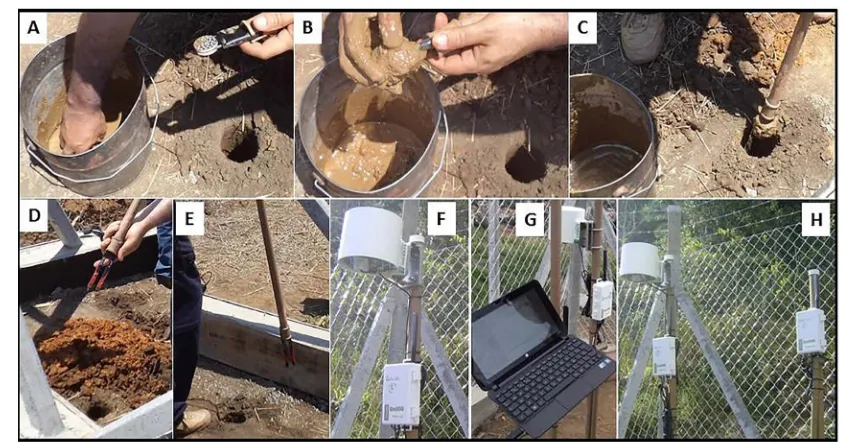
in the Campos do Jordão (Ef-1), São José dos Campos (Ef-2) and Ubatuba (Ef-3) fields as shown in Figure 4. To install sensors and other equipment that make up the “Monitoring System of the Experimental Plots”, the in-stallation recommendations of the manufacturer (Decagon Devices) were followed. Briefly, the following pro-cedures were used. 1) Soil suction and temperature sensor (MPS-2 dielectric potential sensor). Initially, an au-ger was used to make a hole that was of the depth of the sensor installation depth. Next, the sensor was placed in the “installation system” and wrapped in a moist mass of the same soil that was removed from the bottom of the hole. Finally, the sensor was inserted into the hole to its base (steps A/B/C of Figure 11). 2) Soil moisture sen-sor (10HS soil moisture). Initially, an auger was used to make a hole that was the depth of the sensen-sor installation depth. Next, the sensor was inserted directly into the hole to its base. In this case, the “installation system” that was developed specifically for this project (steps D/E Figure 11) was used. 3) Rain gauge and automatic data acquisition and transmission system (Em50G collect automatic system date). The rainfall gauge (rainfall) and the automatic data acquisition and transmission devices were installed directly in two rigid PVC tubes before directly connecting the rainfall sensor, soil moisture and suction cables to the data acquisition system. The data acquisition system consisted of two data loggers with five channels each (steps F/G/H of Figure 11).
3.2. Analysis of the Monitored Data from the Experimental Plots
[image:11.595.113.515.86.392.2]Figure 11.Installation of in situ monitoring sensors (A/B/C, soil suction and temperature sensors; D/E, soil moisture sensor), automatic data acquisition systems and rain gauges (F/G/H, rain sensor with data loggers with data transmission via the Global System for Mobile Communications, GSM/GPRS cellular technology).
0.3 m 0.6 m 1.0 m 1.5 m 2.0 m
(a)
0.3 m 1.0 m 2.0 m
(c)
Figure 12. Monitoring data from the precipitation, soil temperature and soil moisture sensors in the experimental plot of Campos do Jordão (Ef-1) from 12/01/2012 to 12/01/2013, the main period of observed landslides (01/11/2013 to 01/12/2013, indicated by black arrows).
0.3 m 0.6 m 1.0 m 2.0 m 3.0 m
(a)
0.6 m 1.5 m 3.0 m
(c)
Figure 13. Monitoring data from the precipitation, soil temperature and soil moisture sensors in the experimental plot of São José dos Campos (Ef-2) from 12/01/2012 to 12/01/2013, the main period of observed landslides (01/10/2013 to 01/11/2013, indicated by black arrows).
systems in the three experimental fields are presented (Ef-1, Ef-2 and Ef-3) for the period between 12/01/2012 and 12/01/2013. Along with the climatic and geotechnical data that were recorded during the period, Figures 12-14 show the most probable regions of landslide outbreaks that were recorded during the study period (black arrows). These landslide regions included 1) the Campos do Jordão, 08 landslides (beginning on 01/11/2013); 2) the São José dos Campos, 02 landslides (beginning on 01/10/2013) and 3) the Ubatuba, 03 landslides (beginning on 01/04/2013).
The climatic and geotechnical data that were recorded by the monitoring systems of the experimental field of Campos do Jordão (Ef-1) are shown in Figure 12. Here, the initial day (01/11/2013) of the 08 landslides rec-orded in the county during operation of the PPDC are indicated. By considering the rainfall data for the entire study period (Figure 12), the greatest rainfall concentration occurred between 12/01/12 and 04/30/13 (totaling 1832 mm of precipitation). This rainfall accounted for approximately 80% of the total rainfall that was recorded throughout the entire monitoring period (2334 mm), with a maximum rainfall intensity of approximately 30.0 mm/10 minutes on 02/15/13. When considering the early landslides on 01/11/13, the monitoring system of Campos do Jordão (Ef-1) recorded the following rainfall data (Figure 12, in detail): accumulated precipitation rates of 51.8 mm/24 h, 52.0 mm/48 h and 62.4 mm/72 h and a maximum hourly rainfall rate of 14 mm/h. By only analyzing the rainfall data (Figure 12), the accumulated rainfall of 51.8 mm/24 h was more significant. Thus, this rainfall accumulation was more effective for increasing the soil moisture content, which resulted in an outbreak of landslide events in Campos do Jordão. In addition, when analyzing soil moisture and temperature data (shown in Figure 12), the soil temperature values were among the highest that were recorded during the monitoring period on the day of landslide onset (black arrows) (20.6˚C/0.3 m, 19.1˚C/1.0 m, 17.7˚C/2.0 m). In addition, the values of volumetric soil moisture were the highest among the values that were recorded through-out the study period (0.41 m3·m−3/0.3 m; 0.44 m3·m−3/0.6 m; 0.48 m3·m−3/1.0 m; 0.46 m3·m−3/1.5 m and 0.46 m3·m−3/2.0 m). By carefully analyzing the behavior of the moisture profile during the landslide periods (Figure 12), the soil moisture distribution throughout the soil profile was considerably different relative to other rainfall events. This difference was especially true when considering the drainage of the soil profiles (i.e., moments be-fore the start of the landslides, all sensors recorded an increase in soil moisture that considered the delay mea-surement between the sensors due to their positions in the soil profile) before they reached their maximum val-ues. These soils remained in this condition for approximately 2 h/0.3 m, 5 h/0.6 m, 2 h/1.0 m, 12 d/1.5 m and 30 h/2.0 m.
0.3 m 0.6 m 1.0 m 2.0 m 3.0 m
(a)
0.6 m 1.5 m 3.0 m
(b)
[image:15.595.84.537.78.660.2](c)
Figure 14.Monitoring data from the precipitation, soil temperature and soil moisture sensors in the experimental plot of Ubatuba (Ef-3) from 12/01/2012 to 12/01/2013, the main period of observed landslides (01/03/2013 to 01/04/2013, indicated by black arrows).
When analyzing data from the experimental fields of São José dos Campos (Ef-2) and Ubatuba (Ef-3) (shown in Figure 13 and Figure 14, respectively), similar behavior was observed in the spatial-temporal distribution of the soil moisture profile and high soil temperature values on days of landslide onset (black arrows). At the be-ginning of the landslides in the municipality of São José dos Campos (Figure 13), the soil temperatures were the highest on record during the monitoring period (26.1˚C/0.6 m; 25.5˚C/1.5 m; 23.4˚C/3.0 m). The volumetric soil moisture contents were also the highest recorded during this period (0.43 m3·m−3/0.3 m; 0.39 m3·m−3/0.6 m; 0.44 m3·m−3/1.0 m; 0.34 m3·m−3/2.0 m and 0.28 m3·m−3/3.0 m), indicating changes in the moisture of the most superfi-cial layers of soil (0.3 m, 0.6 m and 1.0 m). Furthermore, at the beginning of the landslides in Ubatuba (Figure 14), the soil temperatures were the highest on record during the monitoring period (28.0˚C/0.6 m; 27.0˚C/1.5 m; 25.0˚C/3.0 m). In addition, the volumetric soil moisture contents were the highest on record during the monitor-ing period (0.45 m3·m−3/0.3 m; 0.46 m3·m−3/0.6 m; 0.46 m3·m−3/1.0 m; 0.45 m3·m−3/2.0 m; 0.46 m3·m−3/3.0 m).
When analyzing rainfall data from the monitoring period of the experimental fields of São José dos Campos and Ubatuba (Figure 13 and Figure 14, respectively), greater rainfall concentrations occurred between 12/01/12 and 04/30/13, which totaled 1207 and 1806 mm of rainfall, respectively. That is, 76% of the total rainfall rec-orded in the São José dos Campos experimental plot (1584 mm) and 89% of the total rainfall recrec-orded in the Ubatuba experimental plot (1584 mm through 07/03/2013, after this date, no additional rainfall and soil temper-ature data were collected due to technical problems with the data logger). The maximum rain intensities that were recorded in the experimental fields of São José dos Campos and Ubatuba were approximately 28.0 mm/10 minutes on 12/30/12 (Figure 13) and 30.8 mm/10 minutes on 02/22/13 (Figure 14), respectively.
At the beginning of the landslides on 1/10/13, the São José dos Campos monitoring system (Ef-2) recorded the following rainfall data (Figure 13, in detail): accumulated precipitation of 89.4 mm/24 h, 90.6 mm/48 h and 90.8 mm/72 h and a maximum hourly rainfall of 56 mm/h. Based on the rainfall data (Figure 13), a rain accu-mulation of 89.4 mm/24 h with an intensity of 56 mm/h was potentially correlated to the outbreak of landslides in São José dos Campos. Regarding the monitoring system of Ubatuba (Ef-3), the landslide that occurred on 01/04/13 on highway BR 101 corresponded with the following rainfall data (Figure 14, in detail): accumulated precipitation of 84.8 mm/24 h, 130.4 mm/48 h and 133.0 mm/72 h and a maximum hourly rainfall of 39.6 mm/h. The monitoring data from the experimental field of Ubatuba (Figure 14) should be analyzed with caveats, mainly due to the considerable distance between the experimental and field locations of the landslides. However, based on the data that were recorded by the automatic environmental station installed next to the landslide loca-tion (Figure 10), very similar soil temperature and soil moisture values were recorded in the experimental plot of Ubatuba (Ef-3). Specifically, the average soil temperature and volumetric moisture contents were 28.5 to 28.0˚C and 0.45 to 0.46 m3
·m−3, respectively. For the values of accumulated precipitation in 24 h, a significant difference of approximately 40.0 mm (125.0 mm and 84.8 mm, respectively) occurred. The difference between the rain accumulation/24 h values that were recorded during the landslides in the monitored municipalities may indicate the importance of human activities in creating landslides.
Measured anomalies were temporarily or permanently displayed by some moisture sensors (10HS) in the ex-perimental plots of Campos do Jordão (Figure 12, sensors installed at 1.0 and 1.5 m), São José dos Campos (Figure 13, sensor installed at 2.0 m) and Ubatuba (Figure 14, sensors installed at 1.0 and 2.0 m). These ano-malies were due to the lack of temporary or permanent contact between the moisture sensors and the adjacent soil (predominantly clayey soil existing at these depths). The performance of volumetric moisture sensors (using the FDR technology—Frequency Domain Reflectometry) depends on the integrity of the moisture sensor’s con-tact with the surrounding soil. Thus, the spaces (voids) that formed after the sensor installation in clayey layers (due to the shrinkage of the clay soil during the dry season) impaired the performance of these sensors for mea-suring the volumetric soil moisture content.
4. Final Considerations
Based on the data analysis of the recorded soil moisture values in the experimental fields (Ef-1, Ef-2 and Ef-3), the critical values of soil moisture along the soil profiles where landslides were triggered were identified. For the studied soil profiles, the critical values of volumetric moisture were between 0.40 and 0.45 m3/m3, de-pending on the depth of the installed sensor. Furthermore, for landslides to occur, the volumetric moisture con-tent must significant increase in the surface layers that are prone to soil rupture (usually between 1.0 to 2.0 m). In addition, the reading delay of the moisture sensors must be considered.
The accumulated rainfall data that were recorded in the municipalities of Campos do Jordão (Figure 12), São José dos Campos (Figure 13) and Ubatuba (Figure 10 and Figure 14) were analyzed. An inverse relationship was found between urban densification in risk areas (Figure 3) or the level of human intervention on natural slopes (for example, highway construction, Figure 9) and an increase in the amount of rainfall required to trig-ger landslides in the study area. For example, higher levels of human intervention on natural slopes (slope cuts/ landfills, release of wastewater, overload, etc.) reduce the amount of accumulated precipitation required for a landslide outbreak. The real-time monitoring of rainfall intensity (mm/h) and precipitation accumulation (mm/24 h) is essential for predicting landslides in urban or other risk areas, particularly when they are densely occupied.
Based on the temperature data of the soil profile (Figures 12-14), a significant relationship existed between the high soil temperature values (especially the superficial layers; H1/H2, Figure 4) and the landslide outbreaks that were recorded in the studied cities. This relationship may occur because the hydraulic behavior variations of the soil are directly proportional to the soil temperature variations (i.e., the permeability increases with increas-ing soil temperature [56]).
Regarding the soil suction data in the experimental plots (Ef-1, Ef-2 and Ef-3), no significant variations oc-curred during the monitoring period, mainly due to the unsatisfactory precision of the sensors (MPS-2 dielectric potential) for suction readings in the range of −10 to −100 kPa (error ±25%). However, the real-time monitoring of soil suction with sensors that are more accurate will be fundamental for understanding the mechanisms that trigger landslides.
The real-time and simultaneous monitoring of precipitation, soil moisture and temperature are essential for understanding the outbreak of landslides in risk areas, especially for allowing in situ and real-time assessment of spatial and temporal rainfall, soil moisture and temperature distributions. In addition, these data promise to es-tablish critical thresholds of climatic and geotechnical variables for use in landslide warning systems in densely populated areas.
Acknowledgements
The authors thank to Civil Defense of São José dos Campos by grant of the photos and of the landslides records data and too to Foundation for Research Support of the State of Sao Paulo by financial aid award (process num-ber 2011/22577-2).
References
[1] Zuquette, L.V. and Pejon, O.J. (2004) Geological and Geotechnical Hazardous Events in Brazil. In: Brazilian Sympo-sium on Natural Disaster, Florianópolis-SC, GEDN/UFSC, 312-336.
[2] Tatizana, C., Ogura, A.T., Cerri, L.E.S. and Rocha, M.C.M. (1987) Analysis of the Correlation between Rainfall and Landslides in the Serra do Mar, Municipality of Cubatão. Proceedings of the Brazilian Congress of Engineering Geol-ogy, 2, 225-236. (In Portuguese)
[3] Tatizana, C., Ogura, A.T., Cerri, L.E.S. and Rocha, M.C.M. (1987) Numerical Modeling of the Analysis of Correlation between Rainfall and Landslides Applied to the Slopes of the Serra do Mar in Municipality of Cubatão. Proceedings of the Brazilian Congress of Engineering Geology, 2, 237-248. (In Portuguese)
[4] Lumb, P. (1975) Slope Failures in Hong Kong. Quarterly Journal of Engineering Geology and Hydrogeology, 8, 31-65. http://dx.doi.org/10.1144/GSL.QJEG.1975.008.01.02
[5] Boonsinsuk, P., Yong, R.N. and Siu, S.K.H. (1982) Analysis of Hong Kong Residual Soil Slopes, Engineering and Constructions in Tropical and Residual Soil. ASCE Geotechnical Engineering Division, Honolulu, 463-482.
[6] Zaruba, Q. and Mencl, V. (1982) Landslides and Their Control: Development in Geotechnical Engineering. Elsevier, Amsterdam, 324 p.
[8] Anderson, M.G. and Pope, R.G. (1984) The Incorporation of Soil Water Models into Geotechnical Studies of Land- slides Behavior. Proceedings of the 4th International Symposium on Landslides, Toronto, 16-21 September 1984, 349- 353.
[9] Canuti, P., Focardi, P. and Garzonio, C.A. (1985) Correlation between Rainfall and Landslides. Bulletin of the Interna-tional Association of Engineering Geology, 32, 49-54. http://dx.doi.org/10.1007/BF02594765
[10] Keefer, D.K., Wilson, R.C., Mark, R.K., Brabb, E.E., Brown, W.M., Ellen, S.D., Harp, E.L., Wieczorek, G.F., Alger, C.S. and Zatkin, R.S. (1987) Real-Time Landslide Warning during Heavy Rainfall. Science, 238, 921-925.
http://dx.doi.org/10.1126/science.238.4829.921
[11] Eyles, N. and Howard, K.W.F. (1988) A Hydrochemical Study of Urban Landslides Caused by Heavy Rain: Scarbo-rough Bluffs, Ontario, Canada. Canadian Geotechnical Journal, 25, 455-466. http://dx.doi.org/10.1139/t88-051 [12] Matsuo, M. and Suzuki, H. (1988) Case Study of Slope Stability during Rainfall. Journal of Natural Disaster Science,
10, 15.
[13] Wieczorek, G.F. (1996) Landslide Triggering Mechanisms. In: Turner, A.K. and Schuster, R.L., Eds., Landslides: In-vestigation and Mitigation, Transportation Research Board, National Research Council, Special Report, Washington DC, 76-90.
[14] Anagnostopoulos, C. and Georgiadis, M. (1997) Analysis of Rainfall Data and Correlation to Landslides: The Case of Sykia-Pieria, Greece. In: Marinos, P.G., Koukis, G.C., Tsiambaos, G.C. and Stoumaras, G.C., Eds., Engineering Ge-ology and the Environment, Balkema, Rotterdam, 483-487.
[15] Au, S.W.C. (1998) Rain-Induced Slope Instability in Hong Kong. Engineering Geology, 51, 1-36.
[16] Glade, T., Crozier, M.J. and Smith, P. (2000) Applying Probability Determination to Refine Landslide-Triggering Rainfall Thresholds Using an Empirical “Antecedent Daily Rainfall Model”. Pure and Applied Geophysics, 157, 1059- 1079. http://dx.doi.org/10.1007/s000240050017
[17] Bacchini, M. and Zannoni, A. (2003) Relations between Rainfall and Triggering of Debris-Flow: A Case Study of Cancia (Dolomites, Northeastern Italy). Natural Hazards and Earth System Sciences, 3, 71-79.
http://dx.doi.org/10.5194/nhess-3-71-2003
[18] Aleotti, P. (2004) A Warning System for Rainfall-Induced Shallow Failures. Engineering Geology, 73, 247-265. http://dx.doi.org/10.1016/j.enggeo.2004.01.007
[19] Quinta Ferreira, M., Lemos, L.J.L. and Pereira, L.F.M. (2005) Influence of Rainfall on the Occurrence of Landslides in Coimbra, in the Last 139 Years. Portuguese Geotechnical Journal, 104, 17-30. (In Portuguese)
[20] Chen, C.-Y., Chen, T.-C., Yu, F.-C., Yu, W.-H. and Tseng, C.-C. (2005) Rainfall Duration and Debris-Flow Initiated Studies for Real-Time Monitoring. Environmental Geology, 47, 715-724. http://dx.doi.org/10.1007/s00254-004-1203-0
[21] Guidicini, G. and Iwasa, O.Y. (1976) Test of Correlation between Rainfall and Landslides in a Humid Tropical Envi-ronment. Technological Research Institute/IPT, Sao Paulo, 48 p. (Internal Publication)
[22] Wolle, C.M. and Carvalho, C.S. (1989) Landslides on Slopes of Serra do Mar (Brazil). Soils and Rocks, ABMS/SPG: São Paulo, 12 (único): 27-36. (In Portuguese)
[23] Wolle, C.M. and Hachich, W. (1989) Rain-Induced Land-Slides in Southern Brazil. Proceedings of the 12th Interna-tional Conference on Soil Mechanics and Foundation Engineering, Rio de Janeiro.
[24] Elbachá, A.T., Campos, L.E.P. and Bahia, R.F.C. (1992) Attempted of Correlation between Rainfall and Landslides in the City of Salvador. Proceedings of the Brazilian Conference on Stability of Slopes, 2, 647-673. (In Portuguese)
[25] Almeida, M.C.J., Nakazawa, A. and Tatizana, C. (1993) Analysis of Correlation between Rainfall and Landslides in the City of Petrópolis, RJ. Proceedings of theBrazilian Congress of Engineering Geology, 2, 129-133. (In Portuguese)
[26] Anjos, C.A.M., Cerri, L.E.S. and Gandolfi, N. (1997) Risk Situations and Measures to Prevent Accidents on Occupied Slopes in Maceio (AL), Brazil. Proceedings of the 2ndPan-American Symposium of Landslides and Brazilian Confe-rence on Slope Stability, Rio de Janeiro, 10-14 November 1997, 773-782. (In Portuguese)
[27] Gusmão Filho, J.A. (1997) Urban Slopes: Environmental, Social and Political Aspects. Proceedings of the 2ndPan- American Symposium of Landslides and Brazilian Conference on Slope Stability, Rio de Janeiro, 10-14 November 1997, 315-331. (In Portuguese)
[28] Feijó, R.L., Paes, N.M. and d’Orsi, R.N. (2001) Rainfall and Mass Movements in the City of Rio de Janeiro. Proceed-ings of the 3rd Brazilian Conference on Stability of Slopes, 1, 223-230. (In Portuguese)
[29] Pinheiro, A., Tachini, M. and Riekmann, C.G. (2005) Study of the Correlation between Rainfall and Landslides in Risk Areas of Blumenau—SC. In: Vieira, R. and Pinheiro, A., Eds., A Look at the Risk Areas to Landslides in the City of Blumenau: Seeking Prevention, FURB-IPA, Blumenau, 27-41. (In Portuguese)
Ministério das Cidades, Brasília, 78-91. (In Portuguese)
[31] Parizzi, M.G., Sebastião, C.S., Viana, C.S., Pflueger, M.C., Campos, L.C., Cajazeiro, J.M.D., Tomich, R.S., Guimarães, R.N., Abreu, M.L., Sobreira, F.G. and Reis, R. (2010) Correlations between Rainfall and Mass Movements in the City of Belo Horizonte, MG. Geografias, 6, 49-68. (In Portuguese)
[32] Fisch, G., Vendrame, I.F. and Hanaoka, P.C.M. (2007) Rainfall Space Variability during the LBA/TRMM Experiment 1999 in Amazônia. Acta Amazonica, 37, 583-590. (In Portuguese)
http://dx.doi.org/10.1590/S0044-59672007000400013
[33] Santoro, J., Mendes, R.M., Pressinotti, M.M.N. and Manoel, G.R. (2010) Correlation between Rainfall and Landslides Occurred during the Operation of the Prevention Plan of Civil Defense in State of São Paulo, SP. Proceedings of the 7th Brazilian Symposium on Geotechnical and Geoenvironmental Cartography, Maringá, 1-15. (In Portuguese)
[34] Mendes, R.M., Marinho, F.A.M. and Orlando, P.G. (2006) Geotechnical Properties of Unsaturated Residual Soils of the Serra do Mar. Proceedings of the 13thBrazilian Congress of Soil Mechanics and Geotechnical Engineering, Curi-tiba. (In Portuguese)
[35] Silva, P.C.F., Mendes, R.M., Nery, T.D. and Silva, I.C. (2007) Spatial Analysis of Geotechnical Properties of the Soils of Ubatuba by Local Deterministic Modeling and Geostatistics. Proceedings of the 6thBrazilian Symposium on Geo-technical and Geoenvironmental Cartography, Uberlândia-MG, ABGE, 309-323. (In Portuguese)
[36] Mendes, R.M., Marinho, F.A.M. and Prado, R.L. (2008) Use of the GPR Method for the Monitoring of the Moisture on Slopes. Proceedings of the 14thBrazilian Congress of Soil Mechanics and Geotechnical Engineering, Búzios. (In Por-tuguese)
[37] Mendes, R.M. and Marinho, F.A.M. (2008) Evaluation of a Residual Soil Profile of the Serra do Mar by Porosimetry. Proceedings of the 12thBrazilian Congress of Engineering Geology and Environmental, Porto de Galinhas. (In Portu-guese)
[38] Mendes, R.M. (2008) Study of the Geotechnical Properties of Unsaturated Residual Soils of Ubatuba (SP). Doctoral Thesis, Polytechnic School, Sao Paulo University, Sao Paulo, 255 p. http://www.teses.usp.br (In Portuguese)
[39] Lima Junior, S.B., Prado, R.L. and Mendes, R.M. (2006) The Use of the Rayleigh Waves for in Situ Estimates of the Wave Velocities of Unsaturated Soils in Areas Subject to Mass Movements. Proceedings of the 2ndBrazilian Sympo-sium on Geophysics, Natal, 1-10. (In Portuguese)
[40] Prado, R.L., Mendes, R.M. and Marinho, F.A.M. (2007) Estimates of Soil Moisture Content Using the GPR Method on Landslide Area in Ubatuba/SP. Proceedings of the 10thInternational Congress of the Brazilian Geophysical Society, Rio de Janeiro, 19-22 November 2007. (In Portuguese)
[41] Mendes, R.M., Marinho, F.A.M. and Funari, A.H. (2007) Evaluation of Granular Matrix Sensor (GMS) for Measuring the Suction. Proceedings of the 6thBrazilian Symposium of Unsaturated Soil, Salvador, 1-3 November 2007. (In Por-tuguese)
[42] Barbosa, E.E.M., Prado, R.L., Marinho, F.A.M., Oliveira, O.M. and Mendes, R.M. (2008) Evaluation of GPR Method to Estimate the Moisture Content of Sediments in Controlled Test. Proceedings of the 3rdBrazilian Symposium on Geophysics, Belém, 1-5. (In Portuguese)
[43] Barbosa, E.E.M., Prado, R.L., Mendes, R.M. and Marinho, F.A.M. (2010) Estimation of Moisture Content Using the GPR Method: A Comparative Evaluation in Laboratory and Field Experiments. Brazilian Journal of Geophysics, 28, 691-701. (In Portuguese)
[44] Vargas, M. (1999) Historical and Conceptual Review of the Landslides of the Serra do Mar. Soil and Rocks, 22, 53-83. (In Portuguese)
[45] DAEE/Department of Water and Electric Power of the State of Sao Paulo (2013) Rainfall Database of the State of Sao Paulo (Brazil). Open Access Publisher. http://www.sigrh.sp.gov.br/cgi-bin/bdhm.exe/plu
[46] Modenesi-Gauttieri, M.C., Toledo, M.C.M., Hiruma, S.T., Taioli, F. and Shimada, H. (2011) Deep Weathering and Landscape Evolution in a Tropical Plateau. Catena (Cremlingen), 85, 221-230.
[47] Ahrendt, A. and Zuquette, L.V. (2003) Triggering Factors of Landslides in Campos do Jordão City, Brazil. Bulletin of Engineering Geology and the Environment, 62, 231-244. http://dx.doi.org/10.1007/s10064-003-0191-8
[48] Ahrendt, A. (2005) Gravitational Mass Movements—Proposal of a Forecast System: Application at the Urban Area of Campos do Jordão City-SP—Brazil. Doctoral Thesis, School of Engineering of São Carlos, São Paulo University, São Carlos, 390 p. (In Portuguese)http://www.teses.usp.br
[49] Heilbron, M., Pedrosa-Soares, A.C., Neto, M.C.C., Silva, L.C., Trouw, R.A.J. and Janasi, V.A. (2004) Mantiqueira Province. In: Geology of the Sul-American Continent: Evolution and Work of Fernando Flávio Marques de Almeida, 203-236. (In Portuguese)
[51] Morais, S.M., Rodrigues, J.B., Sachsi, L.L.B. and Dehler, N.M. (1999) Integrating the Geological Map of Santos 1:250.000, State of Sao Paulo (Brazil). Ministério de Minas e Energia—CPRM, Serviço Geológico do Brasil. (In Por-tuguese)
[52] Wolle, C.M. (1985) Peculiarities of “in Situ” Behavior of Tropical Soils: Slope Stability. Committee on Tropical Soils. Proceedings of the 1st International Conference on Geomechanics in Tropical Lateritic and Saprolitic Soils, Brasília, Progress Report. t.3.2, 51 p. (Discussion)
[53] Wolle, C.M., Guidicini, G., Araujo, J.S. and Pedrosa, A. (1978) A Slide Mechanism in the Slopes of the Serra do Mar Southern Brazil. Proceedings of the 3rdInternational Conference of Engineering Geology, Madrid, 4-8 September 1978, 14 p.
[54] CEDEC/Coordination of Civil Defense of the State of Sao Paulo (2013) Preventive Plan of Civil Defense-PPDC: Da-tabase 2012/2013. http://www.defesacivil.sp.gov.br/v2010/portal_defesacivil/index.asp
[55] INPE/National Institute of Spatial Research (2014) Integrated System of Environmental Data/SINDA—Data of Auto-matic Environmental Stations—PESM Picinguaba/Ubatuba (SP). http://sinda.crn2.inpe.br/PCD/


![Figure 5. (I) Characteristics and main failure mechanisms of landslides in the study areas; (II) Landslides oc-curred in Campos do Jordão in the year 2000 [48]; (III), (IV), (V) and (VI) landslides of the types B, C (H1), C (dumped fill) and A, respectivel](https://thumb-us.123doks.com/thumbv2/123dok_us/8152746.803119/8.595.110.519.80.533/figure-characteristics-mechanisms-landslides-landslides-jordao-landslides-respectivel.webp)
![Figure 6. Landslides occurred in Campos do Jordão in the year 2000 (red polygons on map, [48]) and landslides occurred in Campos do Jordão between 01/11/2013 and 01/13/2013 (blue dots, source: Geological Institute), the numbers II, III, IV, V and VI refer](https://thumb-us.123doks.com/thumbv2/123dok_us/8152746.803119/9.595.176.449.492.673/landslides-occurred-jordao-polygons-landslides-occurred-geological-institute.webp)

![Figure 10. Localization of the landslides occurred in Ubatuba between 01/03/2013 and 01/04/2013 (yellow dots 1, 2, e 3, [54]), the yellow dot 2 refer to the landslide presented in Figure 9; the data of temperature and moisture of the soil represent the ave](https://thumb-us.123doks.com/thumbv2/123dok_us/8152746.803119/11.595.113.515.86.392/localization-landslides-occurred-ubatuba-landslide-presented-temperature-represent.webp)