Ruizhi Chen
Finnish Geodetic Institute, Finland
and Mobile
Ubiquitous positioning and mobile location-based services in smart phones / Ruizhi Chen, editor. p. cm.
Includes bibliographical references and index.
Summary: “This book explores new research in smart phones with an emphasis on positioning solutions in smart phones, smart phone-based navigation applications, mobile geographical information systems, and related standards”-- Provided by publisher.
ISBN 978-1-4666-1827-5 (hardcover) -- ISBN 978-1-4666-1828-2 (ebook) -- ISBN 978-1-4666-1829-9 (print & perpetual access) 1. Location-based services. 2. Ubiquitous computing. I. Chen, Ruizhi, 1963-
TK5105.65.U27 2012 910.285--dc23
2012002873
British Cataloguing in Publication Data
A Cataloguing in Publication record for this book is available from the British Library.
All work contributed to this book is new, previously-unpublished material. The views expressed in this book are those of the authors, but not necessarily of the publisher.
Development Editor: Hannah Abelbeck
Acquisitions Editor: Erika Gallagher
Typesetter: Adrienne Freeland
Cover Design: Nick Newcomer
Published in the United States of America by
Information Science Reference (an imprint of IGI Global) 701 E. Chocolate Avenue
Hershey PA 17033 Tel: 717-533-8845 Fax: 717-533-8661 E-mail: [email protected] Web site: http://www.igi-global.com
Copyright © 2012 by IGI Global. All rights reserved. No part of this publication may be reproduced, stored or distributed in any form or by any means, electronic or mechanical, including photocopying, without written permission from the publisher. Product or company names used in this set are for identification purposes only. Inclusion of the names of the products or companies does not indicate a claim of ownership by IGI Global of the trademark or registered trademark.
Chapter 9
Yang Li
University of East London, UK
Allan J. Brimicombe
University of East London, UK
Mobile Geographic
Information Systems
ABSTRACT
real-time capability of interacting with external software and remotely accessing and managing data and information.
In this Chapter, the development of Mobile GIS from conventional GIS is presented in the context of GIS functionalities and mobile technologies and smart phones. The principles and main features of Mobile GIS are addressed in a systematic way, covering topics regarding its real-time connectiv-ity, mobility and location-awareness. Mobile GIS takes advantage of mobile technologies (e.g. wire-less networks, mobile devices, smart phones) to offer the possibility of exchanging and analysing spatial information in a real geographic world in real-time. Mobile GIS also offers the potential for users to employ GIS in more mobile and diverse situations and for a range of applications through smart phones. Mobile GIS are further presented in the context of Location-Based Services (LBS). LBS have been made possible due to the matura-tion and convergence of a range of heterogeneous technologies, such as mobile phones, the Internet and the Web, global positioning system (GPS) and GIS. LBS are defined as the delivery of spatial data and information services where the content of those services is tailored to the current or some projected location and context of a mobile user (Brimicombe & Li, 2009). LBS have been con-sidered by many to have evolved professional GIS applications to more public-centric services and thus promoting greater ubiquity for GIS. Later in this Chapter, a wide range of Mobile GIS applica-tions via smart phones are covered, including areas such as on-site data collection and monitoring; navigation with real-time updates; wayfinding for individuals to orientate and discover routes; real-time tracking of contacts; mobile commerce (m-commerce) with location-awareness; user-solicited information for a range of business and social purposes; coordinating emergency and maintenance responses to accidents and essential services; location-based artistic expression in the community, mobile gaming where the players and actions are location–based. The chapter ends with
a discussion of the challenges and research issues raised by Mobile GIS, such as the influence of fast development of mobile technologies.
FROM CONVENTIONAL
GEOGRAPHIC INFORMATION
SYSTEMS (GIS) TO MOBILE GIS
the use of topology in handling objects and their spatial relationships (topological relationships of points, lines and polygons).
The basic range of technological functionality associated with GIS can be generally summed up as: data entry and editing; transformation; query; interpolation, cartographic processing, map alge-bra and thematic mapping (Brimicombe, 2010). Data entry can be either the importing of existing digital data set(s), or digitising of secondary sources (such as existing paper-based maps). Spatial and attribute data from different sources can be integrated in a GIS database on the basis of geography. Data records can be geocoded, that is have x,y co-ordinates attached to them, through the use of geographic base files used for address-matching and postcode-address-matching. Data can also be edited and created within GIS. Transformation in GIS mainly includes data conversion between vector and raster, between different map projec-tions, and between coordinate systems. Gener-alisation can also be viewed as an important form of a transformation in GIS, such as attribute re-classification and spatial aggregation. Examples of spatial aggregation can be re-representing clustered points as zones, or joining a number of small zones into a larger one. It can also be sim-plifying lines or dissolving dividing lines to reduce the complexity of objects. Query is an important functionality in GIS. Query can be searching for spatial objects according to specific attributes, or conversely viewing the attributes of selected objects or regions. Query also includes calculat-ing the area of objects and distances between them, as well as generating a range of statistics of both the spatial objects and their attributes. Interpolation in GIS includes point to area (such as Theissen polygons), point to field (such as us-ing computational techniques for contourus-ing), area to point (such as centroid of a polygon), area to field (contouring from centroid), and area to area (such as zone transformation). Another func-tionality of GIS is cartographic processing, mainly on vector layers, which consists of overlay
and buffering. Overlay is fusing a number of lay-ers into a new layer containing rebuilt topology and attributes of each contributing layer often reclassifying using Boolean operators. Buffering can be performed on points, lines or polygons. Map algebra in GIS is mainly for raster data. Raster layers can be added, subtracted, multiplied, divided, and can also be weighted and compared for maximum and minimum values. Thematic mapping in GIS is for visualising data, with func-tions such as choosing layer combinafunc-tions, class intervals, as well as colours, patterns, symbols, and layout. Producing a good thematic map is a very important aspect in GIS as it is the prime means of communicating data and the outcomes of analyses.
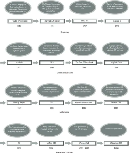
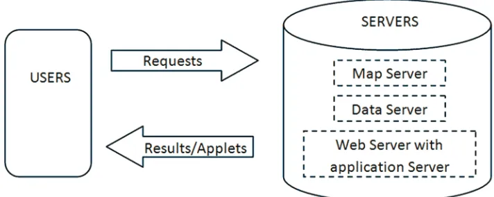
Starting in the early 1990s, new opportunities became available to access and use maps on the Internet. These quickly evolved to incorporate basic GIS functionality of pan, zoom, and map customisation to be followed later by wayfinding tools for route selection. Specific products to de-liver server side Internet GIS through a browser interface started to be available by in the mid to late 1990s, as seen in Figure 1. This represented a fundamental shift whereby different levels of GIS functionality and data sources could be accessed and used online by remote users. Users could have a choice of client side devices from desktop computers, laptops or personal digital assistants (PDA). GIS utilised through an Internet connection are considered as Internet GIS, a phrase which was in use by the late 1990s (Peng, 1999). There have been different terms to describe Internet GIS, such as Web-based GIS (Doyle, Dodge, & Smith, 1998), on-line GIS, distributed geographic information (Plewe, 1997). Figure 2 illustrates the main concept of Internet GIS. On the client side, users send requests for GIS functions through a Web browser via an Internet connection to the server side where GIS software and data reside. Requests have to be processed at server, and the results or applets are then sent back to users via the Internet. There are four basic parts in Internet GIS, which are the user (the client), and the map
server, data server and Web server which reside in the application server (Peng & Tsou, 2003).
[image:7.612.117.473.573.715.2]Two different approaches can be adopted in principle for Internet GIS, known as the server-based approach and the client-server-based approach; most commonly implementations are server-based. In general, the ‘client’ is the side where requests are made whereas the ‘server’ is the side where requests are processed (Peng & Tsou, 2003). Internet GIS using a server-based approach has GIS software residing at the server site. Users will access and employ GIS functionalities via the Internet from their local computers or de-vices. The Web browser is used as a graphic user interface at the client side. The data processing and analysis are performed by GIS software in-stalled at server side. At the client side, users send their requests through the Internet to the server. When the request is received at the server side, GIS software will be activated and relevant data sets opened; the request is processed using GIS functionality and the results sent back to the user, usually as image files. This is the basic principle of how the Internet GIS operate. There is a range of technologies associated with the handling user requests from browsers, which can be from desk-top computers, lapdesk-tops, hand-held devices to smart phones; for parsing user requests to the GIS soft-ware; and for data exchange between Web and GIS software.
Apart from the professional usage of Internet GIS such as for the use of mapping and data col-lection in the field, popular applications accessed by the public are Web-based mapping sites such as Google maps (http://maps.google.com) which through their API allow other users to embed maps into their own Web pages. Access to and use of these sites from smart phones is in many ways very similar to the way these sites are accessed from a PC or laptop as they take no account of whether the user is static (at home or in an office) or on the move.
The advantages of server-based Internet GIS are mainly on its characteristics of centralisa-tion. GIS hardware and software are managed and updated centrally, which can not only be maintained more easily than when decentralised, but also allow users to have consistent access to more up-to-dated functionalities. The server can also have much more computing power and data storage than mobile devices for example and are able to process complex operations more quickly. However, Internet GIS based on this approach can face the challenge when a large number of users send requests to a server simultaneously. Since for all user requests the functionality has to be preformed at the server side instead of at the user (client) side, the system can slow down or even crash in responding to large numbers of user requests.
Another approach of Internet GIS is client-based. It provides users at the client side the ability to run GIS data processing and analysis locally. GIS functionalities as users require are down-loaded from the server onto user’s local devices via the Internet, which can include different level of GIS functions, required data and models. Small executable application applets can be created to carry out different tasks such as managing spatial data, handling maps, performing basic analysis. Such applets can be Java applets, ActiveX con-trols, or other suitable plug-ins for mobile devices. These application applets and plug-ins can be downloaded at runtime to users’ local computers
or their mobile devices. The client-based approach Internet GIS have the advantage of reducing the server side burden of running GIS and data traffic on the Internet. On the other hand, there will be less centralised GIS function and data management. Furthermore, more sophisticated and advanced GIS functionalities may not be possible for users to access and perform on client-based Internet GIS due to lack of power and data storage.
The approach taken for Internet GIS implemen-tation, therefore, depends on the criteria of appli-cations, user volume, telecommunication network capability, and so on. In principle, the Internet GIS with server-based approach are more appropriate to users with certain demands for advanced GIS analysis and modelling functions. The volume of such users accessing any one particular site is less likely to be very high. Employing client-based approach, Internet GIS would be more suitable to applications with large user volume, but not necessary requiring professional advanced GIS functionality. Furthermore, distributed client/ server approach is being developed and employed which can offer more benefit. There will be some discussion in next section.
data-oriented handheld devices (such as tablets and PDA) and mobile phones. Smart phones can be viewed as one such product. A further techno-logical development is the miniaturisation of GPS receivers and accelerometers to small chips so that they can be integrated within mobile devices making them location-aware. These technologi-cal developments (shown in Figure 1) and high levels of ownership of mobile devices provide opportunities for the rise of wireless Mobile GIS.
THE PRINCIPLES AND
FEATURES OF MOBILE GIS
Wireless Mobile GIS are often shortened to wire-less GIS or mobile GIS. In this chapter, we use the term: Mobile GIS. Mobile GIS have resulted from the convergence of wireless mobile tech-nologies, GIS and GPS, offering users real-time access while on the move using devices that are themselves location-aware. This should not be confused with the early usage of the term ‘mobile
GIS’ which were mainly referred to those GIS used for working on site, in the field, through pocket PCs or PC tablets. Those GIS systems could also be connected to GPS to collect and manage spatial data, but most operate as stand-alone GIS. Mobile GIS using wireless technologies enable the real-time connection. Thus, mobile devices (such as smart phones) can synchronise their local data with the database of the GIS on the server, and access and manage data remotely in real-time. Mobile GIS offer the capability of accessing external GIS functionality and applications for users on the move.
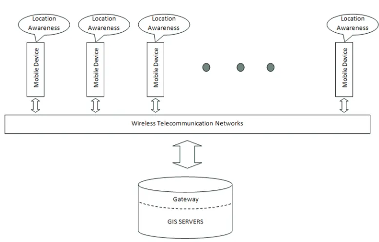
Numerous components are associated with Mobile GIS. Here we focus on the following key elements of Mobile GIS as illustrated in Figure 3: GIS servers; wireless mobile telecommunication networks (connectivity); mobile handheld devices (such as smart phones); location-awareness tech-nology; gateway services.
[image:9.612.100.489.469.717.2]GIS servers provide GIS functionalities, data and applications. The core of GIS, such as GIS data structure and basic functionalities, follow
the same principles of conventional GIS. How-ever, Mobile GIS are not stand-alone as are conventional GIS. As discussed in the last section, Internet GIS adopt a client/server approach to delivery of GIS services to users. In Mobile GIS, when based on client/server approach, a distrib-uted component framework is often employed for users to access GIS. This concept of distributed component framework is different from conven-tional client/server structure. Distributed compo-nent technology allows clients to access hetero-geneous servers dynamically (Tsou, 2004). Utilising such technology, the applications on either client or server side are broken up into a range of components that can be interoperable across networks, operating systems, applications, tools, languages and hardware. Distributed com-ponents can be structured as reusable comcom-ponents which are able to manage complex requests from client side. There are a range of benefits in adopt-ing a distributed component approach in Mobile GIS. One of them is the flexibility of client and server roles in as much as a server can become a client to another server or a client can act as server depending on the distribution and func-tionality of components. Another advantage of using distributed component in GIS is that more complex requests from the client can be managed with sequence priority to offer more efficiency. This is can be beneficial when a server is busy when dealing with large numbers of client side requests. Peng and Tsou (2003) discuss in detail the advantages of distributed components in the Internet GIS. Three major component technologies used in the component-based application develop-ment have been widely applied in developing component-based GIS (Wu, Zhang, & Goddard, 2004). They are: Common Object Request Broker Architecture (CORBA) specification from Object Management Group (OMG); Distributed Com-ponent Object Model (DCOM) from Microsoft Corporation; and Java Remote Method Invocation (RMI) from Sun Microsystem Inc. A distributed
component framework can be applied in Mobile GIS to achieve these benefits.
Distributed Mobile GIS components can be used to provide applications across networks. Take the example of one of the popular distrib-uted component technologies used for mobile devices – the Java platform. Java platform is able to offer support for distributed components in Mobile GIS, particularly Java Micro Edition (Java ME). Java ME emphases applications used in mobile handheld devices, whilst Java SE (Java Standard Edition) is for more general client side applications. Java SE has been used for many Internet GIS applications and Internet mapping. On the other hand, Java Enterprise Edition (Java EE) focuses on server side applications of GIS, such as building distributed components that can be reused for various services. Java ME, with its focus on components for wireless handheld devices, can be used to build applications for Mobile GIS. The major components of Java ME consist of mobile information device profiles, connected device configuration and connected limited device configurations, aiming to provide utility programmes, security and connectivity for small mobile devices
For those architectures that rely on networks for communication between the server and the client, client/server framework and distributed component framework are interrelated. Internet GIS use Web browser as their user interface. Distributed component applications can use Web browser as the user interface, but also could use their own GUI. Different protocols may be used for distributed components in Mobile GIS other than the HTTP protocol which is mostly used in Internet GIS. In general, GIS with distributed components do not have all of the system components in the same physical location. These components could be the processing, the database, the rendering or the user interface. Mobile GIS adopt a distributed component framework to support their services.
The second key element in Mobile GIS is the mobile telecommunication network, which provides wireless connectivity between Mobile GIS users and the network where the main GIS software, data and applications reside. In the early 1980s, the first generation (1G) analogue mobile network was in operation to provide voice traffic. Since then the mobile communication networks have developed through the second generation (2G) in 1990s with digital techniques and data communication ability although limited, to the third generation (3G). 3G networks provide high speed data transmission, which can support fast mobile Internet access and multimedia applica-tions. Only at this phrase of development in mo-bile wireless communication networks, Momo-bile GIS can be realistic and deliver services. Such
where users are. It is similar for accessing Internet GIS. Mobile GIS deliver services and applications to users’ mobile handheld devices, often related to the user’s mobile situation and location. A typical application example can be providing a user on the move the required route to a certain destination based on where they are at that mo-ment. The current location of the user is essential for this service. There are a range of positioning technologies that can be employed in mobile de-vices, such as Global navigation Satellite Systems (GNSS) including Global Positioning System (GPS), mobile network positioning technologies, wireless and RFID location technologies, sensor positioning, visual-aided positioning and hybrid indoor positioning. These positioning technologies are discussed fully in various Chapters in this book.
In order to enable mobile handheld devices (e.g. smart phones) to access GIS servers, mid-dleware is required to link them up. This piece of middleware is the gateway service, which is another element of Mobile GIS. Gateway services provide the capability of translating user requests from mobile devices to GIS servers and format-ting the output back to users at mobile device side. Gateway services also perform tasks such as protocol conversion.
Having discussed a number of key elements in Mobile GIS, we now can look into the main fea-tures in terms of the services and usage of Mobile GIS. These features are mobility; real-time con-nectivity; location-awareness; broadened usage. Mobility is one important feature of Mobile GIS. Mobile GIS has the ability to operate and deliver functionalities, data and services without necessarily requiring a fixed location or wired connection. Mobility feature can also be seen as portability from one aspect. Users can access GIS via their handheld devices while on the move. The mobility feature of Mobile GIS has three charac-teristics, which are: mobile connectivity provided by wireless telecommunication networks; mobile handheld devices (e.g. smart phones) used to ac-cess GIS functions and applications; GIS with
distributed component framework where com-ponents could be the processing, the database or the user interface at different physical locations (servers) to deliver mobile services. Mobile GIS enable data can be captured, stored, and man-aged in remote locations and have the advantage of real-time updating without storing duplicated data. Data can be available from remote systems to mobile users. Information can be uploaded and downloaded between mobile devices and remote systems. The feature of mobility brings GIS out of fixed locations into the field and for people on the move. Use of GIS in mobile situations brings more emphasis on the interaction between the human, mobile device and the environment in human-computer interaction (HCI) research (Li, 2006). Another main feature of Mobile GIS is the real-time connectivity. With this feature, Mo-bile GIS offer the possibility of exchanging and analysing geographical information in real-time in a real geographic world. The interactive ser-vices can be provided with real-time refresh and update. This allows more complex applications such as augmented reality where new data will be delivered as location is changed. It also opens door to applications of push-services, such as proximity advertising. For example, warning mes-sages can be sent to users who are in such areas where disruption and danger are or might occur. The context of users can be taken into account in delivery GIS services, which including user’s physical surrounding, current situation, and their personal preferences and requirements.
GIS applications and services can be available to users according to their location. For example, information can be received for fixed points of in-terest such as nearest restaurant, petrol station and hospitals, or for mobile subjects of interest such as the whereabouts of friends and children. Such devices also enable users’ location to be sent back to servers, which allows Mobile GIS to manage and process real-time data and provide up-to-date applications and services more relevant to users.
Mobile GIS have broadened GIS user groups. Conventional GIS focus more on professional us-ers, both in physical geography and in studying social phenomena to assist decision making and problem solving. GIS have been and continue to be utilised for analysing spatial data, discovering patterns, relationships and anomalies to support science and problem solving. On the other hand, Mobile GIS also provide functionalities and ap-plications to the wider public - services relevant to people’s daily lives. GIS functionality would be accessed and used by people having no GIS professional knowledge. These services can range from: viewing maps from users’ mobile phones, finding nearest facilities, wayfinding, delivering location-related messages, playing mobile games. Such a wide range of user-centred services neces-sitates more emphasis on the interaction between users, GIS and the surrounding environment, which poses challenges in Mobile GIS research. This will be discussed further in the last section of this Chapter.
be accessed, extracted and displayed on user’s mobile devices (e.g. smart phones) in real-time while on the move. Mobile GIS can be seen as the technology that facilitates the creation of mobile services. This leads us into the area of Location-Based Services (LBS).
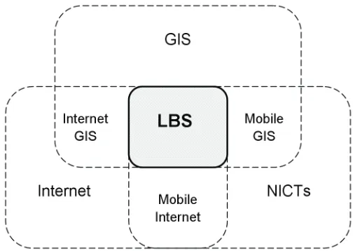
Location-Based Services (LBS) are defined as “the delivery of data and information services where the content of those services is tailored to the current or some projected location and context of a mobile user” (Brimicombe and Li, 2009). LBS can be viewed as the outcome of the convergence of a range of technologies, as dem-onstrated in Figure 4. GIS provides geographical science, technologies and data for LBS. New Information and Communication Technologies (NICTs) have evolved from ICTs with features of mobility and location-awareness. NICTs include a range of technologies associated with wireless mobile telecommunication networks, other wire-less networks, wirewire-less handheld mobile devices (e.g. smart phones) and positioning technologies that integrated into mobile devices. NICTs also have the important feature of having wide usage, near ubiquity, in people’s lives. The convergence of GIS, the Internet and NICTs has made LBS possible. We also can see that LBS are tightly coupled with Mobile GIS. LBS are therefore able to offer data and information services strongly related to user location in mobile situations, in real-time wirelessly.
mo-LBS, individual’s mobile location is used to push (send) relevant information to users either as pre-subscribed requests or independently of a query. For example, information can be delivered to users according to their current locations for all kinds of business and social purposes. This may take the form of proximity advertising and offers of discounted goods, but could also be weather forecast, traffic conditions, delays to trains and flights, warning messages for potential hazards. There is also the element of ‘tracking’, which is monitoring the location of mobile devices con-tinuously. ‘Tracking’ could be used to provide services such as monitoring or managing vehicle fleets, or in entertainment such as location-based games. Furthermore, location related information and services provided by LBS are expected to be updated according to user’s current situation and needs, and to be delivered in real-time. It is es-sential that services provide real-time, up-to-date information pertinent to mobile users.
In order for LBS to provide needed information and services to mobile users, context is important aspect to be considered. The context in LBS mainly refers to the current situation of a user that could be relevant to tailoring location-based informa-tion. Context can be information associated to
user personal situations that might be used in setting up services particularly delivered to these users. For example, large sized text or maps, or louder ring tone could be extra features along with the information provided to those users in need. Context can also be surrounding situation at certain location, such as noisy places, unfamiliar areas. Other context may be time of day, speed of travelling. All these context will have direct effects in tailoring location-based information and services for mobile users. This will be discussed further later in this section.
[image:14.612.188.440.126.305.2]Location-based geographical data and infor-mation provided as services by LBS can take many forms. One of the efficient ways to deliver geographical information is using maps, and is sometimes narrowly viewed as what LBS are. However, LBS should not be simply seen as de-livery of maps to users’ mobile devices. ‘Location’ in LBS concerns more the geographical position of a user as the key to tailoring information rather than the content of any response to a query. Re-sponse to a query can be just text or images, but such information has been tailored to the user, who makes the query, according to his/her mobile location and situation. For example, if a user que-ries the closing time of a car park where he/she
is, the response sent back need only be a simple text message. However, without requiring the user to describe or state exact location of the car park, LBS should be able to deliver the right information in real-time by determining the location through the user’s location-aware mobile device. From this simple scenario, we can see that in adapting information and services according to location, GIS and the use of spatial data are fundamental aspects of LBS.
Information and services provided by LBS can increase their commercial potential when harnessing Mobile GIS. At the same time, LBS also bring emphasis on a range of research ar-eas in GIS and Mobile GIS. These have been discussed in detail in the book “Location-Based Services and Geo-Information Engineering” by Brimicombe and Li (2009). Some of these key areas are issues concerning the availability of data, locating users and how to contextualise the user, their environment and the technology for delivering geographical information services. As discussed, determining the location of a user to whom services are delivered is essential for tailoring information in LBS. The location can be the current position of a user or some future projected location. A number of positioning tech-nologies are available to determine the location of a mobile device, as discussed elsewhere in this book. However, challenges still remain to obtain user location with sufficient accuracy to enable location-based information to be provided with adequate detail and thus ensure utility. The level
will be given to a user according to his/her loca-tion and requirement. The context such as time of the day could directly influence the utility of the information provided as being either as the shortest route or the safest route at night. Informa-tion associated with users and their preferences is another aspect of context in providing tailored geographical information. Technology is a further source of context, being the type of mobile device being used and its capabilities, quality of wireless connection, or the availability of data resources at the time of user request.
widespread use of GIS consumer products on smart phones have consequently aroused a substantial anticipation of Mobile GIS applications for smart phones (Renner et al., 2011).
However, Mobile GIS services remain in their early stage. There is potential and also challenges for mobile software development, as new hardware is being released and various support platforms co-exist. At present, most mobile GIS applications and APIs for smart phones are built on three main mobile operating systems (or smart phone plat-forms) which are Google’s Android, Microsoft’s Phone 7, and Apple’s iOS. Some applications have recently extended to BlackBerry. While individual users can use smart phone applications for their daily life such as finding nearest points of interest, organizations in many sectors can use them to increase operational efficiency such as improving workflow.
The range of applications of Mobile GIS for smart phones are summarised here. Some of them are still potential applications, which are expected to emerge as Mobile GIS mature in the foresee-able future. Others applications have already been developed and are being used to a certain degree. Relevant examples are presented under each category to demonstrate different development procedures and application types.
Applications Mainly for Accessing
and Using GIS Functionality
through Smart Phones
Basic GIS software functionalities can be imple-mented on smart phones through Mobile GIS applications, which are often extended to include some location-based features, such as accessing maps and data relevant to user location, collecting location related data in real-time, real-time report-ing of events with spatial tags. Such applications provide users with smart phones access to basic GIS services in real-time while on the move.
Here are some examples of this type of Mobile GIS application. One of them is ArcGIS Apps for
Smart Phones developed by ESRI, which allows users to navigate maps, collect and report data, and perform GIS analysis via a smart phone. Such ap-plications offer opportunities for smart phone users to view maps and capture information related to their current situation, access content from ArcGIS Online or use functionalities from enterprise GIS, and develop custom applications for user needs. These apps could broaden GIS usage to a much wider public. Another example is applications built using open source software that are increas-ingly available. It becomes practicably feasible to build a specific single application on different mobile platforms. For instance, a new Flex/AIR GIS application for the smart phone BlackBerry has recently developed by WebMapSolutions us-ing Web-based Flex code (www.webmapsolution. com, viewed on August 2011). Building Mobile GIS functionality for smart phones has also been aimed for Apple’s iOS platform using OpenScales Flex sdk’s, ArcGIS Flex API and OpenLayers.
Also in 2008, a solution for accessing GIS through BlackBerry smart phones started to be designed (http://www.3-gis.com, viewed on Au-gust 2011). With the introduction of an application named Buzz for BlackBerry smart phones, users are able to view and query GIS data with their smart phones on the move. Developed to employ the ESRI ArcGIS Server technology, Buzz is aimed at services provided to industries such as the utility, telecommunications and emergency management firms; but also could be extended to other markets with a geo-database. Currently, Buzz can run on the BlackBerry® Pearl™ series, BlackBerry® Bold™ and BlackBerry® Curve™ series smart phones utilizing the AT&T, Sprint, T-Mobile and Verizon Wireless telecommunication networks.
Mobile Applications for Public
and Business Services
numbers of applications are expected for various specialised aspects of public and business ser-vices in the future, as mobile technology itself is evolving. Some of examples are given below to illustrate mobile GIS applications used for public and business services.
One example application is the free BAO (Busi-ness Analyst Online) for Apple’s iOS platform developed by ESRI, aiming to give access to key demographic and market facts about any location in the U.S. through iPhone, iPad, or iPod Touch. This application provides information which can be used to evaluate an area on-site in real-time and assist businesses to understand an area in terms of its geo-demographics. The knowledge of an area can be: types of people living in the location, including a brief demographic and market data summary of a location (e.g. age, gender, socio-economics, and spending habits); the difference between people living in this location from other areas by comparing demographic and market data for two locations or one location vs. the entire U.S. national level data. Such applications may assist businesses to compare and choose prefer-able locations for their services based on needs and criteria. My Place History is another free app from ESRI’s Geomedicine for Apple’s iOS platform which links public health information with user environmental experience. This appli-cation provides services to assist users to better understand their local environment in terms of its effect on their health. U.S. street addresses are used to create and manage a personal place
of location-based services, which converges a range of technologies, can provide a wide range of Mobile GIS applications for smart phones.
Applications for on-Site
Data Collecting, Monitoring,
and Management
Real-time communication and analysis play im-portant roles to support efficient decision making. On-site work can comprise of data collection, monitoring and management as well as those ac-tivities carried out in the field such as identifying key variables contributing to a problem, taking measurements, and inputting and handling data residing locally or remotely. For a variety of fieldwork operations, there has historically been a lag between collecting data on-site and analysing data back at the office, also in exchanging relevant data for analysis and decision making. Mobile GIS applications delivered via wireless networks and mobile handheld devices (e.g. smart phones) offer field operatives the opportunity to do on-site data collection and monitoring while having real-time connection with remote sites (or head offices) to exchange data, to carry out analysis to support decision making or to take action rapidly. Furthermore, using mobile devices for fieldwork has a number of extra advantages such as light in weight and low in cost. Nevertheless there are also a number of disadvantages to using a mobile device in the field such as its comparatively low CPU power for processing data and graphics, small screen size and issues on its compatibility when used alongside other equipment.
One example is a Mobile GIS application aimed at providing and improving GIS ability for field surveying work. SuperGIS Mobile Engine 3
is a Software Development Kit (SDK) developed by SuperGeo (www.supergeotek.com, viewed on August 2011), which can be used to build Mobile GIS applications to meet demands for effectively improving the surveyor’s productivity. Additional GIS functionality can also be created
using SuperGIS Mobile Engine, and then embed into the existing mobile application to provide Mobile GIS functionality to users via their mobile devices. It is aimed for user to develop Mobile GIS applications through SuperGIS Mobile Engine
built-in controls, read-to-use features, to achieve standard GIS functionality in mobile situations. These mobile applications include map display, GPS positioning, file editing, coordinate system settings to meet user needs in the field. They can be built for mobile devices supporting Micro-soft® .NET Compact Framework, such as smart phone, Pocket PC and Tablet PC, and thus reduce the incompatibility problem that often occurs in hardware and software.
Mobile GIS applications, similar to this, often aim to offer users working on-site with capabili-ties such as: collecting spatial data; editing and updating data locally and remotely; accessing maps to obtain up-to-date and relevant spatial data; having positioning ability such as GPS; querying and managing data to assist their fieldwork and decision making. There is a range of examples of such application. One is using mobile handheld device for on-site monitoring of environmental processes (Nurminen, Kruijff, & Veas, 2011). Environmental parameters of certain areas are observed continuously and measured regularly. Spatial data as well as related data such as images are communicated and exchanged between people working on-site and decision maker who are in different locations. Others include field map-ping to update spatial data on-site with attribute information, building and maintaining asset lists with location and attributes, and real-time incident recording into spatial database.
mobile field access to details to support cases and customer activities which will raise support issues in real-time. This mobile application can be used to provide services such as updating service tick-ets from different locations, triggering the billing process and setting up feedback from the field. Similar applications could provide services such as checking availability of products at different locations according to user’s current position and placing orders, communicating and collaboration with other business and organization using real-time on-site information.
With a mobile traffic alert application de-veloped in Ryerson University, Canada, road geometry data can be extracted using GPS data received from smart phones (Niu, Li, & Poursaeid, 2011). Based on road centrelines, this application can be employed to assist capturing road network data. The current conventional methods to obtain such data, either by surveying or by using remote sensing data, are time consuming and expensive. In this application example, GPS data are crowd-sourced through smart phones as an increasingly popular way of collecting data that can be used to provide real-time traffic information, identify traffic patterns, and predicting traffic congestion. The same type of data can be very useful for cost-effective, fast updating of road network databases due to its rich spatial and temporal coverage and high data volume.
Applications for Navigation
and Wayfinding
traffic updates can be delivered to users’ smart phones according to the user’s current location.
Mobile GIS applications that provide wayfind-ing services are more focused on the means by which individuals orientate themselves, discover, and explore surrounding or certain areas of interest. Individual users with their mobile devices could use this type of application to discover points of interest related to their current locations, to find routes to certain destinations or places such as tourist attractions, restaurants, and theatres. Modes of transport and other spatially located objects, landmarks and points of interest can also be provided using location-aware mobile devices. Such applications intend to deliver us-ers a service in real-time according to their need while on the move.
Other Mobile GIS Applications
on Smart Phones
A range of other applications can be identified, many of which have been prototyped and in de-velopment. These applications, along with those applications for navigation and wayfinding, are more closely related to LBS applications: • Real-time tracking: such applications
and flights, warning messages for potential threats, film showing and ticket availabil-ity, menus and local maps.
• Location-based tariffs: such as differen-tials in road pricing, pay-as-you-go car in-surance and similar schemes.
• Coordinating emergency and mainte-nance responses to accidents, interrup-tions of essential services and disasters. • Artistic expression in the community
that might include digital graffiti, location-based story lines and discovery trails. • Mobile gaming where the players and
ac-tions are location-based.
• Social networks where location-aware applications could be implemented with wireless social network tools, such as twit-ter. Users would share their location, and what is on their mind through updating their status, attaching a location to their thoughts and activities. The updated status, with the location graphically depicted by a map, would be available on the screen of smart phones.
The future trends of Mobile GIS applica-tions for smart phones will be interwoven with location-based services, as Mobile GIS, smart phones, wireless telecommunication networks and related technologies are further developed. Mobile GIS enable more people without GIS professional skills to engage with GIS-based ser-vices in a more ubiquitous way. Smart phones are expected to be used by more people on the move as a powerful and readily available thin client for various applications rather than just as phones. More advanced real-time/on-site functionality of Mobile GIS will become available on smart phones due to the advancement of new informa-tion and communicainforma-tion technologies (NICTs). Therefore, the range of Mobile GIS application will continue grow.
PROSPECTS AND CHALLENGES
OF MOBILE GIS
Mobile GIS have come a long way in a short time. They have been facilitated by the rapid develop-ment of mobile telecommunication networks to deliver higher bandwidths, the rapidly evolving design of mobile devices, and the convergence of heterogeneous technologies into single devices that are location-aware. As these technologies further develop, so too will the possibilities for Mobile GIS. However, Mobile GIS are technology dependent and any shortcomings in the technol-ogy will have knock-on effects for Mobile GIS in the implementation and delivery applications (Brimicombe and Li, 2009). Above all, by align-ing GIS with mobility and mobile devices there is the opportunity for engineering GI applications that make GIS part of ubiquitous technologies and at last achieve an embedded mainstream status.
and niche applications of location-based services (LBS).
Whilst the prospects for Mobile GIS are good with plenty of opportunities, there are challenges along the road to ubiquity. These challenges derive from four broad areas: limitations, even threats that derive from the technologies being used; areas of GIScience that still need to be ad-equately researched; users; and business models for a sustainable presence.
The rapid development in mobile telecom-munication network and mobile device technolo-gies will bring even faster data transfer speeds, better connectivity and more advanced devices. This bodes well for Mobile GIS. However, such developments and changes in these industries also raise issues concerning the reliability and consistency of network infrastructure and devices which Mobile GIS rely on to build, implement and deliver applications. For example, the release of the iPhone revolutionised smart phone technolo-gies and required application designers to quickly gear up to this new class of device. The design of the devices (such as screen size and resolution, keyboard/keypad, memory and optional additional memory) is likely to be driven by the more popu-lar uses such as texting, social networking and tweeting and may remain sub-optimal for Mobile GIS. For example, use of gestures across the face of the screen is likely to make query definition more difficult when compared to using a keypad, but a pop-up keypad may obscure too much of the maps being viewed. There is also the issue
to drop. Additionally, GPS in a smart phone for location-awareness will not work and may even give seriously erroneous results where a clear view of three or more satellites is not available. Whilst assisted GPS through the telecommunications network helps overcome some of the effects, it is not a complete solution. Location-awareness may have to rely upon a number of technologies including GPS, A-GPS, accelerometers (which are now available as a chip), and RFID and Bluetooth for locating through beacons.
Mobile GIS raise a number of research areas for GIScience arising from the technology, data requirements and the nature of applications. Im-portant areas are:
de-ture would be that an interface agent would reside on the thin client mobile device and would arrange for each task (such as lo-cating the relevant data, conducting some form of analysis and displaying the result) to be carried out by other agent-based ser-vices residing on servers on the Internet. Functionality and data would be on an on-demand basis. Agent technologies are particularly suited to achieving interoper-ability in heterogeneous computational environments and would thus be a sound structure for Mobile GIS.
• Scalability and response times: For ubiquitous applications of Mobile GIS, the technology will need to be scalable to potentially millions of users without no-ticeable degradation of service. GIS-type queries are typically long transactions, that is, querying spatial data takes much longer than typical database queries of nonspatial data. GIS queries tend to have both high CPU cost and high I/O cost. Thus current approaches to GIS software are unlikely to be sufficiently scalable. Whilst open and interoperable middleware will be impor-tant, a large part of the solution rests in the type of interoperable component systems discussed above.
• Data: There has been a data explosion over the last decade of unprecedented proportions, an increasing proportion of which is spatial data. Many areas of eco-nomic endeavour have become data driven and the focus on high resolution local data has driven new services. Focusing in on lo-cal areas leads to an exponential rise in the amount of data required to satisfy informa-tional needs (such as from Google Earth to Google Street View). Zooming in also requires data to be timelier with shorter up-date cycles. Whilst the technology for this exists, the costs can be high. But whilst conventionally GIS have been deployed
for map data and their attributes, the main mass markets will be for such data to be tegrated into a multimedia approach to in-formation delivery either through on-the-fly mash-ups or by incorporating into GIS non-traditional data that nevertheless have spatial tags (e.g. tweets). This will add an order of complexity to GIS.
• Cognition: This is central to how users of Mobile GIS are going to able to inter-act with the technology in relation to their changing surroundings. Traditionally stud-ies of spatial cognition have focused on how users conceptualise, understand and use map products. But in most interac-tive applications employing Mobile GIS, the user initiates the query, the framing of which will be based on spatial reason-ing derived from their perception and un-derstanding of their surroundings, desired goals and a range of contextual variables. Spatial queries will need to be framed as naïve natural language or gesture-based requests instead of more formal database queries. The formulation of the query is all important in obtaining the desired in-formation and deriving utility from the application.
of portable in-car satellite navigation devices (SatNavs) once they became mass consumer products at the end of 2005. Many purchasers of these products (the first mass consumer products to include GIS software) will have been unaware of the vulnerability to theft that these devices would impart to the owner. Beyond gimmickry and status must-haves, Mobile GIS applications will need to establish markets for services that provide utility to users. That is, the perceived benefits of a service must outweigh the cost or effort in ob-taining the service. This requires business models that promote the utility whilst being able to cover the costs of sustaining the service (Tsalgatidou & Pitoura, 2001). Many users of Internet and mobile services expect them for free and consequently must put up with pushed advertising and other inducements which will cover the cost for the service. This type of business model is likely to be restrictive for services based on Mobile GIS because unless the volume of users is very high, the click rate on advertisements is unlikely to supply revenue that would cover set-up and run-ning costs. Simple applications such as accessing Google Maps are free, but are no different from mobile Internet. More complex applications that provide analytical functions and tailoring based on location-awareness are likely to be subscrip-tion services. The challenge for these services is to provide high levels of utility that are error free in order to be sustained. Services based on Mobile GIS are only at the beginning – this will be an interesting space to watch.
and visualising spatial information on-site and in real-time. Mobile GIS provide core functionality in the context of LBS, while LBS bring Mobile GIS to various aspects of daily life. The research and development of Mobile GIS are still at an early stage, but great potential has been demonstrated for a range of applications. With further progress in wireless mobile technologies and GIS, Mobile GIS will certainly make a substantial contribution in the realisation of ubiquitous GIS.
REFERENCES
Brimicombe, A. J. (2010). GIS, environmental modeling and engineering (2nd ed.). Boca Raton, FL: CRC Press.
Brimicombe, A. J. (2012). Did GIS start a crime wave? SatNav theft and its implications for geo-information engineering. The Professional Geographer, 64.
Brimicombe, A. J., & Li, C. (2009). Location-based services and geo-information engineering. Chichester, UK: Wiley.
Brimicombe, A. J., Li, Y., Al-Zakwani, A., & Li, C. (2009). Agent-based distributed component services in spatial modelling. In Gervasi, O. (Eds.),
Li, C. (2006). User preference, information transactions and location-based services: A study of urban pedestrian wayfinding. Computers, Environment and Urban Systems, 30, 726–740. doi:10.1016/j.compenvurbsys.2006.02.008 Longley, P. A., Goodchild, M. F., Maguire, D. J., & Rhind, D. W. (2005). Geographical informa-tion systems and science (2nd ed.). Chichester, UK: Wiley.
McHaffie, P. (2000). Surfaces: Tacit knowl-edge, formal language, and metaphor at the Harvard Lab for computer graphics and spa-tial analysis. International Journal of Geo-graphical Information Science, 14, 755–773. doi:10.1080/136588100750022778
Niu, Z., Li, S. N., & Poursaeid, N. (2011). Road extraction using smart phones GPS. 2nd Interna-tional Conference and Exhibition on Computing for Geospatial Research and Applications. Wash-ington DC. Retrieved on August 15, 2011, from http://www.com-geo.org/
Nurminen, A., Kruijff, E., & Veas, E. (2011). HYDROSYS - A mixed reality platform for on-site visualization of environmental data. In
Proceedings of the 10th International Symposium on Web and Wireless Geographical Information Systems (pp. 159 - 175). Springer Lecture Notes in Computer Science.
Peng, Z. R. (1999). An assessment framework for the development of Internet GIS. Environment & Planning B, 26, 111–132. doi:10.1068/b260117 Peng, Z. R., & Tsou, M. H. (2003). Internet GIS: Distributed geographic information services for the internet and wireless networks. Hoboken, NJ: Wiley.
Plewe, B. (1997). GIS online: Information re-trieval, mapping, and the internet. Santa Fe, NM: OnWord Press.
Renner, R., Moran, M., Hemani, Z., Thomas, E., Pio, H. S., & Vargas, A. (2011). A comparison of mobile GIS development options on smart phone platforms. 2nd International Conference and Ex-hibition on Computing for Geospatial Research and Applications. Washington DC. Retrieved on August 15, 2011, from http://www.com-geo.org/ Tomlinson, R. F. (1984). Geographic informa-tion systems – A new frontier. The Operational Geographer, 5, 31–35.
Tsalgatidou, A., & Pitoura, E. (2001). Business models and transactions in mobile electronic commerce: Requirements and properties. Com-puter Networks, 37, 221–236. doi:10.1016/S1389-1286(01)00216-X
Tsou, M. H. (2004, July). Internet GIS: Today’s realities and a vision of the future. GIS Develop-ment. http://www.gisdevelopment.net/magazine/ years/2004/july/
Wooldridge, M. (1997). Agent-based software engineering. IEEE Proceedings in Software Engineering, 114, 26–37. doi:10.1049/ip-sen:19971026
Wu, X., Zhang, S., & Goddard, S. (2004). Devel-opment of a component-based GIS using GRASS. In Proceedings of the FOSS/GRASS Users Confer-ence (pp. 11 - 20). Bangkok, Thailand.
ADDITIONAL READING
Braun, P. (2003). Primer on wireless GIS. Park Ridge, IL: The Urban and Regional Information Systems Association.
Brimicombe, A. J. (2009). GIS, environmental modeling and engineering (2nd ed.). Boca Raton, FL: CRC Press. doi:10.1201/9781439808726 Brimicombe, A. J., & Li, C. (2009). Location-based services and geo-information engineering. Chichester, UK: Wiley.
Brimicombe, A. J., & Li, Y. (2006). Mobile space-time envelopes for location-based services.
Transaction in GIS, 10, 5–23. doi:10.1111/j.1467-9671.2006.00241.x
Comer, J. C., & Wikle, T. A. (2008). World-wide diffusion of cellular telephone. The Professional Geographer, 60, 252–269. doi:10.1080/00330120701836303
Drummond, J., Joao, E., & Billen, R. (2007). Cur-rent and future trends in dynamic and mobile GIS. In Drummond, J., Billen, R., Joao, E., & Forrest, D. (Eds.), Dynamic and mobile GIS: Investigating changes in space and time (pp. 289–300). Boca Raton, FL: CRC Press.
Dueker, K. J., & Kjerne, D. (1989). Multi-purpose Cadastre: Terms and definitions. Falls Church, VA: American Society of Photogrammetry and Remote Sensing and American Congress of Sur-veying & Mapping.
Goodchild, M., Yuan, M., & Cova, T. (2007). Towards a general theory of geographic rep-resentation in GIS. International Journal of Geographical Information Science, 21, 239–260. doi:10.1080/13658810600965271
Li, C. (2006). User preference, information transaction and location-based services: A study of urban pedestrian wayfinding. Computers, Environment and Urban Systems, 30, 726–740. doi:10.1016/j.compenvurbsys.2006.02.008 Li, C., & Maguire, D. (2003). The handheld revolution: towards ubiquitous GIS. In Longley, P., & Batty, M. (Eds.), Advanced spatial analysis: The CASA book of GIS (pp. 193–210). Redlands, CA: ESRI Press.
Li, C., & Willis, K. (2006). Modelling context aware interaction for wayfinding using mobile devices. In Proceedings of the MobileHCI, 06, 97–100. doi:10.1145/1152215.1152235
Mountain, D., & Raper, J. (2007). Mixed reality interfaces for mobile information systems. Aslib Proceedings: New Information Perspectives, 59, 422–436. doi:10.1108/00012530710817618 Peng, Z. R., & Tsou, M. H. (2003). Internet GIS: Distributed geographic information services for the internet and wireless networks. Hoboken, NJ: Wiley.
Raptis, D., Tselios, N., & Avouris, N. (2005). Context-based design of mobile applications for museum: A survey of existing practices. In Proceedings of MobileHCI, 05, 153–160. doi:10.1145/1085777.1085803
Shiode, N., Li, C., & Batty, M. (2004). The impact and penetration of location-based services. In Karimi, H. A., & Hammad, A. (Eds.), Telegeoin-formatics: Location-based computing and services
(pp. 349–366). Boca Raton, FL: CRC Press. Tsou, M. H., & Buttenfield, B. P. (2002). A dynamic architecture for distributed geographic informa-tion services. Transactions in GIS, 6, 355–381. doi:10.1111/1467-9671.00118
Wagtendonk, A. J., & de Jeu, A. M. (2007). Sensible field computing: Evaluating the use of mobile GIS methods in scientific fieldwork.
Photogrammetric Engineering and Remote Sens-ing, 73, 651–662.
Walker, M., Turnbull, R., & Sim, N. (2007). Fu-ture mobile devices – An overview of emerging device trends, and the impact on future converged services. BT Technology Journal, 25(2), 120–125. doi:10.1007/s10550-007-0035-3
Wilson, J. P., & Fotheringham, A. S. (Eds.). (2008).
The handbook of geographical information sci-ence. Oxford, UK: Blackwell.
Zipf, A., & Jost, M. (2006). Implementing adap-tive mobile GIS services based on ontologies: Examples from pedestrian navigation support.
Computers, Environment and Urban Systems,
30, 779–784.
KEY TERMS AND DEFINITIONS
Challenges of Mobile GIS: Research chal-lenges raised in Mobile GIS area including limitations derived from the technologies being used, areas of GIScience that still need to be ad-equately researched, users, and business models for a sustainable presence.
GI-Engineering: the design of dependably engineered solutions to society’s use of geographi-cal information.
GIS: Geographical Information Systems, also known as the research discipline of Geographical Information Science. GIS can be defined as a sys-tem of hardware, software, data, people, organisa-tions and institutional arrangements for colleting, storing, analysing, visualising and disseminating spatial information about areas of the earth (Dueker and Kjerne, 1989; Brimicombe, 2010).
LBS: Location-Based Services, the delivery of data and information services where the content of those services is tailored to the current or some projected location and context of a mobile user.
Mobile GIS Applications: A range of soft-ware applications with characteristics of wireless communication, mobility and GIS functionality.
Mobile GIS: Mobile Geographical Informa-tion Systems, with features of mobility, real-time connectivity and location-awareness, broader user audience.