2018 2nd International Conference on Modeling, Simulation and Optimization Technologies and Applications (MSOTA 2018) ISBN: 978-1-60595-594-0
Research on Some Problems of Inland River Channel
Width Determination
Lu-Feng ZHONG, Jia-Hong WANG and Wan-zheng AI
Marine College of Zhejiang Ocean University, Zhoushan 316000, P. R. China
Keywords:Channel, Width, Navigation, Safety, Problem.
Abstract. In general, Generally speaking, most of the inland waterway transportation channels are naturally formed, while a few are artificially excavated. On both sides of the channel, the terrain is complex, and the channel itself has a large length, so it is difficult to find the rule whether the water level changes or the hydrological conditions change. The width of inland waterway affects the shipping safety of ships, so it is very necessary to study the method of determining the width of inland waterway. In this paper, the determination method of distance between ships and distance between ship and bank are studied by using the general layout design theory and probability theory. The method of determining the drift and the distance between ship and bridge caused by the flow in the bend is studied by using hydrodynamic theory. The establishment of inland waterway width should comprehensively use various theories.
Introduction
For shipping, navigation channel is a very important infrastructure and carrier of ship navigation. Its main function is to serve ship navigation. However, China's territory is vast and there are many rivers, lakes and seas. Inland water transportation is an important part of water transportation, which requires us to continuously improve the level of waterway transportation. Normally, the inland waterway is reformed to a certain extent. The depth of the waterway may reach tens of meters and the water traffic is developed. If the waterway is narrow, the number of sluices is large and the water level changes irregularly, this will often bring safety problems to shipping. Under such circumstances, reasonable waterway modification and scientific arrangement of waterway buoys are one of the important guarantees to ensure the safety of shipping work. For setting up channel buoys, it is important to set up boundary buoys on both sides of the channel, and the spacing arrangement between boundary buoys on both sides of the channel is closely related to the width of the channel. The distance setting is too large, wasting channel resources and setting too small, affecting the navigation safety of ships, so the channel boundary buoys must be reasonable and scientific.
As we all know, the main factors affecting the width of inland waterway include: track width, inter-ship spacing, inter-ship spacing, additional width, etc. At present, China's inland waterway navigation standards have clearly defined the width of China's inland waterway. In this standard, the ship's track width, ship-to-ship spacing, ship-to-shore spacing and other parameters are all determined by the representative ship size (captain, ship width). There is no doubt that the ship's track width is related to the ship's length, width and yaw angle. The track width can be completely determined by the length and width of the navigable ship. As for the additional width of the channel, there is no clear definition in the inland waterway navigation standard, especially the additional width of the natural curved channel. The standard only mentions the appropriate widening on the basis of the straight channel width, but the standard does not directly state how much the widening is. Many scholars believe that the additional width of the channel is mainly the drift caused by wind, current and other factors. At present, there are many research results on wind-induced drift and flow-induced drift of straight channel, which can be directly used for reference in buoy arrangement of straight channel [1]. However, as for the curved channel, the flow direction and velocity of the curved circulation all change with the change of water depth, so how to determine the flow-induced
while the inter-ship effect and the quay wall effect are two very complex issues, which are not only related to the size of navigable ships, but also closely related to the flow conditions. Therefore, it is obviously not reasonable to determine the ship-to-ship distance and the ship-to-shore distance simply on the ship scale. For this reason, the key point in determining the width of inland waterway is to solve the problems of inter-ship spacing, inter-ship spacing and drift caused by bend flow. From this point of view, it is necessary to discuss the inter-ship distance, the inter-ship distance and the drift caused by bend flow closely around the navigation safety of ships, so as to lay a foundation for the determination of the width of inland waterway and help reduce the probability of traffic accidents.
Method for Determining Distance between Ships and Distance between Ship and Bank
Design Method of Harbor Master Plan
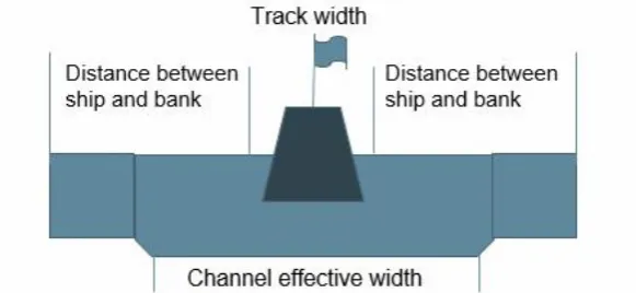
The width of China's inland waterway in the straight line section is determined in accordance with the current Code for Design of Harbor Master Plan[3]. As shown as Figure 2, the effective width of the straight-line channel consists of three parts in total, namely, the inter-ship spacing in the figure, the rich width between the ship and the bottommost edge of the port channel, and the track width. Through the determination of these three widths, the one-way channel and the two-way channel are respectively calculated according to the following calculation formula.
One - way channel: W = A + 2c (1)
Two - way channel: W= 2A + b + 2 (2)
A=n (L*sin r+b) (3) A: Track width in m
b: The distance between ships shall be taken as the design ship width B. c: Rich width of bottom edge of ship and channel
W: Effective width of channel
[image:2.595.153.444.501.635.2]r: Deflection angle of wind and current pressure n: multiple of ship drift
Figure 1. Channel effective width composition (one - way channel).
Probability Method
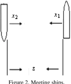
Figure 2. Meeting ships.
Assume that the distance between the up river ship, down river ships and the axis of the sail channel is respectively x1 and x2 (shown as Figure 2). As there is no relationship between the distance of two boat away from the axis of the sail channel, so x1 and x2 are unrelated random variables, and they all follow normal distribution. From Figure 1, we can learn that:
z=z0-(x1+x2) (4)
In the above formula: z represents the distance when the two boat meet in the way. z0 represents the sum of the distances of the two boats away from the axis of the sail channel;
If z>0,that is x1+x2< z0,the collision risk won’t exist
If z<0,that is x1+x2> z0,the collision risk will exist
We can obtain below formula after derivation:
0
0
( ) 0.5
z z
P
(5) From the formula (5), we can learn that, if we set a small value probability P at first when provide the sail channel design ,then we can obtain the corresponding z0, the distance between two boat will
be completely determined. For example, when we design the sail channel, if we need to control the collision risk below 0.005, that is P = 0.005. Then:
0
0
( ) 0.5 0.005 0.495 z
z
(6) According to the formula (6) ,we can obtain:
1 2
2 2 0 2.58 zu 2.58 x x
z
(7) In above formula,x represents the variance of the corresponding value
Considering that there is no much difference in the accuracy of the boat's up river sail and down river sail, in that case, we can let
1 2
x x
,thus we can obtain the below formula by formula (7)
0 3.616 x
z
(8) Relevant research shows that the mean square error is related to the boat's scale, and its size can be determined according to many years of boat navigation observation data in the sail channel. We can obtain the distance between boat and shore in same principle.
Confirm Methods for the Amount of Drift Caused by Curve Flow
the curved circulation flows to the concave bank. As the water depth increases, the circulation gradually decreases. When the water depth reaches a certain depth, the circulation begins to reverse (from the concave bank to the convex bank) and gradually increases. This characteristic of the curve circulation determines that the amount of lateral drift generated by different vessels of the draught is not the same. The curve of the curve can be expressed as:
1.286
4.8 [( ) 0.44( ) 0.307]
r
H
u U y y
r
(9)
In above formula: U represents the longitudinal flow velocity of the curve; H represents the water depth of the curve; y=z/H represents the relative water depth (the water depth starts from the bottom of the river); r represents the curvature of the curve. Since the flow of the cross flow and the flow of the underflow are opposite, for the ship with the draught d, the average curve circulation velocity acting on the hull is:
1
( ) /
d r
H d H
H
u
u dy
d
(10)In above formula: ud represents the average curve circulation velocity acting on the hull.
Combined formula (9) and formula (10), we can obtain:
2.29 2
[0.91( ) 1.49( ) 2.4( ) ]
d
UH H H d H d H d
u
d r H H H
(11)
The formula (11) shows that the average curve circulation velocity acting on the hull is determined by the curvature of the curve, the average longitudinal velocity, the water depth of the curve, and the draught of the ship. Apply the formula (11) to the flow induced drift formula of a straight sail channel, then we can calculate the flow drift of the curved ship.
Method for Determining Distance between Ship and Bridge
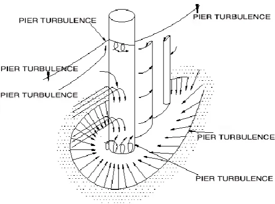
Figure 3. Flow structure in the vicinity of pier.
Conclusion
In the transportation facilities, the navigation channel plays a vital role, is the lifeblood of air China's shipping development and is also the object of state key construction. Therefore, the determination of inland waterway width has been the focus of industry workers' study. Based on the characteristics of ship handling, this paper puts forward a method to determine ship-to-ship distance and ship-to-shore distance from the perspective of probability theory and ship-to-ship theory. From the point of view of hydrodynamics, a method for determining the drift caused by bend flow and a method for determining the distance between ship and bridge are proposed. The above research methods and means in this paper provide a new perspective for the study of other waterway issues.
References
[1] Liu Ming-jun, Ai Wan-zheng, Cheng Zhi-you. Research of navigating capacity in the area nearby Sutong bridge [J]. Journal of ship & ocean engineering, 2006(4):80-85.
[2] Liu Mingjun, Lv Xidao. Necessary width model of ship to getting across channel [J]. Journal of Wuhan university of technology (Transportation science & engineering), 2006, 30(1):178-182.
[3] Transportation department of China. Code for Design of Harbor Master Plan (JTJ211—99) [S]. Beijing: People's Transportation Press, 1999.01.