A Novel Algorithm for Railway Tracks Detection using
Satellite Imagery
Muazzam Maqsood
M.Sc Scholar
Department of Software Engineering U.E.T Taxila, Pakistan
Ali Javed
Assistant Professor
Department of Software Engineering U.E.T Taxila, Pakistan
Nadeem Majeed
Assistant Professor
Department of Software Engineering U.E.T Taxila, Pakistan
ABSTRACT
Image processing applications have their wide ranged importance in today’s world. Railway track detection is one of the hot research areas in visioning systems. An efficient algorithm and high quality images of railway tracks are required for accomplishing the desired task. Images produced by Google maps and Google earth are generally not so extraordinary. Their degraded quality affects the results of detection process. Images will be processed through railway detection algorithms and in the end results are compared with the low quality images in the context of someparameters such as accuracy.Also, the developed algorithm can be included in Geographic information System, so that it can be a base algorithm for other researchers to work on.
Index Terms
Accuracy, catastrophe, Context and locomotive.
1. INTRODUCTION
Railway track detection is one of the emergent areas in image processing as railways are a major transport source in today’s world.Almost half of the cent percent population is travelling from trains so their lives depend on the perfect conditions of the railway systems. Most of the developing nation especially Asian countries lack in having good railway systems. There are so many underlying reasons for this lacking as poor rehabilitation activities after natural disasters like floods, earthquakes, heavy rains etc. Another reason may be terrorism as terrorists mostly target these portions of the country and in the consequence of their actions the railway tracks can get damaged. Lack of funds for railways results in poor maintenance activities. Due to all these reasons the higher authorities like ministers are criticized which further leads to political instability in the country.
The solution to above discussed problems lies in a proper railway detection system. This detection requires some of the geo stationary satellite images which are best provided by the Google maps (street view). Although Google maps provides some decent results but still there are lot of issues associated with it. Firstly there is a problem in accessing the images as Google services are not free of cost for high quality images. Secondly images of developing countries like Pakistan and India are of very low quality. On zooming human eye can’t visualize and detect the accurate track of railways. Google provides high quality images of developed countries like Canada, U.K, USA, France, Germany, Australia and japan. Due to these high quality images railway track can be easily detected.This research work focuses on developing an efficient algorithm for
railway track detection based on images accessed from various sources like internet, camera and street views.
An accurate railway detection algorithm for railway tracks of the whole country would be a long term support. If algorithm provides best efficient and desired results, it can be included as a part of Geographic Information System. So the proposed algorithm will be helpful for different countries to detect their railway tracks by utilizing the base algorithm. On a final note the system will be helpful for government people to properly manage the railway systems after detecting the damaged areas.The research can also be helpful in other academic and scientific fields.
The proposed railway track detection system acquires images of railway tracks from Google imagery and improves the appearance of image in the preprocessing phase by removing noise. The enhanced images further used for detection of railway tracks followed by tagging of tracks for user convenience.
2. LITERATURE REVIEW
Li Cheng; Minglun Gong; Schuurmans, D, Caelli [1], proposed an algorithm for video background subtraction and that algorithm is used when usually background texture continuously changes. They proposed a discriminative algorithm which works very good on video background subtraction. Robustness and efficiency is also compared in with existing systems and results have sown that algorithm is better than the existing systems.
Bi, Xiao-jun , Wang, Ting [2] proposed an algorithm to saolve the issue of blurriness. Image restoration can be done easily by applying this algorithm. In this system, three different classifications are defined for the blurriness like motion blur, defocus blur and Gaussian blur. Algorithm uses some typical and blind restoration methods to achieve the desired results. Result shows that blurriness is reduced effectively and images are enhanced.
Sathya, P.D., Kayalvizhi, R, [3], propsed a system which is based on image segmentation. It is the process of dividing an entire image into different regions or areas. This step comes after restoration and its basic purpose is to Segmentation is the process of dividing an image into separate regions or sub groups. The purpose of segmentation is to denote an image using significant and essential information. That information should be accurate enough to be explored easily. Two most essential attributes of image segmentation are discontinuity and similarity; both of which are based on intensity values.
which assigns label to objects. This assignment is based on some predefined descriptors. Pattern recognition can also be done through machine; this process allocates patterns to the relevant classes which require very little human effort. [4]
Alipoor, M., Ebrahimi, Z.; Haddadnia, J. [5], proposed a new edge detection technique is developed which is actually an extension of sobel edge detection. They introduced some new kernels for some better results which provide a very good distinction between boundaries. They compared their edge detection technique with existing operatives like canny edge operator, Sobel and Prewitt operator.
Xin Chen , Houjin Chen, [6] has done a comparison between the color images and gray scale images. As color images have more prominent edges as compared to gray images because color changes can easily be detected in the image. There are some color edge detection techniques but they are very time consuming so efficiency is a concern in that algorithm. Here a new algorithm is proposed which implemented Kuhawara filter to smooth the images. Then edge detection is applied on each color component of RGB and finally adaptive thresholding is used in combination with edge thinning to find the edges. This algorithm has a drawback that it just does not give adequate results on every color image but overall it gives a satisfactory result on a wide range of color images as well as on many real time applications.
Huili Zhao , Guofeng Qin ; Xingjian Wang,[7] proposed a pavement detection technique, which is based on an improved version of canny edge detection. There are some edge detection issues with canny edge detection, as canny does not detect the weak edges in the gray scale images with small change in gray values. To avoid this problem and to make pavement detection algorithm more accurate, they applied Mallat wavelet transform to get the weak edges from the image. To maintain a good adaptive threshold, genetic and quadratic optimization technique is used. Results show that the results are far more satisfactory as compared to canny edge detection. There is a little issue in this algorithm does not gives satisfactory results on noisy images.
Mastorakis, G., Davies, E.R. [8], proposed a very good line detection technique which is used to find the lines from the images. This algorithm is applied on the images to find the mid points of possible lines markings. There are many assumptions are made for the possible features of lines. There are different distances are calculated like fit tolerance and delete tolerance to find the difference in these distances. On the basis of these distances many false pairs are deleted and results get improved.
Xiaochuan Zhao , Peizhi Liu ; Min Zhang ; Xinxin Zhao [9], proposed a system in which Hough transform is basically used to detect the lines. Hough transform is used with different steps to obtain the required results. Wavelet lifting is used to suppress the small frequency changes and it retains only the high frequency components of the images. Then gradient is applied and then thresholding is done to binarize the input image. Accumulator cell are used to get the get the pixels whose values are higher than the threshold and then from the peak values of the accumulator cells lines are drawn. This is a very efficient technique to get the lines from the images.
Fontanelli, D.,Cappelletti, M.,Macii, D. [10], proposed a system to help robot industry. Here benefits of line detection are used in the robotics industry to make robots more effective and productive for the industry. Existing systems for the line detection are very expensive, so they proposed an algorithm which is very efficient and cost effective. RANSAC algorithm is applied to find the lines which are used in the real time trajectory monitoring systems.
3. RELATED WORK
Ali Javed, MuazzamMaqsood [11]has introduced an efficient algorithm for railway track detection. This algorithm was applied on satellite imagery. This algorithm compares the results of different edge detection operators like sobel, canny and Prewitt. These techniques are applied on low quality railway track images. The designed algorithm helps in detecting damaged railway lines, railway crossings. This further helps in detecting locomotive motion which reduces accidents.
Track Selective localization is a technique introduced by Ross; R. [12] in which a video camera with mono focal is used for enhancing the quality of localization. Track selective localization makes use of recursive estimation in case of images taken by camera. Recursive estimation helps in identifying the location of tracks in the given images. Turnout detection is done by the results gathered from recursive estimation.
Jenita Subash[13] worked on satellite images for automatically extracting roads. This extraction is done through two algorithms named: Extended Kalman Filtering (EKF) [14] and variable structured multiple model particle filter (VS-MMPF)from satellite images is addressed. The first algorithm is used to trace out the axis of road. The axis should be median and road should be a single one. The other algorithm VS-MMPF is used to trace out the roads meeting at intersections. A filter named Local Linearization Particle Filter (LLPF) is also used in this algorithm.This filter requires some particles in huge number which increases the expenses of computations. Profile matching is the fundamental principle of the system.
Detection of objects in motion requires a moving camera and an efficient algorithm. This algorithm is proposed by Zu Whan Kim [15] and is implemented in steps. First one is the estimation in which the ego motion of the camera is estimated. In the detection step,object features are used for to detect the unreliable motion as compared to moving camera.
4. PROPOSED METHODOLOGY
In this section proposed methodology is explained in detail which consists of the following steps.
4.1
Image Acquisition
Images play a vital role in the processing of the desired research projects. In computer vision and image processing applications which works on the detection of objects.Areas and regions are firmly dependent on the quality of the perceived images. So proper emphasis should be given to this fundamental step. For this particular research, major requirement is to gather railway track images. The desired images have been collected from three available sources including Google Maps, Street View of European Countries and HD cameras for capturing high definition images.
4.2
Edge Detection
The proposed system converts the acquired colored image into Gray scale image followed by the process to find the gradients of the image and their magnitude.
Once gradients and their magnitudes are calculated, an adaptive thresholding technique is used to find the pixels which should be counted as edges. Pixel indices are very important for further processing because pixel’s indices and angles are very important for the line detection.
An accumulation array is built to store all voting pixels which satisfy the threshold. When voting is done, angles of the voting pixels are calculated and that information is also stored in the array. Without getting the direction of the pixels lines can’t be detected.
Gradient vector helps to determine the accurate length of the gradient size. Therefore to calculate the length of gradient size, gradient vector is obtained first.
In real life, straight line equation is used to find the lines using this equation:
(i)
But in Hough Transform, polar representation of lines are used with equation
(ii)
InHough Transform, it is very difficult to work on pixel’s coordinates, that’s why indices or coordinates are transformed into angles and rho to get the better results for the algorithm. For this purposerho of all the voting pixels are calculated to form a rho vector.Whenrho vector is formed, eventually an accumulation array with Gradient weight has been textured.
5. Object segmentation from Region of
Interest (ROI)
It is not feasible to work on the whole image at once. To resolve this issue segmentation is done on the image on the basis of Hough transform graph. Hough transform graphpresents the location of edges in the image.The specified algorithm finds the local maxima from all regions of interest and local maxima can give significant number of lines.
In the first step image is divided into different regions of interest and local maxima is calculated for each division. Once calculating all the local maxima’s is done, a cumulative image is obtained as if it is the only region of interest.
6. Line detection through connected
component
Line detection involves detection of lines in the resultant image taken after calculating local maxima’s. Every local maxima gives another line in the image. Every pixel around the local maxima is checked whether it belongs to the line or not. All linear pixels eventuallyform a single line.
Hence, lines are drawn on the basis of adjacencies and if a segment under process is too large, it is once again subjected to segmentation.
7. Railway track detection
Detection of railway track is the ultimate goal of the current research. In the previous step all the lines in the image is detected and drawn on the image and finally in last step results are refined and only railway tracks are detected and highlighted.
Two of the most important factors which play major part in the detection process are length and width of the track.
Efficiency of the system can be seen from the fact that it not only detects the straight tracks but it also detects the tracks which are tilted at an angle.
8. Labeling of railway tracks
The final step in the algorithm is the labeling of track. In previous step, onlythose lines were left which represents the railway track. In the final step two of the detected points are taken under consideration to draw the ultimate lines and finally label them with the appropriate colors.
9. EXPERIMENTAL SETUP AND
RESULTS
9.1
DataSet
In computer vision and image processing, dataset plays an important role in the development process. Researchers include almost every type of data in their dataset to test their algorithm on possible inputs. In this way an algorithm can be made more generic and results can be more satisfying and accurate.
For the proposed system, images of the railway tracks have been taken from camera. Some images have been gathered from satellite imageryof Google. Further testing of the proposed algorithm can be done on street views. Street view contains some of the very high quality images of railway tracks. The proposed algorithm has been applied on a data set of hundred images; all giving satisfactory results. The accuracy of results varies a bit with the quality of images,as quality of Google images is not very good for Asian countries.
9.2
Results and Analysis
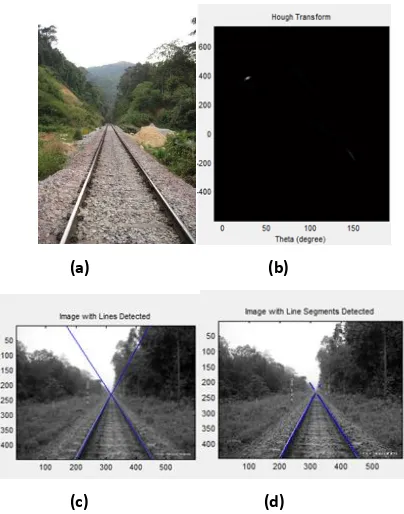
(a) (b)
(c) (d)
Figure 1: (a) Original Image, (b) Hough Transform of the image, (c)Result with all lines detected, (d) Result
with only railway tracks.
Figure 1(a)show the image which is captured by camera containing the railway track, in figure 1(b) Hough transform is formed and in figure 1(c) all detected lines are shown. Figure 1(d) shows the final results, in which only railway track is detected.
(a) (b)
(c) (d)
Figure 2: (a) Original Image, (b) Hough Transform of the image, (c) Result with all lines detected, (d) Result
with only railway tracks.
In the previousoutcomes, image is taken from the Google imagery and the algorithm detects the railway track accurately. Even though the image was taken from almost height of 400 feet but the results are very good. Sequence of the images is same as previously explained.
(a) (b)
(c) (d)
Figure 3: (a) Original Image, (b) Hough Transform of the image, (c) Result with all lines detected, (d) Result
with only railway tracks.
Furthermore; algorithm has been successfully applied on images taken at dark. Results of the detected railway track have been shown above in figure 3.
(a) (b)
(c) (d)
Figure 4: (a) Original Image, (b) Hough Transform of the image, (c) Result with all lines detected, (d) Result
[image:4.595.55.257.70.327.2] [image:4.595.324.533.131.369.2] [image:4.595.56.266.427.664.2] [image:4.595.324.540.451.688.2]These are the result of street view images of European country. The proposed algorithm is efficeint enough to detect the results.
10. CONCLUSION & FUTURE WORK
Efficiency of the Algorithm developed in this particular research work can be proved from the experimental results. The algorithm gives accurate results for detection of railway track images taken from Google maps or cameras at different angles and positions. Algorithm provides desired results for both the good and the poor quality images. It can be helpful for further researchers if they want to develop a track detection system for whole country. As Google images for under developed countries are not of high quality so the developed efficient algorithm would be a base for future work to carry on. It gives same results for all the images either taken from street view of Google maps or taken by high definition digital cameras.
Its utilization lies in detecting obstacles in the way of tracks so that accidents or other mishaps can be avoided.Another considerable utilization could be differentiating roads from railways in the satellite view of Google maps. This could be effective if the algorithm becomes part of a GIS.
Extension of the proposed research workcould be done in many related areas includingRailway Track Monitoring and some interconnectivity methods between various units of safety related fields.
11. ACKNOWLEDGEMENT
We are very thankful to all the experts who helped us in this research.
12. REFERENCES
[1] Li Cheng; Minglun Gong; Schuurmans, D, Caelli, T.; “Real-Time Discriminative Background Subtraction Image Processing’’, IEEE Transactions, pp. 1401 – 1414, May 2011.
[2] Bi, Xiao-jun , Wang, Ting , “Adaptive Blind Image Restoration Algorithm of Degraded Image” Image and Signal Processing, 2008. CISP '08. Congress, pp. 536 – 540, 27-30 May 2008.
[3] Sathya, P.D., Kayalvizhi, R, “Image segmentation using minimum cross entropy and bacterial foraging optimization algorithm Emerging Trends in Electrical and Computer Technology (ICETECT)”, 2011 International Conference, pp. 500 – 506, 23-24 March 2011.
[4] Pi Youguo , Shu Huailin ; Liang Tiancai ,” The Frame of Cognitive Pattern Recognition ” Control Conference, 2007. CCC 2007. Chinese, pp. 694 – 696, July 26 2007-June 31 2007.
[5] Alipoor, M. , Ebrahimi, Z. ; Haddadnia, J. , “A novel logarithmic edge detection algorithm ”, Machine Vision and Image Processing (MVIP), 2010 6th Iranian, pp. 1 – 6, 27-28 Oct. 2010.
[6] Xin Chen , Houjin Chen , “A novel color edge detection algorithm in RGB color space”, Signal
Processing (ICSP), 2010 IEEE 10th International Conference, pp. 793 – 796, 24-28 Oct. 2010.
[7] Huili Zhao , Guofeng Qin ; Xingjian Wang, “Improvement of canny algorithm based on pavement edge detection”, Image and Signal Processing (CISP), 2010 3rd International Congress, pp. 964 – 967, 16-18 Oct. 2010.
[8] Mastorakis, G. , Davies, E.R. , “Improved line detection algorithm for locating road lane markings”, Electronics Letters, pp. 183 – 184, February 3 2011.
[9] Xiaochuan Zhao , Peizhi Liu ; Min Zhang ; Xinxin Zhao , “A novel line detection algorithm in images based on improved Hough Transform and wavelet lifting transform”, Information Theory and Information Security (ICITIS), 2010 IEEE International Conference, pp. 767 – 771, 17-19 Dec. 2010.
[10] Fontanelli, D. , Cappelletti, M. ; Macii, D. , “A RANSAC-based fast road line detection algorithm for high-speed wheeled vehicles”, Instrumentation and Measurement Technology Conference (I2MTC), 2011 IEEE, pp. 1 – 6, 10-12 May 2011.
[11] Ali Javed, Khurram Ashfaq Qazi, Muazzam Maqsood, Khurram Ali Shah, “ Efficient Algorithm for Railway Tracks Detection for Satellite Imagery" published in International Journal of Image, Graphics and Signal Processing, Vol. 4 No. 11 pp 34-40 October 2012.
[12] Ross, R. ,” Track and turnout detection in video-signals using probabilistic spline curves” Intelligent Transportation Systems (ITSC), 2012 15th International IEEE Conference on, pp. 294 – 299, 16-19 Sept. 2012.
[13] Jenita Subash, “automatic road extraction from satellite images using extended kalman filtering and efficient particle filtering”.
[14] Movaghati, S.; Moghaddamjoo, A.; Tavakoli, A.; “Road Extraction From Satellite Images Using Particle Filtering and Extended Kalman Filtering Geoscience and Remote Sensing”, IEEE Transactions, pp. 2807 – 2817, July 2010.
[15] Zu Whan Kim , Huertas, A. ; Nevatia, R. , “Automatic description of complex buildings with multiple images”, Applications of Computer Vision, 2000, Fifth IEEE Workshop on., pp. 155 – 162.
[16] Fatih Kaleli and Yusuf Sinan Akgul, “Vision-Based Railroad Track ExtractionUsing Dynamic
Programming” GIT Vision Lab,
http://vision.gyte.edu.tr/.