http://dx.doi.org/10.4236/eng.2014.611070
How to cite this paper: Sissakian, V.K., Abdul Jab’bar, M.F., Al-Ansari, N. and Knutsson, S. (2014) Meandering of Tributaries of the Tigris River Due to Mass Movements within Iraq. Engineering, 6, 712-730.
http://dx.doi.org/10.4236/eng.2014.611070
Meandering of Tributaries of the Tigris
River Due to Mass Movements within Iraq
Varoujan K. Sissakian1, Mawahib F. Abdul Jab’bar2, Nadhir Al-Ansari3*, Sven Knutsson3 1Consultant Geologist, Erbil, Iraq
2Iraq Geological Survey, Erbil, Iraq
3Lulea University of Technology, Lulea, Sweden
Email: varoujan49@yahoo.com, mawaheb_geosurv@yahoo.com, *nadhir.alansari@ltu.se,
Sven.Knutsson@ltu.se
Received 12 August 2014; revised 4 September 2014; accepted 20 September 2014
Copyright © 2014 by authors and Scientific Research Publishing Inc.
This work is licensed under the Creative Commons Attribution International License (CC BY).
http://creativecommons.org/licenses/by/4.0/
Abstract
Tigris and Euphrates are the main rivers in Iraq. The former has 5 main tributaries while the lat-ter has no tributaries within Iraq. All these rivers exhibit meandering and/or shifting of their courses due to many reasons; such as mass movements and alluvial fan's development. The meandering and shifting of river courses due to mass movements is dealt with in this study. Many examples are given from different parts of Iraq within different rivers and streams. In each case, the geology of the involved area is described; the reasons of the shifting and/or meandering of the river course are given. GIS technique was used to determine the coverage of the involved area. Landsat, Google Earth and DEM images were used to indicate the suffered areas from shifting and meandering of the rivers and streams. When possible, age of the shifting and/or meandering of the river and stream courses was estimated; using exposure age determination; mainly depending on the presence of river terraces, erosional forms, vegetation cover and the maturity of the involved area. Some of the given examples of shifting of river courses were found to be still active; others are inactive. In many cases, indications for very large mass movement phenomena were seen. Moreover, some of the large involved areas are highly populated, others includes few houses and/ or farms. The majority of the meanders are developed due to mass movement phenomena; others are caused by alluvial fans and/or tectonic features, lime plunging of anticlines.
Keywords
Tigris, River Meanders, Mass Movements, Alluvial Fans, Erosion, Iraq
*
1. Introduction
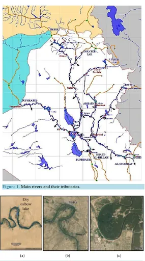
[image:2.595.157.442.188.700.2]Iraq is part of the Middle East. It covers an area of 433,970 square kilometers populated by about 32 million in-habitants (Figure 1 and Figure 2) [1] [2]. Iraq is well known by its two main rivers the Tigris and Euphrates, the former has five main tributaries; called Fiesh Khabur, Gretaer Zab, Lesser Zab, Adhaim and Diyala (Sirwan), in addition to tens of sub-tributaries [1] [3] [4]. All of them exhibit acute meanders along their courses. Some of the meanders are formed due to tectonic influence, when the course follows a plunge of an anticline; others are formed due to mass movement phenomena. The braided river system, however, also forms meanders, but are not acute as those formed due to tectonic influence and/or mass movement phenomena.
Figure 1. Main rivers and their tributaries.
(a) (b) (c)
Rivers usually form normal meanders along their courses, especially when they are considered as old rivers. The same river; however, can have three stages of maturity; these are: youth, mature and old during its course, but in different places [5]. This depends on the morphology and relief difference of the land through which a river is flowing. Good examples in Iraq are the Euphrates, Tigris and Diyala rivers (Figure 2), where they form a series of meanders along their courses, not related to mass movements.
The mechanism of normal meandering is explained in Figure 3, where erosion took place in the outside part of a bend and deposition in the inside part of a bend. The river may erode an acute meander during heavy floods leaving an oxbow lake, which may dry after a certain time (Figure 3). However, meanders may develop due to tectonic influence, when a river follows along a plunge of an anticline; due to alluvial fans (Figure 4); or the course is shifted due to a mass movement, where the course turns round the moved mass. The latter case is the objective of the current study.
[image:3.595.95.536.231.414.2]
(a) (b)
Figure 3. Meander formation. (a) Process on a meander bend; (b) Map view (Internet data).
[image:3.595.91.527.356.682.2]Mass movements have different terminology in different literatures; they include four main types (Figure 5): Slide, fall, creep and flow [6] [7]. In Iraq, the main types of mass movements are: Flow and slide [8] [9]. The active mass movements, in Iraq are in the north and northeast, with decreasing frequency towards the central part, where they totally diminish within the Mesopotamia Plain, due to type of the sediments and low relief. One of the main reasons for triggering mass movements is the change in pore water pressure [10] [11].
Mass wasting, also known as slope movement or mass movement, is the geomorphic process by which soil, sand, regolith, and rock move downslope typically as a mass, largely under the force of gravity, but frequently affected by water and water content as in submarine environments and mudslides. Types of mass wasting in-cludes creeps, slides, flows, topples, and falls, each with its own characteristic features, and taking place over timescales from seconds to years [12].
No direct specialized work was carried out in Iraq concerning meandering of rivers due to mass movement. However, very few articles were published concerning mass movements in different parts of Iraq, among them are:
-Sissakian [8] reported about different types of mass movements in Iraq and concluded that the most common types are mud flow, toppling and landslide.
-Sissakian [9] reported about the types of mass movements in Iraq with many examples and their geological hazards affect.
-Sissakian and Fouad [13] reported about the morphotectonics of the Tigris River in the central part of Iraq and concluded that many meanders in the river were due to landslides.
-Karim et al. [14] studied a large landslide in Pera Magroon Mountain, north Iraq and deduced the reasons and movement rate of the landslide.
-Sissakian et al. [15] studied the existing landslides in Khanooga area, central part of Iraq, along the Tigris River and concluded that part of the meandering of the river was related to a landslide.
-Sissakian et al. [16] studied the influence of the mass movements on Makhoul dam; located on the Tigris River and concluded that the existing landslides will affect the stability of the dam after impounding of its re-servoir.
-Sissakian and Abdul Jab’bar [17] studied the transversal streams in northern parts of Iraq and concluded that the courses of some streams were related to landslides.
[image:4.595.122.473.456.704.2]-Hamsur [18] studied the influence of the mass movements on the stability of the proposed Bassara Dam, norht Iraq.
Meandering can form an obstacle for any engineering work or hydrological study unless the reason for mean-dering is revealed, especially when it is still active. The aim of this study is to investigate some of the main acute meanders along the Tigris River and some of its main tributaries in different parts Iraq (Figure 1 and Figure 6). The reason of the existence of the meander is given and, age estimation for its development is also given, when relevant indication(s) is available.
2. Materials and Methods
To achieve the aim of this study, the following materials were used: -Geological maps, at scale of 1:100,000, 1:250,000 and 1:1,000,000 -Topographical maps, at scale of 1:100,000 and 1:250,000
-Geological reports concerning this study -Google Earth, DEM and Satellite images -Relevant published articles and thesis
-GIS techniques and programs to indicate some numerical data concerning the involved areas.
The geological and topographical maps with the Google Earth, DEM and Satellite images were used to rec-ognize the indications of mass movements and their effect on meandering of rivers and streams. Within GIS and Digital Elevation Model (DEM) applications, spatial analysis and hydrological tools of Arc GIS were used to calculate the involved parts in the studied area. The simplest morphological analysis involves the study of eleva-tion data. In the present approach, DEMs were displayed for visual inspeceleva-tion as grey-scale images, 3D surface views, and shaded relief models or as combinations of these. Some structural data were also reviewed to eluci-date the relation between surface geology and the meandering.
3. Hydrological Characteristics of the Iraqi Rivers
[image:5.595.129.467.422.708.2]The rivers Tigris and Euphrates with their tributaries form the main surface resources in Iraq. Details of these basins can be found in [1]-[3]. The catchments area of these rivers is shared by five countries: Iraq, Turkey, Iran, Syria and Saudi Arabia (Figure 1 and Figure 6).
The River Tigris rises in the southeastern part of Turkey on the southern slopes of the Touros mountain range and drains an area of 472,606 km2 which is shared by Turkey, Syria and Iraq. Its total length is about 1800 km (Figure 1 and Table 1). About 58% of the basin lies in Iraq. Three major tributaries (Butman Su, Karzan and Razuk) join the Tigris before it reaches the Turkish/Iraqi border. The mean annual flow of the river does not ex-ceed 64 m3/S and it increases at Razuk to 413 m3/S. It enters Iraq at Fiesh Khabur where the Khabur tributary joins the main river at a small distance to the south. The mean annual flow of the Khabur is 68 m3/S. It is 181 km long and drains an area of 6143 km2. The River Tigris flows towards the south and reaches the first major city (Mosul). Its mean discharge at Mosul reaches 630 m3/S.
The Greater Zab River joins the Tigris about 60 km south of Mosul. The confluence of the two rivers is si-tuated midway between Mosul and Sharkat cities. This tributary drains an area of 25,810 km2 of which about 62% lies in Iraq. This tributary is one of the largest with a mean annual flow of 418 m3/S and it is 462 km long.
Further south, the Lesser Zab tributary joins the Tigris at Fatha. This tributary is 302 km long and drains an area of 21,476 km2 (75% in Iraq) with a mean annual flow of 227 m3/S whiles the mean annual flow of the Ti-gris reaches 1340 m3/S downstream of this confluence. South of Fatha, the Adhaim tributary joins the Tigris. This tributary is 330 km long and drains an area of 13,000 km2 which lies totally in Iraq [20]. The mean annual flow of this river reaches 25.5 m3/S. This tributary runs dry between June and November each year. Further to the south, the last major tributary, the Diyala River joins the Tigris south of Baghdad. The Diyala basin is 31,846 km2 of which about 20% lie in Iran. The mean daily flow of this tributary is 182 m3/S and the river is 574 km long.
No major tributary joins the River Tigris south of Baghdad. Few canals draw water from the Tigris in this re-gion for irrigation purposes. For this reason, the mean annual daily flow of the river falls below its value at Baghdad (1140 m3/S) in Kut and Amara cities at the south [21] [22].
The River Euphrates is 2786 km long and rises from the southeastern parts of Turkey. It drains an area of 444,000 km2 shared by four countries (Iraq 41%, Turkey 28%, Syria 17% and Saudi Arabia 14%) (Table 1). The Rivers Karah Su and Murad Su join together in the southeastern parts of Turkey at Kuban forming the River Euphrates. The River enters Syria at Jarablis where it runs 675 km and then enters Iraq. Thirty kilometers south of Jarablis, the Sajor tributary joins the Euphrates. Further downstream, two tributaries, the Balikh and Khabur, join the main river after which it crosses the Iraqi border at Hasaibah. The mean daily discharge of the Euphrates River inside Iraq (at Hit) is 909 m3/S [23] [24]. Inside Iraq, no tributary contributes water to the river. The river supplies a number of small canals in the central and southern parts of Iraq for irrigation purposes (Figure 1). Some of its water is diverted to the Habaniya reservoir during floods, which is situated about 40 km south of Ramadi. About 135 km south of Faluja, the Hindiya barrage diverts a maximum discharge of 471.5 m3/s to small parallel tributaries.
[image:6.595.94.505.563.721.2]The Euphrates channel south of Kifil is divided into two main channels (Kufa and Shamiya), and they joins again at Mushkhab. Further downstream, the channel splits again about 25 km south of Shanafiya and rejoins near Simawa. Then the river enters Hamar marsh, where it forms two main channels within Hamar marsh. One of the channels (northern) joins the Tigris River at Qurna orming (known as the Shat Alarab River) while the other channel joins the Shat Alarab River at Karmat Ali.
Table 1. Characteristics of tigris and euphrates rivers (source [1] [2]).
River Tributaries inside Iraq Length (km)
Catchment area
Flow (m3/S)
Total (km2) Inside Iraq (%)
Tigris
Main River 1800 472,606 58 630 (Mosul)
Fiesh Khabur 181 6143 43 68
Greater Zab 462 25,810 62 418
Lesser Zab 302 21,476 75 227
Adhaim 330 13,000 100 25.5
Diyala 574 31,846 80 182
It is noteworthy to mention that the Tigris and Euphrates River discharge changes with time (Figure 7). These changes are due to the global climate change and the dams constructed in Turkey and Syria. There are 8 dams on Euphrates in Turkey and Syria and 5 dams on Tigris in Turkey. The Tigris River mean discharge at Mosul city prior to 1984 was 701 m3/S and dropped to 596 m3/S afterward [1]. This implies that 15% of the river discharges were been decreased. The Euphrates River mean discharge at Hit and Haditha cities prior to 1972 was 967 m3/S and dropped to 553 m3/S after 1985 [1]. The percentage decrease in river discharge is 43%.
4. Examples of River Meandering Due to Mass Movements.
Using different types of images, tens of meandering of rivers and streams due to mass movement phenomena were recognized in different parts of Iraq. The best representative examples were selected and presented in this study. In each case, the geology, type of the movement, coverage of the involved area, reason of triggering and if possible; the age of the mass movement phenomenon was estimated. The selected examples were classified according to the river and/or stream through which the meandering occurs, the involved areas are shown in Fig-ure 1. Hereinafter are selective and representative examples of meanderings in different rivers; caused by mass movements.
4.1. Tigris River
[image:7.595.131.467.355.702.2]The Tigris River, in Iraq flows in low relief mountainous areas; therefore, no large mass movements have oc-curred that caused shifting of the river’s course. However, few meandering due to mass movements occur along the river’s course.
Figure 8 shows two meanders caused by mud flows along the course of the Tigris River. The involved areas are built up of the Fatha Formation (Middle Miocene) [13]; it consists of cyclic nature of rocks, each cycle con-sists of green marl, limestone and gypsum. These three rocks of different mechanical characters are highly sus-ceptible for different types of mass movements, especially after being highly saturated during heavy rain show-ers, besides the undercut erosion of the Tigris River. The involved area represents the southeastern plunge of Mashoora Dagh anticline [25]. The traces of the mud flow are still present in the enlarged part of (Figure 8). The river, originally was meandering around the plunge (M in Figure 8), with vast flood plain (FP in Figure 8), after a mud flow the first meander was developed (No. 1 in Figure 8), then a second mud flow had occurred (No. 2 in Figure 8), which had shifted the first meander, as indicated by its strange asymmetrical meander and bulg-ing opposite to the course of the river. After that the river had eroded and deposited its flood sediments along the meanders, consequently, modeling and modifying the easiest path, which is still in action and can be seen in the last meander bellow the water of the Mosul Dam reservoir (Figure 8). The age of the mud flow is very old since no traces of the old river course can be seen, apart from the cliffs (C in Figure 8), which indicate the original course of the river, and the large formed flood plains, especially in meander No. 1. The coverage area of the in-volved area is about 2.24 Km2.
4.2. Greater Zab River
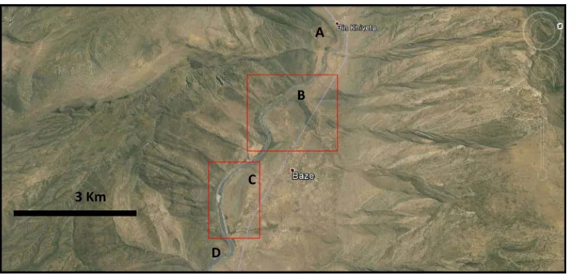
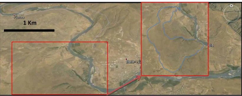
[image:8.595.97.532.445.703.2]The Greater Zab River is one of the main tributaries of the Tigris River (Figure 1); it flows within very rugged topography with high relief difference, which enables the development of different types of mass movements. Figure 9 shows many meanders along the course of the Greater Zab River, all of them are formed due to landslides. Originally, the course of the river was almost a straight line (A, B, C and D, Figure 9) flowing pa-rallel to the axis of a syncline between Shireen and Gara anticlines, the trough of the syncline is capped by Tan-jero and Shiranish formations [26]-[28]. The landslides and mud flows happened in the Shiranish and TanTan-jero formations, the river course was shifted in two locations; southwest wards. The trace of the ancient river course is still present in many localities (Figure 10). The age of the mass movements is very old, because the crown areas of the movements are vanished, moreover, the facing parts of the river suffer from active erosion indicat-ing activity of the movements. The coverage area of the first part (B) is 1.258 Km2 whereas that of the second part (C) is 0.982 Km2.
Figure 9.Google Earth image facing NE, of the Greater Zab River, with two captions. Note the original align- ment of the river ((A), (B), (C) and (D)).
Figure 10.Google Earth images facing NE. Left: Caption B and Right: Caption C. Note the trace of the ancient river course (in blue) and traces of active erosion along the cliffs on the facing side of the river.
Figure 11 shows example of a meander within the Greater Zab River shifted by a mass movement. Originally, the river was meandering normally west of Bele town. The exposed rocks belong to the Tanjero and Shiranish formations [27]. The former consists of fine clastics with some coarse conglomerate, whereas the latter consists of bedded limestone overlain by marl. The meandering was modified by a landslide (Figure 11), the inner limit in the caption), which was shifted the river course NE wards. The age of the landslide might be few hundred years, since the crown area is still visible, beside the old course of the river, along the meandering. The coverage area of the involved part is about 0.777 Km2.
4.3. Lesser Zab River
The Lesser Zab River is the second main tributary of the Tigris River (Figure 1). Figure 12 shows a complex meandering style of the river, which flows; in this part within the Fatha Formation [26] [28]. The Fatha Forma-tion consists of marl, limestone and gypsum in cyclic nature. This combinaForma-tion of three components with dif-ferent mechanical characteristics leads to favorable condition for mass movements.
Figure 11. Google Earth image of the Greater Zab River. Note the limits of the landslide (the blue inner line) that has shifted the river course NE wards. Another large one (the bluer outer line) will be triggered when the con- ditions are favorable.
Figure 12. Google Earth image of the Lesser Zab River showing complex meandering. The blue line is the limits of the original meander of the river.
[image:10.595.92.507.292.547.2]The landslide that had caused meander No. 1 is very old, most probably late Holocene, since the river terraces of Pleistocene age, which are developed along the river course; are covered by the landslide (Figure 13). The other mass movements, which had caused the other meanders (Figure 12) are few hundred years old. The cov-erage areas of the six meanders (No. 1, 2, 3, 4, 5, and 6) are (11.25, 1.482, 1.525, 1.32, 3.24, 2.745 and 6.615) Km2, respectively.
4.4. Diyala River
The Diyala (Sirwan) River is the third tributary of the Tigris River (Figure 1), it inters Iraqi territory in the nor-theastern borders with Iran, east of Halabja town, and there it flows in a mountainous area with rugged topogra-phy; in the Imbricate and High Folded Zones. After that it flows in undulatory plains until it merges with the Ti-gris River; southeast of Baghdad (Figure 1).
[image:11.595.147.452.319.470.2]Figure 14 shows a tributary of the Diyala River, near the Iraqi-Iranian international borders, east of Halabja town. The area involved is occupied by well bedded limestone, marl and fine clastics of the Shiranish Formation. Originally, the tributary was flowing northeast wards and merging with the Diyala River at point A (Figure 14). Latter, the course of the tributary was shifted southwards due to a large landslide within the Shiranish Formation to form the present day meander; in almost a straight form. It still suffers from continuous shifting due to mud flows from the already moved mass by the landslide, as indicated from the active erosional areas alongside the toe of the slid mass.
Figure 13. Enlarged Google Earth images of Figure 9 showing river terraces (Tr) covered by landslides.
Another meander was developed within the Diyala River; facing point A (Figure 14). This meander is devel-oped due to mud flow (MF in Figure 13) within the marl beds of the Shiranish Formation; the ancient river course (AC in Figure 14) is still visible in the flood plain.
The age of the first meander is very old, many hundred years, since the crown area of the landslide is totally vanished, whereas the second one is recent, few ten years, since the ancient river course is still visible in the flood plain. The coverage area of the large involved areas is 1.4 Km2, whereas the small one is 8000 m2.
Figure 15 shows a horse shoe meander along a tributary of the Diyala River. The meander is developed due to a landslide within the rocks of Balambo Formation [26]. The formation consists of well bedded hard limes-tone with intercalation of thin beds of mar, which plays a good role in triggering of mass movements. The tribu-tary was flowing parallel to the southern limb of Halabja anticline [29]; then the course was shifted due to the landslide Figure 15). The traces of the crown vanished, but the location of the slid mass is still visible (SM in Figure 15), the presence of vegetation in the location of the slid mass with the same density of the surrounding areas indicates very old age for the slide. However, the toe area (T in Figure 15) shows bulges and crescent shapes, which indicate that the movement is still active. Figure 15 also shows many other meanders north of the described one, all are developed due to mass movements. The coverage of the involved area is 0.99 Km2.
[image:12.595.158.439.318.484.2]Figure 16 shows a horse shoe meander in the Diyala River, south of Derbendi Khan Dam. The area is built-up by the Fatha Formation [29]. The horse shoe meander is developed due to old and large mud flow, the area suffers now from creep; on top of which a very big mass of limestone (SM in caption B, Figure 17) is pre-
Figure 15. Google Earth image of a tributary of the Diyala River with horse shoe meander, due to landslide.
[image:12.595.158.440.523.692.2](A) (B)
Figure 17. (A) Details of the mud flow, toe area (T); (B) Details of the slid mass (SM) and the rock fall (RF).
sent, the creep of the mud and marl is still continuous, as indicated in the toe area (T in caption A, Figure 17) and the limestone mass, beside rock falls along the river course; beneath the limestone mass (RF in caption B, Figure 17).
The age of the meander is very old, many hundred or even thousand years, since the trace of the original course of the river is totally vanished, even the traces of the slid limestone mass, which is unstable. The slope is extremely dangerous and unstable. The present unpaved road; below the limestone mass will trigger and accele-rate the creep and sliding of the limestone mass, which has a volume of about 3,294,000 m3. The sliding of such huge mass will certainly cause a catastrophe, especially the surrounding areas area highly populated. The al-ready slid mass; which had shifted the river course and formed the meander, is about 0.216 Km2.
4.5. Fiesh Khabour River
Fiesh Khabour River is one of the tributaries of the Tigris River; it inters the Iraqi territory from Turkey north-east of Zakho town. The river flows in very rugged topography with high relief differences, which enables and triggers different types of mass movements.
Figure 18 shows crossing of the Fiesh Khabour River to Matin anticline; the river exhibits many acute meanders; all of them were developed due to mass movements. A very large landslide had occurred that shifted the course of the River northwestwards. The involved area is built-up by red clastics of the Gercus Formation, overlain by well bedded limestone of the Pila Spi Formation and underlain by well bedded limestone of Khur-mala Formation; the latter is underlain by black clastics of the Kolosh Formation [26]. Such succession is very favorable for triggering different types of mass movements [21].
The landslide is a complex one, it had happened in many times. The first landslide (1-2-3 in Figure 18) had shifted the river course towards NW of the present river course. The trace of the shifted river course is marked as OC in Figure 18. Latter on the river had carved its present course, which in turn was shifted by a small landslide (S in Figure 18) again northwest wards, besides another large landslide (1-6-4 in Figure 18), which also shifted the river course along its toe area. Moreover, a larger landslide (4-2-5 in Figure 18) will take place, when the sliding conditions will prevail, including the pore pressure, internal friction angle, and the loss of the retaining forces along the river course. These conditions will be fulfilled when heavy rain showers increase the water pore pressure and the river intensely erodes its left bank.
[image:13.595.95.505.83.301.2](A) (B)
[image:14.595.143.455.83.257.2]Figure 18. Google Earth image. (A)Fiesh Khabour River crossing Matin anticline and exhibiting intense mean- dering; (B) Details of a very large landslide.
[image:14.595.133.466.293.660.2]Because the aforementioned landslide (Figure 18) is the most complex one within all other recognized landslides that have caused meandering of the rivers; therefore, it is discussed and shown in more details (Figure 19), as compared to other presented mass movements.
Figure 17; caption 1 show the details of the first landslide, although so old, but it is still active; as indicated from: 1) The toe area, which has shifted the river course again northwest wards (caption 2 in Figure 19). 2) The crown area, which indicates active erosion; due to unstable slope, and 3) The surroundings of the scar area (cap-tion 2), which also shows active erosion; due to unstable slope. The involved area is about 0.089 Km2.
Figure 19; caption 3 shows the details of the toe area of the first landslide, which consists of red clastics of the Gercus Formation. Note the hillocky shape of the existing slid mass, if it was not a slid mass, then it wouldn’t had such hillocky shape, because it is higher in elevation than the normal beds, which underlie the cliff of the Pila Spi Formation (Figure 18, enlarged caption). The existing two valleys in opposite flowing direction with almost in one single alignment (marked by blue line in caption 3, Figure 19), indicate the location of the old course of the river; after it was shifted by the first landslide. If the two valleys wouldn't represent the old course, then the two valleys wouldn’t flow in such form; parallel to the existing river, they should flow in per-pendicular trend to the present river course. The involved area is about 0.13 Km2.
Figure 19; caption 4 shows the right side of the first old landslide. Three younger landslides (A, B and C), as compared to the original first large old landslide. They all had shifted the river course northwest wards, and seem to be stable; hitherto. The crown areas in all of them are still visible. These three landslides have almost the same age, which can be estimated as few hundred years old, since there is no trace in the scar, crown and toe areas are still present. The three areas of A is 0.0037 Km2, B is 0.0125 Km2 and C is 0.0168 Km2.
Figure 19; caption 5, shows a large limestone mass of the Khurmala Formation slid down the slope to the river causing shifting of the river course. This landslide although is very old, but still it is younger than the first old large landslide (1- 2-3 in Figure 18). The landslide has shifted the river course almost back to its original position after the shift caused by the first old large landslide. The slid mass is still not stable, as indicated from the presence of grooves and rills along the line A-B-C Figure 19, caption 5), it will slide down to the river after under cur erosion and increase of the water pore pressure in the clastic beds of the Kolosh Formation, which underlies the huge limestone mass of the Khurmala Formation. The involved area is about 0.098 Km2.
4.6. Rawandooz River
The Rawandooz River is one of the largest streams in the northeastern part of Iraq; it merges to the Greater Zab River near Bekhme gorge. The river flows in very rugged topography with high relief differences; built-up by carbonates, shale, igneous and metamorphic rocks [26].
Figure 20(A) shows two meanders developed by two landslides within Jurassic rocks, which consists of car-bonates and black shale beds [27]; the later form as lubricant for sliding, besides the weak resistance for wea-
(A) (B)
[image:15.595.109.491.509.687.2]thering and developing of mud flows. Figure 20(B) shows a horse shoe meander developed due to mud flow. The three meanders are very old; few hundred years old, this is indicated from: 1) The old river course; before shifting to form the three meanders is not visible, 2) The crown area in three cases, although still visible, but without any indication for recent activity, 3) The bulge in the toe area in the three cases is totally vanished, and 4) No any indication for the presence of any recent traces for active movement around the involved areas. However, downstream from the first meander (Figure 20(A)), clear indication can be recognized for very active erosion on the steep slope due to undercut of the meandering river. The coverage area of the left meander is about 0.0084 Km2, whereas that to the right is about 0.18 Km2.
4.7. Shamdinan River
The Shamdinan River is a tributary of the Greater Zab River; it flows from Turkey inside Iraq in the extreme northern part. The river flows in very rugged topography with high relief differences, exhibiting steep and ver-tical very high cliffs, which consist of carbonates, shale beds and some igneous rocks [26].
Figure 21 shows the Shamdinan River exhibiting a wide meander developed due to a large landslide. The slid mass, which has length of about 2.5 Km had shifted the course of the river southwest wards (the blue line in Figure 21). Consequently, the stream was blocked by the slid mass, and because the front of the slid mass is higher than its back side; therefore, the river succeeded to curve its new course in the back side of the slid mass forming the present course, exhibiting a wide meander.
Caption No. 1 in Figure 21 shows the details of a mud flow within the large slid mass. The marl and shale beds were flew down in downstream direction, also shifting the river course. Caption No. 2 in Figure 21 shows the details of the scar area of the large landslide area. Note that there is no continuation for the large flat iron; in extreme left side of the caption and it reappears again on the extreme right side. This means the whole mass slid down towards the stream during the large landslide. Caption No. 3 in Figure 21 shows the details of a mud flow that had occurred after the large landslide; also it shifted the river course in form of alluvial cone.
[image:16.595.130.468.515.706.2]The age of the large landslide is very old; it is estimated as few hundred or even thousand years old, its cov-erage area is about 1.256 Km2. The mud flow (Caption No. 1) is younger than the large landslide, because it has happened within the already slid mass and after the river returned to its original course; its coverage area is about 0.108 Km2. The mud flow (Caption No. 3) is also younger than the large landslide, but it is difficult to es-timate weather it is younger or otherwise than the mud flow in caption No. 1; its coverage area is about 0.152 Km2. The authors; however, believe that it is older than the other mud flow (Caption No. 1), this is attributed to the favorable conditions for triggering of a mass movement, which are more in this mud flow than the other (Caption No. 1). Moreover, the mud flow within the slid mass (Caption No. 1) has occurred after the river has returned to its original course, which means more time is needed for the river to curve within the already slid mass, which has height of about 276 m; as measured from Google Earth image.
5. Results
The main rivers, streams and large valleys, in Iraq exhibit different types of meandering; as usual in all rivers, due to hydraulic mechanism and maturity of the river. Meanders; however, are developed due to different types of mass movements, which shift the course of the river and/or stream.
Hundreds of examples can be seen in Iraqi rivers, streams and large ephemeral valleys, in different parts of Iraq, especially in the north and northeastern parts, which are mountainous areas with decreasing relief towards the central part. The high relief difference with the presence of alternation of different rocks bearing different mechanical properties, besides increasing of pore water pressure; and occasionally man-made activities, all have played significant roles in development of different types of mass movements and triggering them, too.
6. Discussion
Rivers, streams and ephemeral valleys exhibit natural meandering in different cases, such as in mature parts of rivers Figure 3), hydraulic mechanism and overflows (Figure 3 and Figure 4). Meanders; however, also can be developed by shifting of the river course due to large alluvial fans (Figure 5) and due to mass movements.
In Iraq, the main types of mass movements are mud flows and landslides [10] [11]. Hundreds of events have occurred in all Iraqi rivers and streams forming different types of meanders, some of them are complex meand-ers Figure 10, Figure 11, Figure 16 and Figure 19), othmeand-ers are acute (Figure 7), horse shoe (Figure 8, Figure 14 and Figure 15), wide (Figure 9, Figure 12 and Figure 19) and multi meanders (Figure 16). Some of the meanders; however, exhibit different types at the same location (Figure 16 and Figure 19). Many meanders were selected from the rivers and streams to be representative examples for all the existing types of meanders caused by landslides and/or mud flows.
The majority of the mass movements are of landslide type occurred in alternation of carbonate rocks and claystone, shale and marl; those of mud flows are mainly in soft rocks, such as marl, claystone and shale. The main reasons for triggering of the mass movements are: Increase of pore water pressure; due to heavy rain storms, undercut erosion by rivers and/or streams, especially when the banks are very steep. Man-made activi-ties, such as road cuts; however, are very rare; nevertheless some are very dangerous, like the one south of Der-bendi Khan Dam (Figure 15). The sliding of the limestone mass, which has a volume of about 3,294,000 m3 will certainly cause a catastrophe, especially the surrounding areas area highly populated.
Some complex meandering of rivers occur; due to complex mass movements, which include landslide asso-ciated with mud flows. The slid masses have also suffered from mud flow (Figure16 and Figure 17). These usually happened when the slid mass blocks the course of the stream, especially when the gradient is high and the banks are very steep with high relief difference. The blocked stream, which is usually shifted towards the front of the slid mass, will return to its original course, after curving within the slid mass in its back side, be-cause it is normally lower than the front side, which is usually located above the opposite stream bank, conse-quently has higher elevation (Figure16 and Figure 17).
The estimated exposure age determination [30] of the mass movements at each case depends on: 1) Presence or otherwise of the location and or traces of the crown, scar area and the toe, 2) Presence of terraces nearby to the meander (Figure 12), 3) Presence of vegetation within the involved area, 4) Presence or otherwise of the an-cient river or stream course, 5) Presence of other type of mass movement; usually mud flow within the already slid mass, and 6) Presence of evidence (s) for active erosion in the meandering area. When more than one mass movement had occurred; developing more than one meander, then comparative age estimation is given, from the oldest to the youngest.
7. Conclusions
This study has the flowing conclusions:
• Almost all the Iraqi rivers, streams and perennial valleys have meanders developed by mass movements. • Different types of meanders were developed, such as acute, horse shoe, wide and complex.
• Some meanders are associated with very critical and dangerous slopes, which will form catastrophic events when triggered down slopes.
• The presence of rugged topography and high relief differences along the courses of the rivers, streams and valleys, with exposures of alternation of hard and soft rocks within the courses is favorable conditions for de-velopment of mass movements, consequently for shifting of the courses and dede-velopment of meanders.
• Majority of the developed meanders are few hundred years old, and even more, although some are more re-cent, others are still active.
References
[1] Al-Ansari, N.A. (2013) Management of Water Resources in Iraq: Perspectives and Prognoses. Engineering, 5, 667-668.
http://dx.doi.org/10.4236/eng.2013.58080
[2] ESCWA (Economic and Social Commission for Western Asia) (2013) Inventory of Shared Water Resources in West-ern Asia. Salim Dabbous Printing Co., Beirut, 626 p.
[3] Al-Ansari, N.A. and Knutsson, S. (2011) Toward Prudent Management of Water Resources in Iraq. Journal of Ad-vanced Science and Engineering Research, 1, 53-67.
[4] Al-Ansari, N.A., Ali, A. and Knutsson, S. (2014) Present Conditions and Future Challenges of Water Resources Prob-lems in Iraq. Accepted Journal of Water Resources and Protection.
[5] Immor, L. (2006) The Stages of River Development. Geoteach.com, Geoloar (Internet Data).
www.sswm.info/.../IMMOR%202006%20Classification%20Rivers.pdf
[6] Varnes, D.J. (1976) Landslides, Causes and Effects. Bulletin IAEG No. 14, 205-214.
[7] Varnes, D.G., Harold, T.R. and Lang, T. (1978) Landslide Analysis and Control. National Academy of Sciences, Washington DC.
[8] Sissakian, V.K. (1998) Mass Movements. Journal of Geological Arabic Development, No. 1-2.
[9] Sissakian, V.K. (1998) Mass Movements, Examples from Iraq. Proceedings of the 6th Jordanian Geological Congress, Amman, 1988, 211-219.
[10] Terzaghi, K. (1967) From Theory to Practice in Soil Mechanics. John Wiley and Sons, New York.
[11] Terzaghi, K., Peck, R.B. and Mesri, G. (1996) Soil Mechanics in Engineering Practice. 3rd Edition, Wiley-Interscience. [12] Monroe, W. (2005) The Changing Earth: Exploring Geology and Evolution. Thomson Brooks/Cole.
[13] Sissakian, V.K. and Fouad, S.F. (1999) Morphotectonics of the Tigris River along Khanoogah Anticline, Central Part of Iraq.
[14] Karim, K.H., Hamasur, G.A. and Tofiq, S.M. (2000) Qara-Chatan Rockslide in Pira-Magroon Anticline, Northeastern Iraq. Journal of Zankoy Sulaimani, Part A, 3, 33- 47.
[15] Sissakian, V.K., Fouad, S.F. and Salih, H.A. (2003) The Landslides of Khanooqa Area, Central Part of Iraq. Iraqi Journal of Earth Sciences, 3, 1-7.
[16] Sissakian, V.K., Fouad, S.F. and Al-Musawi, H.A. (2005) The Influence of the Unstable Slopes on the Stability of Makhul Dam, Central Iraq. Iraqi Bulletin of Geological Mining, 2, 31-44.
[17] Sissakian, V.K. and Abdul-Jabbar, M.F. (2010) Morphometry and Genesis of the Main Transversal Gorges in North and Northeast Iraq. Iraqi Bulletin of Geological Mining, 6, 95-120.
[18] Hamsur, Gh.A. (2013) Slope Stability Assessment within and around the Reservoir of the Proposed Basara Dam, Su-laimaniyah, NE Iraq. Iraqi Bulletin of Geological Mining, 9, 51-66.
[19] Nelson, S.A. (2014) Mass Movements. Physical Geology. Tulane University. Internet Data.
www.britannica.com/EBchecked/topic/368257
[20] Al-Ansari, N.A., Sayfy, A., Ovanessian, A.A. and Al-Sinawi, G.T. (1986) Water Quality of the River Tigris North of Baghdad Using Multivariate Analysis. Water Research, 5, 148-172.
[21] Al-Ansari, N.A., Sayfy, A., Al-Sinawi, G.T. and Ovanessian, A.A. (1986) Evaluation of the Water Quality for the Lower Reaches of River Tigris Using Multivariate Analysis. Water Research, 5, 173-187.
[22] Al-Ansari, N.A., Salman, H.H. and Al-Sinawi, G.T. (1987) Periodicity of Selected Water Quality Parameters for the Tigris Water at Baghdad. Water Research, 6, 11-17.
[23] Al-Ansari, N.A., Assaid, H.I. and Salim, V.N. (1981) Water Resources in Iraq. Journal of the Geological Society, 15, 35-42.
[24] Al-Ansari, N.A., Assad, N., Walling, D.E. and Hussan. S.A. (1988) The Suspended Sediment Discharge of the River Euphrates at Haditha, Iraq: An Assessment of the Potential for Establishing Sediment Rating Curves. Geografiska An-naler, Series A, Physical Geography, 70, 203-213.
2nd Edition, Geosurv, Baghdad.
[26] Sissakian, V.K. and Fouad, S.F. (2012) Geological Map of Iraq, Scale 1: 1000,000. 4th Edition, Geosurv, Baghdad. [27] Sissakian, V.K. and Fouad, S.F. (2014) The Geology of Erbil and Mahabad Quadrangles, Scale 1: 250,000. 2nd Edition,
Geosurv, Baghdad.
[28] Sissakian, V.K. and Fouad, S.F. (2014) The Geology of Kirkuk Quadrangle, Scale 1: 250,000. 2nd Edition, Geosurv, Baghdad.
[29] Sissakian, V.K. and Fouad, S.F. (2014) The Geology of Sulaimaniyah Quadrangle, Scale 1: 250 000. 2nd Edition, Geosurv, Baghdad.

![Figure 5. Four types of mass movements (after [19]) A) Fall; B) Flow; C) Slide; and D) creep](https://thumb-us.123doks.com/thumbv2/123dok_us/8129108.796411/4.595.122.473.456.704/figure-types-mass-movements-fall-flow-slide-creep.webp)

![Table 1. Characteristics of tigris and euphrates rivers (source [1] [2]).](https://thumb-us.123doks.com/thumbv2/123dok_us/8129108.796411/6.595.94.505.563.721/table-characteristics-tigris-euphrates-rivers-source.webp)
![Figure 7. Mean annual discharge of rivers tigris and euphrates [2].](https://thumb-us.123doks.com/thumbv2/123dok_us/8129108.796411/7.595.131.467.355.702/figure-mean-annual-discharge-rivers-tigris-euphrates.webp)