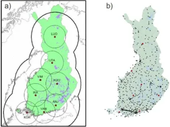
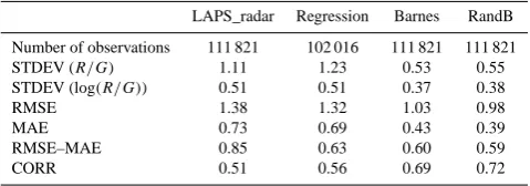
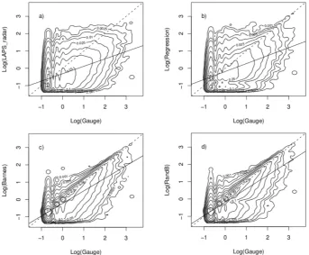
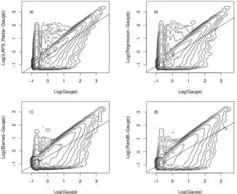
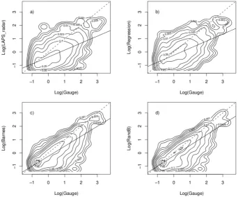
Precipitation accumulation analysis – assimilation of radar gauge measurements and validation of different methods
Full text
Figure

Related documents
The first version of the network device discovery module was essentially a wrapper for NetMRI. This module operates as follows: receive the input parameters, execute NetMRI
• Open up webpad and build web pages using original content (e.g. bio of superhero) in webpad • Create a website using webpad • Incorporate styles into the hacks •
RNA-Seq data of 17,471 transcripts from a total of 3,244 cancer samples across 26 different tissue types were compiled from in-house sequencing data and publically
Regional food hubs are touted as a way to help small and mid-sized food producers better access local markets and at the same time enable food purchasers to increase the amount
Bang Pa-In Summer Palace , located on the banks of the Pahsak River downstream from Ayuthaya, was built during the reign of King Rama IV. Buildings, in Thai, Italian,
In this study we evaluated relationships between running economy and anthropometrical and biomechanical measures, such as maximal thigh and calf circumference, length of the
The site is also open to potential impact to peat water levels and ground water from adjacent land management and other activities.. The land to the east is currently an open
