Text-Driven Toponym Resolution using Indirect Supervision
Michael Speriosu Jason Baldridge Department of Linguistics
University of Texas at Austin Austin, TX 78712 USA
{speriosu,jbaldrid}@utexas.edu
Abstract
Toponym resolvers identify the specific lo-cations referred to by ambiguous place-names in text. Most resolvers are based on heuristics using spatial relationships be-tween multiple toponyms in a document, or metadata such as population. This pa-per shows that text-driven disambiguation for toponyms is far more effective. We ex-ploit document-level geotags to indirectly generate training instances for text classi-fiers for toponym resolution, and show that textual cues can be straightforwardly in-tegrated with other commonly used ones. Results are given for both 19th century texts pertaining to the American Civil War and 20th century newswire articles.
1 Introduction
It has been estimated that at least half of the world’s stored knowledge, both printed and digi-tal, has geographic relevance, and that geographic information pervades many more aspects of hu-manity than previously thought (Petras, 2004; Skupin and Esperb´e, 2011). Thus, there is value in connecting linguistic references to places (e.g. placenames) to formal references to places (coor-dinates) (Hill, 2006). Allowing for the querying and exploration of knowledge in a geographically informed way requires more powerful tools than a keyword-based search can provide, in part due to the ambiguity of toponyms (placenames).
Toponym resolution is the task of disambiguat-ing toponyms in natural language contexts to geo-graphic locations (Leidner, 2008). It plays an es-sential role in automated geographic indexing and information retrieval. This is useful for histori-cal research that combines age-old geographic is-sues like territoriality with modern computational tools (Guldi, 2009), studies of the effect of
histor-ically recorded travel costs on the shaping of em-pires (Scheidel et al., 2012), and systems that con-vey the geographic content in news articles (Teitler et al., 2008; Sankaranarayanan et al., 2009) and microblogs (Gelernter and Mushegian, 2011).
Entity disambiguation systems such as those of Kulkarni et al. (2009) and Hoffart et al. (2011) disambiguate references to people and organiza-tions as well as locaorganiza-tions, but these systems do not take into account any features or measures unique to geography such as physical distance. Here we demonstrate the utility of incorporating distance measurements in toponym resolution systems.
Most work on toponym resolution relies on heuristics and hand-built rules. Some use sim-ple rules based on information from a gazetteer, such as population or administrative level (city, state, country, etc.), resolving every instance of the same toponym type to the same location re-gardless of context (Ladra et al., 2008). Others use relationships between multiple toponyms in a text (local or whole document) and look for con-tainment relationships, e.g. LondonandEngland
occurring in the same paragraph or as the bigram
London, England (Li et al., 2003; Amitay et al., 2004; Zong et al., 2005; Clough, 2005; Li, 2007; Volz et al., 2007; Jones et al., 2008; Buscaldi and Rosso, 2008; Grover et al., 2010). Still others first identify unambiguous toponyms and then disam-biguate other toponyms based on geopolitical re-lationships with or distances to the unambiguous ones (Ding et al., 2000). Many favor resolutions of toponyms within a local context or document that cover a smaller geographic area over those that are more dispersed (Rauch et al., 2003; Leidner, 2008; Grover et al., 2010; Loureiro et al., 2011; Zhang et al., 2012). Roberts et al. (2010) use relation-ships learned between people, organizations, and locations from Wikipedia to aid in toponym reso-lution when such named entities are present, but do not exploit any other textual context.
Most of these approaches suffer from a major weakness: they rely primarily on spatial relation-ships and metadata about locations (e.g., popu-lation). As such, they often require nearby ponyms (including unambiguous or containing to-ponyms) to resolve ambiguous ones. This reliance can result in poor coverage when the required in-formation is missing in the context or when a doc-ument mentions locations that are neither nearby geographically nor in a geopolitical relationship. There is a clear opportunity that most ignore: use non-toponym textual context. Spatially rel-evant words like downtown that are not explicit toponyms can be strong cues for resolution (Hol-lenstein and Purves, 2012). Furthermore, the con-nection between non-spatial words and locations has been successfully exploited in data-driven approaches to document geolocation (Eisenstein et al., 2010, 2011; Wing and Baldridge, 2011; Roller et al., 2012) and other tasks (Hao et al., 2010; Pang et al., 2011; Intagorn and Lerman, 2012; Hecht et al., 2012; Louwerse and Benesh, 2012; Adams and McKenzie, 2013).
In this paper, we learn resolvers that use all words in local or document context. For example, the wordlobsterappearing near the toponym Port-land indicates the location is Portland in Maine rather than Oregon or Michigan. Essentially, we learn a text classifier per toponym. There are no massive collections of toponyms labeled with lo-cations, so we train models indirectly using geo-tagged Wikipedia articles. Our results show these text classifiers are far more accurate than algo-rithms based on spatial proximity or metadata. Furthermore, they are straightforward to combine with such algorithms and lead to error reductions for documents that match those algorithms’ as-sumptions.
Our primary focus is toponym resolution, so we evaluate on toponyms identified by human anno-tators. However, it is important to consider the utility of an end-to-end toponym identification and resolution system, so we also demonstrate that performance is still strong when toponyms are de-tected with a standard named entity recognizer.
We have implemented all the models discussed in this paper in an open source software package called Fieldspring, which is available on GitHub:
http://github.com/utcompling/fieldspring
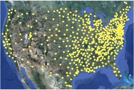
[image:2.595.307.526.62.208.2]Explicit instructions are provided for preparing data and running code to reproduce our results.
Figure 1: Points representing the United States.
2 Data
2.1 Gazetteer
Toponym resolvers need a gazetteer to obtain can-didate locations for each toponym. Additionally, many gazetteers include other information such as population and geopolitical hierarchy information. We use GEONAMES, a freely available gazetteer containing over eight million entries worldwide.1 Each location entry contains a name (sometimes more than one) and latitude/longitude coordinates. Entries also include the location’s administrative level (e.g. city or state) and its position in the geopolitical hierarchy of countries, states, etc.
GEONAMES gives the locations of regional items like states, provinces, and countries as single points. This is clearly problematic when we seek connections between words and locations: e.g. we might learn that many words associated with the USA are connected to a point in Kansas. To get around this, we represent regional locations as a set of points derived from the gazetteer. Since re-gional locations are named in the entries for loca-tions they contain, all localoca-tions contained in the region are extracted (in some cases over 100,000 of them) and thenk-means is run to find a smaller set of spatial centroids. These act as a tractable proxy for the spatial extent of the entire region. k is set to the number of 1◦ by 1◦grid cells covered by that region. Figure 1 shows the points com-puted for the United States.2 A nice property of this representation is that it does not involve re-gion shape files and the additional programming infrastructure they require.
1Downloaded April 16, 2013 from www.geonames.
org.
2The representation also contains three points each in
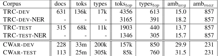
Corpus docs toks types tokstop typestop ambavg ambmax
TRC-DEV 631 136k 17k 4356 613 15.0 857
TRC-DEV-NER - - - 3165 391 18.2 857
TRC-TEST 315 68k 11k 1903 440 13.7 857
TRC-TEST-NER - - - 1346 305 15.7 857
CWAR-DEV 228 33m 200k 157k 850 29.9 231
[image:3.595.111.492.63.160.2]CWAR-TEST 113 25m 305k 85k 760 31.5 231
Table 1: Statistics of the corpora used for evaluation. Columns subscripted by top give figures for toponyms. The last two columns give the average number of candidate locations per toponym token and the number of candidate locations for the most ambiguous toponym.
A location for present purposes is thus a set of points on the earth’s surface. The distance be-tween two locations is computed as the great circle distance between the closest pair of representative points, one from each location.
2.2 Toponym Resolution Corpora
We need corpora with toponyms identified and re-solved by human annotators for evaluation. The TR-CONLL corpus (Leidner, 2008) contains 946 REUTERS news articles published in August 1996. It has about 204,000 words and articles range in length from a few hundred words to sev-eral thousand words. Each toponym in the corpus was identified and resolved by hand.3 We place every third article into a test portion (TRC-TEST) and the rest in a development portion. Since our methods do not learn from explicitly labeled to-ponyms, we do not need a training set.
The Perseus Civil War and 19th Century Amer-ican Collection (CWAR) contains 341 books (58 million words) written primarily about and during the American Civil War (Crane, 2000). Toponyms were annotated by a semi-automated process: a named entity recognizer identified toponyms, and then coordinates were assigned using simple rules and corrected by hand. We divide CWARinto de-velopment (CWAR-DEV) and test (CWAR-TEST) sets in the same way as TR-CONLL.
Table 1 gives statistics for both corpora, includ-ing the number and ambiguity of gold standard toponyms for both as well as NER identified
to-3We found several systematic types of errors in the
origi-nal TR-CONLL corpus, such as coordinates being swapped
for some locations and some longitudes being zero or the neg-ative of their correct values. We repaired many of these er-rors, though some more idiosyncratic mistakes remain. We, along with Jochen Leidner, will release this updated version shortly and will link to it from our Fieldspring GitHub page.
ponyms for TR-CONLL.4 We use the pre-trained English NER from the OpenNLP project.5
2.3 Geolocated Wikipedia Corpus
The GEOWIKI dataset contains over one million English articles from the February 11, 2012 dump of Wikipedia. Each article has human-annotated latitude/longitude coordinates. We divide the cor-pus into training (80%), development (10%), and test (10%) at random and perform preprocessing to remove markup in the same manner as Wing and Baldridge (2011). The training portion is used here to learn models for text-driven resolvers.
3 Toponym Resolvers
Given a set of toponyms provided via annotations or identified using NER, a resolver must select a candidate location for each toponym (or, in some cases, a resolver may abstain). Here, we describe baseline resolvers, a heuristic resolver based on the usual cues used in most toponym resolvers, and several text-driven resolvers. We also discuss combining heuristic and text-driven resolvers.
3.1 Baseline Resolvers
RANDOM For each toponym, the RANDOM re-solver randomly selects a location from those as-sociated in the gazetteer with that toponym.
POPULATION The POPULATION resolver se-lects the location with the greatest population for each toponym. It is generally quite effective, but when a toponym has several locations with large populations, it is often wrong. Also, it can only be used when such information is available, and it is
4States and countries are not annotated in CWAR, so we
do not evaluate end-to-end using NER plus toponym resolu-tion for it as there are many (falsely) false positives.
less effective if the population statistics are from a time period different from that of the corpus.
3.2 SPIDER
Leidner (2008) describes two general and useful
minimalityproperties of toponyms:
• one sense per discourse: multiple tokens of
a toponym in the same text generally do not refer to different locations in the same text
• spatial minimality: different toponyms in a
text tend refer to spatially near locations Many toponym resolvers exploit these (Smith and Crane, 2001; Rauch et al., 2003; Leidner, 2008; Grover et al., 2010; Loureiro et al., 2011; Zhang et al., 2012). Here, we define SPIDER (Spatial Prominence via Iterative Distance Evaluation and Reweighting) as a strong representative of such textually unaware approaches. In addition to cap-turing both minimality properties, it also identifies the relative prominence of the locations for each toponym in a given corpus.
SPIDER resolves each toponym by finding the location for each that minimizes the sum distance toalllocations forallother toponyms in the same document. On the first iteration, it tends to select locations that clump spatially: ifParisoccurs with
Dallas, it will choose Paris, Texas even though the topic may be a flight from Texas to France. Further iterations bring Paris, France into focus by captur-ing its prominence across the corpus. The key in-tuition is that most documents will discuss Paris, France and only a small portion of these mention places close to Paris, Texas; thus, Paris, France will be selected on the first iteration for many documents (though not for theDallasdocument). SPIDER thus assigns each candidate location a weight (initialized to 1.0), which is re-estimated on each iteration. The adjusted distance between two locations is computed as the great circle dis-tance divided by the product of the two locations’ weights. At the end of an iteration, each candi-date location’s weight is upcandi-dated to be the frac-tion of the times it was chosen times the number of candidates for that toponym. The weights are global, with one for each location in the gazetteer, so the same weight vector is used for each token of a given toponym on a given iteration.
For example, if after the first iteration Paris, France is chosen thrice, Paris, Texas once, and Paris, Arkansas never, the global weights of these locations are (3/4)∗3=2.25, (1/4)∗3=.75, and
(0/4)∗3=0, respectively (assume, for the exam-ple, there are no other locations namedParis). The sum of the weights remains equal to the number of candidate locations. The updated weights are used on the next iteration, so Paris, France will seem “closer” since any distance computed to it is divided by a number greater than one. Paris, Texas will seem somewhat further away, and Paris, Arkansas infinitely far away. The algorithm con-tinues for a fixed number of iterations or until the weights do not change more than some thresh-old. Here, we run SPIDER for 10 iterations; the weights have generally converged by this point.
When only one toponym is present in a doc-ument, we simply select the candidate with the greatest weight. When there is no such weight in-formation, such as when the toponym does not co-occur with other toponyms anywhere in the cor-pus, we select a candidate at random.
SPIDER captures prominence, but we stress it is not our main innovation: its purpose is to be a benchmark for text-driven resolvers to beat.
3.3 Text-Driven Resolvers
The text-driven resolvers presented in this section all use local context windows, document context, or both, to inform disambiguation.
TRIPDL We use a document geolocator trained on GEOWIKI’s document location labels. Others—such as Smith and Crane (2001)—have estimated a document-level location to inform toponym resolution, but ours is the first we are aware of to use training data from a different domain to build a document geolocator that uses all words (not only toponyms) to estimate a document’s location. We use the document geolo-cation method of Wing and Baldridge (2011). It discretizes the earth’s surface into 1◦ by 1◦ grid cells and assigns Kullback-Liebler divergences to each cell given a document, based on language models learned for each cell from geolocated Wikipedia articles. We obtain the probability of a cellcgiven a documentdby the standard method of exponentiating the negative KL-divergence and normalizing these values over all cells:
P(c|d) = Pexp(−KL(c, d)) c0exp(−KL(c0, d))
locations of tin documentdto be the portion of P(c|d)consistent with thet’s candidate locations:
PDL(l|t, d) =
P(cl|d) P
l0∈G(t)P(cl0|d)
whereG(t) is the set of the locations fortin the gazetteer, andclis the cell containingl. TRIPDL
(Toponym Resolution Informed by Predicted Doc-ument Locations) chooses the location that maxi-mizesPDL.
WISTR While TRIPDL uses an off-the-shelf document geolocator to capture the geographic gist of a document, WISTR (Wikipedia Indirectly Supervised Toponym Resolver) instead directly targets each toponym. It learns text classifiers based on local context window features trained on instances automatically extracted from GEOWIKI. To create the indirectly supervised training data for WISTR, the OpenNLP named entity recog-nizer detects toponyms in GEOWIKI, and can-didate locations for each toponym are retrieved from GEONAMES. Each toponym with a loca-tion within 10km of the document localoca-tion is con-sidered a mention of that location. For example, theEmpire State BuildingWikipedia article has a human-provided location label of (40.75,-73.99). The toponymNew Yorkis mentioned several times in the article, and GEONAMESlists aNew Yorkat (40.71,-74.01). These points are 4.8km apart, so each mention ofNew Yorkin the document is con-sidered a reference to New York City.
Next, context windows w of twenty words to each side of each toponym are extracted as fea-tures. The label for a training instance is the candidate location closest to the document loca-tion. We extract 1,489,428 such instances for to-ponyms relevant to our evaluation corpora. These instances are used to train logistic regression clas-sifiersP(l|t, w) for locationland toponymt. To disambiguate a new toponym, WISTR chooses the location that maximizes this probability.
Few such probabilistic toponym resolvers ex-ist in the literature. Li (2007) builds a probabil-ity distribution over locations for each toponym, but still relies on nearby toponyms that could refer to regions that contain that toponym and requires hand construction of distributions. Other learn-ing approaches to toponym resolution (e.g. Smith and Mann (2003)) require explicit unambiguous mentions likePortland, Maine to construct train-ing instances, while our data gathertrain-ing
methodol-ogy does not make such an assumption. Overell and R¨uger (2008) and Overell (2009) only use nearby toponyms as features. Mani et al. (2010) and Qin et al. (2010) use other word types but only in a local context, and they require toponym-labeled training data. Our approach makes use of all words in local and document context and re-quires no explicitly labeled toponym tokens.
TRAWL We bring TRIPDL, WISTR, and
standard toponym resolution cues about ad-ministrative levels together with TRAWL (To-ponym Resolution via Administrative levels and Wikipedia Locations). The general form of a prob-abilistic resolver that utilizes such information to select a locationˆlfor a toponymtin documentd
may be defined as
ˆ
l= arg maxlP(l, al|t, d).
wherealis the administrative level (country, state,
city) forl in the gazetteer. This captures the fact that countries (like Sudan) tend to be referred to more often than small cities (like Sudan, Texas). The above term is simplified as follows:
P(l, al|t, d) = P(al|t, d)P(l|al, t, d) ≈ P(al|t)P(l|t, d)
where we approximate the administrative level prediction as independent of the document, and the location as independent of administrative level. The latter term is then expressed as a linear combi-nation of the local context (WISTR) and the doc-ument context (TRIPDL):
P(l|t, d) =λtP(l|t, ct) + (1−λt)PDL(l|t, d).
λt, the weight of the local context distribution, is
set according to the confidence that a prediction based on local context is correct:
λt= f(ft()+t)C,
where f(t) is the fraction of training instances
of toponym t of all instances extracted from GEOWIKI.Cis set experimentally;C=.0001was the optimal value for CWAR-DEV. Intuitively, the largerC is, the greaterf(t)must be for the local
context to be trusted over the document context. We defineP(a|t), the administrative level
com-ponent, to be the fraction of representative points for a locationˆl out of the number of
representa-tives points for all candidate locationsl∈t, ||Rˆl||
P
where||Rl||is the number of representative points
ofl. This boosts states and countries since higher probability is assigned to locations with more points (and cities have just one point).
Taken together, the above definitions yield the TRAWL resolver, which selects the optimal can-didate locationˆlaccording to
ˆ
l= arg maxlP(al|t)(λtP(l|t, ct) + (1−λt)PDL(l|t, d)).
3.4 Combining Resolvers and Backoff
SPIDER begins with uniform weights for each candidate location of each toponym. WISTR and TRAWL both output distributions over these locations based on outside knowledge sources, and can be used as more informed initializa-tions of SPIDER than the uniform ones. We call these combinations WISTR+SPIDER and TRAWL+SPIDER.6
WISTR fails to predict when encountering a toponym it has not seen in the training data, and TRIPDL fails when a toponym only has locations in cells with no probability mass. TRAWL fails when both of these are true. In these cases, we select the candidate location geographically clos-est to the most likely cell according to TRIPDL’s P(c|d)distribution.
3.5 Document Size
For SPIDER, runtime is quadratic in the size of documents, so breaking up documents vastly reduces runtime. It also restricts the minimal-ity heuristic—appropriately—to smaller spans of text. For resolvers that take into account the sur-rounding document when determining how to re-solve a toponym, such as TRIPDL and TRAWL, it can often be beneficial to divide documents into smaller subdocuments in order to get a better esti-mate of the overall geographic prominence of the text surrounding a toponym, but at a more coarse-grained level than the local context models pro-vide. For these reasons, we simply divide each book in the CWAR corpus into small subdocu-ments of at most 20 sentences.
4 Evaluation
Many prior efforts use a simple accuracy metric: the fraction of toponyms whose predicted location
6We scale each toponym’s distribution as output by
WISTR or TRAWL by the number of candidate locations for that toponym, since the total weight for each toponym in SPIDER is the number of candidate locations, not 1.
is the same as the gold location. Such a met-ric can be problematic, however. The gazetteer used by a resolver may not contain, for a given toponym, a location whose latitude and longitude
exactlymatch the gold label for the toponym (Lei-dner, 2008). Also, some errors are worse than oth-ers, e.g. predicting a toponym’s location to be on the other side of the world versus predicting it to be a different city in the same country—accuracy does not reflect this difference.
We choose a metric that instead measures the distance between the correct and predicted loca-tion for each toponym and compute the mean and median of all such error distances. This is used in document geolocation work (Eisenstein et al., 2010, 2011; Wing and Baldridge, 2011; Roller et al., 2012) and is related to the root mean squared distance metric discussed by Leidner (2008).
It is important to understand performance on plain text (without gold toponyms), which is the typical use case for applications using toponym resolvers. Both the accuracy metric and the error-distance metric encounter problems when the set of predicted toponyms is not the same as the set of gold toponyms (regardless of locations), e.g. when a named entity recognizer is used to iden-tify toponyms. In this case, we can use precision and recall, where a true positive is defined as the prediction of a correctly identified toponym’s lo-cation to be as close as possible to its gold la-bel, given the gazetteer used. False positives oc-cur when the NER incorrectly predicts a toponym, and false negatives occur when it fails to predict a toponym identified by the annotator. When a cor-rectly identified toponym receives an incorrect lo-cation prediction, this counts as both a false nega-tive and a false posinega-tive. We primarily present re-sults from experiments with gold toponyms but in-clude an accuracy measure for comparability with results from experiments run on plain text with a named entity recognizer. This accuracy met-ric simply computes the fraction of toponyms that were resolved as close as possible to their gold la-bel given the gazetteer.
5 Results
Resolver TRC-TEST CWAR-TEST
Mean Med. A Mean Med. A
ORACLE 105 19.8 100.0 0.0 0.0 100.0
RANDOM 3915 1412 33.5 2389 1027 11.8
POPULATION 216 23.1 81.0 1749 0.0 59.7
SPIDER10 2180 30.9 55.7 266 0.0 57.5
TRIPDL 1494 29.3 62.0 847 0.0 51.5
WISTR 279 22.6 82.3 855 0.0 69.1
WISTR+SPIDER10 430 23.1 81.8 201 0.0 85.9
TRAWL 235 22.6 81.4 945 0.0 67.8
[image:7.595.133.465.61.215.2]TRAWL+SPIDER10 297 23.1 80.7 148 0.0 78.2
Table 2: Accuracy and error distance metrics on test sets with gold toponyms.
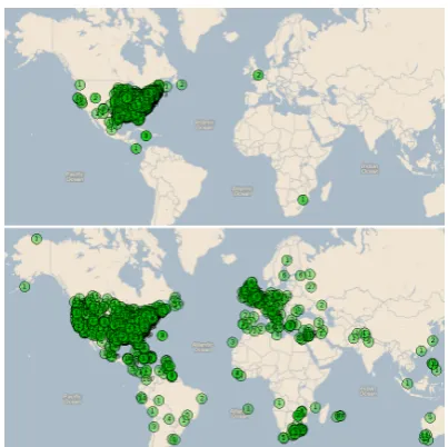
Figure 2: Visualization of how SPIDER clumps most predicted locations in the same region (above), on the CWAR-DEV corpus. TRAWL’s output (below) is much more dispersed.
from GEONAMES closest to the annotated loca-tion is always selected. The ORACLEmean and median error values on TR-CONLL are nonzero due to errors in the annotations and inconsisten-cies stemming from the fact that coordinates from GEONAMES were not used in the annotation of TR-CONLL.
On both datasets, SPIDER achieves errors and accuracies much better than RANDOM, validating the intuition that authors tend to discuss places near each other more often than not, while some locations are more prominent in a given corpus despite violating the minimality heuristic. The text-driven resolvers vastly outperform SPIDER, showing the effectiveness of textual cues for to-ponym resolution.
The local context resolver WISTR is very effective: it has the highest accuracy for TR-CONLL, though two other text-based re-solvers also beat the challenging POPULATION baseline’s accuracy. TRAWL achieves a better mean distance metric for TR-CONLL, and when used to seed SPIDER, it obtains the lowest mean error on CWAR by a large margin. SPIDER seeded with WISTR achieves the highest accu-racy on CWAR. The overall geographic scope of CWAR, a collection of documents about the American Civil War, is much smaller than that of TR-CONLL (articles about international events). This makes toponym resolution easier overall (es-pecially error distances) for minimality resolvers like SPIDER, which primarily seek tightly clus-tered sets of locations. This behavior is quite clear in visualizations of predicted locations such as Figure 2.
On the CWAR dataset, POPULATIONperforms relatively poorly, demonstrating the fragility of population-based decisions for working with his-torical corpora. (Also, we note that POPULATION is not a resolverper sesince it only ever predicts one location for a given toponym, regardless of context.)
Table 3 gives results on TRC-TESTwhen NER-identified toponyms are used. In this case, the ORACLEresults are less than 100% due to the lim-itations of the NER, and represent the best possible results given the NER we used.
[image:7.595.80.282.256.457.2]na-Resolver P R F
ORACLE 82.6 59.9 69.4
RANDOM 25.1 18.2 21.1
POPULATION 71.6 51.9 60.2
SPIDER10 40.5 29.4 34.1
TRIPDL 51.8 37.5 43.5
WISTR 73.9 53.6 62.1
WISTR+SPIDER10 73.2 53.1 61.5
TRAWL 72.5 52.5 60.9
[image:8.595.79.285.62.200.2]TRAWL+SPIDER10 72.0 52.2 60.5
Table 3: Precision, recall, and F-score of resolvers on TRC-TESTwith NER-identified toponyms.
ture of its training data, and many more local con-text training instances were extracted from com-mon toponyms than from rare ones in Wikipedia. Thus, our model that usesonlythese local context models does best when running on NER-identified toponyms. We also measured the mean and me-dian error distance for toponyms correctly identi-fied by the named entity recognizer, and found that they tended to be 50-200km worse than for gold toponyms. This also makes sense given the named entity recognizer’s tendency to detect common to-ponyms: common toponyms tend to be more am-biguous than others.
Results on TR-CONLL indicate much higher performance than the resolvers presented by Lei-dner (2008), whose F-scores do not exceed 36.5% with either gold or NER toponyms.7 TRC-TEST is a subset of the documents Leidner uses (he did not split development and test data), but the results still come from overlapping data. The most direct comparison is SPIDER’s F-score of 39.7% com-pared to his LSW03 algorithm’s 35.6% (both are minimality resolvers). However, our evaluation is more penalized since SPIDER loses precision for NER’s false positives (JackLondonas a location) while Leidner only evaluated on actual locations. It thus seems fair to conclude that the text-driven classifiers, with F-scores in the mid-50’s, are much more accurate on the corpus than previous work.
6 Error Analysis
Table 4 shows the ten toponyms that caused the greatest total error distances from TRC-DEVwith gold toponyms when resolved by TRAWL, the re-solver that achieves the lowest mean error on that
7Leidner (2008) reports precision, recall, and F-score
val-ues even with gold toponyms, since his resolvers can abstain.
dataset among all our resolvers.
Washington, the toponym contributing the most total error, is a typical example of a toponym that is difficult to resolve, as there are two very promi-nent locations within the United States with the name. Choosing one when the other is correct re-sults in an error of over 4000 kilometers. This oc-curs, for example, when TRAWL chooses Wash-ington state in the phrase Israel’s ambassador to Washington, where more knowledge about the status of Washington, D.C. as the political cen-ter of the United States (e.g. in the form of more or better contextual training instances) could over-turn the administrative level component’s prefer-ence for states.
An instance of Californiain a baseball-related news article is incorrectly predicted to be the town California, Pennsylvania. The context is: ...New York starter Jimmy Key left the game in the first inning after Seattle shortstop Alex Rodriguez lined a shot off his left elbow. The Yankees have lost 12 of their last 19 games and their lead in the AL East over Baltimore fell to five games. At Califor-nia, Tim Wakefield pitched a six-hitter for his third complete game of the season and Mo Vaughn and Troy O’Leary hit solo home runs in the second in-ning as the surging Boston Red Sox won their third straight 4-1 over the California Angels. Boston has won seven of eight and is 20-6... The pres-ence of many east coast cues—both toponym and otherwise—make it unsurprising that the resolver would predict California, Pennsylvania despite the administrative level component’s heavier weight-ing of the state.
The average errors for the toponyms Australia
andRussiaare fairly small and stem from differ-ences in how countries are represented across dif-ferent gazetteers, not true incorrect predictions.
Toponym N Mean Total Washington 25 3229 80717
Gaza 12 5936 71234
California 8 5475 43797 Montana 3 11635 34905
WA 3 11221 33662
NZ 2 14068 28136
Australia 88 280 24600 Russia 72 260 18712
OR 2 9242 18484
[image:9.595.98.266.60.213.2]Sydney 12 1422 17067
Table 4: Toponyms with the greatest total error distances in kilometers from TRC-DEVwith gold toponyms resolved by TRAWL. N is the number of instances, and the mean error for each toponym type is also given.
Toponym N Mean Total
Mexico 1398 2963 4142102 Jackson 2485 1210 3007541 Monterey 353 2392 844221 Haymarket 41 15663 642170 McMinnville 145 3307 479446 Alexandria 1434 314 450863 Eastport 184 2109 388000 Lexington 796 442 351684
Winton 21 15881 333499
Clinton 170 1401 238241
Table 5: Top errors from CWAR-DEVresolved by TRAWL+SPIDER.
simply the result of many American towns sharing the same names and a lack of clear disambiguating context.
7 Conclusion
Our text-driven resolvers prove highly effective for both modern day newswire texts and 19th cen-tury texts pertaining to the Civil War. They eas-ily outperform standard minimality toponym re-solvers, but can also be combined with them. This strategy works particularly well when predicting toponyms on a corpus with relatively restricted geographic extents. Performance remains good when resolving toponyms identified automatically, indicating that end-to-end systems based on our models may improve the experience of digital hu-manities scholars interested in finding and visual-izing toponyms in large corpora.
Acknowledgements
We thank: the three anonymous reviewers, Grant DeLozier, and the UT Austin Natural Language Learning reading group, for their helpful feed-back; Ben Wing, for his document geoloca-tion software; Jochen Leidner, for providing the TR-CONLL corpus as well as feedback on earlier versions of this paper; and Scott Nesbit, for pro-viding the annotations for the CWARcorpus. This research was supported by a grant from the Morris Memorial Trust Fund of the New York Commu-nity Trust.
References
B. Adams and G. McKenzie. Inferring thematic places from spatially referenced natural lan-guage descriptions.Crowdsourcing Geographic Knowledge, pages 201–221, 2013.
E. Amitay, N. Har’El, R. Sivan, and A. Soffer. Web-a-Where: geotagging web content. In Pro-ceedings of the 27th annual international ACM SIGIR conference on Research and development in information retrieval, pages 273–280, 2004. D. Buscaldi and P. Rosso. A conceptual
density-based approach for the disambiguation of to-ponyms.International Journal of Geographical Information Science, 22(3):301–313, 2008. P. Clough. Extracting metadata for
spatially-aware information retrieval on the internet. In
Proceedings of the 2005 workshop on Ge-ographic information retrieval, pages 25–30. ACM, 2005.
G. Crane. The Perseus Digital Library, 2000. URL
http://www.perseus.tufts.edu. J. Ding, L. Gravano, and N. Shivakumar.
Comput-ing geographical scopes of web resources. In
Proceedings of the 26th International Confer-ence on Very Large Data Bases, pages 545–556, 2000.
J. Eisenstein, B. O’Connor, N. Smith, and E. Xing. A latent variable model for geographic lexical variation. In Proceedings of the 2010 Con-ference on Empirical Methods in Natural Lan-guage Processing, pages 1277–1287, 2010. J. Eisenstein, A. Ahmed, and E. Xing. Sparse
[image:9.595.83.282.306.456.2]J. Gelernter and N. Mushegian. Geo-parsing mes-sages from microtext. Transactions in GIS, 15 (6):753–773, 2011.
C. Grover, R. Tobin, K. Byrne, M. Woollard, J. Reid, S. Dunn, and J. Ball. Use of the Ed-inburgh geoparser for georeferencing digitized historical collections. Philosophical Transac-tions of the Royal Society A: Mathematical, Physical and Engineering Sciences, 368(1925): 3875–3889, 2010.
J. Guldi. The spatial turn. Spatial Humanities: a Project of the Institute for Enabling, 2009. Q. Hao, R. Cai, C. Wang, R. Xiao, J. Yang,
Y. Pang, and L. Zhang. Equip tourists with knowledge mined from travelogues. In Pro-ceedings of the 19th international conference on World wide web, pages 401–410, 2010.
B. Hecht, S. Carton, M. Quaderi, J. Sch¨oning, M. Raubal, D. Gergle, and D. Downey. Ex-planatory semantic relatedness and explicit spa-tialization for exploratory search. In Proceed-ings of the 35th international ACM SIGIR con-ference on Research and development in infor-mation retrieval, pages 415–424. ACM, 2012. L. Hill. Georeferencing: The Geographic
Associ-ations of Information. MIT Press, 2006. J. Hoffart, M. Yosef, I. Bordino, H. F¨urstenau,
M. Pinkal, M. Spaniol, B. Taneva, S. Thater, and G. Weikum. Robust disambiguation of named entities in text. In Proceedings of the Con-ference on Empirical Methods in Natural Lan-guage Processing, pages 782–792. Association for Computational Linguistics, 2011.
L. Hollenstein and R. Purves. Exploring place through user-generated content: Using Flickr tags to describe city cores. Journal of Spatial Information Science, (1):21–48, 2012.
S. Intagorn and K. Lerman. A probabilistic ap-proach to mining geospatial knowledge from social annotations. In Conference on Infor-mation and Knowledge Management (CIKM), 2012.
C. Jones, R. Purves, P. Clough, and H. Joho. Mod-elling vague places with knowledge from the web. International Journal of Geographical In-formation Science, 2008.
S. Kulkarni, A. Singh, G. Ramakrishnan, and S. Chakrabarti. Collective annotation of Wikipedia entities in web text. InProceedings
of the 15th ACM SIGKDD international confer-ence on Knowledge discovery and data mining, pages 457–466. ACM, 2009.
S. Ladra, M. Luaces, O. Pedreira, and D. Seco. A toponym resolution service following the OGC WPS standard. InWeb and Wireless Geograph-ical Information Systems, volume 5373, pages 75–85. 2008.
J. Leidner. Toponym resolution in text: Anno-tation, Evaluation and Applications of Spatial Grounding of Place Names. Universal Press, Boca Raton, FL, USA, 2008.
H. Li, R. Srihari, C. Niu, and W. Li. InfoXtract lo-cation normalization: a hybrid approach to geo-graphic references in information extraction. In
Proceedings of the HLT-NAACL 2003 workshop on Analysis of geographic references - Volume 1, pages 39–44, 2003.
Y. Li. Probabilistic toponym resolution and geo-graphic indexing and querying. Master’s thesis, The University of Melbourne, Melbourne, Aus-tralia, 2007.
V. Loureiro, I. Anast´acio, and B. Martins. Learn-ing to resolve geographical and temporal ref-erences in text. In Proceedings of the 19th ACM SIGSPATIAL International Conference on Advances in Geographic Information Systems, pages 349–352, 2011.
M. Louwerse and N. Benesh. Representing spatial structure through maps and language: Lord of the Rings encodes the spatial structure of Mid-dle Earth. Cognitive science, 36(8):1556–1569, 2012.
I. Mani, C. Doran, D. Harris, J. Hitzeman, R. Quimby, J. Richer, B. Wellner, S. Mardis, and S. Clancy. SpatialML: annotation scheme, resources, and evaluation. Language Resources and Evaluation, 44(3):263–280, 2010.
S. Overell. Geographic Information Retrieval: Classification, Disambiguation and Modelling. PhD thesis, Imperial College London, 2009. S. Overell and S. R¨uger. Using co-occurrence
models for placename disambiguation. Inter-national Journal of Geographical Information Science, 22:265–287, 2008.
pho-tos. Computer Vision and Image Understand-ing, 115(3):352 – 363, 2011.
V. Petras. Statistical analysis of geographic and language clues in the MARC record. Technical report, The University of California at Berkeley, 2004.
T. Qin, R. Xiao, L. Fang, X. Xie, and L. Zhang. An efficient location extraction algorithm by leveraging web contextual information. In Pro-ceedings of the 18th SIGSPATIAL International Conference on Advances in Geographic Infor-mation Systems, pages 53–60. ACM, 2010. E. Rauch, M. Bukatin, and K. Baker. A
confidence-based framework for disambiguat-ing geographic terms. In Proceedings of the HLT-NAACL 2003 workshop on Analysis of ge-ographic references - Volume 1, pages 50–54, 2003.
K. Roberts, C. Bejan, and S. Harabagiu. Toponym disambiguation using events. InProceedings of the 23rd International Florida Artificial Intelli-gence Research Society Conference, pages 271– 276, 2010.
S. Roller, M. Speriosu, S. Rallapalli, B. Wing, and J. Baldridge. Supervised text-based geolocation using language models on an adaptive grid. In
Proceedings of EMNLP 2012, 2012.
J. Sankaranarayanan, H. Samet, B. Teitler, M. Lieberman, and J. Sperling. TwitterStand: news in tweets. In Proceedings of the 17th ACM SIGSPATIAL International Conference on Advances in Geographic Information Systems, pages 42–51, 2009.
W. Scheidel, E. Meeks, and J. Weiland. ORBIS: The Stanford geospatial network model of the roman world. 2012.
A. Skupin and A. Esperb´e. An alternative map of the United States based on ann-dimensional model of geographic space. Journal of Vi-sual Languages & Computing, 22(4):290–304, 2011.
D. Smith and G. Crane. Disambiguating geo-graphic names in a historical digital library. In
Proceedings of the 5th European Conference on Research and Advanced Technology for Digital Libraries, pages 127–136, 2001.
D. Smith and G. Mann. Bootstrapping toponym classifiers. In Proceedings of the HLT-NAACL
2003 workshop on Analysis of geographic ref-erences - Volume 1, pages 45–49, 2003.
B. Teitler, M. Lieberman, D. Panozzo, J. Sankara-narayanan, H. Samet, and J. Sperling. News-Stand: a new view on news. InProceedings of the 16th ACM SIGSPATIAL international con-ference on Advances in geographic information systems, page 18. ACM, 2008.
R. Volz, J. Kleb, and W. Mueller. Towards ontology-based disambiguation of geographical identifiers. InProceedings of the 16th Interna-tional Conference on World Wide Web, 2007. B. Wing and J. Baldridge. Simple supervised
doc-ument geolocation with geodesic grids. In Pro-ceedings of the 49th Annual Meeting of the As-sociation for Computational Linguistics: Hu-man Language Technologies, pages 955–964, 2011.
Q. Zhang, P. Jin, S. Lin, and L. Yue. Extracting focused locations for web pages. In Web-Age Information Management, volume 7142, pages 76–89. 2012.