ISSN Print: 2158-706X
DOI: 10.4236/nr.2019.1010025 Oct. 11, 2019 367 Natural Resources
Land Use/Land Cover Dynamics and
Anthropogenic Driving Factors in Lake
Baringo Catchment, Rift Valley, Kenya
Molly Ochuka
1,2*, Chris Ikporukpo
2, Yahaya Mijinyawa
3, George Ogendi
41Department of Agricultural and Environmental Engineering, Pan African University, Life and Earth Sciences Institute, University of Ibadan, Ibadan, Nigeria
2Department of Geography, University of Ibadan, Ibadan, Nigeria
3Department of Agricultural and Environmental Engineering, University of Ibadan, Ibadan, Nigeria 4Department of Environmental Science, Egerton University, Njoro, Kenya
Abstract
Anthropogenic activities have altered land cover in Lake Baringo Catchment contributing to increased erosion and sediment transport into water bodies. The study aims at analyzing the spatial and temporal Land Use and Land Cover Changes (LULCC) changes from 1988 to 2018 and to identify the main driving forces. GIS and Remote Sensing techniques, interviews and field ob-servations were used to analyze the changes and drivers of LULCC from 1988-2018. The satellite imagery was selected from SPOT Image for the years 1988, 1998, 2008 and 2018. Environment for Visualizing Images (ENVI 5.3) was used to perform image analysis and classification. The catchment was classified into six major LULC classes which are water bodies, settlement, rangeland, vegetation, farmland and bare land. The results revealed that, be-tween the years 1988-1998, and 1998-2008, water bodies decreased by 2.77% and 0.76% respectively. However, during the years 2008-2018, water body coverage increased by 1.87%. Forest cover steadily increased from 1988-2018. From 1988-1998, 1998-2008 and 2008-2018, farmland was increased by 21.11%, 3.21% and 1.7% while rangeland decreased continuously between the years 1988-1998, 1998-2008 and 2008-2018 in the order 15.14%, 4.13% and 3.74% respectively. Similarly, bare land also reduced by 1.75%, 1.04% and 0.99% between the years 1988-1998, 1998-2008 and 2008-2018 respectively. The findings attributed LULCC to rapid population growth, deforestation, poor farming practices and overstocking. The results will provide valuable information to the relevant stakeholders to formulate evidence-based land use management strategies in order to achieve ecological integrity.
How to cite this paper: Ochuka, M., Ik-porukpo, C., Mijinyawa, Y. and Ogendi, G. (2019) Land Use/Land Cover Dynamics and Anthropogenic Driving Factors in Lake Ba-ringo Catchment, Rift Valley, Kenya. Nat-ural Resources, 10, 367-389.
https://doi.org/10.4236/nr.2019.1010025
Received: August 19, 2019 Accepted: October 8, 2019 Published: October 11, 2019
Copyright © 2019 by author(s) and Scientific Research Publishing Inc. This work is licensed under the Creative Commons Attribution International License (CC BY 4.0).
DOI: 10.4236/nr.2019.1010025 368 Natural Resources
Keywords
Land Use/Land Cover, Catchment, Anthropogenic Factors, Land Management
1. Introduction
Land Use and Land Cover Change (LULCC) is a major component of global
environment change [1]. It is also an important aspect of human alteration of
the Earth System functioning [2]. Land cover can be described by the biophysical
features of the land surface such as forests while land use refers to the human
modification of natural environment such as farming [3] [4]. There has been a
rapid land use change in East Africa [5]. Many parts of this region are
expe-riencing these changes at varied spatial and temporal scales anthropogenic
activ-ities [6]. The functioning of Lake Baringo is threatened by degradation despite
being a source of livelihood to the community [7]. The driving forces of LULCC
vary from one place to the other [8]. Driving processes are reflected through the
transition of land use and land cover [9]. Human alteration of the environment
has been existing for thousands of years. However, the degree and intensity of
LULCC are far-off greater now than it was in the past [10]. Variation in social,
political, and economic characteristics defines the rate at which humans can
transform the condition of their environment [11]. Land cover change reveals
the dimension of human activities in a given environment [12]. In East Africa,
Land uses have transformed the natural environment into settlements
agricul-tural lands, grazing lands, and urban centers [5]. In Kenya, the growing
popula-tion over the years has exerted pressure on the land resources where approx-imately 75% of the population participates in agriculture but only 20% of its land
is arable [13]. Lake Baringo ecosystem is a reflection of environments
under-going remarkable land cover change due to several reasons [6]. The pastoral
communities in catchment have destroyed the vegetation cover [14]. They keep
large numbers of cattle, which overgrazes the catchment vegetation leading to enhanced soil erosion, sedimentation in streams and the lake, and frequent flash
floods [15]. The increasing human populations in the catchments have also led
to the uncontrolled destruction of riparian forest, coupled with foraging by
li-vestock ultimately leading to soil erosion and sedimentation [16]. The Changes
in land cover can widespread effects at local, regional and global scales [17]. Although practices vary across the world, their eventual consequences are the same [18]. Land use and land cover changes deteriorate the natural ecosystems
consequently leading to environmental hazards [19]. Increased population growth
and increasing demand for resources have contributed to unique land use
cate-gories which are attributed to soil degradation and ecosystem services [2], and
alteration of the hydrological systems [20]. Kenya’s Rift Valley has been
under-going rapid land cover change for the past two decades, which has resulted in
ecolog-DOI: 10.4236/nr.2019.1010025 369 Natural Resources ical challenges such as Land cover changes, Biodiversity loss, Habitat
degrada-tion and Algal blooms [22]. Altered land cover in Lake Baringo catchment has
led to the increased erosion and sediment transport to the lake consequently
changing the hydrologic pattern [23]. Whenever it rains around the lake there
are flush-floods from inflowing rivers due to poor farming practices on the
Tur-gen hills surrounding the lake [24]. Land use studies are significant in
under-standing hydrological processes in the watershed [25]. LULCC can mirror the
pattern of human land use in a region, and plays an important role in water and
soil conservation [26]. Understanding how such human factors interact in
driv-ing land use will upgrade human understanddriv-ing and responses to environmental
changes [4]. Knowledge of the distribution of land use and land cover is
funda-mental in environfunda-mental planning projects implementation and management
[27]. The primary objective of this study is to analyse the spatial and temporal
changes of Land use/land cover in Lake Baringo Catchment from 1988 to 2018 and to identify the main driving forces. Therefore, information on LULCC vital in policy formulation and making informed decision for sustainable natural re-sources management in Lake Baringo Catchment.
2. Materials and Methods
2.1. Study Area
Lake Baringo is one of the two freshwater lakes in the Rift Valley floor in Kenya. Lake Baringo is an internationally recognized important world Ramsar site. It is located in the Eastern arm of the Great Rift Valley (00˚30'N and 00˚45'N, and
36˚00'E and 36˚10'E) and at an elevation of about 970 meters (Figure 1). It has a
surface area of about 130 km2 which may rise to 168 km2 during the rainy
sea-sons and an altitude of about 1100 m.a.s.l. It drains a total area of 6820 km2. The
lake’s water catchment includes the Mau Hills and Tugen Hills. Perkerra and Molo are the perennial rivers that drain into the lake whereas seasonal rivers in-clude Endau, Chemeron Ol Arabel, Makutan and Tangulbei. It has no visible outlet and it is believed to have an underground seepage at Kapedo to the north and the water flows out as geysers and hot springs into Lake Turkana. The area receives an annual rainfall that ranges from 450 from 900 mm. It is characterized by a very high annual evaporation rate that ranges from 1650 from 2300 mm
[28]. The long rains occur in the months of April to August, whereas the short
DOI: 10.4236/nr.2019.1010025 370 Natural Resources Source: Researchers Survey.
Figure 1. Lake Baringo Catchment.
cultural value. Il Chamus inhabits the lowland close to Lake Baringo. They com-bine rain-fed cultivation with some irrigations, but are mainly livestock keepers as well. Tugen originated in the surrounding uplands, but have progressively expanded down into the valley floor. Lake Baringo is a critical habitat and refuge for more than 500 species of birds and fauna, seven species of fresh water fish. In addition, it is a habitat for several species of animals including the hippo, Croco-diles and many more freshwater organisms. The lake has major seven islands namely Ruko, Rongena, Linage, Samatian, Olkokwa, Parmalok and the Devil’s Island. Ol-Kokwa is the largest Island. It has several hot springs and geysers. Ruko, on the other hand, is a park having a variety of wildlife such as Zebra and Giraffe. These have promoted ecotourism and the expansion in hotel industry.
2.2. Data Acquisition
DOI: 10.4236/nr.2019.1010025 371 Natural Resources image matching, classification and processing. The satellite imagery was selected from SPOT Image for the years 1988, 1998, 2008 and 2018. Spot Images were used because they have high resolution and are already orthorectified. They offer an optimum combination of resolution and coverage. Topographical maps of the study area supplemented with Google map and Google Earth representing the Lake Baringo Watershed were important in identifying Ground Control Points (GCPs). GPS measurements and orientation were taken using Han-dy-android powered GPS with accuracy of 2 m. The Ground Control Points helped during ground truthing as well as creating training sites used in super-vised classification.
Socio-economic data including livelihood activities and land use change driv-ing factors were obtained through field interviews and observations.
2.3. Data Analysis
1) Image enhancementImage preprocessing was done using ENVI 5.3 because of its wide range of tools for image preprocessing, flexible in image display and the ability to process large multispectral remote sensing data. At this stage, visual quality of the image was enhanced by manipulating digital pixel values through a process known as contrast enhancement. The goal of image enhancement is to improve the visual interpretability of an image by increasing the apparent distinction between the features. Brightness differences of the image were improved uniformly by adjust-ing the bright and dark pixels so that the intermediate values have better contrast.
2) Layer stacking
Layer stacking were carried out on the downloaded data to acquire Mul-ti-band composite images. The SPOT Images were obtained in their single bands separately. These constituent bands are stored in a Tagged Image File Format (TIFF) format which are not as useful individually as when stacked together to form a single image. Each band provides record of amount of energy reflected in a specific portion of electro-magnetic spectrum. Therefore assigning band 4 with a red color, band 3 with green color and band 2 with blue based on false color composite scheme which helped in understanding changes in vegetation over time and visually interpret changes in land use.
3) Image clipping
Image clipping was carried to help reduce the whole image to a smaller more workable Area of Interest (AOI) showing Lake Baringo Watershed. This helped reduce the computation time of the processes and eliminate the production of excess data that unnecessarily lengthens the classification process. This was car-ried out using the extract by mask tool found in ArcGIS 10.4 software using the Lake Baringo watershed extend shape file.
4) Image Classification
DOI: 10.4236/nr.2019.1010025 372 Natural Resources SPOT 3, SPOT 5 and SPOT 7.ENVI 5.3 Image processing software was used for the development of land cover and land use classes and subsequently for change detection analysis of the study area. ArcGIS 10.5 was used for displaying and sub-sequent processing and enhancement of the images. It was also used for clipping out the area of interest from the images using topographical maps of the area and designing all maps as a result of Land use and Land cover classification outputs.
Supervised classification based on Maximum Likelihood Classifier (MLC) was used for classification of the image. The training sites were representative sample of different land cover type. Hand-held android powered Global Positioning Sys-tem (GPS) helped in selecting ground control points which formed basis for training sites. MLC uses probability of a pixel in a given training site of a given land cover class if the probability of that pixel is larger than the probability of its occurrence in any other class. if and only if the probability of that pixel is larger than the probability of its occurrence in any other class. The advantage of MLC over parallelepiped and minimum-distance methods of supervised classification is the use of mean and standard deviation in assigning pixels giving the results better accuracy and reliability. The process of classification on ENVI involved collecting classes from the image by capturing at least 3 ROIs within a certain class for the best representation of the spectral signature within that class. It was followed by clicking within the zoom window to draw the polygons. Training sites helped in the drawing of polygons and this enhanced accuracy in class identification.
After collecting at least 3 ROIs of the first class, a New Region in the ROI Tool was selected to start collecting another class. This was followed by classifying the classes. Once the classification was completed, a new classification image ap-peared. Maximum Likelihood method, a type of supervised classification, as-sumed that the statistics for each class in each band are normally distributed and calculates the probability that a given pixel belongs to a specific class. Each pixel is assigned to the class that has the highest probability. A total of 6 land cover classes were considered namely; Water Bodies, Bare areas Forest/vegetation, Set-tlements, and Rangeland.
5) Training signatures
Generation of training signatures based on the training sets was used to create class signatures. This helped in identifying pixels with similar spectral reflec-tance and assigned them appropriate information classes.
6) Accuracy assessment
DOI: 10.4236/nr.2019.1010025 373 Natural Resources used in accuracy by comparing them to classified images. They were used as ref-erence data to generate data.
7) Spatial-Temporal Changes
This analysis was carried out to find the rate and pattern of LULCC. This was attained by subtracting the total area in 2018 from the total area in 1988. The resultant figure is multiplied by 100 to obtain the rate of change that occurred, which could be positive (increase) or negative (decrease).
3. Results and Discussion
3.1. Analysis of Land Use and Land Cover Types
The results of the image classification identified six major land uses including water bodies, settlement, Range land, vegetation, farmland and bare land as
shown in Table 1. Results from the classified image show that rangeland
domi-nated the catchment with 104,889.74 ha representing 47.25% of the land as
de-picted in Figure 2 and Table 1. Water Bodies, settlement and forest cover also
covered the better part of the catchment constituting 21,632.42 ha (9.74%), 21,325.75 ha (9.61%) and 18,635.93 ha (8.4%) respectively. Farm land and Bare land Covered a small part of the catchment with 4256.27 ha (21.74%) and
[image:7.595.57.540.393.535.2]7245.41 (3.26%) ha respectively as displayed in Table 2. The changed land cover
Table 1. Land Use and Land Cover Changes in Lake Baringo Catchment, from 1988-2018.
Land Use and Land Cover of Lake Baringo Catchment Area in Ha
1988 Cover (%) 1988 Area in Ha 1998 Cover (%) 1998 Area in Ha 2008 Cover (%) 2008 Area in Ha 2018 Cover (%) 2018
Water Bodies 21,632.42 9.74 20,821.62 9.38 19,124.62 8.62 23,285.15 10.49
Settlement 21,325.75 9.61 26,247.37 11.82 29,758.35 13.41 31,857.64 14.35
Rangeland 104,889.74 47.25 97,215.91 43.79 88,040.54 39.66 79,747.41 35.92
Forest/Vegetation 18,635.93 8.4 20,365.43 9.17 22,896.21 10.31 23,356.36 10.52
Farmland 4256.27 21.74 52,178.41 23.51 59,320.27 26.72 63,085.76 28.42
Bare Land 7245.41 3.26 5156.78 2.32 2845.53 1.28 653.2 0.29
Source: Researcher’s analysis, 2018.
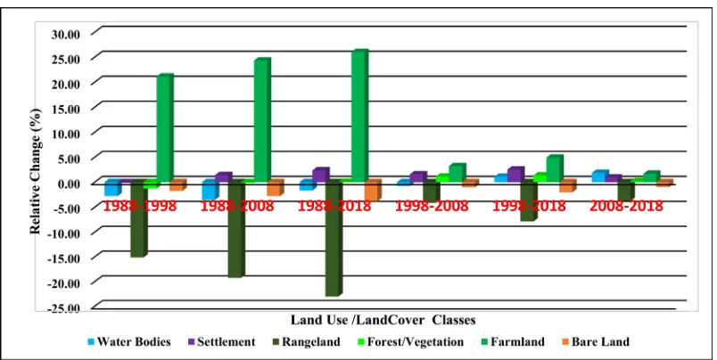
Table 2. Percentage change in Land Use Land Cover.
Classes Land Use/Land Cover Changes during 1988-2018.
1988-1998 (%) 1988-2008 (%) 1988-2018 (%) 1998-2008 (%) 1998-2018 (%) 2008-2018 (%)
Water Bodies −2.77 −3.53 −1.66 −0.76 1.11 1.87
Settlement 2.22 1.43 2.37 1.59 2.53 0.94
Rangeland −15.14 −19.27 −23.01 −4.13 −7.87 −3.74
Forest/Vegetation 1.30 −0.16 0.05 1.14 1.35 0.21
Farmland 21.11 24.33 26.03 3.21 4.91 1.70
Bare Land −1.75 −2.79 −3.78 −1.04 −2.03 −0.99
[image:7.595.58.540.586.711.2]DOI: 10.4236/nr.2019.1010025 374 Natural Resources Source: Researcher’s analysis, 2018.
DOI: 10.4236/nr.2019.1010025 375 Natural Resources is in many respects an effect of the increased population combined with the large social importance of livestock [23].
3.2. Spatial Temporal and Use and Land Cover Change Analysis
from 1988-1998
The results revealed that, between the years 1988-1998 water bodies decreased by
2.77% from 21,632.42 ha to 20,821.62 ha as displayed in Figure 3. This can be
attributed to the increased irrigation activities in the catchment and high solar radiation considering the fact that the catchment is located in a semi-arid land. Water diversions for irrigation also have been made from the Perkerra, Molo, Ol
Arabel Rivers have also contributed to reduced stream flow [15]. Settlement
in-creased by 2.22% from 21,325.75 ha to 26,247.37 ha. The increase in settlement may be associated with population growth as well as industrial development during this period. The catchment is gradually expanding into urban due to the development of industries such as sisal industries and tourism. Despite increas-ing economic development through tertiary industry in remote area, ecotourism
also contributes to intensive land use [29]. A similar study in Modjo Watershed,
Ethiopia revealed that increased settlement is one of the factors that heavy
impacts the land [30]. Rangeland decreased by 15.14% from 104,889.74 ha to
97,215.91 ha. This can be attributed to the increased agricultural activities in the catchment such as Perkerra irrigation scheme and large scale sisal plantation in
Mogotio as shown in Plate 1. Lake Baringo being a pastoralist community,
overgrazing can be attributed to the decline in rangeland cover. Degradation of rangeland resulted from overgrazing in semi-arid mountainous watershed of
High Atlas, Morocco [31]. The transformation and disintegration semi-natural
rangelands results to biodiversity loss [32]. Forest/Vegetation increased by 1.30%
from 18,635.93 ha to 20,365.43 ha. Forest covers slightly increased in the catch-ment during this period due to the introduction of Prosopis Juliflora after being introduced into the rangelands of Baringo in the early 1980s through the efforts of the “Fuel wood/Afforestation Extension in Baringo” project, a joint initiative of the Food and Agriculture Organization (FAO) and the Government of Kenya
[33]. Baringo was severely degraded, after prolonged droughts in the 1970s, and
this called for the urgent need for rehabilitation through drought tolerant species
[34]. Although this invasive species has dominated the catchment chocking
oth-er natural vegetation [25], made Similar observation in Keleta watershed, Awash
DOI: 10.4236/nr.2019.1010025 376 Natural Resources Source: Researcher’s analysis, 2018.
DOI: 10.4236/nr.2019.1010025 377 Natural Resources
Plate 1. Large Scale irrigation farming at Perkerra and Large Scale sisal plantation in Mogotio.
management of the ecological environment of the Lake Baringo Catchment has actually had a positive effect Rapid population growth put pressure on demand for food thus increasing the farming activities. Population as a driving factor is
partially accountable for the extension of farmlands and settlement [35].
Ac-cording to [10], observed increase in agricultural area from1992 to 2012 in
Isla-mabad Pakistan is driven was by economic development, climate change and population growth. Bare Land decreased by 1.75% from 7245.41 ha to 5156.78 ha and this can be attributed to increased farming activities, settlement and re-afforestation. A previous study assessing the relationship between water qual-ity parameters and changes in land use patterns in the Upper Manyame River, Zimbabwe revealed bare land decrease between years 1984 to 2011 by 31.7% due
to expansion or increase of agriculture and urban areas [36].
3.3. Spatial Temporal and Use and Land Cover Change Analysis
from 1998-2008
The LULC trends from 1998-2008 indicated that human activities had begun taking effects on the catchment. Water bodies continued to decrease by 0.76% from 20,821.62 ha to 19,124.62 ha due to increased industrial development,
irri-gation and urban growth (Figure 3). Irrigation activities have led to the
diver-sion of Lake Baringo inlets thus reducing the water levels. A similar observation was made in a previous study in the same lake which showed a reduction in lake
coverage by more than one kilometer due to the blocking of the inlets [14] [37],
reported that urban growth within Eleyele Reservoir imposed a lot of pressure on the reservoir. The development of the urban centers in the catchment and increased tourism activities continuously attracted settlement in the catchment
which increased by 1.59% from 26,247.37 ha to 29,758.35 ha [37] [38], confirms
DOI: 10.4236/nr.2019.1010025 378 Natural Resources vegetation cover and result in rangeland degradation in Central Asia, it was found that most of rangeland degradation happens in areas near population
set-tlements [39]. However [40], argues that climatic variation impacts on rangeland
are significantly higher than overgrazing induced effects. The introduced Proso-pis Juliflora species grew at a fast rate and increased the vegetation cover by 1.14% from 20,365.43 ha to 22,896.21 ha. Irrigation schemed in Perkerra, Che-mususu dam alongside others mall holder subsistence farming increased the Farmland coverage by 3.21% from 52,178.41 ha to 59,320.27 ha. A similar study in upper reaches of the minjiang river, China revealed that the area of farmland and settlement increased by 12.61% from 1974 to 2000 and this increase is linked
to increasing population pressures [41]. Bare Land decreased by 1.04% from
5156.78 ha to 2845.53 due to the expansion of settlement and agricultural activi-ties by 1.59% and 3.21% respectively.
3.4. Spatial Temporal and Use and Land Cover Change Analysis
from 2008-2018
During this period, Water bodies increased by 1.87% from 19,124.62 ha to
23,285.15 ha (Figure 4 and Figure 5). The increase in water could be associated
with high rainfall in 2018. Additionally, increased erosional activities in the cat-chment have increased sediment loads into the water bodies thus reducing their
depth and expanding their coverage beyond the threshold as shown in Plate 2.
This finding is consistent with a study in Makueni County, Kenya [13], found
out that water bodies increased from 1.1 km2 in 2000 to 5.77 km2 in 2016.
Addi-tionally, the result in agreement with a previous study in Islamabad Pakistan which indicated an increasing rate of water class from 1416 ha in 1992 to 1579 ha in 2012 and it was attributed to rain fall in the Monsoon Season.
Compared to the previous years, settlement increased at a slower rate.
Settle-ment increased by 0.94% from 297,58.35 ha to 31,857.64 ha (Figure 6). A
pre-vious study in Amboseli national park in Kenya has shown that human settle-ment is partly responsible for reduction in availability and quality of water
re-sources leading to a decline in vegetative rere-sources and wildlife [5]. The
Rangel-and also decreased at a minimal of 3.74% from 88,040.54 ha to 79,747.41 ha. Ran-geland degradation is mainly driven by overgrazing, cutting of shrubs,
aban-donment, and lack of maintenance of rangeland infrastructure [39] [42],
re-ported dramatic variations of rangeland in the Kailash Sacred Landscape of China to the climate warming and increasing drought. A study in Niger revealed an annual decrease in rangeland by 5% from 1994 to 2006 resulting from decreasing
soil fertility and increased grazing pressure [43]. Overgrazing and reduction of
the tree cover continue to reduce rangelands production in Malawi [44]. Rain
fed rangelands have significantly decreased as a result of overgrazing and
de-forestation in Uzbekistan [44]. Forest/Vegetation increased at a slower rate
0.21% from 22,896.21 ha to 23,356.36 ha compared to the previous years of study
[45], observed increase in forest cover due to re-vegetation Urban District of
DOI: 10.4236/nr.2019.1010025 379 Natural Resources Source: Researcher’s analysis, 2018.
DOI: 10.4236/nr.2019.1010025 380 Natural Resources Source: Researcher’s analysis, 2018.
DOI: 10.4236/nr.2019.1010025 381 Natural Resources ha. This can be related to residents adopting other alternative sources of income such as trading, bee keeping and charcoal burning among others. Increased set-tlement and farming activities continuously contributed to the decline of Bare
Land by 0.99% from 2845.53 ha to 653.2 ha (Figure 7).
3.5. Driving Factors of Land Use and Land Cover Change
An amalgamation of biophysical and socio-economic factors defines the LULC changes in Lake Baringo Catchment. Natural factors such as soils and relief
in-fluences the erosional processes but human activities intensify it [46]. The rapid
population growth in the catchment has led to the increased pressure on the available resources. The catchment comprises of three major ethnic groups,
[image:15.595.211.541.246.462.2]Source: Researcher’s analysis, 2018.
Figure 6. Bar chart representing the LULC classes in 1988, 1998, 2008 and 2018.
Source: Researcher’s Survey 2018.
[image:15.595.139.541.489.691.2]DOI: 10.4236/nr.2019.1010025 382 Natural Resources namely the Pokot, Turgen and Il Chamus. Pokot who inhibits the northern part of the area is purely pastoralists Il Chamus inhabit the lowland close to Lake Ba-ringo are agro-pastoralists while the Tugen occupying the uplands are mainly agriculturalists. Other socioeconomic activities undertaken by the communities include mostly bee-keeping, fishing, charcoal burning and tourism as illustrated in Figure 5. Land cover has gone through some changes during the latest dec-ades in the catchment of Lake Baringo.
The catchment is faced with pressure arising from an increasing human pop-ulation which has resulted in increasing demand for land purposely for human settlement and agricultural activities. Tourism development in Lake Baringo has led to the population increase in the catchment due to the impression of the availability of employment openings. here has been increased establishment of tourist lodges at the shores and on the Islands such as Soi Safari Lodge, Tama-rind Garden, Tumbili Cliff, Roberts Camp, and Samatian Island Lodge among
others and this has modified the landscape as shown in Plate 2. Despite
increas-ing economic development through tertiary industry in remote area, ecotourism
also contributes to intensive land use [29]. The establishment of industries such as
sisal industry, donkey abattoir in Mogotio and the Perkerra irrigation scheme has led to increased settlement in the catchment. Perkerra irrigation scheme led to the growth of Marigat town and this has attracted more settlement in the catchment.
Lake Baringo Catchment is an area of intensive farming shown in Figure 8,
8.24% of the respondents are engaged in farming. The residents mostly cultivate horticultural crops such as vegetables, onions, tomatoes, watermelon, bananas and papaya. They also cultivate cereals such as maize, beans, millet and sorghum. Tubers such as potatoes and cassava are also grown in small scale. Large scale sisal farming is another major activity taking place in Lake Baringo catchment at Mogotio. Perkerra irrigation scheme is the largest irrigation project in the cat-chment leading to increased water abstractions from River Perkerra, Molo and Ol Arabel. Perkerra Irrigation Scheme utilizes over 70% of the Perkerra River
water leaving 30% to flow into the lake [47]. Irrigation farms in the upper reaches
[image:16.595.224.526.531.692.2]Source: Researcher’s analysis, 2018.
DOI: 10.4236/nr.2019.1010025 383 Natural Resources of the rivers entering Lake Baringo have seriously increased the drying up of the
rivers [48]. The reduced water inflows to the Lake Baringo resulted in a low lake
depth of about 1.7 m early in 2003 and a limited number of aquatic animals can
survive under such conditions [15]. The vegetation in the catchment is mainly
dominated by Acacia and Commiphora species with little undergrowth, peren-nial, forbs, grasses, Celtisspp, Urticaceae, Myrtaceae, Croton, Holoptelea, Pru-nus, Podocarpus, Prosopis Juliflora and Olea, among others. Some papyrus (Cy-prus papyrus) and Typha grow in the mouths of rivers, and especially in the wetlands in the southern part of the lake. Tree logging for charcoal burning has resulted into in alteration of plant species and reduction in plant density. Char-coal burning is one of the major livelihood activities in the Catchment and 14%
of the respondents are involved in charcoal burning (Plate 2). It is common in
the northern part of the catchment at Loruk. Decrease in forest cover is
asso-ciated with the felling down of trees for charcoal burning [49]. Charcoal burning
leads to clearing of the forests rendering the catchment vulnerable to
sedimenta-tion and flooding as shown in Plate 3. Deforestation increases the vulnerability
of an area to agents of erosion such as wind and water [46]. Recent rise in the
Plate 2. Tree logging for Charcoal burning in Loruk.
DOI: 10.4236/nr.2019.1010025 384 Natural Resources lake levels in the two lakes resulted in the destruction of infrastructures and
economic losses in the riparian zones [16].
The catchment exhibits large economic and cultural attachment to livestock by the residents at the catchment 14% of the respondents are engaged in pasto-ralism. Traditional livestock keeping in the catchment has led to the overgrazing of the fragile arid and semi-arid area of the catchment. Pastoralism is the major livelihood activity in the catchment. They mainly keep cattle for milk and meat, goats for meat, sheep and donkeys among others. Livestock keeping is mainly undertaken by the Pokot, who keep large herds of cattle and goats for meat and milk. These cattle are mostly on free range resulting in land degradation and water pollution through surface runoff from farms. The lack of grazing restric-tions and responsibility for land has led to many places too severe overgrazing in the catchment. This has in its turn leads to a constantly decreasing vegetation
cover and thereby an increasing pressure on the land [23]. Excessive grazing is
one of the key disturbances leading to rangeland degradation (Akiyama and Kawamura, 2007). Additionally catchment frequently experiences drought
events leading to a reduction of rangeland cover. According to [40], climatic
var-iation had more negative impact on rangeland, than overgrazing. Additionally, a previous study in Tibetan Plateau revealed that increasing warming would
de-crease rangeland quality and net primary productivity rangeland [50] [51].
Sig-nificant increase in built-up, agricultural, and unused land and the decrease in
wetlands and forests indicate deteriorated environmental conditions [52].
4. Conclusions
The study has shown the major land use/land cover types in Lake Baringo cat-chment such as water bodies, settlement, range-land, vegetation, farmland and bare land. The assessment of LULC revealed that water bodies, settlement, Forest and Farmland increased during 1988-2018 resulting in significant reduction of rangeland and bare land. Major driving forces of Land Use Land Cover Changes are increased population growth, poor farming practices, overstocking, charcoal burning urbanization, industrialization and tourism. These factors lead to the intensification of the pressure on the land. Altered land cover in the catchment area has increased erosion and sediment transport to the lake consequently pol-luting the lake, reducing its depth and increasing incidences of flooding.
The study, therefore, recommends the following.
1) Land use practices within the water catchments should put be monitored and controlled in order to achieve ecological integrity.
2) Water Resources Authority should ensure that the formulated policies are implemented to stop catchment degradation.
3) National Environment Management Authority Kenya (NEMA Kenya) should ensure that all proposed projects within the catchment are subjected to Environmental Impact Assessment.
DOI: 10.4236/nr.2019.1010025 385 Natural Resources that control de-afforestation.
5) Alternative livelihood activities should be promoted to reduce over-dep- endence on the catchment resources.
6) There is the need to establish the possible influences of the LULCC on the hydrological processes and water quality in the catchment.
Acknowledgements
This research was supported by the African Union Commission through flagship institution Pan African University (PAU). We wish to acknowledge all the re-viewers.
Conflicts of Interest
The authors declare no conflicts of interest regarding the publication of this pa-per.
References
[1] Ganasri, B.P. and Dwarakish, G.S. (2015) Study of Land Use/Land Cover Dynamics through Classification Algorithms for Harangi Catchment Area, Karnataka State, INDIA. Aquatic Procedia, 4, 1413-1420.https://doi.org/10.1016/j.aqpro.2015.02.183 [2] Abbas, I.I., Muazu, K.M. and Ukoje, J.A. (2010) Mapping Land Use, Land Cover
and Change Detection in Kafur Local Government, Katsina, Nigeria (1995-2008) Using Remote Sensing and Gis. Research Journal of Environmental and Earth Sciences, 2, 6-12.
[3] Odera, P.A., Kiio, M.M. and Achola, O.P. (2016) Land Use Land Cover Changes and Their Effects on Agricultural Land: A Case Study of Kiambu County-Kenya. Kabarak Journal of Research & Innovation, 3, 74-86.
[4] Wang, Y.C. (2014) Land Use and Cover Change (LUCC). In: Warf, B., Ed., Encyc-lopedia of Geography, SAGE Publications, Inc., Thousand Oaks, 1-26.
[5] Maitima, J.M., et al. (2009) The Linkages between Land Use Change, Land Degrada-tion and Biodiversity across East Africa. African Journal of Environmental Science and Technology, 3, 310-325.
[6] Kiage, L.M., Liu, K.B., Walker, N.D., Lam, N. and Huh, O.K. (2007) Recent Land-Cover/Use Change Associated with Land Degradation in the Lake Baringo Catchment, Kenya, East Africa: Evidence from Landsat TM and ETM+. Interna-tional Journal of Remote Sensing, 28, 4285-4309.
https://doi.org/10.1080/01431160701241753
[7] Akivaga, E.M., Otieno, F.A.O., Kipkorir, E.C., Kibiiy, J. and Shitote, S. (2010) Im-pact of Introducing Reserve Flows on Abstractive Uses in Water Stressed Catch-ment in Kenya: Application of WEAP21 Model. International Journal of Physical Sciences, 5, 2441-2449.https://doi.org/10.2495/WS110401
[8] Kindu, M., Schneider, T., Teketay, D. and Knoke, T. (2015) Drivers of Land Use/Land Cover Changes in Munessa-Shashemene Landscape of the South-Central Highlands of Ethiopia. Environmental Monitoring and Assessment, 187, 452.
https://doi.org/10.1007/s10661-015-4671-7
Expan-DOI: 10.4236/nr.2019.1010025 386 Natural Resources sion, and Agriculture in the Pra River Basin of Ghana, 1986-2025. Land Degrada-tion & Development, 29, 3331-3343.https://doi.org/10.1002/ldr.3093
[10] Hassan, Z., et al. (2016) Dynamics of Land Use and Land Cover Change (LULCC) Using Geospatial Techniques: A Case Study of Islamabad Pakistan. Springerplus, 5,
812.https://doi.org/10.1186/s40064-016-2414-z
[11] Ojima, D.S., Galvin, K.A. and Turner, B.L. II (2013) The Global Impact of Land-Use Change to Understand Global Change, Natural Scientists Must Consider the Social Context Influencing Human Impact on Environment. BioScience, 44, 300-304.
https://doi.org/10.2307/1312379
[12] De Aquino, C.M.S., De Almeida, J.A.P. and De Oliveira, J.G.B. (2012) Estudo da cobertura vegetal/uso da terra nos anos de 1987 e 2007 no núcleo de degra-dação/desertificação de são raimundo nonato-Piauí. RA’E GA-O Espaco Geografico Em Analise, 25, 252-278.https://doi.org/10.5380/raega.v25i0.28013
[13] Cheruto, M.C., Kauti, M.K., Kisangau, P.D. and Kariuki, P. (2016) Assessment of Land Use and Land Cover Change Using GIS and Remote Sensing Techniques: A Case Study of Makueni County, Kenya. Journal of Remote Sensing and GIS, 5, 175.
https://doi.org/10.4172/2469-4134.1000175
[14] Odhiambo, W. and Gichuki, J. (2011) Seasonal Dynamics of the Phytoplankton Community in Relation to Environment in Lake Baringo, Kenya (Impact on the Lake’s Resource Management). African Journal of Tropical Hydrobiology and Fi-sheries, 9, 1-91.https://doi.org/10.4314/ajthf.v9i1.1389
[15] Odada, E.O., Onyando, J.O. and Obudho, P.A. (2006) Lake Baringo: Addressing Threatened Biodiversity and Livelihoods. Lakes & Reservoirs Research & Manage-ment, 11, 287-299.https://doi.org/10.1111/j.1440-1770.2006.00309.x
[16] Omondi, R., Ojwang, W., Olilo, C., Mugo, J., Agembe, S. and Ojuok, J.E. (2016) Lakes Baringo and Naivasha: Endorheic Freshwater Lakes of the Rift Valley Lakes Baringo and Naivasha: Endorheic Freshwater Lakes of the Rift Valley (Kenya).
https://doi.org/10.1007/978-94-007-6173-5_133-1
[17] Were, K. (2008) Monitoring Spatio-Temporal Dynamics of Land Cover Changes in Lake Naivasha Drainage Basin, Kenya. Kenya Soil Survey, Nairobi.
[18] Foley, J.A., et al. (2005) Review Global Consequences of Land Use. Science, 309, 570-575.https://doi.org/10.1126/science.1111772
[19] Barvinskii, A.O. and Ponomarev, V.N. (1986) Research Article Monitoring and Predicting Land Use and Land Cover Changes Using Remote Sensing and GIS Techniques—A Case Study of a Hilly Area, Jiangle, China. Soviet Physics Journal, 29, 187-199.
[20] Asare, F., Palamuleni, L.G. and Ruhiiga, T. (2018) Land Use Change Assessment and Water Quality of Ephemeral Ponds for Irrigation in the North West Province, South Africa. International Journal of Environmental Research and Public Health, 15, 1175.https://doi.org/10.3390/ijerph15061175
[21] Baldyga, T.J., Miller, S.N., Driese, K.L. and Gichaba, C.M. (2008) Assessing Land Cover Change in Kenya’s Mau Forest Region Using Remotely Sensed Data. African Journal of Ecology, 46, 46-54.https://doi.org/10.1111/j.1365-2028.2007.00806.x [22] Olago, D.O. and Mavuti, K. (2017) The Diversity & Ecology of the East African
Lakes, with a Case Study of Lakes Baringo, Nakuru and Victoria-Nyanza. 1-24. [23] Johansson, J. and Svensson, J. (2002) Land Degradation in the Semi-Arid
Catch-ment of Lake Baringo, Kenya: A Minor Field Study of Physical Causes with a So-cioeconomic Aspect.
DOI: 10.4236/nr.2019.1010025 387 Natural Resources Lake Baringo, Kenya. In: Odada, E.O. and Olago, D.O., Eds., The East African Great Lakes: Limnology, Palaeolimnology and Biodiversity, Springer, Berlin, 335-347.
https://doi.org/10.1007/0-306-48201-0_13
[25] Bekele, D., Alamirew, T., Kebede, A., Zeleke, G. and Melesse, A.M. (2019) Land Use and Land Cover Dynamics in the Keleta Watershed, Awash River Basin, Ethiopia. Environmental Hazards, 18, 246-265.
https://doi.org/10.1080/17477891.2018.1561407
[26] Zhang, Y., Chang, Y., Chen, P., Hou, K. and Li, X. (2018) Review of Land Use and Land Cover Change Research Progress. IOP Conference Series: Earth and Envi-ronmental Science, 113, Article ID: 012087.
https://doi.org/10.1088/1755-1315/113/1/012087
[27] Raziq, A., Xu, A. and Li, Y. (2017) Monitoring of Land Use/Land Cover Changes and Urban Sprawl in Peshawar City in Khyber Pakhtunkhwa: An Application of Geo-Information Techniques Using of Multi-Temporal Satellite Data. Journal of Remote Sensing and GIS, 5, 174.https://doi.org/10.4172/2469-4134.1000174 [28] Odada, E.O., Onyando, J. and Obudho, P.A. (2006) Lake Baringo: Addressing
Threat-ened Biodiversity and Livelihoods. Lakes and Reservoirs: Research and Manage-ment, 11, 287-299.
[29] Haigh, M.J., Jansky, L. and Hellin, J. (2004) Headwater Deforestation: A Challenge for Environmental Management. Global Environmental Change, 14, 51-61.
https://doi.org/10.1016/j.gloenvcha.2003.11.004
[30] Gessesse, B., Bewket, W. and Bräuning, A. (2015) Model-Based Characterization and Monitoring of Runoff and Soil Erosion in Response to Land Use/Land Cover Changes in the Modjo Watershed, Ethiopia. Land Degradation & Development, 26, 711-724.https://doi.org/10.1002/ldr.2276
[31] Simonneaux, V., Cheggour, A., Deschamps, C., Mouillot, F., Cerdan, O. and Le Bissonnais, Y. (2015) Land Use and Climate Change Effects on Soil Erosion in a Semi-Arid Mountainous Watershed (High Atlas, Morocco). Journal of Arid Envi-ronments, 122, 64-75.https://doi.org/10.1016/j.jaridenv.2015.06.002
[32] Lambin, E.F., et al. (2001) The Causes of Land-Use and Land-Cover Change: Mov-ing beyond the Myths. Global Environmental Change, 11, 261-269.
[33] Mwangi, E. and Swallow, B. (2008) Prosopis juliflora Invasion and Rural Livelih-oods in the Lake Baringo Area of Kenya. Conservation and Society, 6, 130-140.
https://doi.org/10.4103/0972-4923.49207
[34] Deichsel, K. (2019) Katharina Deichsel “Our Lake Is Our Farm” Local Knowledge of Tugen Fishermen on Environmental Changes of Lake Baringo, Kenya.
[35] Sims, N.C., et al. (2019) Developing Good Practice Guidance for Estimating Land Degradation in the Context of the United Nations Sustainable Development Goals. Environmental Science & Policy, 92, 349-355.
https://doi.org/10.1016/j.envsci.2018.10.014
[36] Kibena, J., Nhapi, I. and Gumindoga, W. (2013) Assessing the Relationship between Water Quality Parameters and Changes in Landuse Patterns in the Upper Manyame River, Zimbabwe. Physics and Chemistry of the Earth, PartsA/B/C, 67-69, 153-163.
https://doi.org/10.1016/j.pce.2013.09.017
[37] Bello, A., Ojo, H.O. and Gbadegesin, O.I. (2018) Land Use/Land Cover Change Analysis Using Markov-Based Model for Eleyele Reservoir. Journal of Applied Sciences and Environmental Management, 22, 1917-1924.
https://doi.org/10.4314/jasem.v22i12.8
Ac-DOI: 10.4236/nr.2019.1010025 388 Natural Resources tivities on the Water Quality of the River Sosiani in Uasin Gishu County, Kenya. International Journal of Research in Agricultural Sciences, 2, 2348-3997.
[39] Pender, J. and Gebremedhin, B. (2008) Determinants of Agricultural and Land Management Practices and Impacts on Crop Production and Household Income in the Highlands of Tigray, Ethiopia. Journal of African Economies, 17, 395-450.
https://doi.org/10.1093/jae/ejm028
[40] Wang, Z., Deng, X., Song, W., Li, Z. and Chen, J. (2017) What Is the Main Cause of Grassland Degradation? A Case Study of Grassland Ecosystem Service in the Mid-dle-South Inner Mongolia. Catena, 150, 100-107.
https://doi.org/10.1016/j.catena.2016.11.014
[41] Liu, M., Hu, Y., Chang, Y., He, X. and Zhang, W. (2009) Land Use and Land Cover Change Analysis and Prediction in the Upper Reaches of the Minjiang River, China. Environmental Management, 43, 899-907.
https://doi.org/10.1007/s00267-008-9263-7
[42] Duan, C., Shi, P., Song, M., Zhang, X., Zong, N. and Zhou, C. (2019) Land Use and Land Cover Change in the Kailash Sacred Landscape of China. Sustainability, 11, 1788.https://doi.org/10.3390/su11061788
[43] Dardel, C., Kergoat, L., Hiernaux, P., Mougin, E., Grippa, M. and Tucker, C.J. (2014) Re-Greening Sahel: 30 Years of Remote Sensing Data and Field Observations (Mali, Niger). Remote Sensing of Environment, 140, 350-364.
https://doi.org/10.1016/j.rse.2013.09.011
[44] Gebreselassie, S., Kirui, O.K. and Mirzabaev, A. (2015) Economics of Land Degra-dation and Improvement in Ethiopia. In: Nkonya, E., Mirzabaev, A. and von Braun, J., Eds., Economics of Land Degradation and Improvement—A Global Assessment for Sustainable Development, Springer, Berlin, 401-430.
https://doi.org/10.1007/978-3-319-19168-3_14
[45] Appiah, D., Schröder, D., Forkuo, E. and Bugri, J. (2015) Application of Geo-Infor- mation Techniques in Land Use and Land Cover Change Analysis in a Peri-Urban District of Ghana. ISPRS International Journal of Geo-Information, 4, 1265-1289.
https://doi.org/10.3390/ijgi4031265
[46] De Lollo, J.A., Guerrero, J.V.R., Abe, A.C.P. and Lorandi, R. (2018) IAEG/AEG Annual Meeting Proceedings, San Francisco, California, 2018—Volume 6, 2. Sprin-ger International Publishing, Berlin.
[47] Schagerl, M. and Oduor, S.O. (2003) On the Limnology of Lake Baringo (Kenya): II. Pelagic Primary Production and Algal Composition of Lake Baringo, Kenya. Hy-drobiologia, 506-509, 297-303.
https://doi.org/10.1023/B:HYDR.0000008562.97458.d1
[48] Lwenya, C. and Yongo, E. (2010) Human Aspects of Siltation of Lake Baringo: Causes, Impacts and Interventions. Aquatic Ecosystem Health & Management, 13, 437-441.https://doi.org/10.1080/14634988.2010.524497
[49] Mather, A.S. and Needle, C.L. (2000) The Relationships of Population and Forest Trends. The Geographical Journal, 166, 2-13.
https://doi.org/10.1111/j.1475-4959.2000.tb00002.x
[50] Gao, Q., et al. (2016) Climate Change and Its Impacts on Vegetation Distribution and Net Primary Productivity of the Alpine Ecosystem in the Qinghai-Tibetan Pla-teau. Science of the Total Environment, 554-555, 34-41.
https://doi.org/10.1016/j.scitotenv.2016.02.131
Mete-DOI: 10.4236/nr.2019.1010025 389 Natural Resources orology, 189-190, 11-18.https://doi.org/10.1016/j.agrformet.2014.01.002
[52] Yu, W., Zang, S., Wu, C., Liu, W. and Na, X. (2011) Analyzing and Modeling Land Use Land Cover Change (LUCC) in the Daqing. Applied Geography, 31, 600-608.