SemEval-2012 Task 3: Spatial Role Labeling
Parisa Kordjamshidi
Katholieke Universiteit Leuven
parisa.kordjamshidi@ cs.kuleuven.be
Steven Bethard
University of Colorado
steven.bethard@ colorado.edu
Marie-Francine Moens
Katholieke Universiteit Leuven
sien.moens@ cs.kuleuven.be
Abstract
This SemEval2012 shared task is based on a recently introduced spatial annotation scheme called Spatial Role Labeling. The Spatial Role Labeling task concerns the extraction of main components of the spatial semantics from nat-ural language: trajectors, landmarks and spa-tial indicators. In addition to these major components, the links between them and the general-type of spatial relationships includ-ing region, direction and distance are targeted. The annotated dataset contains about 1213 sentences which describe 612 images of the CLEF IAPR TC-12 Image Benchmark. We have one participant system with two runs. The participant’s runs are compared to the sys-tem in (Kordjamshidi et al., 2011c) which is provided by task organizers.
1 Introduction
One of the essential functions of natural language is to talk about spatial relationships between objects.
The sentence“Give me the book on AI on the big
table behind the wall.”expresses information about thespatial configurationof the objects (book, table,
wall) in somespace. Particularly, it explains the
re-gion occupied by thebookwith respect to thetable
and the direction (orientation) of thetable with
re-spect to thewall. Understanding such spatial
utter-ances is a problem in many areas, including robotics, navigation, traffic management, and query answer-ing systems (Tappan, 2004).
Linguistic constructs can express highly complex, relational structures of objects, spatial relations be-tween them, and patterns of motion through space
relative to some reference point. Compared to nat-ural language, formal spatial models focus on one particular spatial aspect such as orientation, topol-ogy or distance and specify its underlying spatial logic in detail (Hois and Kutz, 2008). These for-mal models enable spatial reasoning that is difficult to perform on natural language expressions.
Learning how to map natural language spatial in-formation onto a formal representation is a challeng-ing problem. The complexity of spatial semantics from the cognitive-linguistic point of view on the one hand, the diversity of formal spatial represen-tation models in different applications on the other hand and the gap between the specification level of the two sides has led to the present situation that no well-defined framework for automatic spatial infor-mation extraction exists that can handle all of these aspects.
In a previous paper (Kordjamshidi et al., 2010b), we introduced the task of spatial role labeling (SpRL) and proposed an annotation scheme that is language-independent and practically facilitates the
application of machine learning techniques. Our
framework consists of a set of spatial roles based on the theory of holistic spatial semantics (Zlat-evl, 2007) with the intent of covering the main as-pects of spatial concepts at a course level, includ-ing both static and dynamic spatial semantics. This shared task is defined on the basis of that annota-tion scheme. Since this is the first shared task on the spatial information and this particular data, we pro-posed a simplified version of the original scheme. The intention of this simplification was to make this practice feasible in the given timeframe. However,
the current task is very challenging particularly for learning the spatial links and relations.
The core problem of SpRL is: i) theidentification
of the words that play a role in describing spatial
concepts, and ii) the classification of the relational
rolethat these words play in the spatial
configura-tion.
For example, consider again the sentence “Give
me the book on AI on the big table behind the wall.”.
The phrase headed by the token book is referring
to a trajector object. The trajector (TR) is an en-tity whose location is described in the sentence. The
phrase headed by the tokentableis referring to the
role of a landmark (LM). The landmark is a refer-ence object for describing the location of a trajector. These two spatial entities are related by the spatial
expressionon denoted as spatial indicator (SP). The
spatial indicator (often a preposition in English, but sometimes a verb, noun, adjective, or adverb) indi-cates the existence of spatial information in the sen-tence and establishes the type of a spatial relation. The spatial relations that can be extracted from the
whole sentence are <onSP bookT R tableLM> and
<behindSP tableT RwallLM>. One could also use
spatial reasoning toinferthat the statement<behind
book wall>holds, however, such inferred relations are not considered in this task. Although the spa-tial indicators are mostly prepositions, the reverse may not hold- for example, the first preposition
on only states the topic of the book, so <on book
AI> is not a spatial relation. For each of the true
spatial relations, a general type is assigned. The
<onSP bookT RtableLM>relation expresses a kind of topological relationship between the two objects
and we assign it a general type namedregion. The
<behindSP tableT RwallLM>relation expresses di-rectional information and we assign it a general type
nameddirection.
In general we assume two main abstraction layers for the extraction of spatial information (Bateman, 2010; Kordjamshidi et al., 2010a; Kordjamshidi et
al., 2011a): (a) alinguisticlayer, corresponding to
the annotation scheme described above, which starts with unrestricted natural language and predicts the existence of spatial information at the sentence level by identifying the words that play a particular spa-tial role as well as their spaspa-tial relationship; (b) a formallayer, in which the spatial roles are mapped
onto a spatial calculus model (Galton, 2009). For example, the linguistic layer recognizes that the
spa-tial relation (on) holds betweenbookandtable, and
the formal layer maps this to a specific, formal spa-tial representation, e.g., a logical representation like
AboveExternallyConnected(book,table) or a
formal qualitative spatial representation likeEC
(ex-ternally connected) in the RCC model (Regional Connection Calculus) (Cohn and Renz, 2008).
In this shared task we focus on the first (linguistic) level which is a necessary step for mapping natural language to any formal spatial calculus. The main roles that are considered here are trajector, land-mark, spatial indicator, their links and the general type of their spatial relation. The general type of a
relation can bedirection,regionordistance.
2 Motivation and related work
Spatial role labeling is a key task for applications that are required to answer questions or reason about spatial relationships between entities. Examples in-clude systems that perform text-to-scene conversion, generation of textual descriptions from visual data, robot navigation tasks, giving directional instruc-tions, and geographical information systems (GIS). Recent research trends (Ross et al., 2010; Hois et al., 2011; Tellex et al., 2011) indicate an increasing interest in the area of extracting spatial information from language and mapping it to a formal spatial representation. Although cognitive-linguistic stud-ies have investigated this problem extensively, the computational aspect of making this bridge between language and formal spatial representation (Hois and Kutz, 2008) is still in its elementary stages. The possession of a practical and appropriate annotation scheme along with data is the first requirement. To obtain this one has to investigate and schematize both linguistic and spatial ontologies. This process needs to cover the necessary information and seman-tics on the one hand, and to maintain the practical feasibility of the automatic annotation of unobserved data on the other hand.
to our knowledge, the main obstacles for employing machine learning in this context and the very limited usage of this effective approach have been (a) the lack of an agreement on a unique semantic model for spatial information; (b) the diversity of formal spatial relations; and consequently (c) the lack of annotated data on which machine learning can be employed to learn and extract the spatial relations. The most systematic work in this area includes the SpatialML (Mani et al., 2008) scheme which fo-cuses on geographical information, and the work of (Pustejovsky and Moszkowicz, 2009) in which the pivot of the spatial information is the spatial verb. The most recent and active work is the ISO-Space scheme (Pustejovsky et al., 2011) which is based on the above two schemes. The ideas behind ISO-Space are closely related to our annotation scheme in (Kordjamshidi et al., 2010b), however it consid-ers more detailed and fine-grained spatial and lin-guistic elements which makes the preparation of the data for machine learning more difficult.
Spatial information is directly related to the part of the language that can be visualized. Thus, the extraction of spatial information is useful for mul-timodal environments. One advantage of our pro-posed scheme is that it considers this dimension. Be-cause it abstracts the spatial elements that could be aligned with the objects in images/videos and used for annotation of audio-visual descriptions (Butko et al., 2011). This is useful in the multimodal environ-ments where, for example, natural language instruc-tions are given to a robot for finding the way or ob-jects.
Not much work exists on using annotations for learning models to extract spatial information. Our previous work (Kordjamshidi et al., 2011c) is a first step in this direction and provides a domain indepen-dent linguistic and spatial analysis to this problem. This shared task invites interested research groups for a similar effort. The idea behind this task is firstly to motivate the application of different ma-chine learning approaches, secondly to investigate effective features for this task, and thirdly to reveal the practical problems in the annotation schemes and the annotated concepts. This will help to enrich the data and the annotation in parallel with the machine learning practice.
3 Annotation scheme
As mentioned in the introduction, the annotation of the data set is according to the general spatial role labeling scheme (Kordjamshidi et al., 2010b). The below example presents the annotated elements in this scheme.
A womanT R and a childT R are
walkingM OT ION overSP the squareLM.
General-type: region Specific type: RCC
Spatial value: PP (proper part) Dynamic
Path: middle
Frame of reference: –
According to this scheme the main spatial roles are,
Trajector (TR). The entity, i.e., person, object or event whose location is described, which can
be static or dynamic; (also called: local/figure
object,locatum). In the above examplewoman
andchildare two trajectors.
Landmark (LM). The reference entity in relation to which the location or the motion of the
tra-jector is specified. (also called: reference
ob-jectorrelatum). squareis the landmark in the above example.
Spatial indicator (SP). The element that defines constraints on spatial properties such as the lo-cation of the trajector with respect to the land-mark. The spatial indicator determines the type
of spatial relation. The prepositionoveris
an-notated as the spatial indicator in the current example.
Moreover, the links between the three roles are
an-notated as a spatial Relation. Since each spatial
relation is defined with three arguments we call it a spatial triplet. Each triplet indicates a re-lation between the three above mentioned spatial roles. The sentence contains two spatial relations of <overSP womanT R squareLM> and <overSP
childT R squareLM>, with the same spatial at-tributes listed below the example. In spatial infor-mation theory the relations and properties are
usu-ally grouped into the domains oftopological,
1997). Accordingly, we propose a mapping between the extracted spatial triplets to the coarse-grained
type of spatial relationships includingregion,
direc-tion or distance. We call these types as
general-type of the spatial relations and briefly describe
these below:
Region. refers to a region of space which is always defined in relation to a landmark, e.g. the
inte-rior or exteinte-rior, e.g.“the flower is in the vase”.
Direction. denotes a direction along the axes pro-vided by the different frames of reference, in case the trajector of motion is not characterized in terms of its relation to the region of a
land-mark, e.g.“the vase is on the left”.
Distance. states information about the spatial dis-tance of the objects and could be a qualitative
expression such as close, far or quantitative
such as12 km, e.g. “the kids are close to the
blackboard”.
The general-type of the relation in the example is
annotated asregion.
After extraction of these relations a next fine-grained step will be to map each general spatial re-lationship to an appropriate spatial calculi represen-tation. This step is not intended for this task and the additional tags in the scheme will be consid-ered in the future shared tasks. For example Re-gion Connection Calculus RCC-8 (Cohn and Renz, 2008) representation reflects region-based topolog-ical relations. Topologtopolog-ical or region-based spatial information has been researched in depth in the area of qualitative spatial representation and reasoning. We assume that the trajectors and landmarks can of-ten be interpreted as spatial regions and, as a conse-quence, their relation can be annotated with a spe-cific RCC-8 relation. The RCC type in the above example is specifically annotated as the PP (proper
part). Similarly, thedirectionanddistancerelations
are mapped to more specific formal representations. Two additional annotations are about motion verbs and dynamism. Dynamic spatial information are associated with spatial movements and spatial changes. In dynamic spatial relations mostly mo-tion verbs are involved. Momo-tion verbs carry spatial information and influence the spatial semantics. In
the above example the spatial indicator over is
re-lated to a motion verb walking. Hence the spatial
relation is dynamic andwalkingis annotated as the
motion. In contrast to the dynamic spatial relations, the static ones explain a static spatial configuration
such as the example of the previous section<onSP
bookT RtableLM>.
In the case of dynamic spatial information apath
is associated with the location of the trajector. In our
scheme thepathis characterized by the three values
ofbeginning, middle, endand zero. The frame of reference can be intrinsic, relative or absolute and is typically relevant for directional relations. For more details about the scheme, see (Kordjamshidi et al., 2010b).
4 Tasks
The SemEval-2012 shared task is defined in three parts.
• The first part considers labeling the spatial
indicators and trajector(s) / landmark(s). In
other words at this step we consider the extraction of the individual roles that are
tagged with TRAJECTOR, LANDMARK and
SPATIAL INDICATOR.
• The second part is a kind of relation prediction
task and the goal is to extract triples contain-ing (spatial-indicator, trajector, landmark). The
prediction of the tag ofRELATIONwith its three
arguments of SP, TR, LM at the same time is considered.
• The third part concerns the classification of the
type of the spatial relation. At the most coarse-grained level this includes labeling the spatial relations i.e. the triplets of (spatial indicator, trajector, landmark) with region, direction, and
distance labels. This means the general-type
of the RELATION should be predicted. The
general-type is an attribute of the RELATION tag, see the example represented in XML for-mat in section 5.1.
5 Preparation of the dataset
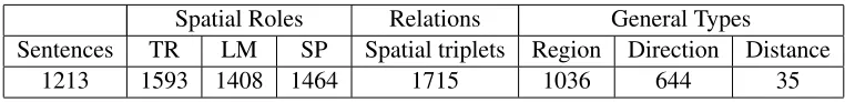
files that include 1213 sentences in total. This is an extension of the dataset used in (Kordjamshidi et al., 2011c). The original corpus was available free of charge and without copyright restrictions. The corpus contains images taken by tourists with de-scriptions in different languages. The texts describe objects, and their absolute and relative positions in the image. This makes the corpus a rich resource for spatial information. However the descriptions are not always limited to spatial information. Therefore they are less domain-specific and contain free expla-nations about the images. Table 1 shows the detailed statistics of this data. The average length of the sen-tences in this data is about 15 words including punc-tuation marks with a standard deviation of 8.
The spatial roles are assigned both to phrases and
their headwords, but only the headwordsare
eval-uated for this task. The spatial relations indicate a triplet of these roles. The general-type is assigned to each triplet of spatial indicator, trajector and land-mark.
At the starting point two annotators including one task-organizer and another non-expert annotator, an-notated 325 sentences for the spatial roles and rela-tions. The purpose was to realize the disagreement points and prepare a set of instructions in a way to achieve highest-possible agreement. From the first effort an inter-annotator agreement (Carletta, 1996) of 0.89 for Cohen’s kappa was obtained. We contin-ued with the a third annotator for the remaining 888 sentences. The annotator had an explanatory session and received a set of instructions and annotated ex-amples to decrease the ambiguity in the annotations.
To avoid complexity only the relations that are di-rectly expressed in the sentence are annotated and spatial reasoning was avoided during the annota-tions. Sometimes the trajectors and landmarks or both are implicit, meaning that there is no word in the sentence to represent them. For example in the
sentence Come over here, the trajector youis only
implicitly present. To be consistent with the number of arguments in spatial relations, in these cases we
use the termundefinedfor the implicit roles.
There-fore, the spatial relation in the above example is
<overSP undefinedT RhereLM>.
5.1 Data format
The data is released in XML format. The original textual files are split into sentences. Each sentence
is placed in a <SENTENCE/> tag and assigned an
identifier. This tag contains all the other tags which describe the content and spatial relations of one sen-tence.
The content of the sentence is placed in the
<CONTENT/> tag. The words in each sentence are assigned identifiers depending on their specific roles. Trajectors, landmarks and spatial indicators are identified by<TRAJECTOR/>,<LANDMARK/> and <SPATIAL INDICATOR/> tags, respectively. Each of these XML elements has an “ID” attribute that identifies a related word by its index. The “ID” prefixed by either “TW”, “LW” or “SW”, respec-tively for the mentioned roles. For example, a tra-jector with ID=“TW2” corresponds to the word at index 2 in the sentence. Indexes start at 0. Com-mas, parentheses and apostrophes are also counted as tokens.
Spatial relations are assigned identifiers too, and relate the role-playing words to each other.
Spa-tial relations are identified by the <RELATION/>
tag. The spatial indicator, trajector and
land-mark for the relation are identified by the “SP”, “TR” and “LM” attributes, respectively. The val-ues of these attributes correspond to the “ID” at-tributes in the <TRAJECTOR/>, <LANDMARK/>
and <SPATIAL INDICATOR/> elements. If a tra-jector or landmark is implicit, then the index of “TR” or “LM” attribute will be set to a dummy
index. This dummy index is equal to the
in-dex of the last word in the sentence plus one.
In this case, the value of TRAJECTOR or LAND
-MARK is set to “undefined”. The coarse-grained
spatial type of the relation is indicated by the “GENERAL TYPE” attribute and gets one value in {REGION, DIRECTION, DISTANCE}. In the original data set there are cases annotated with
multiple spatial types. This is due to the
Spatial Roles Relations General Types
Sentences TR LM SP Spatial triplets Region Direction Distance
[image:6.612.115.496.53.99.2]1213 1593 1408 1464 1715 1036 644 35
Table 1: Number of annotated components in the data set.
and relevant type for a relation, from the annotator’s point of view. This task considers labeling words rather than phrases for all spatial roles. However, in the XML file for spatial indicators often the whole phrase is tagged. In these cases, the index of the indicator refers to one word which is typically the spatial preposition of the phrase. For evaluation only the indexed words are compared and should be pre-dicted correctly.
Below is one example copied from the data. For more examples and details about the general anno-tation scheme see (Kordjamshidi et al., 2010b).
<SENTENCE ID=‘S11’> <CONTENT>
there are red umbrellas in a park on the right . </CONTENT>
<TRAJECTOR ID=‘TW3’> umbrellas
</TRAJECTOR>
<LANDMARK ID=‘LW6’> park
</LANDMARK>
<SPATIAL INDICATOR ID=‘SW4’> in
</SPATIAL INDICATOR>
<RELATION ID=‘R0’ SP=‘SW4’ TR=‘TW3’ LM=‘LW6’GENERAL TYPE=‘REGION’/> <SPATIAL INDICATOR ID=‘SW7’> on the right
</SPATIAL INDICATOR>
<RELATION ID=‘R1’ SP=‘SW7’ TR=‘TW3’ LM=‘LW6’GENERAL TYPE=‘DIRECTION’/> </SENTENCE>
The dataset, both train and test, also the 10-fold splits are made available in the LIIR research group
webpage of KU Leuven.1
6 Evaluation methodology
According to the usual setting of the shared tasks our evaluation setting was based on splitting the data set into a training and a testing set. Each set con-tained about 50% of the whole data. The test set
re-1
http://www.cs.kuleuven.be/groups/liir/software/ SpRL Data/
leased without the ground-truth labels. However, af-ter the systems submission deadline the ground-truth test was released. Hence the participant group per-formed an additional 10-fold cross validation eval-uation too. We report the results of both evaleval-uation settings.
Prediction of each component includingTRAJEC
-TORs, LANDMARKs and SPATIAL-INDICATORs is evaluated on the test set using their individual spatial element XML tags. The evaluation metrics of pre-cision, recall and F1-measure are used, which are defined as:
recall= T PT P+F N (1)
precision= T PT P+F P (2)
F1 = 2(recall∗recall+∗precisionprecision), (3)
where:
TP = the number of system-produced XML tags that match an annotated XML tag,
FP = the number of system-produced XML tags that do not match an annotated tag,
FN = the number of annotated XML tags that do not match a system-produced tag.
For the roles evaluation two XML tags match
when they have exactly same identifier. In fact,
when the identifiers are the same then the role and the word index are the same. In addition, systems are evaluated on how well they are able to retrieve triplets of (trajector, spatial-indicator, landmark), in terms of precision, recall and F1-measure. The TP,
FP, FN are counted in a similar way but twoRELA
-TIONtags match if the combination of theirTR,LM
andSPis exactly the same. In other words a true
pre-diction requires all the three elements are correctly predicted at the same time.
i.e {region, direction, distance} at the same time.
To evaluate theGENERAL-TYPEsimilarly theRELA
-TIONtag is checked. For a true prediction, an exact
match between the ground-truth and all the elements
of the predictedRELATIONtag includingTR,LM,SP
andGENERAL-TYPEis required.
7 Systems and results
One system with two runs was submitted from the University of Texas Dallas. The two runs (Roberts
and Harabagiu, 2012), UTDSPRL-SUPERVISED1
and UTDSPRL-SUPERVISED2 are based on the
joint classification of the spatial triplets in a bi-nary classification setting. To produce the candi-date (indicator, trajector, landmark) triples, in the first stage heuristic rules targeting a high recall are used. Then a binary support vector machine clas-sifier is employed to predict whether a triple is a spatial relation or not. Both runs start with a large number of manually engineered features, and use floating forward feature selection to select the most
important ones. The difference between the two
runs of UTDSPRL-SUPERVISED1 and UTDSP
RL-SUPERVISED2 is their feature set. Particularly, in UTDSPRL-SUPERVISED1 a joint feature based on
the conjunctions (e.g.and,but) is considered before
running feature selection but this feature is removed
in UTDSPRL-SUPERVISED2.
The submitted runs are compared to a previous system from the task organizers (Kordjamshidi et al., 2011c) which is evaluated on the current data
with the same settings. This system, KUL-SKIP
-CHAIN-CRF, uses a skip chain conditional random field (CRF) model (Sutton and MacCallum, 2006) to annotate the sentence as a sequence. It considers the long distance dependencies between the prepo-sitions and nouns in the sentence.
The type and structure of the features used in the UTD and KUL systems are different. In the UTD system, the classifier works on triples and the fea-tures are of two main types: (a) argument-specific features about the trajector, landmark, or indicator e.g., the landmark’s hypernyms, or the indicator’s first token; and (b) joint features that consider two or more of the arguments, e.g. the dependency path between indicator and landmark. For more detail, see (Roberts and Harabagiu, 2012). In the KUL
sys-Label Precsion Recall F1
TRAJECTOR 0.731 0.621 0.672
LANDMARK 0.871 0.645 0.741
SPATIAL-INDICATOR 0.928 0.712 0.806
RELATION 0.567 0.500 0.531
[image:7.612.313.546.54.138.2]GENERAL-TYPE 0.561 0.494 0.526
Table 2: UTDSPRL-SUPERVISED1: The University of Texas-Dallas system with a larger number of fea-tures,test/train one split.
Label Precsion Recall F1
TRAJECTOR 0.782 0.646 0.707
LANDMARK 0.894 0.680 0.772
SPATIAL-INDICATOR 0.940 0.732 0.823
RELATION 0.610 0.540 0.573
[image:7.612.312.546.199.283.2]GENERAL-TYPE 0.603 0.534 0.566
Table 3: UTDSPRL-SUPERVISED2: The University of Texas-Dallas system with a smaller number of features, test/train one split.
Label Precsion Recall F1
TRAJECTOR 0.697 0.603 0.646
LANDMARK 0.773 0.740 0.756
SPATIAL-INDICATOR 0.913 0.887 0.900
RELATION 0.487 0.512 0.500
Table 4: KUL-SKIP-CHAIN-CRF: The organizers’ sys-tem (Kordjamshidi et al., 2011c)- test/train one split.
tem, the classifier works on all tokens in a sentence, and a number of linguistically motivated local and pairwise features over candidate words and preposi-tions are used. To consider long distance dependen-cies a template, called a preposition template, is used in the general CRF framework. Loopy belief
prop-agation is used for inference. Mallet2and GRMM:3
implementations are employed there.
Tables 2, 3 and 4 show the results of the three runs in the standard setting of the shared task us-ing the train/test split. In this evaluation settus-ing the UTDSPRL-SUPERVISED2 run achieves the highest performance on the test set, with F1 of 0.573 for the full triplet identification task, and an F1 of 0.566 for additionally classifying the triplet’s general-type
2
http://mallet.cs.umass.edu/download.php
System Precsion Recall F1
KUL-SKIP-CHAIN-CRF 0.745 0.773 0.758
[image:8.612.171.445.53.97.2]UTDSPRL-SUPERVISED2 0.773 0.679 0.723
Table 5: The RELATION extraction of KUL-SKIP-CHAIN-CRF (Kordjamshidi et al., 2011c) vs. UTDSP RL-SUPERVISED2 evaluated with 10-fold cross validation
correctly. It also consistently outperforms both the UTDSPRL-SUPERVISED1 run and the KUL-SKIP -CHAIN-CRFsystem on each of the individual trajec-tor, landmark and spatial-indicator extraction.
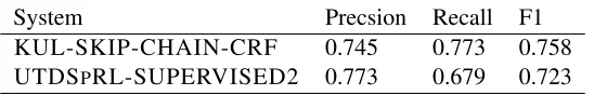
The dataset was relatively small, so we released the test data and the two systems were addition-ally evaluated using 10-fold cross validation. The results of this cross-validation are shown in
Ta-ble 5. The UTDSPRL-SUPERVISED2 run achieves
a higher precision, while the KUL-SKIP-CHAIN
-CRF system achieves a higher recall. It should be
mentioned the 10-fold splits used by KUL and UTD are not the same. This implies that the results with exactly the same cross-folds may vary slightly from these reported in Table 5.
Using 10-fold cross validation, we also evaluated the classification of the general-type of a relation given the manually annotated positive triplets. The UTDSPRL-SUPERVISED2 system achieved F1= 0.974, and similar experiments using SMO-SVM in (Kordjamshidi et al., 2011b; Kordjamshidi et al., 2011a) achieved F1= 0.973. Thus it appears that identifying the general-type of a relation is a rela-tively easy task on this data.
Discussion. Since the feature sets of the two sys-tems are different and given the evaluation results in the two evaluation settings, it is difficult to assert which model is better in general. Obviously using joint features potentially inputs richer information to the model. However, it can increase the sparsity in one hand and overfitting on the training data on the other hand. Another problem is that finding heuris-tics for high recall that are sufficiently general to be used in every domain is not an easy task. By increas-ing the number of candidates the dataset imbalance will increase dramatically. This can cause a lower performance of a joint model based on a binary clas-sification setting when applied on different data sets. It seems that this task might require a more elabo-rated structured output prediction model which can
consider the joint features and alleviate the problem of huge negatives in that framework while consider-ing the correlations between the output components.
8 Conclusion
The SemEval-2012 spatial role labeling task is a starting point to formally consider the extraction of spatial semantics from the language. The aim is to consider this task as a standalone linguistic task which is important for many applications. Our first practice on this task and the current submitted sys-tem to SemEval 2012 clarify the type of the features and the machine learning approaches appropriate for it. The proposed features and models help to per-form this task automatically in a reasonable accu-racy. Although the spatial scheme is domain inde-pendent, the achieved accuracy is dependent on the domain of the used data for training a model. Our future plan is to extend the data for the next work-shops and to cover more semantic aspects of spatial information particularly for mapping to formal spa-tial representation models and spaspa-tial calculus.
Acknowledgments
Special thanks to Martijn Van Otterlo for his great cooperation from the initiation phase and in the
growth of this task. Many thanks to Sabine
Drebusch for her kind and open cooperation in an-notating the very first dataset. Thanks to Tigist Kas-sahun for her help in annotating the current dataset. Thanks the participant team of the University of Texas Dallas and their useful feedback on the an-notated data.
References
T. Butko, C. Nadeu, and A. Moreno. 2011. A multi-lingual corpus for rich audio-visual scenedescription in a meeting-room environment. In ICMI workshop on multimodal corpora for machine learning: Taking Stock and Roadmapping the Future.
J. Carletta. 1996. Assessing agreement on classification tasks: the kappa statistic. Computational Linguistics, 22(2):249–254.
A. G. Cohn and J. Renz. 2008. Qualitative spatial repre-sentation and reasoning. In Handbook of Knowledge Representation, volume 3 ofFoundations of Artificial Intelligence, pages 551 – 596. Elsevier.
A. Galton. 2009. Spatial and temporal knowledge rep-resentation. Journal of Earth Science Informatics, 2(3):169–187.
M. Grubinger, P. Clough, Henning M¨uller, and Thomas Deselaers. 2006. The IAPR benchmark: A new evalu-ation resource for visual informevalu-ation systems. In In-ternational Conference on Language Resources and Evaluation (LREC).
J. Hois and O. Kutz. 2008. Natural language meets spa-tial calculi. In Christian Freksa, Nora S. Newcombe, Peter G¨ardenfors, and Stefan W¨olfl, editors, Spatial Cognition, volume 5248 ofLecture Notes in Computer Science, pages 266–282. Springer.
J. Hois, R. J. Ross, J. D. Kelleher, and J. A. Bateman. 2011. Computational models of spatial language in-terpretation and generation. InCOSLI-2011.
P. Kordjamshidi, M. van Otterlo, and M. F. Moens. 2010a. From language towards formal spatial calculi. InWorkshop on Computational Models of Spatial Lan-guage Interpretation (CoSLI 2010, at Spatial Cogni-tion 2010).
P. Kordjamshidi, M. van Otterlo, and M. F. Moens. 2010b. Spatial role labeling: Task definition and anno-tation scheme. InProceedings of the Seventh confer-ence on International Language Resources and Eval-uation (LREC’10).
P. Kordjamshidi, J. Hois, M. van Otterlo, and M.-F. Moens. 2011a. Machine learning for interpretation of spatial natural language in terms of qsr. Poster Presen-tation at the 10th International Conference on Spatial Information Theory (COSIT’11).
P. Kordjamshidi, J. Hois, M. van Otterlo, and M.F. Moens. 2011b. Learning to interpret spatial natural language in terms of qualitative spatial relations. Rep-resenting space in cognition: Interrelations of behav-ior, language, and formal models. Series Explorations in Language and Space, Oxford University Press, sub-mitted.
P. Kordjamshidi, M. Van Otterlo, and M.F. Moens. 2011c. Spatial role labeling: Towards extraction of spatial relations from natural language. ACM Trans. Speech Lang. Process., 8:1–36, December.
I. Mani, J. Hitzeman, J. Richer, D. Harris, R. Quimby, and B. Wellner. 2008. SpatialML: Annotation scheme, corpora, and tools. In Nicoletta Calzolari, Khalid Choukri, Bente Maegaard, Joseph Mariani, Jan Odjik, Stelios Piperidis, and Daniel Tapias, editors, Proceed-ings of the Sixth International Language Resources and Evaluation (LREC’08). European Language Re-sources Association (ELRA).
MITRE Corporation. 2010. SpatialML: Annotation scheme for marking spatial expression in natural lan-guage. Technical Report Version 3.0.1, The MITRE Corporation.
J. Pustejovsky and J.L. Moszkowicz. 2009. Integrat-ing motion predicate classes with spatial and tempo-ral annotations. InCoLing 2008: Companion volume Posters and Demonstrations, pages 95–98.
J. Pustejovsky, J. Moszkowicz, and M. Verhagen. 2011. Iso-space: The annotation of spatial information in language. InProceedings of ISA-6: ACL-ISO Inter-national Workshop on Semantic Annotation.
K. Roberts and S.M. Harabagiu. 2012. Utd-sprl: A joint approach to spatial role labeling. InSubmitted to this workshop of SemEval-2012.
R. Ross, J. Hois, and J. Kelleher. 2010. Computational models of spatial language interpretation. In COSLI-2010.
O. Stock, editor. 1997.Spatial and Temporal Reasoning. Kluwer.
C. Sutton and A. MacCallum. 2006. Introduction to con-ditional random fields for relational learning. In Lise Getoor and Ben Taskar, editors,Introduction to Statis-tical Relational Learning. MIT Press.
D. A. Tappan. 2004. Knowledge-Based Spatial Rea-soning for Automated Scene Generation from Text De-scriptions. Ph.D. thesis.
S. Tellex, T. Kollar, S. Dickerson, M. R. Walter, and N. Roy A. G. Banerjee, S. Teller. 2011. Understand-ing natural language commands for robotic naviga-tion and mobile manipulanaviga-tion. InProceedings of the National Conference on Artificial Intelligence (AAAI), San Francisco, CA.