Location Based System Using GPS-Fishermen
SMS Alert System
1
M.Vivekanadan,
2Dr. S.Kanaga Suba Raja,
3V.Balaji
1Assistant Professor, Dept. of IT, Easwari Engineering College, Chennai, Tamil Nadu, India 2Associate Professor, Dept. of IT, Easwari Engineering College, Chennai, Tamil Nadu, India 3Assistant Professor, Dept. of IT, Easwari Engineering College, Chennai, Tamil Nadu, India
ABSTRACT: The Location Based system Using GPS system is to identify the weather condition in sea side before going into sea. By using GPS we can view the weather condition and If u across border automatically, sends SMS in your friend contact list. We Proposed system a fisher friend mobile runs on android operating System. It is fast communicate with server and reliable and provides real time safely. This application based on GPS Location based to trace the current location point. It is to secure the fishermen by using this android mobile application. If tsunami, came automatically get SMS Alert message in your mobile phone. In Emergency situation you can very quickly send the SMS to your contact friend list.
I. INTRODUCTION
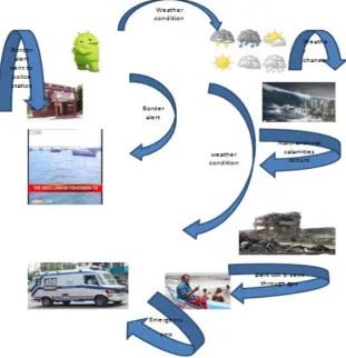
The system is used to detect the maritime boundary of the country where the long time dispute between Sri Lanka and India still exists. This mainly happens when fisherman crosses maritime border of neighboring country as he is not aware of the limits in sea. The proposed system uses a GPS receiver which receives signals from the satellite and gives the current position of the boat. With already known details of the latitude and longitude of the maritime boundary, the microcontroller calculates the current position and stored boundary positions and indicates the fisherman that he has crossed the boundary by an alarm system. It also uses a message transmitter to send message to the base station which monitors the boats in the sea. This system provides an indication to both fisherman and to coastal guard. Thus the system saves the lives of the fisherman or reduces the damages caused to them by Lankan coast guards. Additionally, sensors for iceberg detection and tsunami prediction have been included. A report for weather can also be obtained through temperature and humidity sensor
II. LITERATURE SURVEY
the satellite and gives the current position of the boat. With already known details of the latitude and longitude of the maritime boundary, the microcontroller calculates the current position and stored boundary positions and indicates the fisherman that he has crossed the boundary by an alarm system. It also uses a message transmitter to send message to the base station which monitors the boats in the sea. This system provides an indication to both fisherman and to coastal guard. Thus the system saves the lives of the fisherman or reduces the damages caused to them by Lankan coast guards. Additionally, sensors for iceberg detection and tsunami prediction have been included. A report for weather can also be obtained through temperature and humidity sensor[3]. The system is mainly for fishermen are used to detect the maritime boundary between the two countries. This mainly happens when fisherman crosses maritime border of neighboring country as he is not aware of the limits in sea. The proposed system uses a GPS concept to receive signals from the satellite and gives the current position of the boat. The latitude and longitude of the maritime boundary. To calculates the current position, stored boundary positions and indicates the fisherman that he has crossed the boundary by an alarm, vibrate& notification. The alert will be send to the server section and the fisherman will get the alert visually. This will be more user friendly for the fisherman near the border areas[4]..
III. SYSTEM ARCHITECTURE
System architecture is the conceptual model that defines the structure and/or behavior of the system. It provides a way in which products can be procured, systems can be developed an architectural overview of the overall system.
1.GPSLOCATION BASED ALERT SMS
Even if the GPS on the device is enabled, the application is able to locate the ... you to track Android devices and send free text messages between the users. If u across border automatically, send sms in your friend contact list.
This project is to “Securing the Fishermen in Maritime Border by Using Android Application”. It is to secure the fishermen by using this Android mobile application.
2.EMERGENCY SITUATION YOU CAN QUICKLY SEND THE SMS TO YOUR CONTACT FRIEND LIST.
You need to register your mobile phone before using the emergencySMS service. This is best done before you need help. You can register by sending an SMS. In Emergency situation automatically you can very quickly send the SMS to your contact friend list.
3.SMSTSUNAMI WARNING
If tsunami came automatically get SMS Alert message in your mobile phone. SMS-Tsunami-Warning.com is a web-based Earthquake Alert System sourced from international seismic scientific centers that serves also as Tsunami Warning
System. In IOC is coordinating the implementation of the global tsunami warning system.
Our website monitors global earthquake activity in real time and delivers vital information (earthquake location, magnitude, depth, threat level, proximity to cities, etc.) to endangered people when they need it most. Although it's NOT possible to predict the time and the location of an Earthquake, it's crucial to handle this information in the quickest time possible, especially when powerful earthquakes strike in the ocean. Our website instantly alerts registered members by sending them a SMS text message to their mobile phones
4.WEATHER CONDITION
We get this application easily find today morning temperature condition. Weather is the state of the atmosphere, to the degree that it is hot or cold, wet or dry, calm or stormy Get the Current weather conditions, temperature, pressure, humidity index, dew point, UV Index, alerts, today's forecasts and Hourly forecasts for Chennai
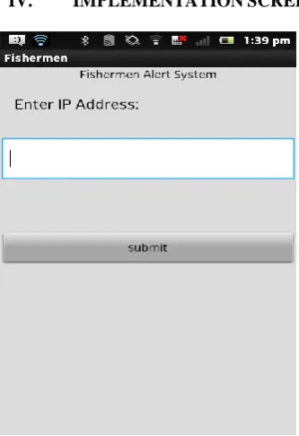
IV. IMPLEMENTATIONSCREEN
(a) (b)
(b(
(c) (d)
(e) Alert Screen for each Area and Alert message
V.CONCLUSIONANDFUTUREWORK
This system implements GPS is to create a security system. The fisherman, while navigating crosses the maritime boundary, unknowingly as they are unable to visualize it in the ocean which causes loss to its life. Through this project a GPS based security system is provided to the fisherman so that they can find out when they are in danger. This application easily find today morning temperature condition. Weather is the state of the atmosphere, to the degree that it is hot or cold, wet or dry, calm or stormy.
the size of the kit by using GPS+GSM on the same module of GPS navigator.We can increase the accuracy up to 3m by increasing the cost of the GPS receivers.
REFERENCES
1. R.Karthikeyan,A.Dhandapani,U.Mahalingham”Protecting ofFishermen on Indian Maritime Boundaries”,Journal of Computer Applications ISSN: 0974 – 1925, Volume-5, Issue EICA2012-3, and February 10, 2012.
2. S. Mani Sunder “Deep sea fishermen patrol system for coastal intruder positioning”/International Journal of scientific engineering and technology (ISSN : 2277-1581)Volume 2 Issue 3, PP : 129-132 1 april 2013
3. “Navigation Alert System for Fisherman Using Lab-View” International Journal of Engineering and Technical Research (IJETR) ISSN: 2321-0869, Volume-3, Issue-4, April 2015
4. “Multi Purpose Marine Wireless Networks For Fisherman Aid And Other Applications” International Journal of Engineering Research & Technology (IJERT) ISSN: 2278-0181 IJERTV2IS70016 Vol. 2 Issue 7, July – 2013
5. “DESIGN OF BORDER ALERT SYSTEM FOR FISHERMEN USING GPS” International Journal of Students Research in Technology & Management Vol 2 (02), March-April 2014, ISSN 2321-2543