Regional-scale multiple reference stations for carrier phase-based GPS
positioning: A correction generation algorithm
Chris Rizos, Shaowei Han, and Horng-Yue Chen
School of Geomatic Engineering, The University of New South Wales, Sydney, NSW 2052, Australia
(Received January 6, 2000; Revised August 7, 2000; Accepted August 7, 2000)
Continuously operating GPS networks have been used for many years in support of: (a) geodetic goals such as the determination of crustal motion on a variety of spatial scales, and (b) to provide pseudo-range corrections for Wide Area DGPS (WADGPS) implementations. Recently, regional-scale GPS permanent networks have been developed for multi-functional uses, including to support centimetre-accuracy, medium-range, carrier phase-based GPS positioning for surveying or precise navigation applications. In such an implementation the generation of carrier phase correction messages in a manner analogous to WADGPS requires that the integer ambiguities between GPS reference stations be fixed in real-time. Although the ambiguities could be resolved at the beginning of operation the challenge remains: how to recover an integer ambiguity if a cycle slip or data gap occurs, or if a new satellite rises? In this paper, the linear data combination algorithm that has been used is described, and the issue of “ambiguity recovery” techniques for data correction generation purposes is addressed. Three strategies are suggested: (1) using an “ambiguity recovery” technique if the data gap is shorter than a minute or so; (2) re-determining the integer ambiguities using an ionospheric correction derived from the tracking to other satellites when a new satellite rises, or after a long period of data loss, and; (3) re-determining the integer ambiguities with the aid of data corrections generated on previous days. Several 7-day continuous data sets were used for algorithm testing. The corrections can be generated from multiple reference stations in the post-processing mode and then used for comparison purposes with the simulated real-time processing mode using the proposed algorithm. Results confirm that the proposed algorithm can provide reliable carrier phase data corrections for centimetre-accuracy, real-time GPS positioning.
1.
Introduction
Permanent GPS reference stations are being increasingly established all over the world. Regional-scale GPS perma-nent networks are now being deployed to support a multitude of applications:
• high precision, real-time GPS kinematic positioning over medium-range baselines,
• rapid static positioning system using low-cost GPS re-ceivers,
• machine control applications, e.g. precise farming, and • deformation monitoring, e.g. volcano and structural
monitoring.
In order to operate a regional-scale GPS network a num-ber of the challenges must be addressed. One of them is how to generate carrier phase ‘corrections’ which could re-duce distance-dependent errors such as orbit bias, ionosphere and troposphere delays, as well as station-dependent errors, e.g. multipath, measurement noise, etc.? Another is how to compute ‘correction terms’ in real-time, e.g. implement-ing real-time ambiguity resolution for reference stations over regional-scale areas? How to format and deliver the
‘correc-Copy right cThe Society of Geomagnetism and Earth, Planetary and Space Sciences (SGEPSS); The Seismological Society of Japan; The Volcanological Society of Japan; The Geodetic Society of Japan; The Japanese Society for Planetary Sciences.
tions’ for different user applications? And so on.
A linear combination model for such network-based posi-tioning has been proposed by Han (1997) and Han and Rizos (1997), which can account for orbit bias and ionospheric de-lay, as well as mitigate tropospheric dede-lay, multipath and measurement noise across networks many tens of kilome-tres across. The procedure requires that the data from the GPS reference station network be used to derive corrections to the double-differenced carrier phase data formed between any user receiver (located within the area bounded by the network) and a single reference receiver. Both static and kinematic positioning modes can be thus supported.
Li and Gao (1998), Odijk (1999) and Schaeret al.(1999) have studied the impact of atmospheric delay errors across regional-scale GPS networks, and have attempted to resolve the ambiguities in time. However, network-based, real-time, carrier phase-based GPS positioning requires that the carrier phase ‘corrections’ generated from the reference sta-tion network data must be broadcast to users. To ensure ser-vice availability, all the integer ambiguities associated with the network processing must be fixed ‘instantaneously’. In this paper, a correction generation algorithm suitable for the regional-scale GPS networks is proposed. The characteris-tics of the double-differenced ionospheric delay and tropo-spheric delay are discussed. Finally, the results for medium-range, single-frequency positioning will be presented to demonstrate the utility of network-based positioning.
796 C. RIZOSet al.: GPS POSITIONING USING MULTIPLE REFERENCE STATIONS
2.
Linear Combination Model
The single-differenced observations from a user receiver to multiple reference receivers are formed as:
φi =ρi+dρi−c·d Ti+λ·Ni
−dion,i+dtrop,i+dmpφ ,i+φi (1)
where(·)= (·)u−(·)i;i indicates the reference station,
anduthe user station. Based on the conditions given in Han and Rizos (1996), a set of parameters can be computed:
3
whereXuandXiare the coordinates of the user receiver and
reference receiver in the Gaussian plane coordinate system. The linear combination of the single-differenced observa-tions can be written as:
3
2.1 Features of linear combination technique
The linear combination technique proposed by Han and Rizos (1997) has several attractive features. First of all the orbit bias is taken into account, while the ionospheric delay is removed using an epoch-by-epoch and satellite-by-satellite ionosphere model. The tropospheric delay is reduced by in-terpolation based on the North and East coordinates of the reference and user receivers after applying an apriori tro-posphere model correction. The multipath at the reference receivers is mitigated by weighted averaging. The observa-tion noise is mitigated by weighted averaging.
2.2 Correction term generation
Figure 1 illustrates the geometric relationship between the GPS reference stations and the user stations.
Define the residual vectors:
V1,3= ∇φ1,3− ∇N1,3− ∇ρ1,3
V2,3= ∇φ2,3− ∇N2,3− ∇ρ2,3 (6)
The double-differenced observation model can be written as:
∇φu,3− α1·V1,3+α2·V2,3 =∇ρu,3+λ· ∇Nu,3+"3
i=1αi·∇φi
(7)
Where the subscripts 1, 2, 3 represent the reference stations, andudenotes the user stations.
Using the known coordinates and known integer ambi-guities, the correction vectorsV1,3,V2,3 can be computed.
Fig. 1. The triangles denote the GPS reference stations, and the dots denote the user stations.
Therefore, for real-time applications, the correction vectors, together with the carrier phase and pseudo-range data from reference station 3, must be sent to any user receiver.
3.
Real-Time Ambiguity Resolution
For medium-range, real-time, high accuracy applications, the ambiguities associated with the reference stations need to befixed (i.e. resolved)all of the time. Then the correction term can be generated. When the reference system is set up, the integer ambiguities can be initialised. If a cycle slip or data gap of the order of a few minutes occurs, an“ambiguity recovery”technique can be used (Han, 1997). If after a long data gap, or when a new satellite rises, the relevant ambiguity will have to be estimated and resolved. This is quite a chal-lenge due to the presence of residual (double-differenced) ionospheric and tropospheric delay over medium length base-lines (defined here as being from several tens of kilometres to about 100 km).
3.1 Ionospheric delay
The ionospheric delay exhibits some similarity between successive days. In addition, the ionospheric delay informa-tion derived from other tracked satellites can also help esti-mate the ionospheric delay for a newly risen satellite. Both of these types of ionospheric delay information can be used to generate a‘synthetic’ionospheric delay to assist ambiguity resolution for the reference station network processing.
The double-differenced ionospheric delay can be com-puted as:
L1,L2are the carrier phase observations
f1, f2are the associated frequencies
N1,N2are the integer ambiguities forL1,L2
λ1,λ2are the wavelengths.
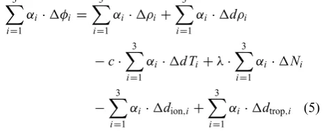
Fig. 2. Double-differenced ionospheric delay in Kyushu, Japan, 1997.
Fig. 3. Ionosphere delay similarity and cross-correlation value for 5 successive days (90 km baseline).
As an example, Fig. 2 displays the double-differenced iono-spheric delay on satellite number 24 and 04 for two successive days.
The cross-correlation value in the case of a low elevation satellite (newly risen satellite SV 19) from an analysis of the double-differenced ionospheric delay for 5 successive days at the stations 0479–0475 (90 km baseline) is shown in Fig. 3. The y-axis is the cross-correlation value and the x-axis is the epoch number. There are 20 epochs of the newly
arisen satellite considered in this cross-correlation test. The normalised cross-correlation value is 0.78.
3.2 Tropospheric delay
798 C. RIZOSet al.: GPS POSITIONING USING MULTIPLE REFERENCE STATIONS
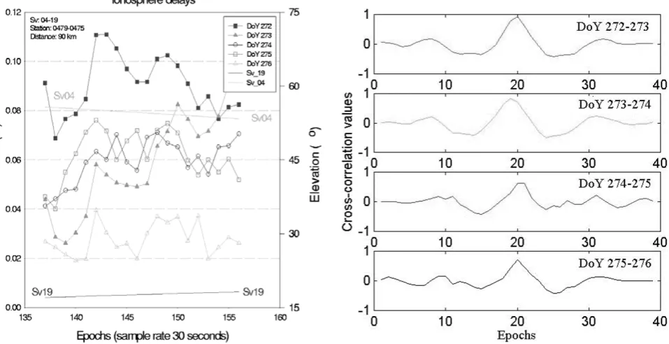
Fig. 4. Double-differenced tropospheric delays in Kyushu, Japan, 1997.
assumed to have been significantly mitigated. Therefore, the ionospherie-free linear combination can be derived to esti-mate the tropospheric delay. It means that the correction for tropospheric delay is not physically motivated but esti-mated from the correction of ionospheric delay. In Eq. (9), the tropospheric delay,∇Trop, inL1andL2are assumed
the same. However, estimations of Eqs. (8) and (9) are not completely independent:
The tropospheric delay for a newly risen satellite could then be estimated using both information sources. Figure 4 displays the double-differenced tropospheric delay for satel-lite number 10 and 04 on successive days, using Eq. (9).
Figure 5 shows the tropospheric delay similarity and cross-correlation values of the double-differenced tropospheric de-lay between successive days (for a 90 km baseline). The normalised cross-correction values are at the 0.9 level.
Using the characteristic that the double-differenced iono-spheric and tropoiono-spheric biases have a high correlation be-tween successive days (as illustrated in Figs. 3 and 5), when a new satellite rises a linear polynomial function model (based on data from successive days and previous epochs) can be determined, and a double-differenced ionospheric and tropo-spheric delay value for the new satellite can be estimated.
4.
Experimental Results
The experiment had two main objectives. Thefirst was to study the ability of the polynomial function model
(us-ing data from successive days and previous epochs) to es-timate the atmospheric delay when a new satellite rises or after a long data gap occurs. The second objective was to test the performance of the linear combination observation model for medium-range GPS rapid static positioning assum-ing the user receiver is a sassum-ingle-frequency instrument. Fig-ure 6 displays one part of the Geographic Survey Institute’s (GSI) permanent GPS network in Kyushu, Japan. All perma-nent stations host dual-frequency GPS receivers, therefore all station coordinates are computed using the ionosphere-free combination. These results are considered as ground truth for experimental comparisons.
4.1 Ambiguity resolution for newly risen satellites—the reference station
40 satellite rises (cutoff angle was 15◦) were observed at stations 0479 and 0475 (90 km baseline) on DoY 272, 1997. The characteristic that the double-differenced ionospheric and tropospheric delays are similar between successive days and on previous epochs has been used in the data processing strategy described earlier to aid ambiguity resolution. The result of this test is illustrated in Fig. 7. Thex-axis is the newly risen satellite numbers and the y-axis is the epoch numbers for correct ambiguity resolution (sample rate was 30 sec). Applying the proposed polynomial model for am-biguity resolution, the estimation time can be lessened and the success rate can be improved, as indicated by the dark colour.
4.2 Positioning results—the user stations
cor-Fig. 5. Tropospheric delay similarity and cross-correlation value for 6 successive days (90 km baseline).
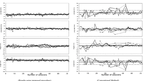
Fig. 6. Some stations in GSI’s Kyushu GEONET network, Japan.
rections, or without the incorporation of correction terms, for 40 minute observation sessions. The higher accuracy results are obtained when the correction terms are applied in the baseline processing. The left hand graph shows the result with correction terms. It can be seen that the mean offsets
Fig. 7. Number of epochs needed for ambiguity resolution for newly risen satellite (cutoff angle was 15◦).
800 C. RIZOSet al.: GPS POSITIONING USING MULTIPLE REFERENCE STATIONS
(Results using proposed procedure) (Conventional Method)
Fig. 8. White triangles (23 km baseline, mean: short dash line); solid circles (32 km, mean: solid line); white squares (55 km, mean: dotted line); solid squares (77 km, mean: long dash line).
Table 1. The mean offsets (in mm) and standard deviation (in mm) for each session’s (40 min) results over two days, for the four baseline in the Kyushu GSI network, using the multiple reference station methodology.
Table 2. The mean offsets (in mm) and standard deviation (in mm) of variations for each session’s (40 min) results without corrections from the multiple reference station methodology.
5.
Concluding Remarks
A linear combination functional model for network-based GPS positioning has been proposed in which the orbit bi-ases and the ionospheric delay terms are eliminated and, in addition, the tropospheric delay, multipath and observation noises can be reduced. A real-time ambiguity resolution technique for newly risen satellites is proposed here, in which
the ionospheric and tropospheric delays are estimated using information from currently tracked satellites and previous days’tracking. The carrier phase corrections can then be determined using multiple GPS reference stations and the broadcast ephemeris. The results show that the generated corrections do significantly improve the positioning results.
Acknowledgments. The third author is supported by a study grant from Taiwan’s Institute of Earth Sciences, Academia Sinica, to un-dertake research towards a Ph.D. at The University of New South Wales.
References
Han, S., Carrier phase-based long-range GPS kinematic positioning, PhD Dissertation, UNISURV S-49, School of Geomatic Engineering, The University of New South Wales, 185 pp, Sydney, Australia, 1997. Han, S. and C. Rizos, GPS network design and error mitigation for real-time
continuous array monitoring systems, Proc. 9th Int. Tech. Meeting of the Satellite Division of the U.S. Inst. of Navigation GPS ION’96, Kansas City, Missouri, 17–20 September, 1827–1836, 1996.
Han, S. and C. Rizos, An instantaneous ambiguity resolution technique for medium-range GPS kinematic positioning, Proc. 10th Int. Tech. Meeting of the Satellite Division of the U.S. Inst. of Navigation GPS ION’97, Kansas City, Missouri, 16–19 September, 1789–1800, 1997.
Li, Z. and Y, Gao, Improving ambiguity resolution for a regional area DGPS system using multiple days of data, Proc. 11th Int. Tech. Meeting of the Satellite Division of the U.S. Inst. of Navigation GPS ION’98, Nashville, Tennessee, 15–18 September, 399–406, 1998.
Odijk, D., Stochastic modelling of the ionosphere for fast GPS ambiguity resolution, Abstracts of IUGG’99, Birmingham, U.K., 19–24 July, 406, 1999.
Schaer, S., G. Beutler, and M. Rothacher, The impact of the atmosphere and other systematic errors on permanent GPS networks, Abstracts of IUGG’99, Birmingham, U.K., 19–24 July, 406, 1999.