Indicators for Analyzing Village Territories in the Baltic Sea Coast Areas
Dr.sc.ing. Kalinka M1; Dr.oec. Geipele S2; Dr.oec. Lazdins A3; Mg. sc. ing. Krutova U4; Mg. sc. ing. Holms J5
1Riga Technical University, [email protected] 2Riga Technical University, [email protected] 3Riga Technical University, [email protected] 4Riga Technical University, [email protected] 5Riga Technical University, [email protected]
Correspondence: [email protected]; Tel.: +371 29 449 881
Abstract. Spatial planning processes generally consider three levels of planning, which are applied to three types of territory: state, county and city. As the coastal areas are of a significant natural, cultural, economic and social value, as well as are characterized by a diverse range of involved society with specific interests and needs, there is a necessity for an innovative and new approach to sustainable development planning in accordance with the modern age of growth, as well as to work with local communities in specific areas. Planning of a small populated area like village territory is more diverse and subject to the wishes and needs of the population. Small territory planning involves a very narrow circle of individuals or communities that identify spatial development needs for the future, including socio-economic, cultural, and environmental and climate change scenarios. In order to assess the development opportunities and needs of the area, it is necessary to monitor the area by regularly updating data. As it is well known, methodically derived data (facts) provide objectivity and transparency. Nowadays, when information about the present and the past is circulating very fast, it is possible to analyze the current situation, to forecast the future using databases, and to show several constructed realities (scenarios) using the geographic information system (GIS). Therefore, it is crucial to explore and find out the local needs-based planning approach to the development of village in coastal areas.
Keywords: spatial village planning, coastal areas, local community, indicators of village planning, GIS application, GIS layers, territorial development
1. Introduction
Village as a term is very widespread in the description of the settlement. A small area may not always be considered a village and may also be considered suburban areas. As cities evolve, suburban areas are formed, which are divided into individual villages but at the same time are in the local area. The other way is that the villages are dispersed, i.e., at a great distance from each other or linearly behind each other, for example, coastal villages. Villages as a populated area are of a very dynamic size – they can be transformed as a city or may not exist as the population increases or decreases [26]. The status of village shall be granted and revoked by the municipality council, based on the local government territorial planning, in which the village border is defined and the need for developing a village is justified [26; 12].
The coast area around the Baltic Sea has tradition for fishing and culture, like the Viking culture and different small ethnographical groups like the suite, Kurland lives, Gauja lives in the Baltic region. An integrated approach is needed here because it provides a strategic, integrating and forward-looking framework to help achieve both sustainable development and nature conservation [28].
Village life for local territories depends on communication among local people. The best way is to be community. Typically, a community is a group of the people who have similar interests and live in the same place. Village community is a group of people with different interests, whose views do not depend on people around. People who live in villages must find the way for developing village active life. Social, cultural and economic interest groups are one of the intersections for active community in village.
The village life of the coastal area depends on migration of the people, tourism, job opportunities and climate change. Climate change is one of the factors that will have an effect in future. Sea resources bring an advantage to villages that are close to coastal areas.
The village territories in the coastal areas are of significant natural, cultural, economic and social value. They are characterized by a diverse range of stakeholders with specific interests and needs, such as communities, local people, municipalities, representatives of local business.
The aim of the research is to explore the village territory planning in the Baltic Sea Region in the context of using the geographic information system (GIS) and to highlight its topicality for the development of local needs-based planning approach in coastal areas.
The present research prioritizes the citizens’ interests in the village planning of coastal areas. An in-depth investigation of local needs-based planning approach and its justification will be provided in the further research on an indicator analyzing tool for new, informed and objective decision making and vivid solution in the village territory planning.
To approach the aim, the authors developed the indicator groups influencing village planning and showed the main idea of using hard data and GIS by designing the information system architecture of the indicator analyzing tool.
The research highlights how to collect and analyze data for small territories – village in the line with the territory development from socio-economic and planning point of view, as well as demonstrates the use of GIS. The GIS tools are used to collect, analyze, visualize the geospatial and analytical data, as well as support a transparent and inclusive planning process in the local territory.
The literature review, observation data collection, discourse analysis, induction, deduction and logical access methods have been used in the study. For the identification of indicators influencing the village planning, the expert interview method has been used.
2. Theoretical Framework
Rural development policy has been based on different theoretical models. A neo-endogenous model is currently in use, which envisages a greater role and involvement of local communities in planning, development processes, while respecting regional needs and general conditions [1; 10]. The problems of rural communities in the context of rural development have been directly or indirectly addressed in many studies, characterizing the general situation in rural areas of Latvia and analyzing public participation in decision-making [4; 16; 17]. Europe is experiencing a paradigm shift from the countryside as a place solely linked to agricultural production to a place that offers other services, experiences and goods not only for the rural population but also for citizens and tourists [5]. Increasingly, researchers are emphasizing the use of people-centered as well as area-based approaches to rural and regional development, respecting local specificity and conditions [2].
Various indicators have long been used in planning, but this does not preclude the development and diversification of the methodology for calculating indicators. The indicator should reflect the phenomenon in the process by tracking its evolution over a sufficiently long period, which also allows the trend to be assessed [9; 13]. There are numerous definitions of indicator. Broadly speaking, an
indicator can be a sign, symptom, signal, tip, clue, grade, rank, object, organism, or warning of some sort – many things in everyday life [19; 20; 21]. In other words, an indicator is simply “an operational representation of an attribute (quality, characteristic, property) of a system” [11]. Often, four basic dimensions are defined: social, environmental, economic and institutional. It should be considered that the indicator can carry a certain social burden, promoting public participation in the decision-making process [3].
To ensure sustainable development, simplified Banfields’s [29] rational model can be used in an infinite loop. Loop steps: 1) data collection, 2) analysis, 3) forecasting the future (planning), establishing goals (planning), design of alternatives (planning), 4) assessment, indicator screening, comparing with goals, 5) reaction to the land development trends. If necessary, using alternative development plans as input for Step 1 is necessary [30]. Reaction to the land development trends can
be implemented through ‘Stakeholders Dialog’ [31].
tool to describe the multidimensionality and complexity of social phenomena replacing the classical crisp approach, which generally tends to overestimate or underestimate social dynamics. Indicators are used to assess the potential of a site. A study by ESPON [7] has found that three key issues for territorial development are the following: 1) the need to better understand patterns of differentiation between different kinds of rural areas; 2) the nature of different opportunities for development which each of them faces; 3) the way in which such opportunities depend upon and may be strengthened by interaction between rural and urban areas. For the assessment of the Baltic Sea coastal area, indicator groups developed by researchers of the University of Latvia are used. The sustainable coastal development governance indicator system has been developed for Saulkrasti municipality and accepted by Saulkrasti local authority as part of supervision for municipal long-term strategy and mid-term program. The system contains 65 indicators, including: 19 environmental indicators divided into 7 thematic groups; 20 economic indicators divided into 6 thematic groups; 15 social indicators divided into 5 thematic groups; 8 governance indicators divided into 3 thematic groups; and 3 integral indicators. Most of the indicators are integrated into at least 2 dimensions of sustainability [8; 14]. In order to understand trends, continuous data collection and calculation of indicators should be carried out. A systemic monitoring must cover multiple scales of analysis, be able to link changes in the
economy to impacts on the environment and provide sufficient detail to answer policy relevant questions regarding specific aspects of the bioeconomy in an overarching framework. This has two
implications: 1) modelling is a key aspect of a systemic bioeconomy monitoring framework accompanied by further approaches such as economy-wide resource accounting and life-cycle analysis; 2) sustainability indicators and targets are essential to evaluate whether the bioeconomy transition contributes to sustainable development [22; 23].
In the authors’ research, systematization of information is one of the prerequisites, since the choice of key performance indicators depends, to a large extent, on the ability to identify specific sources and to process the information flow so that the correctly drawn information can be used to make conclusions and decisions and be more productive. It identifies critical elements in the process of selecting key performance indicators: 1) the choice of indicators; 2) the intelligibility and compliance of indicators; 3) the feasibility and credibility of indicator check process [11].
The GIS plays an important role in the planning process. GIS planning solutions can be used for community-based design and planning; economic development; smart growth; improving the quality of life; creating better communities for future generations; creating livable communities; planning services; urban and regional planning; brownfields redevelopment.
Powerful indicator assessment tools for sustainable land planning and online decision making are built using GIS technologies, and a new complex approach based on spatial data infrastructure (SDI) should be put into practice soon [30].
3. Materials and methods
3.1. Discussion: determining village indicators and using the GIS
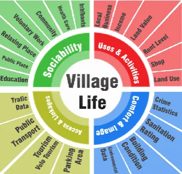
Indicators for analyzing village. One way to analyze an area is to use different types of indicators that describe the area in terms of function, structure and location [15]. Using these three large groups would require the analysis, including historical, financial, social, ecological and climate [6]. By covering the indicators of the territory, it is possible for the local community, in cooperation with the municipality, to develop a long-term strategy for the development of the territory. Sociability is one of the important indicators. The World Health Organization, along with the Office of Disease
Figure 1. Indicator groups influencing village planning (developed by the authors).
The authors believe that for the coastal areas the traditions will be one of the most essential
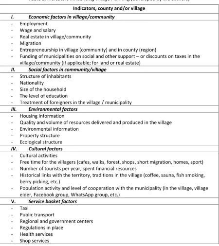
indicators for developing the territory from “sleepy” to “active and open place” with tourism possibilities. Thus, for analyzing historical places the special attention is given to the analysis of the historical development of the village, collection of its traditions and identification of sustainability for the future to integrate the traditions and culture with the developing territory. This characteristic of the village may require a unique approach with focus on different indicators, which play a great role in the image and attractiveness of the village [18]. Regarding the conducted expert interviews, the authors developed indicator groups and divided them into five subgroups (see Table 1):
• economic factors;
• social factors;
• environmental;
• cultural-historical;
• government basket service.
Economic factors design the economic development of the village or region, which must give the main information about the employment, wage and salary, real estate in village/community, migration, entrepreneurship in village (community) and in county (region). These economic factors will provide the main information about the planning of the territory development and the economic health in village and community. Based on the information obtained, the community and government can analyze the economic activities inside the village, also devoting attention to the ratio of people working outside the village. As it is known, economic factors are in synergy with social factors, such as life quality and satisfaction in the family and in the society (community), and reflect the environment of the village.
Social factors present the interrelatedness of social roles, behavior and action of local community, providing the detailed information on the people structure in the village in order to analyze the age, nationality and education. The information help identify and analyze the analytical categories and relationships between them, i.e., the needs of the village depending on the age and ethnographic view.
Environmental factors play an important role in the local territory – village through infrastructure development (public, municipal and private) by indicating its structure and housing information. Environmental factors are closely related to social factors. Environmental factors provide important information on the minimum needs to be able to live in the village:
• drinking water and sewerage;
• roads and their quality;
• energy saving possibilities;
Cultural factors present the human mentality, traditions, attitudes, beliefs, values, self-definition of local community, which are important in village planning. They can also provide information on the free time possibilities in the village and its surroundings. Despite the fact that there is no optimal parameter determining how far from village free time activities must be, the parameter serves as an attribute.
Government basket service factors provide information on the type of services one can obtain directly from the government for territorial development and they also determine the location of health, shopping, local and regional center. These factors have also restrictions on territorial development and protection zones.
Table 1. Indicators Influencing Village Planning (developed by the authors)
Indicators, county and/or village I. Economic factors in village/community
- Employment - Wage and salary
- Real estate in village/community - Migration
- Entrepreneurship in village (community) and in county (region)
- Funding of municipalities on social and other support – or discounts on taxes in the village/community (if applicable; for land or real estate)
II. Social factors in community/village - Structure of inhabitants
- Nationality
- Size of the household - The level of education
- Treatment of foreigners in the village / municipality III. Environmental factors
- Housing information
- Quality and volume of resources delivered and produced in the village - Environmental information
- Property structure - Ecological structure IV. Cultural factors - Cultural activities
- Free time for the villagers (cafes, walks, forest, shops, short migration, homes, sport) - Number of tourists per year, spent financial resources
- Historical links with the territory, traditions in the village (coffee, sauna, fish smoking, berry picking, etc.)
- Population activity and level of cooperation with the municipality (in the village, village elder, Facebook group, WhatsApp group, etc.)
V. Service basket factors - Taxi
- Public transport
- Regional and government centers - Regulations in place
- Health services - Shop services
(ES) indicators. In the further research, the authors will attempt to harmonize local level indicators (village indicators) with the ES indicators.
3.2. Methods for collecting the values for indicators and their data sources
To analyze local territories, it is possible to use methods that provide accurate and precise data. The data must cover the largest part of the area territory and most of the inhabitants. Triangulation involves the use of different methods and sources to check the integrity of, or extend, inferences drawn from the data. It has been widely adopted and developed as a concept by qualitative researchers as a means of investigating the convergence of both the data and the conclusions derived from them [10]. It is also often cited as one of the central ways of validating qualitative research evidence.
The methods for data collection are the following:
• mapping of the geospatial data – geodetic surveying on the field, the use of the geospatial databases for collecting the environmental information;
• survey – it is possible to use mutual and written methods, social forms and the GIS platform;
• interview – it is possible to collect cultural information and needs of inhabitants;
• observation – one of the oldest methods for collecting the information on the habits and behavior;
• document analysis – collecting information on the services and regulations of the government, decisions of the government and submissions.
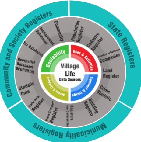
There are various data sources for information collection, from maps to databases (see Fig. 2):
• geospatial databases (textual and graphical);
• statistical databases;
• archives;
• collection on site.
Figure 2. Data sources for indicators (developed by the authors).
In this respect, in the village planning the indicators mainly focus on the local needs –people’s
combine different geospatial and analytical layers (see Fig. 2). For example, to analyze the population, it is possible to show its needs and examine possibilities in the village or its surroundings. The GIS tool should help organize the life in villages.
3.3. Methods for analyzing and visualizing indicators
It is possible to use a lot of the methods to analyze the village life. The most important methods are statistical and / or logical. For the visualization purposes, it is possible to use combination of the analytical data and cartographical maps – to use the GIS systems, statistical and / or logical methods for describing and illustrating, reducing and summarizing, and evaluating data [27]. Based on the data, these methods allow drawing inductive conclusions and separating the signal (the phenomenon of interest) from the noise (statistical fluctuations or subjective bias) in the data. GIS systems give the connection with the place and possibilities to visualize the results with the geographical place for the interaction of different data layers.
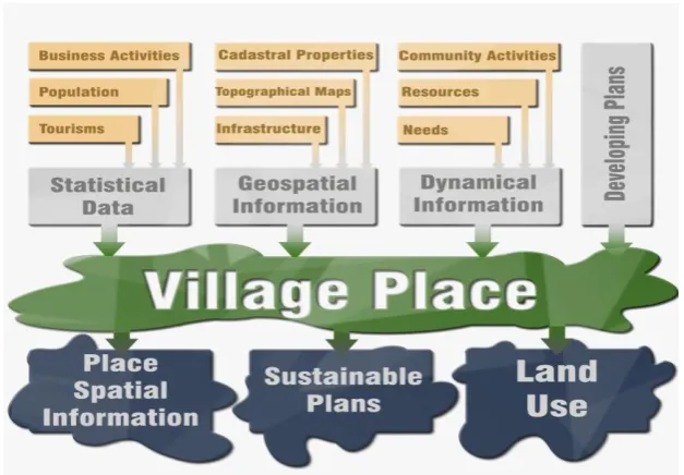
Taking into account the discussion part of the present research, the authors designed the information system architecture of the indicator analyzing tool (see Fig. 3).
Figure 3. The information system architecture of the indicator analyzing tool (developed by the authors).
According to Fig. 3, it can be stated that the results of the indicator analyzing tool must show the main possibilities for communication, needs and possibilities for the development of the village territory. The tool will allow understanding and analyzing the economic, environmental, social, service basket and cultural factors, including the scenario and forecast approach. The results can also indicate threats for sociality and economical possibilities, as well as determine the strengths of local community. In the further research regarding the village indicator analyzing tool, detailed characteristics of indicators and the use of GIS layers will be developed.
4. Conclusions
The developed methods of evaluation of economic and social processes, as well as the methods of territory evaluation are widely considered in scientific literature, but the obtained results (indicators) are used in forecasting, planning (also in local plans) and defining strategic areas of development at various levels.
Indicators are the tools that help analyze the socio-economic situation in the village. GIS system is one of the best ways to present and process statistical and geospatial information using spatial analyzing methods, e.g., geoprocessing. The indicators provide a potential contribution to the economic development of villages; smart growth in quality improvement; creation of better communities for future generations; establishment of viable communities; planning services; urban and regional planning; the development of brownfields and the way how the land development plans can be adjusted to reach results expected by inhabitants, incl. through stakeholder dialog.
Author Contributions: Conceptualization, M.K. and S.G.; Methodology, M.K.; Validation, A.L.; Formal analysis, J.H. and U.K.; Investigation, M.K.; Writing—original draft preparation, M.K.; Writing—review and editing, S.G.; Visualization, M.K.; Supervision, S.G.; Project administration, S.G.
Funding: This research was funded by the INTERREG Central Baltic Program Project Coast4us within the P2 project priority – Sustainable use of the common resources.
Conflicts of Interest: The authors declare no conflicts of interest.
References
1. Auziņš, A., & Geipele, S. Creative Destruction for Sustaining a Land Development in Residential
Areas. 2016, pp. 283-294.
2. Bently, G., & Pugalis, L. Shifting Paradigms: People-centred Models, Active Regional Development, Space-blind Policies and Place-based Approaches. Local Economy. 2014, 29(4–5), 283–294. http://dx.doi.org/10.1177/0269094214541355.
3. Bossel, H. Assessing viability and sustainability: a systems-based approach for deriving comprehensive indicator sets. Conservation Ecology 5(2): 12. 2001.
4. Cimdiņa, A. & Raubiško, I. Cilvēks un darbs Latvijas laukos. Sociālantropoloģisks skatījums. Rīga: Zinātne. 2012.
5. Clout, D.H. The Countryside: Towards a Theme Park? In D. Stone (Ed.). The Oxford Handbook of Postwar European History. 2012. http://dx.doi.org/10.1093/oxfordhb/9780199560981.013.002 8.
6. Denzin K. N, Lincoln S.Y. Handbook of qualitative research. Sage Publications the University of Michigan. 1994, 643 p.
7. ESPON. EDORA European Development Opportunities for Rural Areas. Applied Research 2013/1/2. Draft Final Report: Version 1, 30/04/2010. Part A and Part BESPON & UHI Millennium Institute. 2013, 81 p.
8. Ernsteins R., Kaulins J., Zilniece I., Lontone A. Coastal Governance Solutions Development in Latvia: Collaboration Communication and Indicator Systems. Coastal Zones. 2015 Elsevier. Chapter 7.
9. Franceschini, F., Galetto, M., & Maisano, D. Management by measurement: Designing key indicators and performance measurement systems. Torino: Springer Berlin Heidelberg. doi: 10.1007/978-3-540-73212-9. 2007, 242 p.
10. Galdeano-Gómez, E., Aznar-Sánchez, J.A., & Pérez-Mesa, J.C. The Complexity of Theories on Rural Development in Europe: An Analysis of the Paradigmatic Case of Almera (South-east Spain). Sociologia Ruralis. 2011, 51(1), 54-78. http://dx.doi.org/10.1111/j.1467- 9523.2010.00524.x
11. Gallopin, G.C. Indicators and their use: Information for decision-making. In: Moldan, B. and Billharz, S. (Eds), Sustainability Indicators. Wiley, New York. 1997, pp. 13–28.
12. Gollana, N., Voyer, M., Jordan, A., & Barclay, K. Maximising Community Wellbeing: Assessing the Threats to the Benefits Communities Derive from the Marine Estate Ocean and Coastal Management. 2019, 168., 12–21. https://doi.org/10.1016/j.ocecoaman.2018.10.020
Methodological Proposal for a Multidimensional Fuzzy Index in the Mediterranean Area Sustainable Development Goals Indicators. 2008.
14. Hopkins, T.S., Bailly, D., Stottrup, J.G. A Systems Approach Framework for Coastal Zones. Ecology and society. 2011, 16(4): p.25.
15. Kalibatas, D. The Multi-Attribute Assessment of Environmental Factors Influencing on Dwelling-houses. Summary of Doctoral Dissertation. Vilnius Gediminas Technical University. Vilnius: Technika. 2009, 22 p.
16. Kārkliņa, R. Lauku kopienu, pašvaldību un valsts iestāžu sadarbība attīstības plānošanā. No A. Cimdiņa, & I. Raubiško (Sast.). Dzīve, attīstība, labbūtība Latvijas laukos. Rīga: Zinātne. 2012a, 67
– 87.lpp.
17. Kārkliņa, R. Vai laukos ir pilsoniskā sabiedrība? No B. Bela, & B. Zepa (Zin.red.). Identitātes.
Kopienas. Diskursi. Rīga: LU Akadēmiskais apgāds. 2012b, 47 – 60. Lpp.
18. Lovrić, N., & Lovrić, M. Network Approach to Constructing Theory of Participation in Spatial
Planning. Land Use Policy. 2018, Vol. 79, pp. 30–47.
https://doi.org/10.1016/j.landusepol.2018.07.038
19. Meadows, D., (Ed.). Indicators and Information Systems for Sustainable Development. Sustainability Institute, Hartland Four Corners, Vermont. 1998.
20. O’Briena, M., Wechslerc, D., Bringezub, S., Rüdiger Schaldachb, R. Toward a systemic monitoring of the European bioeconomy: Gaps, needs and the integration of sustainability indicators and targets for global land use. Land Use Policy 66. 2017, 162-171.
21. Momtaz, S., & Zobaidul Kabir, S. M. Evaluating Environmental and Social Impact Assessment. in Developing Countries (Second Edition). Evaluating Environmental and Social Impact Assessment in Developing Countries. Chapter 6 - Evaluating Community Participation in Environmental Impact Assessment. 2018, pp.123 – 140. https://doi.org/10.1016/B978-0-12-815040-5.00006-1 22. O’Brien, M., Tsiropoulos, Y., Smets, E., Forsell, N., Valin, H., Lindner, M., Moiseyev, A., Verburg,
P., Verhagen, W., Bringezu, S.,2014. Tools for evaluating and monitoring the EU bioeconomy: indicators. Deliverable 2.2 of the SAT-BBE Project. Supported by the European Commission. 23. Parker, D.C., Manson, S.M., Janssen, M.A., Hoffmann, M.J., Deadman, P. Multiagent systems for
the simulation of land-use and land-cover change: a review. Annals of the association of American Geographers 93 (2), 2003, 314–337.
24. Project for Public Spaces. 2016. https://uploads ssl.webflow.com/5810e16fbe876cec6bcbd86e /5a626855e27c0000017efc24_Healthy-Places-PPS.pdf
25. Project for Public Spaces (2016). https://www.pps.org/
26. Pudzis, E., Geipele, S., & Geipele, I. Community Participation in Village Development: The Scale of Latvia. Baltic Journal of Real Estate Economics and Construction Management. 2016, Vol. 4, pp. 84-99. doi:10.1515/bjreecm-2016-0007
27. Reveiu A., Dârdală M. Techniques for Statistical Data Visualization in GIS. Informatica Economica vol. 15, no. 3/2011. 2011, p.72.
28. Future Trends in the Baltic Sea. 2010. http://assets.wwflv.panda.org/downloads/wwf_future_t rends_in_the_baltic_sea_2010_1.pdf.
29. M. Meyerson, E.C. Banfield. Politics, planning, and the public interest. New York: Free Press; 1955.
30. Holms, J., Arhipova, I., Tulbure, I., Vitols, G. Ecosystem Provisioning Services Automated Valuation Process Model for Sustainable Land Management, Procedia Computer Science, 65–72. doi: 10.1016/j. procs. 2017.01.063.
31. Cano, E. L. et al. A strategic decision support system framework for energy-efficient technology investments. In TOP. Springer Berlin Heidelberg, 25(2), 2017, pp. 249–270.
32. Holms, J., Arhipova, I., & Vitols, G. Linking environmental data models to ecosystem services’