CHAPTER FOUR:
THE URBAN MORPHOLOGY OF LONDON'S RAILWAY TERMINUS AREAS,
THEIR URBAN PHYSICAL PATTERNS
This chapter is the first in a series of urban scale studies of London's railway termini.
This first chapter will focus upon the morphology of the terminus areas in terms of the
physical structure of the built form. This will be complemented in the following
chapter by the, perhaps, more sophisticated analysis of morphology offered by
Hillier’s configurational approach. This chapter starts by investigating the mutual
physical impact of the terminus buildings and their related structures on their urban
contexts. Through a figure and ground study, the research focuses on the
morphological evolution of all London's terminus areas, since before the arrival of the
railway lines up until the present time, and discusses how they relate to their current
urban conditions, introduced in Chapter One. The aim of this study is to isolate a
potential urban mechanism intrinsic to the development of both blighted and vital
terminus areas that could suggest an objective approach to transforming them
successfully from nodes into places in the city.
The study in this chapter is structured into three sections. The first section presents
a historical review of the development sequence of London's termini. This will address
the influence of the different railway companies that were responsible for their
distinctive locations and layouts, leading to a situation in which the termini now exist
as an ellipse bounding the inner London area. The review uncovers the logic behind the
siting and layout of each terminus, which has subsequently affected the evolution of its
urban setting. The second section presents the figure and ground study of all London's
terminus areas in three successive historical periods; in the early 19th century, before
the termini were built, toward the end of that century during the period of urban
consolidation, and finally at present time. In some station locations, where
redevelopment projects are in progress, their future urban physical patterns will also
be analysed. The last section will discuss this ongoing relationship between the
terminus structures and their evolving urban settings as well as how the present
4.1: DEVELOPMENT OF LONDON'S MAINLINE RAILWAY TERMINI:
A Historical Review
This first section addresses the historical development of London's mainline railways
and their terminus stations since the early 19th century. Its objective is to investigate
how the termini became embedded in the city structure as a consequence of their
initial siting and layout by the railway companies. The development of London's
railways will first be reviewed to establish a broad picture of how the rail
infrastructures were imposed upon the city. This will contextualise the development
sequence of London's railway termini, their different locations in the city and
strategies chosen, before introducing a summary of the relationship between the
termini and the city's super-grid.
4.1.1 An overview on the development of London's railways
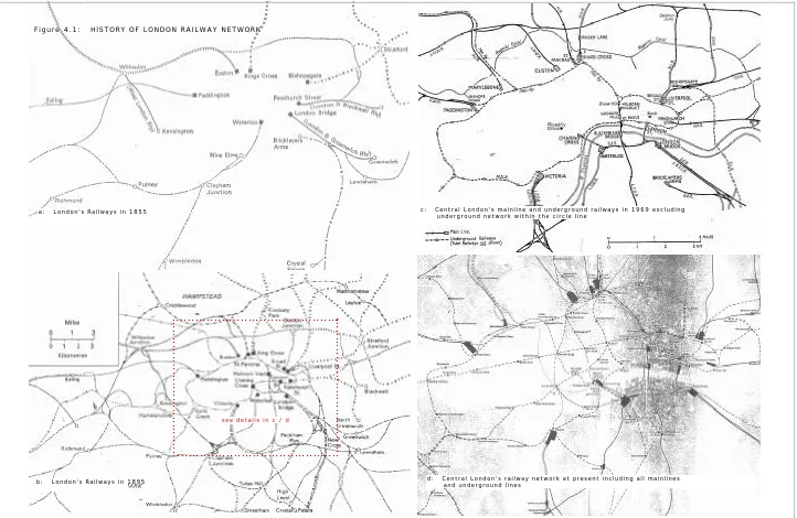
Seaman (1973) notes that the history of London's railways begun in the mid 19th
century with lines approaching from all directions to what was then effectively the
city’s edge (Figure 4.1a ). Not until almost half a century later were they rapidly connected by more suburban lines to accommodate expanding suburban settlements
and goods transportation (Figure 4.1b ). However, the central core of London was still left free from over-ground railway lines (Figure 4.1c ), only to be covered by the fine mesh of the underground network in the early 20th century (Figure 4.1d). The underground network interconnected all central mainline railway termini in order to
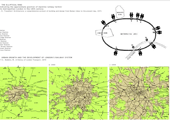
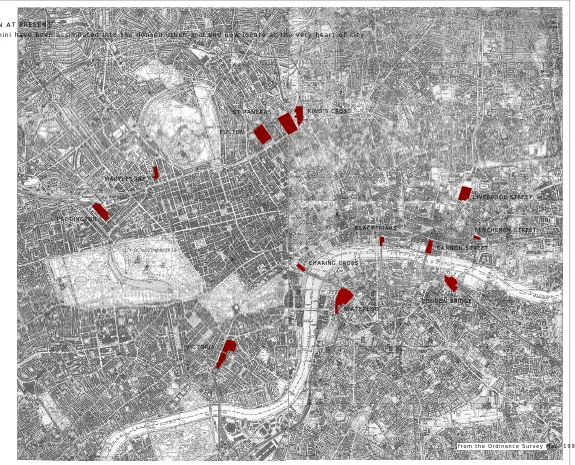
relieve the traffic congestion of the urban core. In Figure 4.2, Holland (1971) illustrates that the railway stations built at the end of London's mainline railways
seem to describe the form of a roughly elliptical ring at the edge of inner city.
Paddington, Marylebone, Euston, St.Pancras, King’s Cross, Liverpool Street and
Fenchurch Street Stations are upon the northern perimeter, while the southern
perimeter is linked by Victoria, Waterloo and London Bridge Stations. Charing Cross
and Cannon Street Stations were placed a little deeper into the ring at its southeastern
corner.
Three London maps by Barker and Robbins (1974), shown in Figure 4.3 , depict how periods of urban growth related to successive periods of extensive railway development
during the mid 19th to the mid 20th centuries. They clearly show that the location of
railway lines and their stations were not arranged from the very beginning in
lines themselves that directed the corridors of outward urban growth. Barker and
Jackson wrote in their book, London: 2000 years of city and its people (1974) that
London's railways both served existing places but mostly created new communities.
For example, the North Kent line was approved by a parliamentary committee in 1846
because it believed a large number of houses would be encouraged. The Railway Town
consisted of eight hundred residences beyond Wimbledon and Raynes Park, built after
the opening of Kingston-on-Railway Station. Other evidence of new London suburbs
built following the railway lines are described in several books including Wilcox and
Richard's London: the Heartless City (1977), Inwood's A History of London (1998),
and several others. This relatively unplanned development remained common only
until 1933 when the London Transport Board initiated integrated planning and
expansion for all London's railways (Pawley and Paoletti, 2000 ).
Jackson (1969) notes that the siting and layout of London's mainline railways and
their termini were a result of individual railway companies’ selections, with the
technicalities of the railway’s operation primarily in mind, the relation of the termini
to their urban context being very much an after thought. Due to the financial
constraints of the railway companies, they tried to ameliorate the disturbance caused
by railway construction to the existing neighbourhoods as much as possible. This was
to minimise the costs of demolition of housing and compensation along the construction
path as well as to avoid the unnecessary technical costs of too many level crossings
(Perkin, 1970 ). Nevertheless, the construction of some of London's railway lines caused extensive demolition to densely built-up areas in several locations.
4.1.2 The development sequence of London's mainline railway termini in
the city fabric
4.1.2a The first terminus
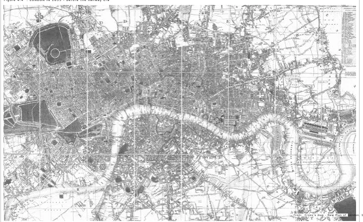
The arrival of London's first railway line to London Bridge is illustrated in Cross’s
New Map of 1835 (Figure 4.4 ). It was the London and Greenwich Railway, the first conventional line reaching the city from the Southeast. The line opened between
London Bridge and Deptford, built on a straight diagonal line with four miles of
elevated viaducts across a highly developed area of Southwark and Southeast London.
The raised level viaducts crossed over several roads and drainage ditches, including
Road and Vauxhall Bridge to the north of the Thames, and Lambeth, Newington,
Walworth, Southwark and Bermondsey to the South with a population of one million
(focus on London 98, 1998 ). Clout (1999) notes that at that time the countryside was still visible at the city's edge.
4.1.2b Railway Mania; series of termini are built up to the city's edge
London in the mid 19th century, shown in Benjamin Rees Davies' Exhibition Map of
1851 (Figure 4.5), had just gone through ‘Railway Mania’, a period of extensive railway construction that lasted from 1844 to 1847. Although London had not
expanded greatly from the period when its first railway line was built sixteen years
earlier, during this time eight more termini were built, both at the city’s edge and
within its already built-up areas. The London termini constructed during this period
are Euston Station (1837), Paddington Station (1838), Shoreditch Station (1840, later
renamed Bishopsgate in 1846) and Fenchurch Street Station (1841). The lines
approaching Euston and Paddington Stations were laid out on more or less ground
level because they were built on the edge of built-up areas. Paddington Station was
the terminus of the Great Western Railways, coming into the city from the northwest
through clay cuttings alongside the canal. The area was then mostly vacant and
considered the very western edge of London. The lines leading to Bishopsgate Station
and Fenchurch Street Station ran on viaducts of brick arches crossing through dense
settlements.
In the south, where property was neither fashionable nor valuable, after London Bridge
Station, Waterloo Station was built right up to the bank of the river Thames in 1848.
The terminus ended the London & Southampton line, extended from Nine Elms Station
which was built ten years earlier at Nine Elms Lane, just south of Vauxhall Bridge.
Passing through the built-up areas of Lambeth and Vauxhall, the 1.75 mile line to
Waterloo Station was built on brick viaducts. Another minor terminus, Bricklayers
Arms Station, was constructed relatively nearby at the south of London Bridge Station
in 1844 to relieve its cramped condition (Jackson, 1969 ). The extensive railway development then greatly accelerated the city’s expansion, especially from 1849
onwards as the railway companies began to encourage people to live away from the city
by offering extraordinary fare concessions (Collins, 1964 ).
The most recent terminus shown in the 1851 map is King's Cross Station. It was built
under the Regent's Canal through the Gas Works Tunnel just before reaching the
terminus. King's Cross Station was respectfully built on the frontier limit set up by
the Royal Commission on Railway termini in 1846. The Commissioners, reporting on
railway termini within or in the immediate vicinity of London's metropolis, ruled
against schemes bringing railway lines into the heart of London. The main objection
was the prospect of large number of travelers that railways would have brought into the
central area if more termini were allowed to built, and the effects that this would have
on congestion levels in the city’s centre. They set up a restricted area bounded by The
Edgeware Road, Marylebone Road, Euston Road, Pentovile Road, City Road, Finsbury
Square, Bishopsgate, Gracechurch Street, London Bridge, Borough High Street, Borough
Road, Lambeth Road, Albert Embankment, Vauxhall Bridge, Vauxhall Bridge Road,
Grosvenor Place and Park Lane, to limit the invasion by more railway construction
(Perkin, 1970 ).
The next map of London depicts the city in 1905 (Figure 4.6 ). It shows two more termini that were built in accordance with the Royal Commission's restricted central
area. St.Pancras Station (1868) and Marylebone Station (1899) were built to the north
of the frontier limit. St.Pancras Station was the terminus of the Midland line which
approached at ground level from the south of Camden Square, through the ‘slums’ of
Agar Town and finally crossed over the Canal and the Fleet River. This necessitated
the platforms and the terminus to be twenty feet higher than the level of Euston Road to
its front. Marylebone Station's approach lines were built in a combination of
underground tunnels, covered ways, and open areas, finally bridging over Regent's
Canal before following a gradient to the street level where the terminus was located.
4.1.2c Invasion to the city centre at last
However, Broad Street Station (1865) and Liverpool Street Station (1874) were
exceptions to the 1846 frontier limit. The projects within central London were
specially allowed by the 1863 Committee but on the condition that the approach lines
would be below street level in order to avoid additional land acquisition. The lines
were intended to bring suburban traffic in from the north and the east, while the
existing Bishopsgate Station was converted into a goods station. Despite the low-level
approach, the construction of the Great Eastern Railway to Liverpool Street Station
necessitated the demolition of 450 tenement dwellings and consequently squeezed the
former inhabitants into adjacent streets, worsening the capital's poorest and most
On the south side of the river the Royal Commission allowed greater freedom to railway
construction because of the lower property values, and the fewer main roads to be
crossed in the less trafficked street system of the south. Following London Bridge
Station a couple of decades earlier, the Brighton & South Coast Railways also managed
to construct their West End terminus at Victoria Station in 1860. Its precise location
was determined by the road bridge and Southwark Water Works immediately to the
east. The bridge which carried the line across the river was the first railway bridge
across the river Thames in London. The line beyond the bridge descended steeply to
the level of the Grosvenor Canal before reaching the terminus, built on the vacant site
of the canal basin at the western end of Victoria Street. The approaching rail line was
mostly covered by a glazed roof in order to be invisible as much as possible to the
newly-laid-out Belgravia and Pimlico neighbourhoods a few hundred metres away from
Buckingham Palace, which belonged to aristocratic and influential landowners (Jackson,
1969 ). The 1846 ‘forbidden zone’ was also invaded by two more termini at the north bank of the river, Charing Cross Station (1864) and Cannon Street Station (1866).
Both occupied bridgehead positions and were constructed without extensive demolition
to existing property.
The communication between the capital’s mainline railway termini was achieved in
1863 by the Metropolitan Railway, an 'inner circuit' link located just north of the
river. To avoid traffic disruption in central London, it was decided to build
underground and so the Metropolitan Line became the world's first underground
railway. The line at first linked only Paddington and King's Cross Stations. By 1913,
a completely circuitous communication link with all other termini (except Fenchurch
Street Station ) was achieved with the electrified ‘tube’ railways, as well as by motor
buses and taxicabs which were common by the early 1900s (Jackson, 1969 ).
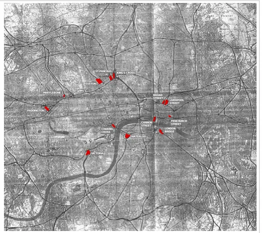
Figure 4.7 shows all twelve of London's mainline railway termini, now standing amid the city's densely built-up areas, each of which has changed greatly from its initial
structure at the time of the siting and layout in the 19th century. London has
expanded enormously from the time of the first railway intervention. Besides the City,
it now includes 32 Boroughs covering over 600 square miles with a population of
4.1.3 The relationship between London's termini and the city's global structure
Figure 4.8 illustrates how each of London’s railway termini relates to the city's supergrid drawn from the network of trunk and main roads on the 1999 Ordnance
Survey Map. The map displays the predominantly ground level termini and approach
lines in yellow, the elevated ones built on viaducts in blue and the sections of the
mainline railways constructed below ground in brown. It is clearly shown that the
northern termini; Paddington, Marylebone, Euston, King's Cross and St.Pancras
Stations, are all ground level termini located along the perimeter of Marylebone and
Euston Roads, which appear to form the northern part of the supergrid. From the
historical review, all of these stations were initially constructed on approximately
ground level since the sites were only moderately built up at the time the railways
arrived, with the exception of St.Pancras Station.
The elevated London termini built on brick viaducts; Charing Cross, Waterloo, Cannon
Street, London Bridge and Fenchurch Street Stations, are grouped to the south side,
scattered along both banks of the river Thames in a less orderly arrangement than the
northern perimeter. They are linked with one another by elevated railway viaducts,
including the Thameslink route via Blackfriars through-station which connects
northwards to King's Cross Station. Only Fenchurch Street Station stands isolated
away to the east. It is clear that all elevated railway termini in the south appear to
reach deeper into the inner urban area. Historically, this is because London's
Southwest area had less valuable properties and restrictive planning regulations than
the other sites. However, as the area was densely built-up before these termini were
constructed, building on viaducts was conceived as a way to avoid the extensive cost of
demolition along the construction paths.
Victoria and Liverpool Street Stations are the only two ground level termini which
also break into the core area. For both, construction was allowed within the 1846
Royal Commission's central forbidden zone, and as the construction site of Victoria
Station was then still vacant, the terminus was able to be located at ground level.
However, its structure was largely covered due to the sensitive urban surroundings.
On the far side of the city Liverpool Street Station was not as fortunate. Building
through a densely built-up area forced the terminus and its railway lines to be built
below ground level.
It also appears that London’s railway termini always locate themselves next to at least
Stations. These termini were set back from, but still within easy reach of, the main
grid. Marylebone Station is on Melcombe street, a more local route in the area and
only a block away from the main street, Marylebone road. Euston and Paddington
Stations can be accessed from the main roads to their fronts, Euston Road and Praed
Street respectively, but Euston Station is set back behind Euston Square Garden and a
bus station, while Paddington Station is located behind the Great Western Hotel.
Despite several entry points from the surrounding streets, the station’s main frontage,
which is usually marked by a grand gateway, is always opposite the approach lines
from the perspective of passengers alighting from trains and moving toward the city.
Most of London's mainline railway termini appear to have their frontages aligned along
main streets except Liverpool Street and London Bridge Stations. Liverpool Street
Station has its frontage on Liverpool Street, a smaller road compared to Bishopsgate
Street flanking its east side. London Bridge Station turns its side to Tooley Street, the
main street in the area. However, some termini such as Waterloo and London Bridge
Station have networks of railway lines passing along their frontages.
The different locations and layouts as well as the geographical characteristics of all
termini have made the areas distinctive from one another. How this affected the
evolution of their local urban surroundings will be discussed in the next section.
4.2: THE CHANGING MORPHOLOGY OF LONDON'S RAILWAY TERMINUS AREAS
The study in this section focuses on a more local scale by examining the evolution of
the urban physical pattern in each of London's railway terminus areas. As
demonstrated by the previous historical review, London termini have different siting
and layouts according to availability of land for the railway companies and the
conditions of the existing areas. In such distinctive circumstances at each station
location the next question is, how have the terminus structures, including the station
buildings, their approach lines, goods sheds, marshalling yards, etc., affected the
urban physical pattern of their surroundings and vice versa throughout their history?
4.2.1 Method and scope of study
Rossi (1982) argued that the study of an urban pattern over time reveals how certain
linking it to another. In order to examine if there is any common physical structure
and order to London's terminus areas that would potentially explain their diverse
vibrant or blighted conditions, a 'figure and ground study' will be used. The method
represents public spaces in an urban area as a two dimensional field of urban blocks;
land covered by buildings, 'figure', and open voids, 'ground'. Both elements are called
by Rowe and Koetter (1978) and Krier (1979) the 'urban fabric' whose transformation
will reveal how an area has evolved. Transik (1986) argued that the transformation can
be traced by examining the changing relationship between these two fundamental
elements; how the figure and ground are added, subtracted, or altered in their physical
geometry and subsequently affect change in the overall pattern. The transformation
are approached through a two dimensional abstraction in plan view, focusing on size,
pattern and orientation. The figure and ground study in this chapter will focus on how
the terminus structures have taken part in the transformation of their urban settings
and vice versa in successive periods of time.
As already discussed in Section 1.2, the area of the figure and ground study will be
delimited by the boundary around each station building within a walkable radius of
five hundred metres, or a 'ten-minute walk', with further case-specific justification
according to local topography, such as the major street grids or the river. St.Pancras
and King's Cross Station areas will be examined as a single area, since not only are
they located adjacent to one another and share an Underground train platform, but the
areas to their rear are also largely incorporated into one vast and vacant piece of land.
In order to trace out the urban pattern of each terminus area in three important
periods of their history, the figure and ground study in this chapter will be based on
the London maps of three successive periods, 1835, 1888 and 1995. According to the
historical review of London's railways in Section 4.2.2, the beginning of the railway
era was in 1836 when the first line reached London Bridge at the city's edge from the
southeast. The 1835 figure and ground maps represent what all terminus areas in
London were like prior to the arrival of the railway structures.
The second set of maps represent the terminus areas in 1888, which was almost the end
of the first century of London's railways and several decades after the period of
Railway Mania (1844-1847). Most of the termini, except Marylebone Station (1899),
were already built and their urban settings had mostly been developed. The 1888
maps depict most terminus structures in their original forms being surrounded by
densely built up urban areas. This is just before the period of dramatic change that
termini demolished and extensively reconstructed in order to cope with the new
railway operating system. The elimination of steam also meant new opportunities for
the development of the railway properties. The 1888 maps then represent the
beginning of the decline of London's railways when they were considered increasingly
redundant, to be later largely replaced by road and air transportation in the early
20th century which subsequently brought about the great transformation of London
terminus areas. It also coincides with the period of urban deterioration as well as the
extensive clearance of London's slum areas.
The third set of figure and ground maps from 1995 represent the areas' urban pattern
at the present time. Not only is this the period after such dramatic change occurred in
the early 20th century but it is also post-dates several other important events that
have affected London's urban fabric such as the wartime devastation (1940s), the
post-war rebuilding programmes (1950s onpost-ward) and especially the big leap of urban
redevelopment as a consequence of the years of the Big Bang in 1985-1986 which also
marked the return of London's railways. Additionally, the prospective figure and
ground urban pattern of those areas where redevelopment is currently underway will
also be examined. These include the office and commercial development at London
Bridge and Waterloo Stations, the hotel and commercial development at Victoria
Station, the ongoing phase of Broadgate Complex Development at Liverpool Street
Station and the ongoing Paddington Basin Development at Paddington Station.
The three maps selected are Cross's 1835 New Plan of London, Bacon's 1888 New
Large-Scale Ordnance Atlas of London and Suburbs and The 1995 Ordnance Survey Map of
Greater London. Building coverage in the areas that are depicted as 'figure' are
colored in black and exterior spaces in white representing the 'ground'. As Cross's
and Bacon's London maps do not produce areal surveys of as great a precision and
detail as the Ordnance Survey map, the comparison of figure and ground patterns
tracing from these three maps will focus only on their general transformation, not on
the precise geometrical scale of the figure and ground elements.
The study will also be accompanied by a historical overview of the terminus areas
briefly addressing social, economic and other development factors related to their
evolution including the review of ongoing or prospective redevelopment projects that
4.2.2 The figure and ground study of London's railway terminus areas
The local maps and their figure and ground study of all London's eleven railway
termini are illustrated in Figures 4.9 - 4.19 , starting from Euston Station, the first terminus built in the city, then following in clockwise direction Holland's 'elliptical
ring' of termini, previously shown in Figure 4.2, from King's Cross and St.Pancras, Liverpool Street to Fenchurch Street, London Bridge, Cannon Street, Waterloo, Charing
Cross, Victoria, Paddington and finally, Marylebone Station areas.
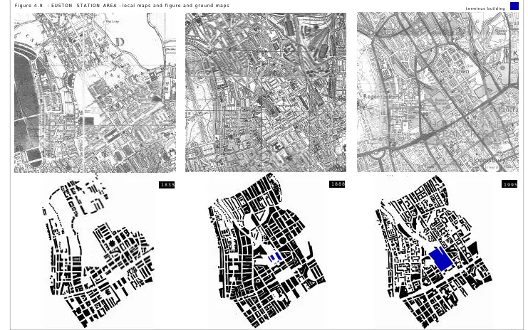
4.2.2a Euston Station area
The 1835 figure and group map of Euston Station area (Figure 4.9a ) depicts a sparse field of building blocks with the vast vacant space of Euston Grove in the Somers Town
area before the arrival of Euston Station two years later. Apparently, the urban
pattern which was overlaid diagonally from the outset has been maintained until the
present day. At the time, New Road, later named Euston Road, that ran across the
east-west axis to the south of the station's site, was already well constituted by buildings
and crossed with one large rectangular square. The standard urban blocks in the area
were small terraced town houses, established primarily in a network of streets and
squares. Some residential blocks in the Bedford estates at the south side of New Road
had been laid out since 1770s.
The 1888 figure and ground map shows the initial structure of Euston Station in blue
(Figure 4.9b ). The original terminus, built in 1837, is relatively small compared to the current one. The area had by then been completely developed and throughout its
building coverage became relatively more dense. The urban fabric consisted of
edge-defined building blocks of predominantly terraced houses built during the 1850s with
open squares of various shapes. Some were semicircular, such as the squares at
Mornington Crescent. These voids generally appeared to be 'figural’ as they were
carved out of the urban solids. The area was inhabited a cross-section of London
society, from the most moneyed to the most deprived (Jackson, 1969 ). The station's approach lines demarcated a diagonal linear gap in the northern neighbourhood.
However, the gap was quite narrow and the continuity of the urban grid on both sides of
the tracks was still maintained. The areas along Euston Road, Drummond Street and the
railway yards were constituted by large blocks of office buildings built from 1881
onward. The area at the south of Euston Road had become more concentrated than that
to the north by large blocks of several campus buildings. These are University College
The overall ensemble of urban figures appears to be looser at present especially
around the station's rear, as depicted in the 1995 figure and ground map (Figure
4.9c). The edge-defined blocks along both sides of the tracks, seen in the previous map, have now been replaced by smaller blocks of free-standing council flats and other
housing scattered in the landscape. Only some street-defined building blocks with
carved out open squares have survived such as those in Clarendon Grove (1894) and
Churchway area (1895). New flats were constructed as a compensatory provision for
people who whose dwellings were demolished by the incursion of rail lines in existing
residential areas here and elsewhere. Some council houses were built during the post
war period (Jackson, 1969 ). The rebuilt Euston terminus is now seen as a distinctively large figural block standing out from its surroundings. The linear urban void caused
by the railway lines has become wider and the urban fabrics alongside them appear to
be separated into two sides. However, they are densely distributed and coherent with
each other. The station's frontage along Euston Road and beyond are still well
constituted by large office blocks. The Bloomsbury area in the south has not changed
very significantly. It still has been occupied by the edge-defined building blocks of
university, hospital and residential buildings. Euston Station area has no plan for any
large scale station related urban development1.
4.2.2b King's Cross and St.Pancras Station area
Located between the City and the West End, before the arrival of King's Cross and
St.Pancras Stations the area was considered a London suburb. Its 1835 figure and
ground map shows the terminus area still to be a vast and vacant space sparsely filled
by small building blocks (Figure 4.10a ). These were medieval parishes, churches, pubs, and industries of various kinds such as brick, tile and gas companies (Askew In
Greed, 1996 ). The urban fabric generally consisted of a field of building blocks laid coherently along Euston Road, the area's major east-west axis, and along the
intersection of Euston, Gray’s Inn, King's Cross, Pentonville, Caledonian Road and York
Way. The built up area was defined by Grand Union Canal at the north side dissecting
the area since the 1820s (Thorne, 1997 ).
The site of King's Cross Station itself was initially occupied by small building blocks
belonging to the London Small Pox Hospital, while the site of St.Pancras Station was
previously occupied by blocks of family housing built in 1848 to accommodate working
class people once crammed into the city centre. This accommodation was among the
first blocks of family flats ever built in London (Jackson, 1969 ). The 1888 map (Figure
4.10b ) shows King's Cross and St.Pancras Stations having been imposed onto the area in 1851 and 1868 respectively. Both lie to the north of the Euston Road which was then
considered the limit decreed by the government to prevent more termini reaching
further south into the centre of London, as previously discussed in Section 4.2.2b. At
the time when both termini were built, the area had already been built up. The railway
construction then necessitated the demolition of many industries in the area,
including the whole community of small tenements of Agar Town (Jackson, 1969 ).
It was the organisation of complex rail lines reaching both termini and the east-west
crossing of the north London line that formed the large triangular open void of
approximately sixty acres, clearly shown in both figure-ground maps of the last two
periods. The large void is also crossed by the Regent's Canal (seen in the original
maps) and filled with some urban blocks belonged to railway related industries. The
northern part of the site contained a rail depot for goods interchanging and packing
and other uses including warehouses, the Granary, the German Gymnasium, the
workhouse hospital and the gas holders built since the 1880s (Davis, 1997 ). The void has completely disrupted the urban fabric on both sides.
In the 1995 figure and ground map (Figure 4.10c ), although the void is still large and in evidence, its edge has become more diffuse and invaded by other urban blocks. Some
small blocks of residential flats have been built, especially in the north around Agar
Grove, Caledonian Road and Barnsbury, replacing the unused parts of the railway lines
and goods depot. The rail depot at the centre of the void was replaced by a larger block
of concrete batching works and some storage spaces (Thorne, 1997 ). Designated as a conservation area dominated by the Grade I listed stations and old warehouse blocks,
parts of the southern area of the site have remained almost unchanged. Similarly to
Euston Station area, the overall urban figural pattern at both sides of the King's
Cross-St.Pancras railway land appears to have loosened and been occupied by more
fragmented and smaller urban blocks. These are principally council flats and houses
constructed during the post war period in the areas of Camden Town, Somers Town and
Pentonville. At the west side of St.Pancras Station, the vacant site formerly occupied
only by the Somers Town's goods depot has been replaced by the new British Library
Only the neighbourhoods to the front of both termini located to the south of Euston
Road appear to maintain more or less the same urban density and pattern. However,
since 1995 the large housing redevelopment by King's Cross Estate Action has begun in
the area bounded by Euston Road, Judd Street, Tavistock Place and Gray's Inn Road
(Crook, 1996 ). The area is now occupied by more loosely packed residential blocks.
There have been several masterplans to redevelop the King's Cross railway land since
the 1980s. Their prime objective is to integrate the Channel Tunnel Rail Link (CTRL)
interchange which is an international rail transport network with associated urban
redevelopment intended to promote local benefits. The project is now on hold as the
CTRL deal has not yet been finalised, despite several detailed implementation plans
put forward by different parties2. However, the schemes were finally held back as they
were criticised for being an office-led development rather than a mixed-use project to
address the needs of local people (Bertolini and Spit, 1998 ). The development consortiums finally appointed King's Cross Partnership (KCP) as the main working
group, mostly consisting of local authorities. Their aim was to formulate a strategic
framework for the redevelopment relating to the local and regional urban and
transportation issues rather than to conceive of a rigid masterplan as in the past. The
process is planned to take until after 2004 so there is still no finalised scheme for the
King's Cross railway land redevelopment and the site remains the largest urban void in
the city.
4.2.2c Liverpool Street Station area
The existing site of Liverpool Street Station shown in the 1835 figure and ground map
(Figure 4.11a ) had already been densely built up with street-defined urban blocks. The grid pattern of the area had continuously evolved from the junction of the
important Roman roads of Old Street and Kingsland Road located north of the terminus
area (Hawkes and Harrison, 2000 ). The main thoroughfare cutting the area in half is Bishopsgate, linking north-south from Kingsland Road to the City. The terminus area
2 They include the redevelopment schemes independently established by King's Cross Railway Lands Group (KXRLG), King's Cross Team (KXT) and London Regeneration Consortium (LRC). More details of the development schemes for King's Cross Railway Lands can be found in; Bertolini and Spit (1998), Cities on Rails, Crook, (1996), Change at King's Cross, King's Cross Estate Action, A Vision for London Report, (1997), King's Cross: past, Present and Future. LRC proposed a masterplan designed by Foster and Partners with the support of British Rail, the developers and minority landowners in July 1990, and in collaboration with Space Syntax Laboratory, University College London. The detail Space Syntax study can be found in, Hillier et al. (1988), The Other Side of the Tracks, The King’s Cross railway lands site in its
urban context, Hillier et al. (1992), The Kings Cross Project, a study of passenger behaviour, Space Syntax Laboratory
was where the two perpendicular sets of urban grids came together, and was generally
occupied by well-to-do Georgian residential communities and was at the time
considered a suburb area known as Shoreditch and Spitalfields. The communities were
laid out on the existing grid network during the 17th century with few alleys and
courtyards (Inwood, 1998 ). The area declined sharply during the Victorian age and became deprived and crime ridden neighbourhoods (Clout, 1999 ). The site of the terminus building itself is ten acres previously occupied by blocks of old Bethlehem
Hospital.
Because the area had already been built up, the arrival of railway lines to Bishopsgate,
Broad Street and Liverpool Street Station in 1846, 1865 and 1874 respectively could
not avoid but demolished large numbers of buildings along the construction path. This
included the City of London Theatre, gasworks and some 450 tenement dwellings
housing seven thousand people. Some of these who could not afford to settle elsewhere
squeezed into the adjacent streets and the area became yet more deprived (Clout, 1999 ). Bishopgate Station was later turned into a goods station after the later arrival of the
other two termini. The 1888 figure and ground map (Figure 4.11b ) shows the area had been scarred by the twisting pattern of railway tracks approaching these three
termini, evidenced as a series of linear urban gaps. The widest was located to the west
and north sides of Broad Street and Liverpool Street Station. The east side of Liverpool
Street Station was still attached to some residential blocks, later demolished in 1890
to allow for the station extension.
The urban pattern of the station area in 1888 was at its most dense and congested. It
was the time shortly before the overcrowding due to a large number of immigrants
coming into inner London areas around 1900 thus worsening the already acute urban
deprivation. The map also shows the new Commercial Street diagonally cutting through
the area from the northwest to the southeast crossing the rail lines as a major
thoroughfare since 1845. It was initially aimed to cut right across the notorious slum
areas around Wentworth Street (Inwood, 1998 ).
The area was heavily bombed in 1917 and 1941 and slum clearance was further carried
out by the Peabody Trust during the 1920s-1930s. The area has largely been rebuilt
with a modern mixed use of office, business and residential blocks. The 1995 figure
and ground map (Figure 4.11c ) reveals a dramatic change of urban pattern from the previous map. Now the area has a more loose urban pattern of edge-defined building
blocks and figural voids. The latest map also sums up the area's physical pattern
1980s to the north and west side of Liverpool Street Station. The site of Broad Street
Station and the large gap at the station's back are now filled with more coherent urban
blocks with a series of open squares which appear to integrate the urban fabric on
either side of the terminus structure well with each other. Broad Street Station's
former approach line which is no longer used is left as a flat-topped embankment still
clearly visible as a narrow gap running northward from the former station. However,
the line is elevated on a series of viaducts and does not intervene in the street grids.
Nevertheless, there remains a large gap caused by the abandoned Bishopsgate Station
and the rail lines approaching Liverpool Street Station from Shoreditch at the northeast
corner. The urban fabric on both sides appears to be disconnected from each other.
After the completion of the Broadgate Complex's early phases (1-8) in 1990, its later
phases (9-13) are now being constructed, again using the air rights above the rail lines
as office, residential and commercial spaces to the north of Exchange House on
Primrose Street (Figure 4.11d ). There are also more office developments being constructed in the station area including the Spitalfields office and retail development
and several new housing projects located around the railway embankment. Another
small project called 'the Viaducts Goods Yard' is also being implemented by
reclaiming the vacant space of the disused railway viaducts further down the tracks for
a new retail strip, local market place and sports ground for the Bangladeshi
community. The new viaduct market is located to the west of Brick Lane and aimed to
be an extension from its weekend market and a new connection to Wheler Street. The
location of all these new developments are plotted on the station's local area map shown
in Figure 4.11e . Its figure and ground study (Figure 4.11f ) reveals that the urban fabric around the terminus building becomes relatively denser throughout, but
especially to its rear. The void caused by the approaching rail lines appears to be
entirely overcome and the urban fabric on either side become united without any sign
of the railway structures. The large void further north is also projected to be narrowed
being taken up by the new market space.
4.2.2d Fenchurch Street Station area
Fenchurch Street Station was the first terminus built within the City of London. The
1835 figure and ground map (Figure 4.12a ) shows evidence of an already dense urban pattern before the arrival of the terminus in 1841. The pattern was relatively coherent
and established along two main thoroughfares in the area, Leadenhall and Fenchurch
Cheapside. Most urban blocks in the area were residential and industrial buildings
densely packed along tiny alleys off the main streets. They were merged with a
shipping quarter serving the docks and the estuary at the southern end of the plan,
which was densely latticed with small streets and lanes approaching the river Thames.
The largest void in the area is around the Tower of London and at St.Katherine's Docks.
As the area had already been built up, the Railway company opted to build the
terminus structure on a series of elevated viaducts. The terminus building was sited
just to the south of Fenchurch Street, east of Mark Lane. The railway structures had
apparently very little impact on the existing urban fabric as shown in the 1888
figure-ground map (Figure 4.12b ). Only a new street called Railway Place was cut to give access to the station's front entrance. The urban grid at the station's rear area had not
been interrupted since it still continued beneath the viaducts. The urban pattern by
that time was generally at its densest, especially in the Tower Hill and Whitechapel
areas located to the north and south of the terminus. The areas had accommodated more
industries and immigrants and become significantly poverty-stricken (Inwood, 1998 ).
The 1995 figure and ground map (Figure 4.12c ) shows that Fenchurch Street station is still well assimilated and almost unnoticed in the map despite its structural expansion
in 1935 and 1962. The terminus structures almost disappear under the proliferation
of office buildings that sprang up in the second half of the 20th century. The station
building itself was built over to provide more office spaces. The overall urban pattern
in the area, especially within the City wall, has not changed very much as most of the
new buildings largely replaced the existing ones retaining their same footprints. Some
old blocks were only refurbished to accommodate new functional uses such as banks,
insurance offices, warehouses and production houses (Cassidy In Burdett, 1994 ).
In the area outside the City wall, its urban pattern has become looser. Most old
warehouses that survived the German bombing of the 1940s were closed down and some
were either refurbished or replaced by residential uses built in smaller blocks. There
is also a more apparent linear urban gap further down the railway lines which is
caused by the railway viaducts being fenced off especially around Cartwright, John
Fisher and Chamber Streets. The blocked viaducts have disconnected the urban fabrics
on either sides. They are attached with some vacant pocket spaces or fenced off
parking lots. Apparently, the areas further down the railway lines have more sparsely
4.2.2e London Bridge Station area
Figure 4.13a shows the 1835 figure and ground map of London Bridge Station area which is located in Borough, between Southwark and Bermondsey. The building blocks
had begun to constitute along three main streets in the area; Tooley Street, running
east-west parallel to the Thames with small alleys packed with industrial factories and
warehouses approaching the wharves to the north; Bermondsey Street, running
diagonally from the southeast corner with a series of differently sized urban blocks
relating to it; and Borough High Street, the centre of business and trading in the area
with small alleys inhabited by poor trade-labourers. The urban pattern in the area
within these three main streets was still sparse. The areas were largely occupied by a
series of pleasure gardens, entertainment resorts and spas (Davies, 1987, Hawkes and
Harrison, 2000 ).
The first railway line to London terminated at London Bridge Station in 1834. The
station was sited just to the east of Borough High Street, between Tooley and St.Thomas
Street. Its approach tracks were built on a series of viaducts diagonally across the
built up area. The tracks continued to run through Southwark, snaking off towards
Waterloo Station before curving round onto the Cannon Street Bridge to Cannon Street
Station. The tracks produced a series of linear gaps seen in the 1888 figure and
ground map (Figure 4.13b ) because of the large bundles of railway structures both at the front and back of the station building. As the arrival of the railways in the area
brought along busy wharves and more tenements, the whole area had then become
progressively more densely packed with blocks of industrial, residential and
warehouse building. Its social condition had become worse due to bad drainage leading
to an unpleasant smell (Inwood, 1998 ).
The station was rebuilt in the 1970s and later refurbished in the 1990s. It now
accommodates platforms for both terminus and through station's under one roof. Its
overall structure appears to be the largest building block in its surroundings as
depicted in the 1995 figure and ground map (Figure 4.13c ). The map also represents London Bridge Station area after the docks were closed down and parts of Bermondsey
were redeveloped under the Docklands regeneration scheme. Some areas were
devastated by the German bombing during the 1940s and later rebuilt as residential
housings and council flats. The urban pattern has apparently become more sparse with
free-standing blocks scattered in open ground rather than street-defined urban
blocks. Only Guy's Hospital complex, located to the south of the terminus, has
restored and converted into small units of accommodation, shops and restaurants such
as at Butler's Wharf, or replaced by office blocks or luxury flats during the 1990s.
The linear gap caused by the space taken up by the approaching rail lines has become
more apparent in the 1995 map. It appears to become wider as it also includes some
pocket spaces which are either vacant or fenced off for parking lots. Similar to
Fenchurch Street Station area, some of London Bridge Station's railway arches have
been blocked or converted into storage, garages or small businesses so the urban fabric
alongside them are largely disconnected.
The drastic regeneration of London Bridge Station area was proposed by Renzo Piano in
2000 and initially due to be completed in 2006. The scheme includes the
redevelopment of a new retail, office and residential complex on top of the terminus
building, boasted to the be the tallest high rise structure in Europe, and the
refurbishment of the station's concourse and platform areas as well as its viaduct
spaces to improve the accessibility from its surrounding streets and to increase retail
and other urban facilities (Figure 4.13d-e ). The large vacant riverside areas resulting from the demolition of the docks is now the site of the new headquarters for
the Greater London Authority, completed in 2002, and the ongoing construction of a
medium rise office complex (Figure 4.13f ). The prospective figure and ground pattern of London Bridge Station area in the near future, shown in Figure 4.13g , reveals the denser and more coherent urban pattern along the riverside area. The linear gaps
taken up by the railway lines still cause scars in the urban fabric and become more
apparent as their surroundings get denser.
4.2.2f Cannon Street Station area
The 1835 figure and ground map of the area before the arrival of Cannon Street Station
(Figure 4.14a ) shows the once commercial heart of London built over a maze of medieval lanes and alleys. Major market streets in the area, Newgate Street and
Cheapside, run on east-west axes and fan out towards the north and the east.
Bishopsgate is another main road linking from the north to the City and all the way
down to London Bridge. The general urban pattern was dense with edge-defined urban
blocks. The important ones were the Guildhall Complex, guild buildings and parish
churches including some prestigious houses with large courtyards well embedded
throughout the plan, while the southern part was cross-cut by a denser lattice of small
streets and lanes close-packed with small blocks of wharves lying along the Thames.
The arrival of a new river bridge and viaducts brought in railway lines to Cannon
Street Station in 1866. The 1888 figure and ground map (Figure 4.14b ) shows how the terminus building and its approach lines fit well into the urban grid since its initial
stage. It was sited just to the south of Cannon Street with its elevated platforms
crossing over Upper Thames Street. Its elevated tracks were immediately carried away
onto Cannon Street Bridge. There was no interruption to the existing street grid and
the terminus structures were totally assimilated and almost unnoticed in the figure
and ground map. This is due to its topographical advantage since the terminus was
sited just slightly beyond the river bank. By that time, there were two more new
streets, Queen Victoria Street and King William Street, cutting diagonally across the
area to the north of the station. The site of Cannon Street Station then appeared to be
more or less in the middle position to the south of the City's major intersection. The
overall urban pattern was constituted by street-defined building blocks latticed with
small alleys and lanes. Areas along the riverfront appear to be even more packed with
small linear blocks of wharves than the previous map.
The 1995 figure and ground map (Figure 4.14c ) depicts the terminus area in a looser pattern with larger urban blocks. As the arrival of the railways had encouraged a
large proportion of the work force to take up suburban residence, Londoners became
increasingly daily commuters travelling to work in the city. Most of the old building
blocks have been replaced by larger blocks of banks, insurance offices, warehouses
since around the end of the 19th century. The station building itself was heavily
bombed in 1941 and was rebuilt in 1957, addressing also the need for longer train
platforms (Jackson, 1969 ). The station's arch roof was removed and topped over with office space with a roof garden and the terminus building is now totally hidden under
the new development. The river bank warehouses, breweries, markets such as
Billingsgate, Leadenhall markets, including buildings such as Bracken House, Royal
Exchange, Custom House and Fishmonger Hall, were either refurbished, rebuilt or
4.2.2g Waterloo Station area
The area of north Lambeth and Southwark before the construction of Waterloo Station
had been sparsely built up, as shown in the 1835 figure and ground map (Figure
4.15a ). The urban pattern was generally made up of small blocks of residential, commercial and industrial uses constituted along Waterloo Road which runs straight
from Waterloo Bridge and also the other roads cut in parallel with the bend of the
Thames; Bleeder, York, Baylis and Kennington Roads. The area along the riverfront at
north Lambeth was occupied by small blocks of pottery industries on the open grounds
of timber yards while Southwark's riverside was filled with wharves and breweries
(Davies, 1987, Inwood, 1998 ). The large urban void located in the south is the area of Lambeth Palace built in the 12th century.
The construction of elevated viaducts carrying rail lines to Waterloo Station was
completed in 1848. The construction had demolished some seven hundred houses along
its path as it had tried to avoid important buildings such as Lambeth Palace, Vauxhall
Garden and gasworks, and ended up crossing over twenty one roads in total (Jackson,
1969 ). Shown in the 1888 figure and ground map (Figure 4.15b ), the linear gap taken up by the railway lines were evidenced as far north as Waterloo Road where the
terminus was sited on ten acres of land over eight streets, miscellaneous hay stalls,
cowyards, dungheaps and a large pond. The general urban pattern was already dense
and the area was considered one of the most deprived residential neighbourhoods in
London (Inwood, 1998 ). Although the urban fabric at both sides of the railway lines appear to be coherent with each other as the street grids could still be continued under
their viaducts, the area in general was very much scarred by the viaduct structure
itself. The linear gaps are evidenced at the station's rear by its approach lines and at
the front by the bypass lines from Charing Cross Station.
The urban pattern of the terminus area depicted in the 1995 figure and ground map
(Figure 4.15c ) changes enormously from the 1888's. The area has comprehensively been replanned and redeveloped since the mid 20th century. Like other areas in inner
London, it experienced overcrowding and accumulative decay toward the end of 19th
century and was heavily bombed during the 1910s and the 1940s. The congested slums
in the area had been cleared and replaced by council flats, governmental and office
blocks. In 1951, the Southbank area, north of the terminus, became the site of the
Festival of Britain and was later replaced by the Southbank cultural complex,
consisting of auditoriums, concert halls and an art gallery. The river bank once lined
institutional blocks such as St.Thomas Hospital and County Hall, later redeveloped as
the London Aquarium. Another large scale office development is The Shell Centre,
built in 1962 on the site adjacent to the terminus on York Road. The overall urban
pattern along the riverside has then become looser with large urban blocks with
several open spaces placed in between them.
Waterloo terminus was extensively rebuilt and extended to accommodate more rail
platforms including those of the new trans-European rail links, the Eurostar service.
The voids taken up by the railway structures appear to become wider both at the front
and the back sides and their attached urban solids become more fragmented due to
their occupation by loose blocks of council housing and flats. Similar to Fenchurch
Street and London Bridge Stations, some of the Waterloo's railway arches have been
blocked or turned into garages, warehouses or storage, such as the ones along Hercules
Road south of the terminus. Some were later closed down due to dampness and water
leakage problems and remain a physical barrier to the urban fabric on both sides of
the tracks.
There is a future refurbishment and redevelopment plan for Waterloo Station being
studied by Nicholas Grimshaw3 who designed the Waterloo International Station. The
scheme is to move the currently elevated station's concourse hall down to ground level
in order to improve the accessibility from its surrounding streets and to extend the
length of rail platforms into the existing concourse area. A fifty five storey office
building is also planned to top the station structure. However, its detailed
implementing plan has not yet finalised. Additionally, the riverside Jubilee Gardens
next to the London Eye to the west of Waterloo Station is now being developed by Rick
Mather Architects as a new arts quarter consisting of concert halls, theatres, cinemas,
an arts school and cultural organisations as well as new public squares (Figure
4.15d-e). The accessibility of pedestrian routes to and through the Southbank area will also be improved. The prospective urban pattern of Waterloo Station area shown in the
latest figure and ground map (Figure 4.15f ) reveals that the riverside vacant lot of Jubilees Garden is filled in while the urban scar caused by the terminus structures
still remains unchanged as the Grimshaw's station redevelopment plan neither utilizes
the air rights above the approach lines nor aims to reconnect the areas alongside the
tracks, but takes up only the space over the existing terminus building.
4.2.2h Charing Cross Station area
The area before Charing Cross Station depicted in the 1835 figure and ground map
(Figure 4.16a ) was dominated by edge-defined urban blocks with a large open space, Trafalgar Square, constructed in 1830. The area is a junction where major streets come
together such as The Strand, Whitehall, Pall Mall, Charing Cross and St.Martin’s Lane.
All of them had already been well constituted by urban blocks by 1835. The area
along the riverfront east of The Strand and Whitehall, the two main thoroughfares
cutting parallel to the sharp bend of the Thames, was largely occupied by river palaces
and mansions, one of which remains, Somerset House. The other important building
blocks are several governmental offices, The National Gallery, Northumberland House,
Covent Garden Market and entertainment businesses such as gaming houses and
theatres (Davies, 1987 ). The site of Charing Cross Station itself was formerly occupied by Hungerford Market located to the east of The Strand just beyond the river bank.
Similar to Cannon Street Station, Charing Cross Station, which was opened in 1864, has
caused very little interruption to the existing urban grid. Depicted in the 1888 figure
and ground map (Figure 4.16b ), the terminus was assimilated well into the its surrounding. There was no sign of an urban scar as the terminus structures had been
placed on elevated viaducts. The lines were immediately carried across the Thames on
the new Hungerford Bridge, named after the former Hungerford Market. A new
riverfront street, Victoria Embankment, was constructed along the bend of the Thames
running underneath the Charing Cross viaducts and the relationship between the urban
fabric and the river has since been disconnected. Northumberland House was also
demolished in the 1870s giving way to Northumberland Avenue, another approach
street to Trafalgar Square from the riverside. Leicester Square, another important
open square in the area, was apparently constituted by building blocks after Charing
Cross and Shaftesbury Avenue were tidied up and improved in the 1870s (Davies, 1987 ). By that time, the square was surrounded by dense blocks of residential use, theatres
and music halls (Hawkes and Harrison, 2000 ). Another open void apparently seen in the map is the Covent Garden Market.
The 1995 figure and ground map (Figure 4.16c ) depicts the current urban pattern of the terminus area which has not changed much during the past century. Most building
blocks have only been refurbished or infilled to accommodate more offices, hotels and
especially entertainment businesses since the 1930s (Hawkes and Harrison, 2000 ). The terminus itself has been refurbished several times including in the 1900s, from its
time destruction of 1914 and 1941, and finally in the 1980s, the large scale
redevelopment of commercial and office spaces, Embankment Place, using air rights
above the terminus building and its railway lines. Apparently, these developments
have had very little effect on the station's surroundings and the overall urban pattern.
4.2.2i Victoria Station area
Belgravia as shown in the 1835 figure and ground map (Figure 4.17a ) before the arrival of Victoria Station was only sparsely built up with small blocks of residential
uses. Defined largely by watercourses, the area was still generally vacant, consisting
of low-lying ground used for horticulture that was latticed with water channels
irrigating and draining the productive fields. Natural inlet of water at the time
stretched as far north as the present site of Victoria Street (Davies, 1987). Buckingham Palace Road was then the only main thoroughfare in the area connecting Buckingham
Palace to the riverside in the south. The site of Victoria Station itself was still vacant
and formerly occupied by the old Grosvenor Canal Basin used for conveying materials
and essentials for freight transport to Belgravia and Pimlico. Several blocks of
sawmills and small wharves lay along the canal bank north of Ebury bridge (Davies,
1987 ).
As shown in the 1888 figure and ground map (Figure 4.17b ), the diagonal urban pattern became more apparent as the grid was completely filled up with edge-defined
blocks of residential buildings, mostly of influential and aristocratic landowners
(Davies, 1987 ). Some were built around open squares such as Eccleston Square and Warwick Square located to the east of the terminus. The grid had evolved from old
ancient tracks designated to maximise return per acre by Thomas Cubitt (Barker and
Jackson, 1990 ). Victoria Street was constructed in 1851 and later became a major street linking Belgravia to Whitehall and Westminster, flanked with large blocks of mansion
flats, retail units, hotels and offices. Victoria Station, built later in 1860 over the
existing canal, had its railway lines placed below street level. Despite a long linear
gap caused by the railways, the street grid could still continue over the tracks. There
were some small and fragmented residential blocks that occupied the narrow area
between the tracks and Buckingham Palace / Ebury Bridge Road alignment.
The terminus was extended to accommodate its Brighton platform in 1908. Shown in
as a linear gap along their route, the areas on both sides of the tracks maintain a
coherently diagonal urban pattern. In the 1980s, there was a large scale office and
commercial development, Victoria Place, built over the westernmost rail platforms and
a part its approach lines. This is seen as a figural block at the station's back side
flanking Buckingham Palace Road. However, the area's urban pattern in general
remains more or less the same. Some urban voids have been filled in by more building
blocks such as the Chelsea Barracks to the southwest of the terminus on the site of
Ranaleigh Garden and around the cluster of streets newly created in the late 19th
century such as Ashley Place, Carlisle Place and Morpeth Terrace (Barker and Jackson,
1990 ). Along Victoria Street, several blocks were reconstructed during the post war redevelopment to accommodate more commercial uses but the new structures were then
built on more or less the existing footprints of the old blocks.
Victoria Station has a redevelopment scheme being implemented through a detailed
plan by Railtrack. The plan is to develop a new hotel and commercial complex over the
station's concourse space including a new office complex at its eastern frontage along
Wilton Road. The bus station which is now located at the station's front side will be
moved in order to give way to the new station forecourt. The new bus station will be
incorporated with the newly developed office building. The prospective development
spaces are marked in grey onto the 1995 map (Figure 4.17c ) which shows that the area's urban physical pattern is not affected by the new construction.
4.2.2j Paddington Station area
Paddington Station area shown in the 1835 figure and ground map (Figure 4.18a ) was still largely vacant. Only some residential blocks had been built up along Edgeware
Road and Bayswater Road as well as the street grids located in between them. The area
was still considered suburban being largely occupied by small private villas along
Regent's canal and beyond.
The first stage of Paddington Station was built in 1838 as a small timber construction
sited alongside the canal of Paddington Basin, its front on Praed Street. The urban grid
began to form itself around the railway structures, its approach lines and a temporary
station that branched off just to the north before the terminus. The 1888 figure and
ground map (Figure 4.18b ) shows the construction of the Brunel's ironwork station building that replaced the original one in 1854, with Great Western Hotel built at its
area had been relatively built up and the urban void caused by the railway structures
had become more apparent. The urban pattern of the areas alongside the void appears
to be distinctive from each other. The southern part was densely built up with
edge-defined rectangular blocks of terrace houses with a series of carved out squares in
different shapes and sizes, all corresponding to a diagonal street grid. Some of these
blocks were occupied by hotel businesses that came along with railways, especially in
Bayswater. The area had also been filled in with boarding houses, privately occupied
mews, Victorian residential blocks overlooking Hyde Park and a shopping mall (Clout,
1999 ). The northern area around Paddington Basin which was cut across by Grand Union Canal was occupied by small blocks of wharves and scattered blocks of
semi-detached villas especially around Warwick Avenue. It had later become an area of
poverty and the major factor of such decline was noted to be largely the influence of
the railway line itself that cut into the area (Davies, 1987, Clout, 1999 ).
Depicted in the 1995 figure and ground map (Figure 4.18c ), the Westway (A40) reinforced the urban division even more than that the railway structures and Grand
Union Canal had already done during the last century. Although it was built as an
elevated highway and allows the existing street grids to continue beneath its structure,
the construction of The Westway largely demolished the area north of Paddington Basin
and separated a large vacant piece of land, previously a goods depot, from its
neighbourhoods. The gap then appears to become larger, disconnecting the urban
fabric of the areas alongside the track even more severely. The slum areas around
Paddington Basin and Warwick Crescent that were demolished during the 1960s have
been replaced by new clusters. The urban pattern at the north side of the Westway has
largely become a sparse field of free-standing blocks, while at the south side, it
remains more or less unchanged. Only some blocks of terraced houses were replaced
by council flats such as at Hallfield Estate along Bishopbridge Road and around
Norfolk Crescent, Oxford Square and Cambridge Square.
The Paddington Basin Development, now being constructed with its first phase due to
be completed in 2003, is currently the largest urban development project in London.
The development area comprises the station building itself, 13 acres of Paddington
Basin north of the terminus, 11 acres of Paddington Goods yard located between the
rail lines and The Westway, St.Mary's Hospital area north of Praed Street and the area
at the eastern end of the Canal Basin by the corner of Praed Street and Edgeware Roads.
The project includes approximately 720,000 square metres of mixed use development
including transport facilities, offices, residences, commercial uses, hotels, hospitals,