i
SPATIOTEMPORAL MODEL FOR LANDSCAPE ECOLOGICAL ASSESSMENT IN LANDSCAPE PLANNING
WAN YUSRYZAL BIN WAN IBRAHIM
A thesis submitted in fulfilment of the
requirements for the award of the degree of
Doctor of Philosophy (Urban and Regional Planning)
Faculty of Built Environment
Universiti Teknologi Malaysia
iii
Specially dedicated to all.
iv
ACKNOWLEDGEMENT
Alhamdulillah, I am grateful to the Allah S.W.T for the good health and wellbeing
that were necessary to complete this PhD study. Peace and blessing of Allah be upon the prophet Muhammad (S.A.W), his family, companions and all those who follow his footsteps, Ameen.
I wish to express my sincere thanks to all that supporting me during my study.
Firstly, I would like to express my sincere gratitude to my supervisor Prof. Dato’ Dr. Ahmad
Nazri bin Muhamad Ludin for the continuous support of my Ph.D study for his patience,
v
ABSTRACT
vi
ABSTRAK
vii
TABLE OF CONTENTS
CHAPTER TITLE PAGE
DECLARATION ii
DEDICATION iii
ACKNOWLEDGEMENTS iv
ABSTRACT v
ABSTRAK vi
TABLE OF CONTENTS vii
LIST OF TABLES
LIST OF FIGURES
LIST OF APPENDICES
LIST OF ACRONYMS
xiv xvii xxiv xxv
1 INTRODUCTION 1
1.0 Introduction 1
1.1 Research Backgroud 4
1.2 Problem Statement 7
1.3 Research Questions 9
1.4 Research Aim and Objectives 10
1.5 Significance of Research 11
1.6 Scope of Research 11
1.7 Research Outline 13
1.8 Thesis Organization 18
2 ECOLOGICAL IMPORTANCE AND SPATIOTEMPORAL
LANDSCAPE CHANGE
viii
2.0 Introduction 21
2.1 Landscape Ecological Resource: Theories, Function and Application In Landscape Planning
22
2.1.1 Landscape Ecological Resource Definition and Ecological Interraction
22
2.1.2 The Siginificance of Landscape Ecological Function
25
2.1.3 The Role of Landscape Structure For Ecological Function Integrity
27
2.1.4 Ecological Landscape Consideration In Landscape Planning Theory
32
2.2 Landscape Change and Ecological Consequence 36 2.2.1 Landscape Change; Urbanization and
Agriculture
37
2.2.2 Ecological Impact On Landscape Change 39 2.2.2.1 Fragmentation and Homogenisation
of Natural Landscape Areas
40
2.2.2.2 Natural Landscape Area Change in Malaysia
44
2.2.2.3 Edge Effect; Reduction of Core Natural Area Quantity, Quality and Habitat Suitability
48
2.3 Summary 55
3 SPATIAL DYNAMIC MODELLING AND APPLICATION
IN LANDSCAPE CHANGE
57
3.0 Introduction 57
3.1 Ecological Analysis in Spatiotemporal Landscape Change 58
3.2 Spatial Dynamic Modelling in Landscape Ecological Consideration
62
ix 3.2.2 Spatial Landscape Ecology Modelling and GIS
Application
70
3.2.3 Spatial Dynamic Modelling In Landscape Ecology Application
74
3.2.3.1 Overview of Spatial Models 76
3.2.3.2 Markov Chain Model 77
3.2.3.3 Multi-criteria Evaluation 78
3.2.3.4 CA_Markov Model 79
3.3 Incorporating of Ecological Assessment Tool in Spatiotemporal Landscape Change
80
3.3.1 Landscape Index 80
3.3.2 Data Acquisition in Ecological Landscape Assessment
82 3.3.3 Integrated Consideration on Landscape
Ecology in Landscape Change
83
3.4 Summary 84
4 METHODOLOGY AND SPATIAL MODEL
DEVELOPMENT
85
4.0 Introduction 85
4.1 Model Design and Development 86
4.2 Landscape Change Identification 91
4.3 Prediction of Landscape Change Probabilities 92 4.3.1 Land Use and Land Cover Change Spatial
Relationship
93
4.3.2 Future Landscape Change Probability 96 4.3.3 Identification of Rules and Probability of Area
Changes
99
4.4 Spatiotemporal Landscape Change Simulation 101 4.4.1 Cellular Automata Based Simulation 101 4.4.2 Validation of Rules and Simulation 103
4.5 Landscape Ecological Assessment 104
x Analysis
4.5.2 Composition Landscape Ecological Analysis 108
4.5.3 Core Ecological Area Analysis 109
4.6 Selection of Study Area 111
4.6.1 Population, Density and Ethnicity 113 4.6.2 Urbanization and LULC in Iskandar Malaysia 116 4.6.3 Ecological Planning Framework in
Development of Iskandar Malaysia
123
4.7 Database Design and Data Preparation 128
4.7.1 Database design 128
4.7.1.1 Land Use and Land Cover 130 4.7.1.2 Physical characteristics 130 4.7.1.3 Proximity to Land Use,
Infrastructure and Facilities
131
4.7.1.4 Strategy and policy dimension 132 4.7.2 Data collection, Database development and
Data Processing
132
4.7.2.1 Land Use and Land Cover Map Preparation (Satellite Image Processing)
134
4.7.2.2 Geophysical Database Development
138
4.7.2.3 Urban and Natural Landscape Change
139
4.7.2.4 Proximity of Variables 140 4.7.2.5 Delineation of Strategy and Policy
Dimension Data
141
4.8 Summary 142
5 SPATIOTEMPORAL LANDSCAPE CHANGE IN
ISKANDAR MALAYSIA
144
5.0 Introduction 144
5.1 Spatiotemporal Historical Land Use and Land Cover Change
xi 5.1.1 Performance of LULC Classification and
LULC Composition
145
5.1.2 LULC Change from 1994 to 2000 147
5.1.3 LULC Change from 2000 to 2007 151
5.1.4 LULC Change from 2007 to 2013 154
5. 2 LULC Change Behaviour and Characteristics 156 5.2.1 Scenario of Characteristics in LULC Change 156 5.2.2 Landscape Change Behaviour and Magnitude 163
5.2.2.1 Urban Landscape Change Correlation
163
5.2.2.2 Natural Landscape Change Correlation
167
5.3 Projection of LULC Change 169
5.3.1 Transitional of LULC in Future Change 170 5.3.2 Suitability Area Identification for Future
Landscape Change
174
5.4 Spatiotemporal of Future Landscape Change 177 5.4.1
5.4.2
Future LULC between 2013 and 2020 Future LULC between 2020 and 2025
178 182 5.4.3 Future LULC between 2025 and 2030 185 5.4.4 Overall Spatiotemporal of future landscape
change in Iskandar Malaysia from 2013 to 2030
188
5.5 Summary 190
6 ECOLOGICAL LANDSCAPE CONSEQUENCE IN
SPATIOTEMPORAL LULC CHANGE
192
6.0 Introduction 191
6.1 Spatiotemporal Analysis of Landscape Change Pattern 193
6.1.1 LULC Change Analysis 193
6.1.2 Urban Growth Pattern Analysis 195
6.1.3 Urban Growth Characteristics in Different Development Zones
xii 6.2 Spatiotemporal of Ecological Landscape Structure
Change
206
6.2.1 Configuration of Ecological Landscape Change 210 6.2.1.1 Intertidal forest areas landscape
structure change between 1994 and 2030
215
6.2.1.2 Inland forest landscape change between 1994 and 2030
224
6.3 Edge Effect and Ecological Function Evaluation 227 6.3.1 Depth of Influence and Ecological Edge
Response
228
6.3.2 Core Ecological Area Degradation 233 6.3.2.1 Intertidal Forest Area Implication 238 6.3.2.2 Inland Forest Area Implication 242
6.4 Summary 243
7 DISCUSSION AND CONCLUSION 245
7.0 Introduction 245
7.1 The Implication of Development Plan Dimension Towards Spatiotemporal Landscape Change
246
7.2 Ecological Structure and Function Change 250
7.2.1 Ecological Value Destruction 250
7.2.2 Ecological Service Degradation 253
7.2.3 Edge Effect and Core Ecological Area 255 7.3 Achievement and Contribution of the Study 257
7.3.1 Integration of Spatiotemporal LULC in Landscape Ecology
258
7.3.2 Enhancement of GIS Model Capability in Landscape Change Analysis
261
7.3.3 Statistical Method in Quantifying Landscape Change and Ecological Assessment
263
xiii Adaptive Management
7.4 Limitation of the Study and Future Research 269
7.5 Improvement and Future Research 271
7.6 Conclusion 272
REFERENCES 274
xiv
LIST OF TABLES
TABLE NO. TITLE PAGE
2.1 Examples of selected studies on spatiotemporal landscape change implication due to urban expansion and
agriculture activity at the different countries 42 2.2 Selected studies of land use and land cover
change and natural landscape degradation at
regional and local levels in Malaysia 46
3.1 Basic type of models 66
3.2 Ecological models and description of
functions 67
3.3 Selected studies on spatial dynamic modelling in landscape planning with
ecological consideration 75
3.4 Matrix table of criterion-alternative 78
4.1 List of variables included in the logistic
regression model 95
4.2 Ratio scale for PCM 98
4.3 The indexes used in quantifying natural
landscape configuration 107
4.4 The indexes used in quantifying landscape
composition 108
4.5 The indexes used in quantifying core area
landscape characteristics 110
4.6 Total of jurisdiction areas under different
xv 4.7 Percentage of built up areas in all
sub-districts under different local authorities 118 4.8 Comparison of urban land uses composition
of Iskandar Malaysia between 2008 and
2025. 120
4.9 Type of data and the sources of data 133
5.1 The performance of accuracy assessment based classification on LULC between 1994
and 2013 146
5.2 Land covers composition in Iskandar
Malaysia between 1994 and 2013 147
5.3 Historical transition of land use change
from 1994 to 2013 158
5.4 Coefficient table for independent variables in relationship with the urban land use
change from 2007 to 2013 164
5.5 Coefficient table for independent variables in relationship with natural landscape
change from 2007 to 2013 168
5.6a Transition probability of LULC change in
2020 171
5.6b Projection transition of LULC change in
2020 (hectares) 171
5.7a Transition probability of LULC change in
2025 172
5.7b Projection transition of LULC change in
2025 (hectares) 172
5.8a Transition probability of LULC change in
2030 173
5.8b Projection transition of LULC change in
2030 (hectares) 173
5.9 Spatiotemporal future landscape change in Iskandar Malaysia region from 2015 to
xvi 5.10 Transition of spatiotemporal landscape
change between 2013 and 2030. 181
6.1 Results of spatial matric calculation on urban pattern in Iskandar Malaysia region
between 1994 and 2030 197
6.2 Development zones boundary and
sub-districts 201
6.3 Natural landscape composition areas in the
study area between 1994 and 2013 207 6.4 Natural ecological landscape zones in the
study area 211
6.5 The distance (meters) of influence for the land covers towards natural landscape area
(forest). 213
xvii
LIST OF FIGURES
FIGURE NO. TITLE PAGE
1.1 The study process 13
2.1 The resource continuum 24
2.2 Ecological services for human and surrounding
environment benefits 27
2.3 Geometric figures indicate the shape of ecological patches with with monotonously increasing LSI (Landscape Shape Index) values
29
2.4 The concern of the ecological structure and
function in landscape ecological study 34 2.5 Fragmentation of Natural Forest Cover in
Peninsular Malaysia (1954-2000) 45
2.6 An illustration of how edge effect can reduce core ecological area in various size of natural landscape patch (adopted from Franklin, 1992
and Joan Voller, 1998) 49
2.7 An illustration of how natural landscape structure configuration influences the stability of core ecological area due to edge effect. (A) A circular natural patch tends to have a greater protection on core ecological area. (B) An irregularly shaped tends to have more edge and less core ecological area (adopted from Joan
Voller, 1998 49
2.8 The edge effects at regional scale and their
influence distances (kilometres) 51
2.9 The edge effects at towards natural landscape
xviii 2.10 Edge effects on literature review divided into:
(A) forest structure, (B) tree mortality, (C) forest microclimate and (D) biodiversity
disturbance categories 53
3.1 The trend of focus of ecological impact on
biotic and abiotic consequences 59
3.2 The concentration of edge effects studies in
relation to land use and land cover change 59 3.3 Spatiotemporal landscape change studies in
relation to ecological landscape structure and
function assessment from 2000 to 2016 61 3.4 The use of landscape metrics in international
peer-reviewed scientific papers: (a) evaluation of LULC pattern or changes; (b) habitat functions; (c) regulation functions; (d)
information functions 81
4.1 The framework of the study 87
4.2 Temporal data analysis for landscape changes
in Iskandar Malaysia 91
4.3 Relationship of MCA and GIS in decision
making process 99
4.4 The contiguity filter used in this research 102 4.5 The process of analysis and components
involved in spatiotemporal land use and land
cover change analysis 102
4.6 Landscape ecological assessment in
spatiotemporal landscape change in this study 105 4.7 Iskandar Malaysia region and context areas 112 4.8 Boundary of management areas for different
local authorities in Iskandar Malaysia region 113 4.9 The population projection of Iskandar Malaysia
by local authority 114
4.10 Population growth in Iskandar Malaysia region
xix 4.11 Composition of ethnics in 2006 for Iskandar
Malaysia region 115
4.12 The policy dimension for the development of
Johor Bahru from 1996 to 2011 117
4.13 The land use of Iskandar Malaysia in 2008 119 4.14 Urbanization promotion area in Iskandar
Malaysia region 120
4.15 Land use of Iskandar Malaysia in 2025. 121
4.16 The current massive development projects that directly replace the ecological landscape areas
in Iskandar Malaysia region. 122
4.17 Environment Sensitive Area in Iskandar
Malaysia region 124
4.18 Blue and Green Corridor in Iskandar Malaysia
region 125
4.19 Edge effects towards natural areas due to urban development and landscape mosaic change in
Iskandar Malaysia 126
4.20 Natural and agriculture areas change to build up
areas in Iskandar Malaysia 127
4.21 The components of spatial data involved in this
research 129
4.22 Series of SPOT-5 satellite images of Iskandar
Malaysia 135
4.23 Coordinate registration process for the satellite
images 135
4.24 Mosaic process and extraction of images
according to the boundary of study area 136 4.25 The classified images show the land cover of
the study area 137
4.26 Geophysical spatial data involved in this study 139 4.27 The urban growth areas and natural landscape
area loss in the past periods between 2007 and
xx 4.28 Distance of independent variables calculated in
logistic regression analysis 141
4.29 Land use policy for development and protection
zone 142
5.1 Comparison of classified images with land use
data for accuracy assessment 146
5.2 Land cover map of Iskandar Malaysia region in
1994 148
5.3 Land cover map of Iskandar Malaysia region in
2000 150
5.4 Land cover map of Iskandar Malaysia region in
2007 152
5.5 Land cover map of Iskandar Malaysia region in
2013 155
5.6 Transitional of LULC change in different
period (Hectares) 157
5.7 Transition map shows the conversion of the
land cover between 1994 and 2000 159
5.8 Transition of land cover change from 2000 to
2007 160
5.9 Transition of land cover change from 2007 to
2013 162
5.10 Predicted probability of urban change from
1997 to 2013 166
5.11 Weightage of variables in urban land suitability 175 5.12 Decision Wizard Tool calibrates the overlay
process by considering the AHP weightage for
the selected variables 176
5.13 Suitability map for future landscape change in
Iskandar Malaysia region 177
5.14 Projected land cover change in 2020 179
5.15 Transition of land cover change from 2013 to
2020 180
5.16 Projection of land cover change in 2025 183
5.17 Transition of land cover change from 2020 to
2025 184
xxi 5.19 Transition of land cover change from 2025 to
2030 187
5.20 Overall LULC maps and models involved in
the study. 189
6.1 Percentage spatiotemporal LULC change for
the whole study period 194
6.2 Spatiotemporal urban growth map between
1994 and 2030 196
6.3 Total class area and percentage of the urban landscape in Iskandar Malaysia region from
1994 to 2030 198
6.4 Graph showing number of patches (NP), largest
patch index (LPI) and patch density (PD) 198 6.5 Graph showing interspersion and juxtaposition
index (IJI), and Shannon’s Diversity and Shannon’s Evenness Indexes for the study area
from 1994 to 2030. 199
6.6 Landscape matrices for spatiotemporal of urban
area changes in the study area 201
6.7 Spatiotemporal of natural landscape area degradation (hectares) for the whole study
period (1994 to 2030) 207
6.8 Configuration and composition of
spatiotemporal natural landscape change in Iskandar Malaysia region between 1994 and 2013
208
6.9 The area (CA) change and percentage of landscape (PLAND) for natural forest
landscape in past and future periods 207 6.10 The index shows fragmentation trend (NP), and
largest patch index (LPI) of forest landscape in
past and future periods 212
6.11 The graph shows the shape index
(SHAPE_MN) forest landscape in past and
future periods 214
6.12 Spatiotemporal landscape configuration change at mangrove areas in the study region between
xxii 6.13 The changes of the natural mangrove landscape
areas in Sungai Pulai (WF3) between 1994 and
2030. 218
6.14 The changes of the natural mangrove landscape areas along the coastal at mukim Pulai (WF4)
between 1994 and 2030. 219
6.15 The changes of the natural mangrove landscape areas in Sungai Skudai (WF5) between 1994
and 2030. 220
6.16 The changes of the natural mangrove landscape areas in Plentong (WF6) between 1994 and
2030. 221
6.17 The changes of the natural mangrove landscape areas in Pasir Gudang (WF6 and WF7) between
1994 and 2030. 222
6.18 Landscape structure characteristic changes for the inland forest areas in the landscape in the
study area 225
6.19 The changes of the natural mangrove landscape areas in Gunung Pulai (IF1) between 1994 and
2030. 226
6.20 The distance of influence for edge effect in all
ecological landscape zones in the study area. 229 6.21 The degradation of the natural ecological
landscape areas due to edge effect from
surrounding LULC change. 231
6.22 Erosion and soil contamination that degrading the natural mangrove areas in Tanjung Piai and
Sungai Pulai. 232
6.23 Overall core area zones (TCA) compared to the total area of natural landscape (CA) at different types of natural landscape areas in the study
area. 234
6.24 Number of patches change for core ecological
area. 235
6.25 The consequences from edge effect towards some of the natural landscape areas in the study
area. 238
6.26 Comparison of spatiotemporal intertidal forest intertidal forest landscape and core area zones
xxiii 6.27 Comparison number of patches (NP) between
intertidal forest landscape patches (CA) and core area patches (TCA) in the study region
between 1994 and 2030. 241
6.28 Comparison of spatiotemporal intertidal forest intertidal forest landscape and core area zones
in the study region between 1994 and 2030. 242 6.29 Comparison number of patches (NP) between
inland forest landscape patches (CA) and core area patches (TCA) in the study region between
1994 and 2030. 243
7.1 Landscape indices pattern for spatiotemporal ecological landscape degradation in the study
region between 1994 and 2030. 252
7.2 Strengthening multidisciplinary research with enhancement of landscape ecology assessment in land use development and adaptive
xxiv
LIST OF APPENDICES
APPENDIX TITLE PAGE
A Overall Landscape Index Result 295
B1 Pairwise Comparison Method (PCM) In Expert Choice Software
306
B2 The Result of Pairwise Comparison Method (PCM)
306
C List of respondents for data analysis 307
D GPS Data Collection 308
E Survey Form – Expert Knowledge Criteria Comparion For LULC Change
309
F Survey Form – Expert Knowledge Criteria For Ecological Landscape Response (Edge Effect)
xxv
LIST OF ACRONYMS
AHP - Analytical Hierarchical Process ARSM - Agensi Remote Sensing Malaysia
CA - Cellular Automata
CAI - Core Area Index
CBD - Central Business District
CDP - Comprehensive Development Plan CPLAND - Core Area Percentage of Landscape DEI - Depth of Edge Influence
DCAD - Disjunct Core Area Density (DCAD)
ED - Edge Density
ESA - Environmental Sensitive Area GIS - Geographic Information System
IF - Inland Forest
IJI - Interspersion and Juxtaposition Index IRDA - Iskandar Region Development Authority LPI - Largest Patch Index
MBJB - Majlis Bandaraya Johor Bahru
MC - Markov Chain
MCA - Multi-criteria Analysis MCE - Multi-criteria Evaluation
MPPG - Malis Perbandaran Pasir Gudang
MPJBT - Majlis Perbandaran Johor Bahru Tengah
MPS - Mean Patch Size
NCA - Number of Core Area
NP - Number of Patches
LULC - Land Use and Land Cover PCM - Pairwise Comparison Method
xxvi PLAND - Percentage of Landscape
PRD - Patch Richness Density PSS - Planning Support System
RSO - Rectified Skewed Orthomorphic SHDI - Shahnon’s Diversity Index SHEI - Shannon’s Evenness Index
SHI - Shape Index
TCA - Total Core Area
LEA - Landscape Ecological Assessment MAUT - MultiAttribute Theory
1
CHAPTER 1
INTRODUCTION
1.0 Introduction
Landscape change is a spatial consequence that is the result of the complex dynamic land use change process and it is related to human activities, urban expansion and natural area loss. The dynamic land use and land cover (LULC) change for development is influenced by the rapid growth of the population as well as economic activities. The concentration of the population and economic activities in our urban areas creates demands for more land to be made available for development for new housing areas, commercial and industrial land, and public infrastructure. As a consequence, unexploited areas in and around urban areas are often likely to be converted into urban landscapes. The trade-off is a significant issue where many urban areas are expanding their boundaries and removing spaces that were previously open and natural landscape areas. In relation to the issue, the global urban population will increase in future with almost fifty percent of the world’s population living in urban areas by 2025 (United Nation, 2009). Thus, urbanization will continue to modify the structure and function of natural landscape areas.
2
Matsushita et al., 2006; Li et al., 2010 and Nguyen, 2014), natural forest fragmentation (Abdullah and Nakagoshi, 2007; Li et al., 2009), agriculture land loss (Pattanavibool and Derden, 2002; Gasparri et al., 2009 and Su et al., 2011), pollution (Nedeau et al., 2003), microclimate degradation and ecosystem disturbance (Cumming et al., 2012). From the perspective of ecological importance, land use and land cover change are deteriorating the ecological service and value at regional and local levels (Walters et al., 2008). It is becoming increasingly difficult to ignore the issues of natural landscape degradation while urban development is in progress and degrading the serenity of our natural landscape.
The character of our natural landscape structure is related to the performance of ecological services (human’s benefit) and values (ecosystem’s benefit). The presence of the planet’s natural areas provide ecosystem services and values, such as, carbon dioxide storage, stabilize microclimate, erosion protection, water catchment and, food resources and shelter for natural habitat (Tuan Vo et al., 2012). However, natural area loss and fragmentation affect the structure of natural areas which consequently disrupt those ecological functions especially within the human dominated landscape area (Glennon and Kretser, 2013). Moreover, with rapid urbanization in the recent decades, a complex landscape mosaic between urban and natural land creates a more critical situation for the ecological landscape areas. The interaction between land use activities and natural landscape areas do not only represent a certain restructuring of the physical element of our natural landscape areas, it also affects the quality of core ecological areas in the remaining natural landscape patches. Natural areas adjacent to urban land uses are exposed to the edge effect and the depth of influence from complex external activities which subsequently reduce their core area through the deposition of species and the mortality of natural elements (Pattanavibool et al., 2002 and Baker et al., 2008).
3
restructures the core ecological zone (Cancino, 2005 and Lee et al., 2008) which will harm the sustainability of the ecosystem. It can be considered as having a hidden impact towards a complex landscape mosaic that is not easy to interpret with the limited knowledge about the ecological response resulting from human land use activities. The quality of ecological function as it relates to the natural landscape has been seriously highlighted in the past and some theoretical frameworks were developed to resolve this challenge. Nevertheless the integration of these two components is not a simple matter without the combination of good knowledge and tools in terms of the decision-making process (Jogman, 2002; Corry et al., 2005; Mortberg et al., 2007; Reino et al., 2009 and Llausas et al., 2012). While in the process of considering and dealing with the issue, the different levels of knowledge on spatial land use change behaviours and specific ecological responses tend to increase the knowledge gap.
Many studies have been conducted around the world that highlight the issues of fragmentation of natural landscape and highlight the awareness of the changing landscape as it relates to the urbanization issue and the resulting ecological effect it has in terms of the spatiotemporal changes. However, a limited number of past studies integrate the spatiotemporal landscape change with the ecological function analysis. They revealed the spatiotemporal aspect of the landscape structure change but not been completely adequate to integrate the ecological response in regard to the LULC activities. This is an important information to justify the serenity of the patches of natural landscape and the capability of ecological areas to sustain their service and value. The different levels of knowledge on spatial land use and land cover change behaviours with specific ecological response increase the gap in addressing and dealing with the issue. Thus, a further understanding of the ecological consequences of the land use and land cover change area remains an important issue in term of the landscape change.
4
ecology that must be integrated for any consideration in the urbanization process. Thus, this study is conducted to identify the approach and method to enhance the landscape ecological consideration by integrating spatiotemporal landscape change with an assessment of the ecological structure and function. While the ecological structure consequence refers to the natural landscape composition and configuration. Meanwhile the ecological function considers the natural landscape structure quality due to the interaction with its surrounding land use activities. The framework applied in this research is in response to the current environmental issues.
1.1 Research Background
Landscape can be defined as important resource components that consist of tangible (spatial elements) and intangible elements (human observer response) related to the characteristics of its spatial features (Sung et al., 2001). Naveh (1995) and Jongman (2002) defined landscape resources as natural and cultural landscape components with regard to their interaction through economic condition, technical and social aspects, planning and policy. Based on this, it shows the changes of the global spatial dimension are highly related to the interaction and response between the natural landscape resource and spatial human development. The exploitation and degradation of ecological areas are part of the development process that restructures the physical form of the natural landscape areas. However, the ecological elements have been neglected as part of the ecosystem in development where most of the urbanization studies only consider the natural landscape structure dimension without having an understanding of their deteriorated functions (Rafiee et al., 2009 and Stoate et al., 2009).
5
expansion of agricultural land that removed one part of the natural forest area in the world (Jongman, 2002) and reduced the diversity of natural landscapes; biotopes have either disappeared or have been isolated (Vuillemuire and Droux, 2002) with loss of heterogeneity (Gurrutxaga et al., 2010). Wilderness areas have been encroached and river channels have been altered, and represent significant changes in terms of the important agriculture land and loss of forest areas that are rich with ecological services and values. The uncontrolled development and lack of consideration of the ecological importance of the development in the past have significantly caused a series of environmental problems, such as, the appearance of urban heat island, the altering of the hydrological characteristic, limited on carbon dioxide absorption, and the reduction of biodiversity which impacted on the ecological structure, function and dynamics (Han, 2009 and Yang et al., 2011). In addition, it is expected that the urban population will be about 3.8 billion and predicted to reach 5.0 billion in 2030 (United Nation, 2009). The massive expansion of urban areas in the future will result in a tremendous change of the landscape structure and the function of the ecological areas (Jongman, 2007; Solon, 2009; Gurruxtaga et al., 2010 and Vimal et al., 2012).
6
The interaction between land use planning and the ecological response becomes an obvious conflict since both disciplines present different levels of study. In land use planning exercise, while it is normally conducted at the macro-scale, an ecological study focuses on the specific habitat and site. Different perceptions on ecological areas and difficulty in translating the different techniques to a standard approach cause a conflict to achieve the integration (de Koning et al., 2007 and Bishop, 2011). The landscape ecology however attempts to close the gap between ecological sustainability and urban landscape change, and serves to link the detailed characteristics of both components with the landscape changes. Nevertheless, since most of the past studies focus only on the effect of the structure of the natural landscape, it is difficult to describe the quality of the ecological function in response to change in the urban landscape. Specifically, the edge effect from the surrounding land use activities and the stability of the core ecological area in the remaining natural landscape areas have not been thoroughly considered in previous landscape change studies.
7
1.2 Problem Statement
In regard to the degradation of the natural landscape as temporal landscape change there is increasing concern that it has transformed the spatial patterns which has had an influence on the ecology and biological structure. Fragmentation, homogenization and the shrinking size of the natural areas are consequences from spatiotemporal LULC change particularly for urban development and agriculture expansion. Although many landscape change research studies have been conducted in the past it is difficult to understand of the ecological response due to the limited knowledge and approach (Sun et al., 2012). In fact, past studies of landscape ecology have mostly focused on the impact of urban development and evaluate the static pattern of the consequences related to the natural landscape (landscape structure; composition and configuration). However, the ecological function degradation due the natural landscape structure change is been difficult to translate. The impact is apparent to the ecologist however it is difficult to explain to professionals of other disciplines, for example, designers or land use planners. Thus, in the process of urban development, attention to ecological sensitivity is not always given serious consideration.
The existing applications have limitations to incorporate ecological stability assessment in land use plan development such as the existing landscape planning and ecological assessment applications. The spatial cohesion of dynamic urban landscape change is difficult to translate the ecological responses (Ferreira et al., 2013). Although many studies have successfully simulated the potential of future urban development and landscape changes, for example spatiotemporal urban landscape studies in Rome (Frondoni et al., 2011), Wisconsin (Weng, 2007), North Carolina (Kirk et al., 2012) and Shenzhen (Li and Yang, 2015), in the spatial changes of structure and function of the natural landscape present another topic for research. The interaction between the ecological responses of the LULC cover change is challenging to integrate in a similar platform. This is because the areas that remain fragmented natural landscape areas face immense pressure to sustain their quality whilst urban areas continue to expand their boundaries.
8
Then, poor consideration regarding the sensitivity of the ecological area in the landscape change leads to the degradation of the ecological value. Most of the current spatial planning applications only consider the natural landscape areas as a descriptive data without taking into account the biodiversity assets (Huang et al., 2009; Li, et al., 2010 and Miras et al., 2014). The consideration of the urban expansion along with ecological sensitivity must be on a similar platform and requires the development of a better model. This main issue defines a requirement for the identification of the platform particularly engaging with the multidisciplinary expertise in the landscape change study. Any limitation in analyzing the ecological function in relation to its structure characteristics impairs the stability of the ecological area and consequently disturbs the quality thereof (Paudel and Yuan, 2012). Thus, consideration of the ecological function with structure characteristics is necessary to improve on the understanding of the ecological sensitivity and maintain their quality.
Ecological sensitivity and quality assessment in landscape change study requires an integrated model as a tool for holistic landscape change. Yet there is a gap between the methods and techniques in land use change analysis and ecological assessment where the parameter and measurement techniques are at different levels and it is difficult to support the holistic assessment of spatiotemporal landscape change and ecological response (Yue et al., 2011 and He et al., 2011). Moreover, the existing methods in ecological modeling are too specific and difficult to combine with other models especially at the landscape level (Table 3.2, Section 3.2.1). The probability of parameter and technique needs to be identified and should focus on how the ecological function assessment could fit in with a landscape change interaction study. This issue ought to be considered taking into account several technical aspects, such as, the spatial data integration, the accumulation of the input of experts, and the appropriate medium of analysis for output presentation.
9
planning and management of future landscape change (Giam et al., 2010). It is a powerful method that visualizes the characteristic of landscape change where historical experiences and future landscape scenarios are important to explain the quality status of natural landscape areas. Nevertheless, there is a dearth of knowledge to explain the rules and variables involved in landscape change and ecological response (Vreese et al., 2016). Thus, the identification of the rules and variables is investigated in spatiotemporal landscape change and is outlined to predict the landscape change scenario.
The problem statements above form the direction for the research that attempts to improve spatiotemporal landscape change assessment. For this reason, the motivation for the study is to develop a method that incorporates urban development study with ecological structure and function assessment in order to extend an understanding of ecological stability and quality in dynamic landscape change. The effort of this research coupled with individual based analysis in a new platform comprises a different input knowledge. It is believed that the study will bridge the gap of LULC change with ecological interaction for the enhancement of the tool in consideration of the landscape change.
1.3 Research Questions
The problem statements highlighted above raise several research questions which reflect the approach and method involved in this research. The research questions are listed as follows:
i. Which are the best measurements and indicators to evaluate the natural ecological landscape interaction and stability besides the natural landscape pattern analysis in spatiotemporal landscape change?
10
iii. What data are required and how might the database design be established to support the spatial dynamic modeling of land use and land cover change analysis and ecological sensitivity assessment? iv. What is the best platform for the landscape planning study that
integrates the various multidisciplinary experts in regard to land use change interaction with ecological consequence?
1.4 Research Aim and Objectives
The aim of this study is to develop spatiotemporal landscape change model that integrates the assessment of the interaction between the spatiotemporal landscape change characteristics with ecological function.
Objectives:
i. To design and establish a spatial dynamic model that incorporates both dynamic landscape change and ecological interaction
ii. To identify the approach, technique and parameters that can be engaged for the integration of the landscape change model
iii. To define the rules and variables involved in the spatial dynamic modelling of the landscape change and ecological function assessment iv. To formulate the database design and structure to support the parameters
11
1.5 Significance of Research
This research improves the understanding of spatiotemporal LULC landscape change with ecological area interaction. The visualization of the spatiotemporal landscape pattern and further assessment on the quality of ecological patches are important for adaptive management in landscape planning. The size, shape, connectivity, composition and configuration of the natural landscape scenario within the development area reveal the quality of the ecological aspect in the environment. The information then provides a better understanding of the ability of the fragmented natural areas as it relates to sustaining their services and values.
In addition, this research attempts to connect one of the important theoretical parts in landscape ecology. It instills ecological area function stability assessment through statistical analysis and expert knowledge in both ecology and land use planning. The method and technique used in this research are complementary to each other in order to strengthen the urban change analysis and ecological evaluation. This spatiotemporal landscape change with ecological function analysis is a time series assessment that improves the landscape planning method in adaptive management.
On the technical aspect, this research enriches the ability of spatial modeling by deploying the integration of GIS and Remote Sensing with related techniques that contribute to more intelligent application in landscape change analysis. Information technology used in this research provides a good basis for environmental modeling that can be implemented and upgraded for other environmental applications. Overall the study demonstrates and shows how important and significant of model development, information technology integration and ecological approach enhancement.
1.6 Scope of Research
12
expertise, and the scale of spatiotemporal dimension. This study focuses on the spatiotemporal landscape change as it highlights the LULC change, such as, built up areas, bare soil, agriculture land, water body, and natural forest areas that are divided into forest land and wetland area. Those spatial elements temporally represent the characteristics of landscape pattern in the study area.
The second aspect considered in this research is input from experts on the elements of urban landscape change and ecological sensitivity. The input contributes to the analysis for projecting future landscape change and ecological response. The input in the ecological aspect is transformed at the same level of the urban landscape change environment. With respect to the ecological aspect, this research collects ideas from the experts about the interaction of natural landscape with other land use activities. In this study, edge effect evaluation and core ecological zone determination are utilised and are based on the input from the experts.
On a spatial and time scale, this spatiotemporal landscape change study includes historical experience and future LULC. The selected durations for landscape change assessment are related to policy evolution in the study area. It refers to significant milestones of development policy in the past and in the projection of future landscape change that is based on the prospect of future development. The result of simulation indicates the spatial character of urban development behaviour and the ecological consequences of the landscape as they relate to the existing development policy.
13
1.7 Research Outline
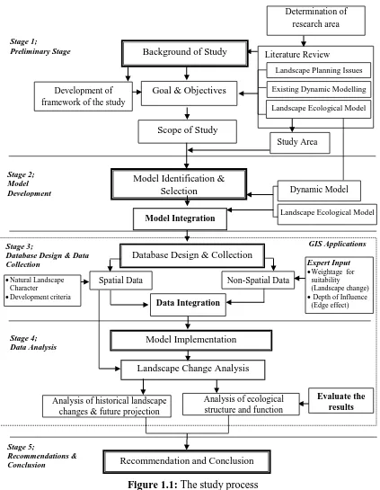
This study comprises several stages which involve various sub-activities in each stage. It includes the identification of the research framework, the model selection and development, the database design and development, the data analysis and recommendations. The outline of the overall process in this study is identified and illustrated in Figure 1.1.
Figure 1.1: The study process
Dynamic Model
Landscape Ecological Model
Expert Input
Weightage for
suitability (Landscape change)
Depth of Influence
(Edge effect) Stage 3;
Database Design & Data Collection
Stage 2; Model Development
Model Identification & Selection
Literature Review
Goal & Objectives Background of Study
Existing Dynamic Modelling Landscape Ecological Model Scope of Study
Stage 1;
Preliminary Stage
Study Area
Database Design & Collection
Spatial Data Non-Spatial Data
Data Integration
Model Implementation
Natural Landscape
Character
Development criteria
Stage 4; Data Analysis
Recommendation and Conclusion
Evaluate the results Stage 5; Recommendations & Conclusion GIS Applications Determination of research area
Landscape Planning Issues
Model Integration Development of
framework of the study
Landscape Change Analysis
Analysis of historical landscape changes & future projection
14
Stage 1 - Preliminary Stage, Finalizing Framework
The first stage of the study focuses on the current situation of landscape change underpinning the theory of sustainable development and landscape ecological assessment. The trend of the urbanization process with ecological impact consideration is analysed to identify the limitation of current applications in landscape change studies. The existing approaches and methods used in ecological modelling are reviewed in relation to the landscape ecological structure and function change due to the interaction with the urban development. The identification of approaches to evaluate the relationship between ecological elements and other land use interaction is conducted to define the possibility of future integration in landscape change study. A comprehensive review based on referred journal, articles, theses, development plan documentation, government publication and books forms the idea of the research and supports the development of the goal and the objectives of the study.
Stage 2 - Model identification and integration
An analysis of the approaches and methods that are currently available, that have been applied in landscape change and landscape ecology studies in the past serves to highlight an approach that could be possibly be used in the integrated landscape change study. Specifically, the methodologies used in past studies are evaluated by taking into account their capabilities in managing multidisciplinary input and spatiotemporal landscape change. The advantages and disadvantages of previous methods and techniques are analysed that refer to the landscape ecological consideration in landscape change study. Although various methods have been used in land use planning and ecology assessment, it is a challenge to identify the possibility to integrate them in the dynamic process of urbanization and ecological quality assessment.
15
landscape ecological assessment employs the landscape index as a tool to analyse the ecological structure and function in landscape change. There are several sub-models involved to analyse the ecological landscape structure change in terms of composition and configuration as well as ecological patches response due to the interaction with the surrounding land use. The quality of the ecological patches is evaluated utilising the Core Area Model that considers the edge effect of the surrounding land use activity. This model is useful to define the quality of remaining fragmented natural landscape areas within other land uses and land covers.
Those models are considered based on their capabilities in the integration with the spatial appearance of the landscape change analysis. Further, the data format is determined and designed to fit the models used in this study. GIS and Remote Sensing are the main tools utilized in this study and all of the data is transformed into their environments. The types and levels of the spatial and non-spatial data are identified in regard to the requirement of the models and research objectives.
Stage 3: Database design and collection
16
Since expert input is another component of the data that is important to support the models, therefore a questionnaire is prepared to acquire the input (Chapter 5, Appendix E and Appendix F). That input emphasizes the suitability and probability analysis of future urban growth areas where the projection of landscape changes is guided by their opinion. At the same time, the experts deliberate on the ecological impact of natural landscape areas in relation to the implication of the interaction between the urban landscape change and ecological sensitivity. This input is an important input because experts describe the depth of the influence of the ecological patches within the complex landscape mosaic. This input is normalized to ascertain a standard value of edge effect which is finally used to assess the quality of natural areas through the core ecological area. This is the loose-coupling method that is used within the GIS environment in this research.
Stage 4: Model Implementation and Data Analysis
At this stage, there are three major analytical processes involved in this study where the established model is implemented in regard to the case study area. The preliminary stage explores the trend of historical landscape change in the study area. The urban expansion pattern and natural landscape area degradation are analysed from 1994 to 2013. Furthermore, the degree of influence of spatial variables involved in the past landscape change is measured through the logistic regression model. The analysis highlights and ranks the criteria that have had a strong influence on the past changes. The historical experiences will serve as a basis for the next stage of the analysis to project the probability of future landscape change in the study area.
17
is set up as a basis for the future projection of the landscape change. The simulation projects the probability of landscape changes in 2020, 2025 and 2030 by using the appropriate historical path. The interpolation of future spatial characteristics is translated using the Cellular Automata model.
In the final part of the analysis, the composition and configuration of the natural landscape area changes are measured using the selected landscape index. Several landscape matrices are utilised to evaluate the condition of natural landscape areas at class and landscape levels. The analysis focuses on the landscape ecological structure changes along the study period. The result shows the loss and fragmentation pattern of the natural landscape due to the spatiotemporal landscape changes in the study area. Moreover, the ecological stability of the remaining natural areas is evaluated based on the landscape structure, mosaic and edge effect from the adjacent land use activities. The edge effect from the surrounding land use activities towards natural areas is considered to delineate the ecological core zone in the natural areas. Input from experts on the depth of influence determines the quality function of ecological elements in the natural landscape areas. The FRAGSTATS software is used to run the analysis and the indexes indicate the condition of natural landscape structure and function within the dynamic landscape changes. The outcome of the analysis is discussed further in relation to LULC change pattern and ecological area consequences. The interpretation of the results emphasizes several aspects of land use planning, policy evolution and the most important aspects in landscape ecology.
Stage 5: Recommendation and Conclusion
18
1.8 Thesis Organization
This thesis consists of seven chapters. The first chapter addresses the background of the study and highlights the issue of landscape change and ecological interaction. It describes the direction and focus of the research through the development of the goal and objectives of the study. The significance of the study is emphasized in this chapter and then the strategy to conduct the study follows.
The next chapter, Chapter 2 discusses the related literature about LULC change in urbanization studies as well as the landscape ecology approach and assessment in landscape change applications. Issues on past landscape change studies are highlighted and critiqued via the underpinning theories of landscape planning and landscape ecology. Then, the existing approaches, methods and techniques are discussed in Chapter 3 with regard to the spatiotemporal landscape change behaviors. Likewise, the discussion on the role of information technology in particular the geographic information system in spatial modeling is highlighted. It is the approach that is used in simulating landscape change in the study area. The established models and techniques with their spatial capabilities are deliberated upon towards the possibility of integration in the landscape change and ecological assessment. All the process involved is determined by formulating the framework of the study. At the end, this chapter formulates the concept and approach used in this study.
The Chapter 4 then discusses the methodology of the research. The development of the framework of the study is explained in the early part of the chapter. This is followed by an explanation of the detailed process involved in the study. Every single process is discussed starting from the data preparation to the analysis stage. The integration of the spatial and non-spatial data is displayed in the data preparation process and in the analysis stage. It is followed by the sequence of analysis processes in landscape change simulation and landscape ecology consideration.
19
spatiotemporal landscape change behaviors. The relationship of variables with the historical landscape change is highlighted as a basis to support input from experts in the preparation of suitability areas for future landscape change. Apart from that, further discussion on the result of the probability of future landscape changes shows the future character landscape change. It relates to the selected rules from the historical experience. The patterns of future landscape changes are visualized in this chapter particularly the landscape ecological area changes.
Meanwhile, the discussion in Chapter 6 focuses on the landscape ecological consequences due to the landscape changes in the past periods and future projection. The discussion emphasizes the landscape ecology structure and function changes. The composition and configuration of the natural landscape changes are justified and then related with the ecological function situation. It reveals the scenarios of the landscape ecological situation for the entire study period through spatial visualization. Graphs and statistical tables support the information of landscape ecological change behavior in the study.
A comprehensive discussion in Chapter 7 deliberates the output from Chapter 5 and Chapter 6 towards improving the landscape change analysis. It relates to achieving the goal of the research and the objectives wherein the landscape ecological function is now highly considered in dynamic landscape change. Furthermore, the results of the study are linked to the implication of policy changes in the study area. It reveals detailed aspects of the ecological consequences from rapid urban development not considered before. This final chapter then synthesizes the findings of the entire study by discussing the achievements of the study approach, the methodology applied and the techniques used in this study. The advantages and disadvantages of the spatial modeling in this research are deliberated upon excluding the limitations of the study. At the end, the chapter suggests possible future research that could be conducted by applying the spatial dynamic modeling method from this study along with improvements.
20
established, it seems that due to the limitation of knowledge and technical support it hinders a better comprehensive decision that could be made. It is vitally important that information on the phenomena in regard to the urbanization and ecological impacts be understood at all levels of the decision-making process. And the prediction in regard to the probability concerning the way it happens must be considered by decision makers in landscape planning. It requires advance technology from information system and the appropriate spatial modelling to manage, organise and address the issues. Thus, this research explores the use of spatial modelling in the LULC change with better landscape ecological assessment. It is hoped that the significance of this study will be able to improve the decision-making process in landscape planning and consequently enable it to sustain ecological values and services in the environment.
274
REFERENCES
Aburas, M. M., Ho, Y. M., Ramli, M. F. and Ash’aari, Z. H. (2017). Improving the capability of an integrated CA-Markov model to simulate spatio-temporal urban growth trends using an Analytical Hierarchy Process and Frequency Ratio. International Journal of Applied Earth Observation and Geoinformation, 59, 65–78.
Albert, C., Galler, C., Hermes, J., Neuendorf, F., Haaren, C. V. and Lovett, A. (2016). Applying ecosystem services indicators in landscape planning and management: The ES-in-Planning framework. Ecological Indicators, 61, 100-113.
Alexandrino, E. R., Buechley, E. R., Karr, J. R., de Barros Ferraz, K. M. P. M. de Barros Ferraz, S. F., do Couto, H. T. Z. and Sekercioglu, C. H. (2017). Bird based Index of Biotic Integrity: Assessing the ecological condition of Atlantic Forest patches in human-modified landscape. Ecological Indicators, 73, 662-675.
Alig, R. J., Kline, J. D. and Lichtenstein, M. (2004). Urbanization on the US landscape : looking ahead in the 21st century. Landscape and Urban Planning, 69, 219–234.
Antrop, M. (2001). The language of landscape ecologists and planners: A comparative content analysis of concepts used in landscape ecology. Landscape and Urban Planning, 55, 163–173.
Abdullah, S. A. and Nakagoshi, N. (2006). Changes in landscape spatial pattern in the highly developing state of Selangor, Peninsular Malaysia. Landscape and Urban Planning, 77, 263–275.
Abdullah, S.A. and Nakagoshi, N. (2007). Forest fragmentation and its correlations to human land use change in the state of Selangor, peninsular Malaysia. Forest
275
Ahris, Y., Mansor, I., Susilawati, S. and Zulherman, M. S. (2000). Assessment of urban development and land use changes’ impaction on the environment: A case study of urban development in Klang Valley region, Malaysia. Proceeding
SENVAR 2000, Surabaya, Indonesia.
An, L. (2012). Modeling human decisions in coupled human and natural systems: Review of agent-based models. Ecological Modelling, 229, 25– 36.
Avon, C., Berges, L, Dumas, Y and Dupouey, J. L. (2010). Does the effect of forest roads extend a few meters or more into the adjacent forest? A study understory plant diversity in managed oak stands. Forest Ecology and Management, 259, 1546-1555.
Al-Badaii, F., Othman, M. S. and Gasim, M. B. (2013). Water quality assessment of the Semenyih River, Selangor, Malaysia. Journal of Chemistry, 2013.
Arsanjani, J. J., Helbichb, M., Kainz, W., Boloorani, A. D. (2013). Integration of logistic regression, Markov chain and cellular automata models to simulate urban expansion. International Journal of Applied Earth Observation and Geoinformation, 21, 265–275.
Ayad, Y. M. (2005). Remote sensing and GIS in modeling visual landscape change: a case study of the northwestern arid coast of Egypt. Landscape and Urban Planning, 73, 307–325.
Backhaus, N. (2011). Regional Environmental Governance: Interdisciplinary Perspectives, Theoretical Issues. Landscape, spatial totalities or special regions? Social and Behavioral Sciences, 14, 193–202.
Baker, S. C., Barmuta, L. A., McQuillan, P. B. and Richardson, A. M.M. (2008). Estimating edge effects on ground-dwelling beetles at clearfeled non-riparian stand edges in Tasmanian wet eucalypt forest. Forest Ecology and
Management, 239, 92-101.
Barau, A. S. (2017). Tension in the periphery: An analysis of spatial, public and corporate views on landscape change in Iskandar Malaysia. Landscape and
Urban Planning, 165, 256–266.
Basnou, C., Iguzquiza, J. and Pino, J. (2015). Examining the role of landscape structure and dynamic in alien plant invansion from urban Mediterranian coastal habitats. Landscape and Urban Planning, 136, 156-164.
Beardsley, K., Thorne, J. H., Roth, N. E., Gao, S. and McCoy, M. C. (2009). Assessing the influence of rapid urban growth and regional policies on biological resources. Landscape and Urban Planning, 93, 172–183.
Bishop. I. D. (2011). Landscape planning is not a game: Should it be? Landscape
276
Bjo, C. and Lo, K. (2002). Biotope patterns in urban areas: a conceptual model integrating biodiversity issues in spatial planning. Landscape and Urban Planning, 58, 223–240.
Bolte, J. P., Hulse, D. W., Gregory, S. V. and Smith, C. (2007). Modeling biocomplexity – actors, landscapes and alternative futures. Environmental Modelling & Software, 22(5), 570–579.
Bone, C. and Dragicevic, S. (2010). Incorporating spatio-temporal knowledge in an Intelligent Agent Model for natural resource management. Landscape and Urban Planning, 96, 123–133.
Broadbent, E. N., Asner, G. P., Keller, M., Knapp, D. E., Oliveira, P. J. C. and Silva, J. N. (2009). Forest fragmentation and edge effects from deforestation and selective logging in the Brazilian Amazon. Biological Conservation, 141, 1745-1757.
Bruun, M. and Smith, H. G. (2003). Landscape composition affects habitat use and foraging flight distances in breeding European starlings. Biological Conservation, 114, 179-187.
Burger, J. and Gochfeld, M. (2016). Initiating events, functional remediation, and assessment of risk to ecological resources. Ecological Indicators, 71, 32–40. Cancino, J. (2005). Modelling the edge effect in even-aged Monterey pine (Pinus
radiate D. Don) stands. Forest Ecology and Management, 210, 159-172.
Caniani, D., Labella, A., Lioi, D. S., Mancini, I. M. and Masi, S. (2016). Habitat ecological integrity and environmental impact assessment of anthropic activities: A GIS-based fuzzy logic model for sites of high biodiversity conservation interest. Ecological Indicators, 67, 238–249.
Castillo, E. M., Martin, A. G., Aladren, L. A. L., Luis, M. M. (2015). Evaluation of forest cover change using remote sensing techniques and landscape metrics in Moncayo Natural Park (Spain). Applied Geography 62, 247-255.
Chaffin, B. C., Garmestani, A. S., Angeler, D. G., Herrmann, D. L., Stow, A. C., Nystron, M., Sendzimir, J., Hopton, M. E., Kolasa, J. and Allen, C. R. (2016).
Journal of Environmental Management, 183, 399-407.
Chazal, J. D. and Rounsevell, M. D. A. (2009). Land-use and climate change within assessment of biodiversity change: A review. Global Environmental Change, 19, 306-315.
277
Chan, K. M. And Vu, T. T. (2017). A landscape ecological perspective of the impacts of urbanization on urban green spaces in the Klang Valley. Applied Geography, 85, 89-100.
Chang, H., Li, F., Li, Z., Wang, R., Wang, R. and Wang, Y. (2011). Urban landscape pattern design from the viewpoint of networks: A case study of Changzhou city in Southeast China. Ecological Complexity, 8, 51-59.
Chen, G., Powers, R. P., Carvalho, L. M. T. and Mora. (2015). Spatiotemporal patterns of tropical deforestation and forest degradation in response to the operation of the Tucuruí hydroelectric dam in the Amazon basin. Applied Geography, 63, 1-8.
Chen, L. and Nuo, W. (2013). Dynamic simulation of land use changes in port city: a case study of Dalian, china Liang. Procedia - Social and Behavioral Sciences 96, 981 – 992.
Chiao, L. Y., Hsieh, C. and Chiu, T. S. (2012). Exploring spatiotemporal ecological variations by the multiscale interpolation. Ecological Modelling, 246, 26-33. Clec’h, S. L., Oszwald, J., Decaens, T., Desjardins, T., Dufour, S., Grimaldi, M.,
Jegou, N. and Lavelle, P. (2016). Mapping multiple ecosystem services indicators: Toward an objective-oriented approach. Ecological Indicators, 69, 508-521.
Clement, F., Ruiz, J., Rodriguez, M. A., Blais, D. and Campeau, S. (2017). Landscape diversity and forest edge density regulate stream water quality in agricultural catchments. Ecological Indicators, 72, 627-639.
Collinge, S. K. (1996). Ecological consequences of habitat fragmentation: implications for landscape architecture and planning. Landscape and Urban Planning, 36(1), 59–77.
Conway, T. M. and Lathrop, R. G. (2005). Alternative land use regulations and environmental impacts: assessing future land use in an urbanizing watershed. Landscape and Urban Planning, 71, 1–15.
Corry, R. C. and Nassauer, J. I. (2005). Limitations of using landscape pattern indices to evaluate the ecological consequences of alternative plans and designs.
Landscape and Urban Planning, 72, 265-280.
Cotter, M., Hauser, I., Harich, F. K., He, P., Sauerborn, J., Treydte, A. C., Martin, K. and Cadisch, G. (2017). Biodiversity and ecosystem services−A case study for the assessment of multiple species and functional diversity levels in a cultural landscape. Ecological Indicators, 75, 111–117.